HAL Id: hal-02498552
https://hal.archives-ouvertes.fr/hal-02498552
Submitted on 5 Mar 2020
HAL is a multi-disciplinary open access
archive for the deposit and dissemination of
sci-entific research documents, whether they are
pub-lished or not. The documents may come from
teaching and research institutions in France or
abroad, or from public or private research centers.
L’archive ouverte pluridisciplinaire HAL, est
destinée au dépôt et à la diffusion de documents
scientifiques de niveau recherche, publiés ou non,
émanant des établissements d’enseignement et de
recherche français ou étrangers, des laboratoires
publics ou privés.
Interactive semantics-driven reconstruction methodology
from Point Clouds
V Frebet, Florent Laroche, Y Koch, Alain Bernard, R Kervadec
To cite this version:
V Frebet, Florent Laroche, Y Koch, Alain Bernard, R Kervadec. Interactive semantics-driven
recon-struction methodology from Point Clouds. 29th CIRP DESIGN 2019 OPEN DESIGN and DESIGN
AS EXPONENTIAL TECHNOLOGY, May 2019, Póvoa de Varzim, Portugal. �hal-02498552�
Procedia CIRP 00 (2019) 000–000 www.elsevier.com/locate/procedia
29th CIRP Design 2019 (CIRP Design 2019)
Interactive semantics-driven reconstruction methodology from Point Clouds
V. Frebet
a,b, F. Laroche
a, Y. Koch
b, A. Bernard
a, R. Kervadec
baLaboratory of Digital Sciences of Nantes (LS2N), Bˆatiment 34, 2 Chemin de la Houssini`ere BP 92208, 44322 Nantes Cedex 3 , France bTagLabs, 1, rue de la No¨e, Incubateur Centrale - Audencia - Ensan, Nantes, 44300, France
Abstract
3D point cloud acquisition has become a common practice in the AEC Industry (Architecture, Engineering and Construction). With the emer-gence of BIM (Building Information Modeling), more and more industrials are interested in creating an ”as-built” CAD model of their facilities. The transition from point cloud to a digital model is currently an extremely tedious task due to the large volume of data and the uniqueness of each scanned environment. Many researches are directed towards an automatic extraction of structural and piping elements of increasing complexity. The result however, is a geometry devoid of meaning, or a semantic classification of specific objects in very limited number.
In this article, we highlight the context and industrial needs for a generic object reconstruction method and we present the state-of-the art of manual and automatic methods. We then propose a semi-automatic reconstruction method combining semantization with 3D digitization of objects.
We review the most recent methods for each operation. Finally, we identify and discuss the technological gaps that need to be addressed in our future research.
c
2019 The Authors. Published by Elsevier B.V.
Peer-review under responsibility of the scientific committee of the CIRP Design Conference 2019. Keywords: As-Built BIM; Semantics-driven; 3D object retrieval; 3D shape decomposition
1. Introduction
3D surveys are accurate, almost exhaustive, and done in a limited time. Most of the time, they are generated using a ter-restrial laser scanner(TLS) that rotates to capture the elements in the scene at a rate of several hundred thousand points per second. Point cloud is an excellent information carrier and as a visualization aid, it provides the possibility to examine a lo-cation remotely from multiple viewpoints. The points can be manipulated, hidden, colorized, removed - pushing the limits of human perception. Point clouds allows distance and surface flatness measurement [2] even on humanly inaccessible areas -allowing companies to carry out prefabrication operations. Es-pecially in the industrial sector, a lot of ressources are wasted when technicians have to go on site to perform control mea-surements [3].
∗
Corresponding author. Tel.:+33-783-744-389
E-mail address:[email protected] (V. Frebet).
Still the true potential of 3D surveys is on the information enrichment and the recognition of objects to 3D computer-aided design (CAD) model of the scene [1]. Indeed for the last decade, point clouds acquisition have significantly aided the expansion and democratization of BIM (Building Information Modelling) among professionals of architecture and civil engineering. 1.1. ”As-Built” BIM
The BIM is a process based on information transactions and requires collaborative workflows. It works with a digital rep-resentation for physical and functional characteristics of build-ings. [13] describes ”As-Built” BIM as a BIM representation of a building at the moment of the 3D survey. One could use the terms ”As-Existing” or ”As-Is” instead of ”As-built”, as a building could suffer from deformations in its life cycle and in-deed be different from the time it has been built.
As-built spatial modelling for facilities is the process of cap-turing the infrastructure spatial data and transforming it into a structured, object-oriented representation. [7] describes this transformation with 3 major steps :
• Geometrical modelling of building elements. • Integrating semantic information with each element.
2212-8271 c 2019 The Authors. Published by Elsevier B.V.
V. Frebet et al./ Procedia CIRP 00 (2019) 000–000 2
• Establishing relationships between elements.
This representation is suitable for generating useful informa-tion valuable to architects, engineers, constructors, owners, in-spectors and maintainers. A project’s stakeholders can use spa-tial modelling in order to solve complex problems such as identifying deviations from design, quantity take-off, real-time monitoring of construction progress, project management, and 3D/4D simulation, maintenance, during different phases of a fa-cility’s life cycle.
1.2. Problem statement 1.2.1. Business Issues
Building owners or industries usually appoint scanning ser-vice providers to scan their facilities and register clouds to form a coherent representation. As the process of conversion to an ”As-Built” CAD model is an laborious and manual task [7][15], service providers often call on modelling campanies in an abroad country with cheaper labor cost. This 2-stages course of action often results in lost of communication, errors and overmodelling. Bringing modellisation to building stakehold-ers would grant them flexibility for small and medium-sized project where current ”scan to BIM” processes often disregard them [5]. ”Scan to BIM” is a term given to the survey process of capture to model. [4] describes this concept as wrongly for-mulated because the end result is not BIM but a 3D parametric model that assists the BIM process at its current level of devel-opment.
1.2.2. Technical Issues
In this paper, we qualify as point cloud, data delivered by terrestrial laser scanner (TLS), not handheld laser scanner nor aerial LiDAR nor CMM oriented laser scanner.
Their are several challenges going along 3D Reconstruction from point clouds such as:
• The high variation of point density [6]
• The inaccuracy of the input data [29] (digital noise from the scanner or scanned environment) due to the presence of :
– specular surfaces [9], – moving objects [11], – registration errors [8]
– the type of material of scanned surface[10] • Occlusion and clutters which inherently implies to deal
with partial data [12].
• The diversity of elements present in industrial environ-ments.
• Distinguishing elements that have similar shape. One can take the example of a wall and a partition wall, both el-ements are flat and vertical surfaces with a close texture. Nevertheless for a building professional making a dis-tinction between these two elements is paramount.
1.3. Aim and structure
In section2, a review of the current 3D reconstruction meth-ods, manual, semi-automatic and automatic, to BIM object is drawn. Section 3, describes a semi-automatic reconstruction method combining semantization with 3D digitization of ob-jects. We sub-divide the process into four steps:
• A semantic enrichment by a Tag from the user.
• Corresponding the semantic entity to a constrained graphs describing the topological relations of the prim-itive forms.
• Modelling of geometric primitives. • Adjustment of the CAD object.
2. Related Work
In this section, we review the different forms of represen-tation to describe an object. We then assess reconstruction method per their level of automation, manual, automatic and semi-automatic.
2.1. Representing the shape of objects
Similar to the work presented in [7] and in [13], in the con-text of ”As-Built” BIM, shape description of object can be sep-arated in three aspects: parametric or non-parametric, global or local, explicit or implicit.
• Parametric vs. non-parametric representation With a parametric representation, the shape is described with a small number of parameters. [7] gives as an example, a cylinder represented non-parametrically with a trian-gle mesh. In the heritage sector, meshes are used to di-rectly convert cloud of points to CAD Design [20]. In-deed ornaments or deterioration over time on a struc-ture, with sometimes a significant geometric complexity, makes it hard to model with a parametric representation, even though HBIM process (Historic Building Informa-tion Modelling) introduced in [21], proposed a library of parametric architectural objects.
• Local vs. Global representation
Local representation describes a portion of an ob-ject which parametric representations are often associ-ated. Intensive researches has been done on local sur-face feature based methods for 3D object recognition [24][26][25][23][27][28]. These methods generally con-sist of three phases :
– 3D keypoint detection [25] are points of a shape that are prominent according to a particular defini-tion to recognize or classify point clouds at different scales.
– local surface feature description which consist of encoding geometric information on a point or within its neighborhood.
– surface matching which contains three steps, i.e, feature matching, hypothesis generation and veri-fication [24].
For global representations, the area of interest includes the object as a whole, this has the consequence of hav-ing a detection sensitive to occlusions. Generally meth-ods adopting global descriptors expect to have properly segmented and complete objects, which is certainly not the case in a industrial environment.
• Explicit vs. implicit representation
Explicit representation is a direct encoding of the shape of the object (i.e. polygon mesh, bezier surfaces, NURBS, B-Rep, CSG).
Implicit representation allows an indirect encoding for the shape of the object, using an intermediate represen-tation.
In industrial environments, we assumed that most objects under consideration can be well represented by a set of prim-itive shapes(planes, spheres, cylinders, cones and tori). [61]
2.2. Manual Reconstruction Methods
As of today, the digital modelling of building and MEP (Me-chanical Electrical and Plumbing) is a manual task and consid-ered a particularly time-consuming, subjective [43], laborious one requiring skilled operators. [16] [8] It needs importante ex-pertise for an operator to interprete the scene, as well as enrich-ing the model with semantic informations. Even with trainenrich-ing, results can differ from 2 operators.
Take for example the modelling of walls, since tracing the points in a 3D space is difficult, the process consists of drawing 2D sketches, then extruding, using an orthophoto of a trimmed point cloud as a guide. Usually this work is done using Au-todesk Revit Architecture.
Another process of manual reviewed in [14], consist in an operator stitching 3D surface with some algorithm help follow-ing with identifyfollow-ing the object which is fitted after a proper search in a database of standardized object. Then, as-built at-tributes can be assigned manually.
2.3. Automated Reconstruction Methods
The focus of academic research has mainly been oriented on algorithms aiming at automatic segmentation, modelling of geometry and labeling of 3D LiDAR point clouds. Due to the large size of collected point clouds, automatic algorithms is said to be preferable to reduce the necessity of expensive and slow human processing.
Their is a division of research between geometry detection, which primarily focus on point cloud segmentation, and under-standing, which primarily focus on object detection then lead-ing on to model construction [4]. Researches are still on going to join those two approaches into a multistage method for ge-ometry reconstruction.
2.3.1. Indoor Modelling
Work reported from the literature can be classified into two broad categories. One focus on the modeling of spaces [62] and the other on the modelling of elements composing the building [31] , i.e, walls and slabs [32]. [33], [17] and [58] use Condi-tional Random Field (CRF) model that exploit contextual in-formation to classify extracted planar patches to reconstruct a semantic 3D models of indoor environements. Their approach differs from other that rely on hard-coded rules represented by a semantic network, such as strict orthogonal constraints between walls and floors [44].
[59] developped an automatic indoor reconstruction method-ology focusing on common rooms in modern construction. With successive operations of ground plan detection, occlu-sion labelling, opening detection and classification, the output of the developed method consists of a set of labelled planar patches (walls, ceiling, and floor), their connections with ad-jacency maps and a set of openings detected within each planar surfaces.
2.3.2. MEP Modelling
There has been a growing demand for the 3D reconstruction of MEP (Mechanical Electrical Plumbing) elements, with his-torically a focus on pipes and elbows.
The 3D reconstruction process of as-built pipelines has been on manual interaction and interpretation which is difficult, re-quiring skilled personnel with an high level of knowledge to identify each pieces of pipeline only with their appearance in the unstructured 3D point clouds (e.g., valves, pumps, heaters, exchangers)[35].
There have been efforts over the last decade to automate this process, [39] gives a review of automated as-built modeling methods
2.4. Semi-automatic reconstruction
Work on interactive tools for point cloud focus on segmen-tation and labeling. [55] proposes an approach where the user can correct a segmentation performed by an automatic algo-rithm using strokes. After the segmentation is completed, each region is used to retrieve a matching 3D model from a database. [54] presents a semi-automated method for shape detection with a user-controlled segmentation. The lasso interaction is improved by performing selection on points that suits a detected shape.
[60] proposes a system allowing users to quickly and interac-tively label the environment using a RGB-D camera in real-time and through voice commands. Then a volumetric fusion algo-rithm reconstructs the scene in 3D with additional color data.
3. Our contribution
In 2.3, we reported that current 3D ”As-built” reconstruc-tion of building elements or MEP often lean towards automa-tion with little or even no user intervenautoma-tion. In softwares, like EdgeWise (Trimble), that offers automatic geometry retrieval, 3
V. Frebet et al./ Procedia CIRP 00 (2019) 000–000 4
Fig. 1. Our method of an interactive semantic enrichment process
it goes as far as condemning skilled operators to an important and dull backchecking task of errors commited by the machine. The goal is ultimately to transform a point cloud directly to a BIM-ready semantically-enriched CAD model.
However, due to the high complexity of industrial scenes and the limitation of 3D scanners, manual intervention cannot be avoided [56]. [52] adresses this problem as an interface prob-lem, stating ”if a machine cannot meet the required accuracy and needs continuous guidance and interaction with the user, as valuable as it is to continue improving the learning component of the system, it is important to make the existing algorithms ef-ficiently interact with the currently inevitable human presence in the loop”.
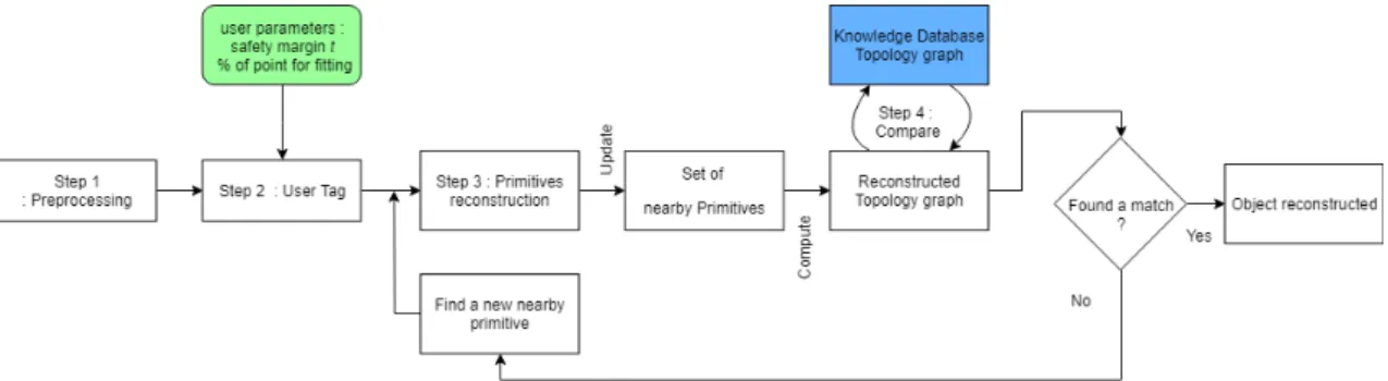
In this aspect, we raise the need of a more interactive seman-tic enrichment process. We present here our semi-automatique reconstruction method combining semantization with 3D digi-tization of objects fig.1.
The process starts once a user selects a point in the cloud, a precision parameter and a safety margin parameter, he can label it as an object, e.g a wall. The wall is an object defined in a knowledge database and is symbolized by a topological graph of two parallel planes. From the selected point, a re-gion of points is grown from which a model fitting algorithm determines the best fitting plane. It is then added to a set of primitives from which we compute a topological graph that is compare to the knowledge database topological graph. Until a match is found, we search for new primitives nearby and update our graph.
We subdivide the process into four steps: • Step 1 : Preprocessing
• Step 2 : Semantic enrichment by a Tag from the user. • Step 3 : Multiple primitives reconstruction
– Step 3.1 Point cloud Segmentation.
– Step 3.2 Modelling of geometric primitives. • Step 4 : From primitives to object using a knowledge
database
3.1. Step 1 : Preprocessing
The preprocessing consists in partitionning the unstruc-tured cloud using an octree structure [41]. In his work, Wim-mer presents an algorithm capable of displaying enormous
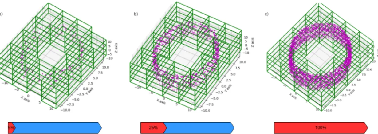
unprocessed point clouds at interactive rates by making use of nested octrees and memory optimized sequential point trees(MOSPT). MOSPT is an improved version of sequential point trees(SPT)[50] which is a data structure that allows adap-tive rendering of point clouds completely on the graphics card, the point tree’s nodes are rearranged into a list, sorted by depth. It allows access to different level of detail using indices of ar-ray fig.2, i.e, gradually display points depending on the distance between camera and the object.
In this octree form, all nodes are recursively split into eight identical children, resulting in all nodes at the same depth being the same size. We qualify as voxel, the cubic volume of deepest nodes in octree. The voxel grid because of its spatial structure allows rapid and easy searching for adjoining voxels.
Similar to the work of [40], which consists in an octree-based region growing segmentation, we estimate three features derived from the point distribution in each voxel, a normal vec-tor, a barycentre and a residual value. We apply a Principal Component Analysis to compute those features by first fitting a plane characterized by its barycentre and its normal vector, then evaluate the residual. The residual value has been intro-duced with the work of [42] and is a scalar representation of the surface curvature thus impacted by the noise data.
3.2. Step 2 : Semantic enrichment by a tag
We define as a tag, an annotation designating an object to be reconstruct, and linked to a point on the cloud. Each tag is unique and has hierarchical structure according to a system de-composition, e.g. a radiator is a component which is part of a branch which is part of the heat network, that runs through all the buildings. Similar to the object hierarchy utilized in Revit, object are decomposed into family, type, instance.
3.3. Step 3 : Multiple primitive reconstruction
For primitive reconstruction, we refer to Ahn’s book [38], that presents algorithms for least squares orthogonal distance fitting (ODF) of curves and surfaces. Orthogonal distance is defined as the shortest geometric distance between the model feature and the measurement points, it is use as the error mea-sure to be minimized. Our approach to geometrical primitive fitting is similar to Ahn’s object recognition procedure called 4
Fig. 2. Representation of a cylinder with different level of detail with MOSPT ; a) 200 points = 5 per/cent total points ; b) 1000 points = 25 per/cent total points c) 4000 points= 100 per/cent total points
’Click & Clear’. It is an interactive process aiming at building a parametric model of geometric primitives, by a iterative re-fining scheme combining segmentation (Step 3.1) and model fitting (Step 3.2). The model fitting is also preceded by an out-lier operation and followed by an assessment of its parameters. The model parameters obtained, define the form and the orien-tation of the geometric primitives in space. The outlier detection consist in excluding outliers from model fitting and focus on calculating orthogonal distance with inliers as this calculation is the time-consuming step in the procedure. Inliers are deter-mined by testing if they belong inside a domain volume defined around the model feature with a safety margin t, e.g, a sphere has four parameters, position Xc, Yc, Zc of the center c and ra-dius r of the sphere, the domain volume is defined between two spheres of center c and radius r − t and r+ t fig.3.
The safety margin t is set by the user, it is intuitive by users with a mechanical background. Indeed many segmentation or model fitting methods employ a large number of parameters, that are often not clear to the unexperienced user, and it needs several attempts to find the best set of parameters [42]. Com-pare to algorithms such as Random Sample Consensus [63] and its extension(MLESAC, etc...), that are overwhelmingly recog-nized as one of the fastest reconstruction algorithm, often used in real time application, Ahn’s procedure has more analytical and computation difficulties. However, because of its iterative scheme of fitting parametric model, low-level model feature (such as plane) are employed for parameter initialization, en-abling a stable and robust convergence fig. 4. As a result of this model hierarchy, the primitive reconstruction can be greatly automated, leaving the seed selection to the user. Detection is launch without specifically naming the type of primitive to be fitted.
Ray tracing algorithm [45] is used to estimate which is the closest point from where a user clicked. From this seed point, an octree-based K-Nearest Neighbor algorithm [51] is launched to create a small patch of points. It serves initializing the model parameters through ODF algorithms, and the searching domain volume.
In the iterative refining scheme, we exploit the octree spatial decomposition to apply outlier detection and model fitting to
points inside the seed point voxel and its neighbors. To speed up the process, we can grow a region of voxels by comparing their features to the original seed point voxel and testing whether or not their barycentre is inside the domain volume. When the region can no longer be grown and the model fitting has been reassess we reconsider boundary voxels as new seed voxel for a new step of segmentation.
The number of points is certainly affecting the duration of every operations of model fitting. In addition, detecting a high variety of objects with different sizes is very challenging, even more because of our interactive procedure and expectation of performance as close to realtime as possible. In this aspect, we propose to let the user specify the level of detail as a parameter, i.e, the pourcentage of points for the fitting step by exploiting MOSPT linear memory structure.
3.4. Step 4 : From primitives to object using a knowledge database
Our motivation for a generic reconstruction procedure of se-mantically enriched object relies on a priori geometric infor-mation embedded in tags. This inforinfor-mation characterizes the geometric knowledge of an object and it’s congregate in an knowledge database, e.g, I-shaped beam can be decomposed in a set of planes with topological relationship between those primitives.
In2.1, we stated that a local implicit parametric shape rep-resentation is best suited for our objects. We then derive it to a topology graph similar to [61] describing the relations between primitives shapes. For each primitive a vertex is inserted into the graph, and are connected with an edge. Detection of an ob-ject is reduced to a graph matching problem. For matching a tagged object to its analogue in the object collection we try to match subgraphs. Unlike [61] which defined their graph once all shapes in the cloud are determined, our approach is interac-tive, and all possible set of primitives shapes are not necessarily established, therefore we need to construct our topology graph in real-time. We need constant interactions between the knowl-edge database and topology graph to assert matching between the set of primitives.
V. Frebet et al./ Procedia CIRP 00 (2019) 000–000 6
Fig. 3. Representation of a cylinder in a octree structure. purple dot : points black cross : barycenter of each voxels red circle : estimated cylinder model of radius r blue circles : associated search domains r ± t
Fig. 4. Evolution of model feature from plane to cone or helix [38]
4. Conclusions
The reconstruction of objects by semantic enrichment is still a developing field of research. As of today, current automatic methods is used for specific tasks of indoor modelling or classi-fication with a limited number of distinct objects. It is conceiv-able that our approach may facilitate futur creation of labeled datasets hence opening doors for artificial intelligence experts to improve or create new models.
In this article, we have presented a methodology of object reconstruction launched by a user annotation on point cloud. We undeniably try to put forth the user with mechanical and/or structural and/or piping and/or managerial background in the center of industrial modelling. We oriented our approach to be on par with needs of industrials and to overcome challenges with laser data of their environment.
References
[1] Su Y., Bethel J.,Hu S., 2016. Octree-based segmentation for terrestrial Li-DAR point cloud data in industrial applications. ISPRS Journal of Pho-togrammetry and Remote Sensing, volume 113, pp. 59-74.
[2] Bosche F. ,Guenet E., 2014. Automating surface flatness control using ter-restrial laser scanning and building information models. Automation in Construction, volume 44, pp. 212-226.
[3] Svedberger J. and Andersson J., 2013. Laser scanning in manufacturing in-dustries. Master of Science Thesis IIP 2013:x, KTH Industrial Engineering and Management, Industrial Production, SE-100 44 STOCKHOLM. [4] Patrick C., Thomson H., Boehm J., Ellul C., 2016. From Point Cloud to
Building Information Model, PHD thesis, 267 pages.
[5] Lamaille G., Lahaye J., Vandenbergh T., 2016. L’utilisation du Scanning Laser 3D pour la documentation as-built des projets BIM. Revue
Scien-tifique des Ing´enieurs Industriels n 30, 2016.
[6] Anil E., Akinci B., Huber D., 2011. Representation requirements of as-is building information models generated from laser scanned point cloud data, Proceedings of the 28th International Symposium on Automation and Robotics in Construction, pp 355-360.
[7] Tang P., Huber D., Akinci B., Lipman R., Lytle A., 2010. Automatic recon-struction of as-built building information models from laser-scanned point clouds: A review of related techniques. Automation in Construction 19, pp 829–843.
[8] Hajian H. and Becerik-Gerber B., 2010. Scan to BIM: Factors Affecting Operational and Computational Errors and Productivity Loss, 27th Inter-national Symposium on Automation and Robotics in Construction (ISARC 2010).
[9] Kashammer P.-F. and Nuchter A., 2015. MIRROR IDENTIFICATION AND CORRECTION OF 3D POINT CLOUDS, The International Archives of the Photogrammetry, Remote Sensing and Spatial Information Sciences, Volume XL-5/W4, 2015 3D Virtual Reconstruction and Visual-ization of Complex Architectures, 25-27 February 2015, Avila, Spain [10] Voegtle T., Schwab I., Landes T., 2008. Influences of different materials
on the measurements of a terrestrial laser scanner (TLS), The International Archives of the Photogrammetry, Remote Sensing and Spatial Information Sciences. Vol. XXXVII. Part B5. Beijing 2008.
[11] Litomisky K., Bhanu B., 2013. Removing Moving Objects from Point Cloud Scenes. In: Jiang X., Bellon O.R.P., Goldgof D., Oishi T. (eds) Ad-vances in Depth Image Analysis and Applications. WDIA 2012. Lecture Notes in Computer Science, vol 7854. Springer, Berlin, Heidelberg. [12] Adan A. and Huber D., 2011. 3D Reconstruction of Interior Wall Surfaces
Under Occlusion and Clutter, Proceedings - 2011 International Conference on 3D Imaging, Modeling, Processing, Visualization and Transmission, 3DIMPVT 2011, pp 275-281.
[13] Hichri N., Stefani C., De Luca L., Veron P. Review of the “ as-buit BIM ” approaches. 3D-ARCH International Conference, 2013, Trento, Italy. Proceedings of the 3D-ARCH International Conference, pp.NA, 2013. < hal − 01178697 >.
[14] Brilakis I., Lourakis M., Sacks R., Savarese S., Christodoulou S., Teizer J., Makhmalbaf A., 2010. Toward automated generation of parametric BIMs
based on hybrid video and laser scanning data Brilakis, Advanced Engi-neering Informatics 24 (2010), pp 456–465.
[15] Volk R., Stengel J., Schultmann F., 2013. Building Information Modeling (BIM) for existing buildings — Literature review and future needs, Au-tomation in Construction vol 38, pp 109-127.
[16] Rajala M., Penttil¨a H., 2006. Testing 3D Building Modelling Framework In Building Renovation, session 6: information systems - eCAADe 24. [17] Xiong X., Adan A., Akinci B. and Huber D., 2013. Automatic creation of
semantically rich 3D building models from laser scanner data. Automation in Construction vol 31, pp 325-337.
[18] Ochmann S., Vock R., Wessel R., Klein R., 2015. Automatic reconstruc-tion of parametric building models from indoor point clouds, Computers & Graphics vol. 54, pp 94–103
[19] Li X., Han C., Wee W., 2009. On surface reconstruction: A priority driven approach, Computer-Aided Design vol. 41, pp 626-640.
[20] Laroche F., Lefevre D., Servieres M.,Hervy B., Bernard A., 2012. Intelli-gent reverse-engineering segmentation: automatic semantic recognition of large 3D digitalized cloud of points dedicated to heritage objects, Proceed-ings of the 11th Biennial Conference on Engineering systems design and analysis ESDA 2012, July 2-4, 2012, Nantes, France.
[21] Murphy M., McGovern E., Pavia S., 2009. Historic building informa-tion modelling (HBIM), Structural Survey vol. 27, issue : 4, pp 311-327. https://doi.org/10.1108/02630800910985108
[22] Hakonen A., Kuusela J. and Okkonen J., 2015. Assessing the application of laser scanning and 3D inspection in the study of prehistoric cairn sites; , JASREP vol. 2, pp 227-234.
[23] Alhamzi K., Elmogy M., Barakat S., 2015. 3D Object Recognition Based on Local and Global Features Using Point Cloud Library, International Journal of Advancements in Computing Technology (IJACT) vol. 7, Num-ber 3, May 2015.
[24] Guo Y., Bennamoun M., Sohel F., Lu M., Wan J., 2014. 3D Object Recog-nition in Cluttered Scenes with Local Surface Features: A Survey, IEEE Transactions on Pattern Analysis and Machine Intelligence 2014 vol. 36, issue 11, pp 2270-2287.
[25] Garstka J., Peters G., 2015. Fast and Robust Keypoint Detection in Un-structured 3-D Point Clouds, 12th International Conference on Informatics in Control, Automation and Robotics(ICINCO 2015), Colmar, France, July 21-23 2015.
[26] Lu M., Guo Y., Zhang J., Ma Y., Lei Y., 2014. Recognizing Objects in 3D Point Clouds with Multi-Scale Local Features, Sensors (Switzerland) vol. 14, issue 12, pp 24156-24173.
[27] Bianchi M., 2015. Automatic object shape recognition through point clouds analysis, Master of Science in Space Engineering.
[28] Han X., Jin J., Xie J., Wang M., Jiang W., 2018. A comprehensive review of 3D point cloud descriptors, arXiv:1802.02297v1 [cs.CV] 7 Feb 2018. [29] Berger M., Tagliasacchi A., Seversky L.M. , Alliez P., Guennebaud G.,
Levine J.A. , Sharf A. and Silva C. T., 2017. A Survey of Surface Recon-struction from Point Clouds, Computer Graphics Forum vol. 36, issue 1, pp 301-329.
[30] Macher H., Grussenmeyer P., Landes T., 2017. Du nuage de points `a la maquette num´erique de bˆatiment : Reconstruction 3D semi-automatique de bˆatiments existants, Universit´e de Strasbourg, France.
[31] Huber D., Akinci B., Adan A., Okorn B., Xiong X., 2011. Methods for Automatically Modeling and Representing As-built Building Information Models, Proceedings of 2011 NSF Engineering Research and Innovation Conference, Atlanta, Georgia.
[32] Quintana B., Prieto S. A., Ad´an A., Bosch´e F., 2018. Door detection in 3D coloured point clouds of indoor environment, Automation in Construction vol. 85, issue OCtober 2017, pp 146-166.
[33] Xiong X., Adan A., Akinci B., Huber D., 2013. Automatic creation of se-mantically rich 3D building models from laser scanner data, Automation in Construction vol. 31, pp 325-337.
[34] Son H., Kim C., Kim C., 2015. 3D reconstruction of as-built industrial instrumentation models from laser-scan data and a 3D CAD database based on prior knowledge, Automation in Construction 49 (2015), pp 193–200. [35] Son H., Kim C. and Kim C., 2015. Fully Automated As-Built 3D Pipeline
Extraction Method from Laser-Scanned Data Based on Curvature Compu-tation, Journal of Computing in Civil Engineering vol. 29, issue 4, 2015.
[36] Kawashima K. ,Kanai S. ,Date H., 2013. Automatic recognition of ppip-ing system from laser scanned poiint clouds usppip-ing normal-based region growing, ISPRS Annals of the Photogrammetry, Remote Sensing and Spa-tial Information Sciences, Volume II-5/W2, 2013 ISPRS Workshop Laser Scanning 2013, 11 – 13 November 2013, Antalya, Turkey.
[37] Czerniawski T., Nahangi M., Haas C., Walbridge S., 2016. Pipe spool recognition in cluttered point clouds using a curvature-based shape descrip-tor, Automation in Construction vol. 71, issue Part 2, pp 346-358. [38] Ahn S.J., 2004. Least Squares Orthogonal Distance Fitting of Curves and
Surfaces in Space, Lecture Notes in Computer Science 3151.
[39] Sharif M., Nahangi M., Haas C., West J., 2017. Automated Model-Based Finding of 3D Objects in Cluttered Construction Point Cloud Models, Computer-Aided Civil and Infrastructure Engineering vol. 32 (2017), is-sue 11, pp 893–908.
[40] Vo A., Truong-Hong L., Laefer D. F., Bertolotto M., 2015. Octree-based Region Growing for Point Cloud Segmentation, ISPRS Jour-nal of Photogrammetry and Remote Sensing, June 2015 DOI: 10.1016/j.isprsjprs.2015.01.011.
[41] Wimmer M., Scheiblauer C., 2006. Instant Points: Fast Rendering of Un-processed Point Clouds, Eurographics Symposium on Point-Based Graph-ics (2006).
[42] Rabbani T., Van den Heuvel F. A., Vosselman G., 2006. Segmentation of point clouds using smoothness constraint, ISPRS Commission V Sympo-sium ’Image Engineering and Vision Metrology’, IAPRS Volume XXXVI, Part 5, Dresden 25-27 September 2006.
[43] Xiong X., Huber D., 2010. Auto-creation of semantic 3D models, Using Context to Create Semantic 3D Models of Indoor Environments, British Machine Vision Conference, BMVC 2010, Aberystwyth, UK, August 31 -September 3, 2010.
[44] N¨uchter A., Hertzberg J., 2008. Towards semantic maps for mobile robots, Robotics and Autonomous Systems vol. 56, pp 915–926.
[45] Elseberg J., Borrmann D., N¨uchter A., 2012. One billion points in the cloud – an octree for efficient processing of 3D laser scans, ISPRS Journal of Photogrammetry and Remote Sensing vol. 76, pp 76–88.
[58] Bassier M., Bonduel M. , Van Genechten B. and Vergauwen M. ,2017. Segmentation of large unstructured point clouds using octree-based region growing and conditional random fields, The International Archives of the Photogrammetry, Remote Sensing and Spatial Information Sciences, Vol-ume XLII-2/W8, 2017 5th International Workshop LowCost 3D – Sensors, Algorithms, Applications, 28–29 November 2017, Hamburg, Germany. [47] Ayala D., Brunet P., Juan R., Navazo I., 1985. Object representation by
means of nonminimal division quadtrees and octrees. ACM Transactions on Graphics 4 (1), pp 41–59.
[48] Pull K., Duchamp T., Hoppe H., McDonald J., Shapiro L., Stuetzle W., 1997. Robust meshes from multiple range maps, International Conference on Recent Advances in 3-D Digital Imaging and Modeling, pp. 205–211. [49] Wang J., Oliveira M., Xie H., Kaufman A., 2005. Surface reconstruction
using oriented charges, International 2005 Computer Graphics. IEEE Com-puter Graphics International 2005, pp. 122–128.
[50] Dachsbacher C., Vogelgsang C., Stamminger M., 2003. Sequential Point Trees, ACM Transactions on Graphics, 2003, vol. 22, issue 3, pp 657. [51] Behley J., Steinhage V., Cremers A. B., 2015. Efficient radius neighbor
search in three-dimensional point clouds, IEEE International Conference on Robotics and Automation (ICRA) Washington State Convention Center Seattle, Washington, May 26-30, 2015
[52] Boyko A. S., 2015. Efficient interfaces for accurate annotation of 3D point clouds, Faculty of Princeton University, New Jersey, USA.
[53] Weinmann M., Jutzi B., Mallet C., 2014. Semantic 3D scene interpretation: a framework combining optimal neighborhood size selection with relevant features, ISPRS Annals of the Photogrammetry, Remote Sensing and Spa-tial Information Sciences, Volume II-3, 2014 ISPRS Technical Commis-sion III Symposium, 5 – 7 September 2014, Zurich, Switzerland. [54] Rainer B., Mitwirkung M. W., Schw¨arzler M., 2017. Interactive Shape
De-tection in Out-of-Core Point Clouds for Assisted User Interactions. [55] Shao T., Xu W., Zhou K., Wang J., Li D., Guo B., 2012. An Interactive
Approach to Semantic Modeling of Indoor Scenes with an RGBD Camera, ACM Trans. Graph. vol.31, issue : 6, pp 136:1–136:11.
[56] Yang S., Xu J., Chen K., Fu H., 2017. View suggestion for interactive
V. Frebet et al./ Procedia CIRP 00 (2019) 000–000 8 mentation of indoor scenes. Computational Visual Media vol. 3, issue 2, pp
131-146.
[57] Nguyen A., Le B., 2013. 3D point cloud segmentation: A survey, IEEE Conference on Robotics, Automation and Mechatronics, RAM - Proceed-ings, 2013.
[58] Bassier M., Bonduel M., Van Genechten B., Vergauwen M., 2017. Segmen-tation of large unstructured point clouds using octree-based region grow-ing and conditional random fields, The International Archives of the Pho-togrammetry, Remote Sensing and Spatial Information Sciences, Volume XLII-2/W8, 2017 5th International Workshop LowCost 3D – Sensors, Al-gorithms, Applications, 28–29 November 2017, Hamburg, Germany. [59] Previtali M., Barazzetti L., Brumana R., Scaioni M., 2014. Towards
auto-matic indoor reconstruction of cluttered building rooms from point clouds, ISPRS Annals of the Photogrammetry, Remote Sensing and Spatial Infor-mation Sciences, Volume II-5, 2014 ISPRS Technical Commission V Sym-posium, 23 – 25 June 2014, Riva del Garda, Italy.
[60] Valentin J., Vineet V., Cheng M. M, etc, 2015. SemanticPaint: Interactive 3D Labeling and Learning at your Fingertips, ACM Transactions on Graph-ics, Vol. 34, No. 5, Article 106, 2015.
[61] Schnabel R., 2009. Efficient Point-Cloud Processing with Primitive Shapes, Computer graphics technical reports pp 174.
[62] Tran H.,Khoshelham K., Kealy A., D´ıaz-Vilari˜no L., 2017. Extracting topological relations between indoor spaces from point clouds. ISPRS An-nals of the Photogrammetry, Remote Sensing and Spatial Information Sci-ences, Volume IV-2/W4, ISPRS Geospatial, pp 18–22 September 2017, Wuhan, China.
[63] Fischler M. A., Bolles R. C., 1981. Random sample consensus: a paradigm for model fitting with applications to image analysis and automated car-tography, Communications of the ACM CACM,Volume 24, Issue 6, June 1981, pp 381-395 .
![Fig. 4. Evolution of model feature from plane to cone or helix [38]](https://thumb-eu.123doks.com/thumbv2/123doknet/14509475.529414/7.892.165.750.305.505/fig-evolution-model-feature-plane-cone-helix.webp)
