COPLEY SQUARE:
REALIZING ITS FULL POTENTIAL
REAZ HAQUE
Bachelor of Architecture
Bangladesh University of Engineering and Technology
Dacca, Bangladesh.
1979
Master of Architecture
Iowa State University
Ames, Iowa
1982
SUBMITTED TO THE DEPARTMENT OF ARCHITECTURE
IN PARTIAL FULFILMENT OF THE REQUIREMENTS OF THE DEGREE MASTER OF SCIENCE IN ARCHITECTURE STUDIES AT THE
MASSACHUSETTS INSTITUTE OF TECHNGLOGY SEPTEMBER, 1984
®
Reaz Haque 1984The Author hereby grants to M.I.T.
permission to reproduce and to distribute publicly copies of this thesis document in whole or in part.
Signature of the
author-Reaz Haque Departi -ent of Architecture June 15, 1984
Certified by
William L. Pi tLer Professor of Architecture and Planning
Thesis Supervisor Acceptrd by-. OF TECHNOLuY u
OCT 0 5 1984
John Habraken Chairman D jirtrz'ntal Committee for Graduate StudentsL1-3RARL
k
2
COPLEY SQUARE:
Realizing its Full Potential
by
Reaz Haque
Submitted to the Department of Architecture on
June 15,
1984 in partial fulfilment of the
requirements
for the degree
of Master of
Science in Architecture Studies.
ABSTRACT
The objective of this study is to form a basisfor realizing the full potential of Copley Square, and also to establish an approach to the issues of preservation and revitalization of historic urban squares. The objective is achieved by: - Examining the history of Copley Square.
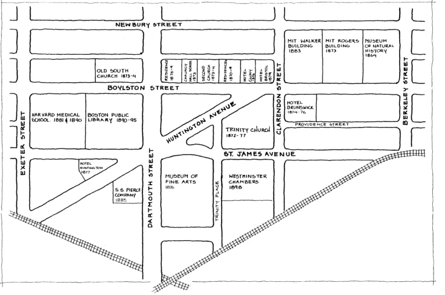
The focus of this portion of the study is on how the square was originated and formed, and the events which have shaped and changed it over a period of one hundred years.
- Developing criteria for the evaluation of proposals to redesign Copley Square. The criteria are developed based on observations and analysis of the square and its surroundings.
- Evaluating the two competition programs and winning designs which redesigned Copley Square in 1965 and 1984.
- Discussing the process of this study and its underlying theme, which also outlines an approach for the revitalization of urban
squares in general.
Thesis Supervisor: William L. Porter Title: Professor of Architecture and Planning
CONTENTS
Page
INTRODUCTION 13
PART ONE: HISTORY 23
CHAPTER ONE: Origins of Copley Square 25
CHAPTER TWO: 1860-1900 33
CHAPTER THREE: 1900-65 57
CHAPTER FOUR: 1965-84 64
PART TWO: OBSERVATIONS AND CRITERIA 77
INTRODUCTION 79
CHAPTER FIVE: Historical Context 81
CHAPTER SIX: Local Context 91
CHAPTER SEVEN: In the Context of Boston 105
PART THREE: EVALUATIONS 113
INTRODUCTION 115
CHAPTER EIGHT: The 1965 Competition 117
CHAPTER NINE: The 1984 Competition 125
PART FOUR: SUMMARY AND CONCLUSION 135
SUMMARY 137
CONCLUSION 145
APPENDIX A 155
APPENDIX B 157
6
LIST OF ILLUSTRATIONS
Page
Figure 1: The Back Bay and its neighbors. 14
Figure 2: East of the Back Bay; Public Garden, Beacon Hill and the 16 Central Business District.
Figure 3: The Back Bay and its northern limit, the Charles River. 18
Figure 4: Copley Place and the South End. 20
Figure 5a: The meeting point of the two grid systems. 24 Figure 5b: The area that later came to be known as Copley Square. 24 Figure 6: The proposed Conservatory of Arts and Sciences, designed by 26 William Waude.
source: Walter Muir Whitehill, Boston: A Topographical History.
Cambridge, MA. The Belknap Press of Harvard University Press. 1968. p.157.
Figure 7: The Public Garden, from Beacon Street, Arlington Street at 26
right, ca. 1880.
source: The Museum of Fine Arts, Back Bay Boston: The City as A Work of Art. Boston, MA. 1969. p.43.
Figure 8: General Plan for enlarging and improving the City of Boston, 28
proposed by Robert F. Gourlay, 1844.
source: Museum of Fine Arts, Op. Cit. p.41.
Figure 9: David Sear's plan for for Back Bay Development. 30
source: Walter Muir Whitehill, Op. Cit. p.150.
Figure 10: The filling of the Back Bay. 34
source: Museum of Fine Arts, Op. Cit. p.37.
Figure 11: Building activity in the Back Bay between 1845 and 1917. 34 source: Bainbridge Bunting, Houses of Boston's Back Bay. The
Belknap Press of Harvard University Press. Cambridge, MA. 1967. p.5.
Figure 12: The MIT Rogers Building, Boylston Street, 1872. Architect: 36
W.G. Preston.
Figure 13: The Museum of Natural History, Boylston Street, 1864. 36 Architect: W.G. Preston.
source: Rachel Johnston Homer, editor. The Legacy of Josiah Johnson Hawes: 19th Century Photographs of Boston. Barre Publishers, Barre, MA. 1972. p.56.
Figure 14: The Peace Jubilee Coliseum, 1872. Exterior and interiors. 38 source: Walter Muir Whitehill. Op. Cit. p.171.
Figure 15: Trinity Church, designed by H.H. Richardson, 1874, and 40 Copley Square, showing the Bristol Hotel apartments. the MIT Rogers
Building, and the Museum of Natural History, on the left.
source: Marjorie Drake Ross, The Book of Boston: The Victorian Period. Hastings House Publishers, New York, N.Y. 1964. p.129.
Figure 16: The Museum of Fine Arts, 1871-1876. Architects: Sturgis 40 and Brigham.
source: Museum of Fine Arts. Op. Cit. p.70.
Figure 17: Trinity Church from Boylston Street, ca. 1903. Museum of 42 Fine Arts on the far right, and Westminster Chambers in the middle.
source: Peter Vanderwarker. Op. Cit. p.8.
Figure 18: New Old South Church ca. 1900. Architects: Cummings and 44
Sears.
source: Peter Vanderwarker. Op. Cit. p.16.
Figure 19: Copley Square and the Back Bay in 1882. 46 source: The City At/as of Boston, G.M. Hopkins, Philadelphia, PA.
1882.
Figure 20a: Street pattern before land for Copley Square was 48 consolidated, 1880.
Figure 20b: Street pattern after the land was consolidated, 1882. 48
Figure 21: Copley Square area in 1905 50
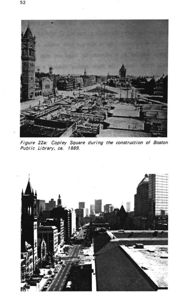
Figure 22a: Copley Square during the construction of Boston Public 52 Library, ca. 1889.
source: Peter Vanderwarker. Op. Cit. p.12
Figure 22b: Copley Square in 1979, showing roofs of the original Boston 52 Public Library, and the annex building.
source: Peter Vanderwarker. Op. Cit. p.13.
Figure 23: Boston Public Library, ca. 1905. Architects: McKim, Mead, 54
and White.
source: Museum of Fine Arts. Op. Cit. p.117.
Figure 24: Copley Plaza Hotel, photographed from the entrance of 59
8
Figure 25: The Bonwit Teller (formerly the Museum of Natural History) 59
on the left, and the New England Mutual Life Insurance Company on the right, photographed in 1984.
Figure 26: S.S. Pierce building on the southwest corner of Copley 62 Square, before it was demolished in 1958.
source: Walter Muir Whitehill. Op. Cit. p.196.
Figure 27: Southwest corner of Copley Square after the S.S. Pierce 62 building was demolished.
source: Walter Muir Whitehill. Op. Cit. p.223.
Figure 28: Proposal for the beautification of Copley Square. 65 Bird's eye view of projected plan. Architects: McKim, Mead, and
White, ca. 1900
source: Museum of Fine Arts. Op. Cit. p.59.
Figure 29: Copley Square as rearranged, in the "Boston Transcript," 65 October 26, 1912. Architect- Frank Bourne.
source: Ibid, p.59.
Figure 30: Aerial view of the "insurance district" showing Copley Square 67 and the 34-story John Hancock Tower in the 1950s. This was the tallest
building in the Back Bay before the Prudential Tower and the new 790-foot Hancock Tower was built.
source: Walter Muir Whitehill. Op. Cit. p.190.
Figure 31: Copley Square ca. 1970, after the implementation of the 67 Sasaki, Dawson, and DeMay design. View from Boston Public Library.
source: Institute of Contemporary Art, Boston: Forty Years of Modern Architecture, Boston, MA. p.37.
Figure 32: Copley Square and the Hancock Tower in 1984. 69 Figure 33: Boston Public Library. Left: original building by McKim, 71 Mead, and White. Right: annex by Philip Johnson. In the background
is the 790-foot Hancock Tower under construction. source: Institute of Contemporary Art, Op. Cit. p.17.
Figure 34: Map showing the site vacated by the S.S. Pierce building, 73
and the Massachusetts Turnpike Air Rights site.
Figure 35: Map showing Copley Place on the S.S. Pierce building and 73
the Massachusetts Turnpike Air Rights sites.
Figure 36: Copley Place viewed from the southwest corner of Copley 75
Square.
Figure 37: Dock Square/Fanueil Hall/Quincy Market. 82 source: Rendering by Benjamin Thompson Associates.
Figure 38: Christian Science Church Center. 84 source: Walter Muir Whitehill. Op. Cit. p.229.
Figure 39: Louisberg Square in 1984 84
Figure 40: Government Center Plaza 86
source: Institute of- Contemporary Art, Op. Cit. p.11
Figure 41: The historic buildings emphasized 88
Figure 42: The old street pattern 88
Figure 43: An analytical diagram of the enclosure of Copley Square. 92 Darker areas show greater sense of enclosure.
Figure 44a: The space self-contained 94
Figure 44b: The space directed 94
Figure 44c: The space centered 94
Figure 45: Facades of Boylston Street facing Copley Square, 1984. 96
Figure 46: Wind movement in Copley Square 98
Source: The Boston Redevelopment Authority
Figure 47: Shading on Copley Square 100
source: Ibid.
Figure 48: Franklin Court, Independence National Park, Philadelphia, 102 PA. Architects: Venturi and Rauch Associates.
source: Progressive Architecture, April, 1976. p.69.
Figure 49: Edge activities of Copley Square 104
Figure 50: Some of the major public open spaces of Boston 106
Figure 51: Streets which connect some public open spaces in Boston 108
Figure 52: The plaza could "spill" into the streets 108 Figure 53: Model of the Sasaki, Dawson, and DeMay design which won 114 the 1965 competition
source: Museum of Fine Arts. Op. Cit.
Figure 54: The Copley Square area before the 1965 competition 116 Figure 55: Sketches for the 1965 competition proposal by Sasaki. 116 Dawson, and DeMay.
Figure 56: First stage entry by Dean Abbot for the 1984 Copley Square 124 Competition.
10
Figure 57: Accompanying sketches with first stage entry by Dean Abbot 126 Figure 58: The final and winning design of the 1984 Copley Square 128 Competition by Dean Abbot.
Figure 59: The proposal by the SWA Group for the 1984 Copley 140 Square Competition. This was one of the five finalists for the second
stage of the competition.
Figure 60: The Campo in Siena 148
Figure 61: The Government Center Plaza in Boston 148 Figure 62: Ground Plan: City of Artificial Excavation 152 source: Architectural Design, number 53, 1/2-1983. p.91
Figure 63: Perspective view: City of Artificial Excavation 152 source: Ibid. p.92.
ACKNOWLEDGEMENTS
I would like to express my gratitude to the following persons without whose help this study would not have been possible:
Professor William L. Porter, for his encouragement, guidance, and criticism from the beginning to the end of this study.
To all the wonderful people in Rotch Library at M.I.T., for their cooperation and help in locating resources, not only from the library, but also from their personal collections.
And last, but not least, Maria, for her constant support and encouragement, and invaluable editing
14
The area that in 1883 was named Copley Square, in memory of the favorite local
painter who had migrated to England
--
John Singleton Copley, is located at the
meeting point of the Back Bay grid and the South End grid. Both grids, laid out on
reclaimed land in the mid-nineteenth century, are today known as very remarkable
examples of American urban design. The more important of these two grids was the
Back Bay(1) which extended from the land west of the Public Garden over the tidal
flats of the Charles River Bay. Similar to the rest of Boston's Back Bay, Copley
Square was under water when Boston was founded in 1630. It was not until the 1860s
when the city of Boston, responding to the demand for more space, filled in the
marshy fens to form one of the first neighborhoods.
The draining, filling, and building up of the Back Bay marked a turning point in
Boston's existence. The self-contained provincial town with its mainly English ancestry
and background, turned into a multinational metropolis reaching out far beyond New
England for cultural sustenance, and included within its new metropolitan framework
many other historically independent communities, such as Lexington and Concord. The
Back Bay, according to Lewis Mumford (1969), is a geographic area, and a cultural
(1) While the Back Bay went on to be a cultural, religious 'and educational center, as
well as being a residential district, the South* End remained as a residential
neighborhood.
16
Figure 2: East of the Back Bay; Pub/ic Garden, Beacon Hill and the Central Business District.
symbol; there are moments when the Back Bay might also be identified as a state of mind. Its topographical outlines, however, are fairly easy to delimit: it is the area that begins with the Public Gardens on the east, and terminates at Fenway Park on the West, while the South End and the Charles River Form the other two boundaries. The dominant axis of this whole area is Commonwealth Avenue; designed in the 1850s, it was one of the first American boulevards to be actually built. While it was contemporaneous with the tree lined avenues that Haussmann was creating in Paris, it is not really an imitation.
Copley Square began to stumble into shape when a group of business and professional men, and city employees started formulating ideas to enhance the market value and quality of the site for the benefit of the Commonwealth of Massachusetts. The first group, known as the "Committee of Associated Institutions," proposed a Conservatory of Arts and Sciences. The second group, the city employees, proposed to reserve land in the Copley Square area for use as a public park. The work of both these groups helped structure the formation of a unique square which became known for its cultural, religious, educational, and commercial surroundings.
In the decade and a half after its creation, Copley Square was regarded aptly as a very prominent civic place. It was surrounded by: Trinity Church, Boston Public Library, Museum of Natural History, Museum of Fine Arts, Massachusetts Institute of Technology, Harvard Medical School, and several other prominent churches. But the very success of Copley Square became the reason for its decline. By virtue of the presence of such prominent public institutions, the area was built-up quite quickly, and the land values increased considerably. When it was time for the public institutions to expand, not only was there a shortage of land, but whatever was available was quite expensive in comparison to some other parts of the city. Thus began a steady migration of the public institutions from Copley Square, which also caused a very
18
Figure 3: The Back Bay and its northern limit, the Charles River. The tree lined street is Commonwealth Avenue.
noticeable decline of the area. This decline continued until 1965, when Boston Mayor John F. Collins announced a competition to redesign Copley Square. This design, still in existence after its completion in 1970, was subject to rapid changes which occurred all around it. In 1983, one hundred years after its establishment, once again it was decided that Copley Square should be redesigned; in order to address "different needs, uses, and concerns in the changing and varying conditions of its borders".(1) Taking its name from the fact that the square was a hundred years old, the Centennial Committee was formed. This organization (composed of architects, urban designers, local citizens, businessmen, developers, and lawyers), gathered information, held workshops and meetings, heard debates, and finally came up with a program, along with the Boston Redevelopment Authority, to redesign Copley Square.
By the time this study had been completed, the final winner of the competition was also declared. Although this study has not been able to impact the competition, it now has the opportunity to evaluate the 1965 and 1984 competitions, and develop a good information base; should there be a third competition, this study could be a very useful document. This study, however, is not merely an information base for the redesign of Copley Square alone, it also deals with interventions on Copley Square's surroundings. It attempts to provide a holistic representation of the square and its surroundings, the assumption being that, to realize the full potential of Copley Square,
the square, as well as its environment, has to be revitalized.
Part One of the study deals with the history of Copley Square: its origins, the underlying goals for its creation, and the events which affected its character and role. The objective of the historical background is to understand the significance of Copley Square in Boston, and confirm the fact that the square's edge conditions were a major
(1) Boston Redevelopment Authority. Copley Square: Competition Ru/es and Regulations, 1983. p.3.
20
factor for its rise and decline. Photographs and maps are included to help the reader visualize the illustrious past and changing edge conditions.
The second part of the study documents the observations and analysis of Copley Square and its surroundings. What should be the character and role of Copley Square? Can its spatial quality be improved? How can the visual perception of the square be enhanced, and is there a good management strategy? These issues are discussed, and ways to deal with the problems are also suggested. Based on these discussions, criteria which address the above mentioned issues are formulated.
The criteria developed in Part Two are then used in Part Three to evaluate the two competitions for redesigning Copley Square. Each criterion is posed as a question, f or example: Were the historic buildings emphasized? Did the program state such a criterion? Both the competition program and its winning design are evaluated with respect to each criterion. To what degree does the design satisfy the criterion? Not all the criterion were applicable to the designs, because neither of the two competition programs include all the criteria in my list. This allows the reader to assess what has been done so far, and what needs to be done in the future to realize the full potential of Copley Square.
Finally, in Part Four, the two evaluations are summarized, and are followed by some concluding remarks. The conclusion describes the process of this study, the method, and its underlying theme in relation to preservation and revitalization of historic urban squares. As it will be discussed in the conclusion, this study began with a few "false" starts, the lessons learned from these "false" starts are mentioned in the conclusion. The last paragraphs of the conclusion pose some questions with respect to time and place. an issue which I have not been able to yet resolve. They are issues which deserve further research and study.
24
COMMOWVJECLARE AE
AUNTINGTON AVE
OU-ENDGRIO
LTON ApRoE -PA KTMOVTd -r.
RAILF-OAD LL~J~
-II L$Th6W00D A\f
Figure 5a: The meeting point of the two grid systems
Eio'tLTON 5T PKOVIDENCE 5T. 5T. JA MES AVE. HUNTIWGTON AVf CLARENDOW ST DARTMOUT 5T. TRINITY PLACe
CHAPTER ONE: ORIGINS OF COPLEY SQUARE
The Copley Square we know today has its origins in a deliberate and conscious effort to create a cultural and educational center together with the effort to create a public park in that area. As a 'esult of planned events, and some fortunate unplanned events, an urban square was established which was located at the meeting point of two grid systems (the South End grid and the Back Bay grid). The idea of a cultural center was not an instant idea; Boston was rapidly becoming one of the leaders in arts and music in the United States around that time (1859) when the first proposal to create a Conservatory of Arts and Sciences was submitted.
Bainbridge Bunting (1967) in his accounts of the cultural background of the Back Bay says that the 1840s and '50s saw the establishment of three associations of artists, founded, among other things, to organize yearly painting exhibits; in 1847 the new theatre, the Boston Museum, was provided with a large permanent collection of old, if somewhat questionable, masters. In 1850, the Athenaeum, settled in its new home on Beacon Street, devoted its entire third floor to a gallery for sculpture and painting. The fifties brought foreign picture dealers to Boston with stocks of modern French paintings which they sold at substantial prices; by the sixties and seventies several Boston artists travelled abroad to make purchases for Boston collectors at European sales. "This developing interest in art culminated in 1871," says Bunting, "in the founding of the long projected Museum of Fine Arts." The forties and fifties also
26
Figure 6: The proposed Conservatory of Arts and Sciences, designed by William Waude.
Figure 7: The Public Garden, from Beacon Street, Arlington Street at right, ca. 1880
I M9, Aft lk Iwo P.-W
saw a pronounced, almost sudden development of musical interest too. Boston had its first season of opera in 1847...."(1)
Thus, it was not surprising when in 1859 a group of business and professional people formed an informal organization known as the Committee of Associated Institutions, and submitted the first Memorial plan. This Memorial plan was the first of the three in which the Committee proposed the construction of a Massachusetts Conservatory of Arts and Sciences in the Back Bay. Several factors contributed to the conception of such a space. First, Boston had awakened from a slumber and was growing fast, economically as well as culturally. The long list of civic improvements and new institutions since 1850 bear witness to this fact. Second, Governor Nathaniel Banks in
1859 declared in the annual message of the legislature that land in the Back Bay
would be granted for educational improvements, "to keep the name of the Commonwealth forever green in the memory of her children."(2) Third, there was a notion in the mid-nineteenth century that the ideal public environment was the development of public spaces which included parks, parkways, and institutions devoted
to the study of history, science and art.(3) Albert Fein says that this concept of the ideal environment containing parks and public institutions remains today as America's most significant contribution to nineteenth century urban design. The concept, adds Fein, was no less important to the United States as an expression of cultural identity than was the Acropolis to Athens, the forum and baths to Rome. or the cathedral to
(1) Bainbridge Bunting, Houses of Boston's Back Bay. The Belknap Press of Harvard University Press. Cambridge, MA. 1967. p.13.
(2) Doreve Nicholaeff, The Planning and Development of Copley Square. MIT Department of Architecture Master's Thesis. 1979. p.9.
(3) Albert Fein, "The American City: Ideal and the Real." from The Rise of an American Architecture, edited by Edgar Kaufman Jr. Praeger Publishers, New York, N.Y. 1970. p.51.
28
GEN E RAt PLAN
p'on
11 11X1NN
&wtow 11 1'WI6 fImCITY
OF
BOSTO N.
New Towit,A' t, tv w it _______ _
Figure 8: General Plan for enlarging and improving the City of Boston, proposed by Robert F. Gourlay, 1844
medieval France. The underlying assumption was that such an environment would dramatically alter social values and lifestyle of a changing city.
So it was no great surprise that the first Memorial plan of 1859 proposed to construct a cruciform building which contained the following four sections:(1)
1. Societies devoted to Agriculture, Horticulture, and Pomology, and which would display the implements and models.
2. Societies devoted to Natural History and Practical Geology, and which would provide museums of specimens.
3. Societies devoted to Mechanics, Manufacturers, and Commerce. 4. Societies devoted to Fine Arts and the History of the Human Race.
The cruciform building designed by William Waude was proposed to be located in the Public Gardens. This location was probably influenced by what Fein described as a mid-nineteenth century American concept and a precedent -- the Crystal Palace in England. The proposed conservatory was to be made in iron and located in a park, the same as the Crystal Palace.
The building was never constructed; the Act of 1849, Chapter 210 had already proclaimed that no building save a City Hall may be erected between Charles and Arlington Streets.(2) With the failure of the Memorial of 1859, William Barton Rogers (the founder of MIT) was requested by the members of the Committee to present another Memorial in 1860 which also was denied by the Legislature. In 1861, a more thorough and realistic proposal was made, in which a specific site was also mentioned: the section lying west of Clarendon Street between Newbury and Boylston Streets. In
(1) Life and Letters of William Barton Rogers. MIT Museum, Cambridge, MA.
p.10.
(2) Walter Muir Whitehill, Boston: A Topographical History. The Belknap Press of Harvard University Press, Cambridge, MA. 1968. p.156.
30
this proposal, a petition was also made to establish the Massachusetts Institute of Technology as a part of the Conservatory. The land was granted in which two sections of the Conservatory were to be built. One-third of the block was given to the Museum of Natural History, and the remaining two-thirds were given to the Massachusetts Institute of Technology.
Meanwhile, another group of people who were engineers and surveyors of the city had quite a different idea as to what was to be done in the area which was later in 1883 named Copley Square. Their concerns were geared more to public health and safety. Prior to the filling of the Back Bay, parts of it had been the city dump, where ashes and other refuse were thrown by tipcarts into the bay; wharf rats scampered in and out of the sea wall on the westerly side of the Public Garden, while a common sewer entered the bay at the present corner of Beacon and Arlington Streets.(1) Recognizing the unpropitious quality of the site and keeping consistently with the original goals for the area -- civic improvements of the Charles River Bay, they proposed a public urban space which was called St. James Park.(2) This idea, as in the case of the Memorial Plan, was not an instant creation either; precedents had already been set. Two solutions are worthy of mention since both of these solutions focused on a public park which would be located on the site where Copley Square came to be.
The first of these proposals was by a visiting Scotsman, Robert Fleming Gourlay, who in 1844 had proposed a grandiose and quite impractical solution intended for the improvement of the Back Bay. Walter Muir Whitehill (1968) says that this plan was based on a previous one that Gourlay had done for his native Edinburgh. He actually
(1) Walter Muir Whitehill, Op. Cit. p.145. For more details on this topic see Robert
M. Lawrence, Memoirs of a Happy Life, p.3. and A. S. Wheeler, Address on Boston, Fifty Years Since Delivered before the Commercial Club of Boston, November 21, 1896 (Boston, 1896), p.14.
32
submitted several proposals to the City of Boston, of which only one is left in a lithographed publication titled General P/an for Enlarging and Improving the City
of Boston, 1844. There were two foci in Gourlay's plan, one was the Circus Island centered on the crossing of the railroad tracks, and the other was the "Elysian Fields" on the intersection of what was then Dartmouth and Boylston Streets. The Elysian Fields, designated as a park, is today the approximate site of Copley Square.
The second proposal was by David Sears who had actually owned a number of mudflats in the Back Bay. This proposal of 1849 suggested filling the mudflats but leaving a 75-acre oval shaped "Silver Lake" in the center to secure the supposed sanitary benefits of fresh air passing over the water. Boylston Street, in this plan, would lead to the center of the eastern shore of the lake, while a new Sears Avenue would run south of it in the region of St. James Avenue.
The unrealized St. James Park went through several changes in size, shape and orientation in its planning stages, but it always stayed around the area we today know as Copley Square. The plan of 1863 showed St. James Park oriented toward Boylston Street. Its long axis paralelled Dartmouth Street, thereby reinforcing its prominence. This was to be the final vision for a park at the southern boundary of the area that 20 years later was proposed as a square.(1)
CHAPTER TWO: 1860-1900
1860-70
The years between 1860 and 1870 saw the Back Bay very rapidly becoming an integral part of the enlarged hub of Boston. According to Bunting (1967) a record number of houses were built in 1870. The land filling operations which were influenced by the geometrical nature of each grid had followed two distinctive patterns. Initially it was a process of fill and build; after each block was filled the owners would come and build on their properties. But this sequential fill and build stopped when it reached the Copley Square area, from then on no more building was allowed until all the land was available by filling. The Back Bay had now also become a state of mind; it was being envisioned as the factor which would transform Boston from a provincial town to a great metropolis. Special emphasis was being given to its cultural character, which removed the issue of visualizing the new community as a viable self-supporting one. By 1870, there were four churches and two public buildings. The four churches which were built by 1870 are:
1860 Arlington Street Church, Architect: Arthur Gilman 1862 Emmanuel Church, Architect: A.R. Estey
1866 Central Church, Architect: R.M. Upjohn 1867 First Church, Architects: Ware and van Brunt
34
The Back Bay in 1836
1806 Map of Boston superimposed in white on 1969 map of Boston
Figure 10: The filing of the Back Bay
Fill basically complete, 1888
0 I n, E z 90---- -80 -- -- - --- --70 - - - --60 - -50 - - - 40-30 -- l --20 - -10 1 10 (U
The Back Bay in 1861
Extent of fill in 1871
Figure 11: Building activity in the Back Bay between 1845 and 1917
7
M
1863 also saw the St. James Park (later named Copley Square) being located on what Doreve Nicholaeff (1979) has called the "collision" of the two grid systems. The St. James Park was now located on the intersection of Boylston Street, Huntington and St. James Avenues, bounded by Dartmouth and Clarendon Streets. The park as envisioned by the second group (engineers and surveyors) would not only be an urban design achievement but also increased the land value of the area. The location of St. James Park on the collision of the two grid systems was also a celebration of an event: the meeting point of two land-filled areas which would push Boston from being a provincial town to a metropolis.
In the same year, two public buildings were built in the Copley Square area which started a trend of public buildings in that area until the early 1900s. The first of these two was the Museum of Natural History designed by W.G. Preston. The two-story red brick building was started in 1863 and finished in 1864. In 1963, this building was taken over by Bonwit Teller, a fashionable ladies' apparel store. The rest of the site on which the Museum of Natural History was built was given to MIT (incorporated in the Memorial Plan of 1861). The first MIT building, named after its founder William Barton Rogers, was also designed by W.G. Preston. Whitehill (1968) observes that the building was in felicitous relation to its neighbor -- the Museum of Natural History. The Rogers building was completed in 1872. This set a precedent which was followed by a number of public institutions in the Back Bay, especially around Copley Square.
An event which today remains as a landmark in Boston's musical history happened in the years between 1869-1872. Although it was a temporary event, its sheer magnitude and glory made Copley Square a well-known area. P.S. Gilmore, a reputedly passionate and persuasive music promoter talked his fellow citizens and patrons into constructing a temporary coliseum in which a National Peace Jubilee was held in June
36
Figure 12: The MIT Rogers Building, Boylston Street, 1872.
Architect: W.G. Preston
Figure 13: The Museum of Natural History, Boylston Street, 1864. Architect: W.G. Preston
1869. The structure was located on the site which today is occupied by Copley Plaza Hotel. The single performance of June 17, 1809, favored by the presence of President Ullyses S. Grant, was an incredible experience for those who were present. Says Whitehill (1968):
Witness, for a single example, the performance on 17 June, 1869 of the Anvil Chorus for // Trovatore by an orchestra of one thousand musicians, a chorus of ten thousand singers, supplemented by an organ, drum corps, the ringing of church bells and the firing of cannon (electrically controlled from the platform), and one hundred Boston
firemen beating rhythmically upon anvils with sledgehammers."(1)
A similar International Peace Jubilee was held in June of 1872 to celebrate the conclusion of the Franco-Prussian War. Composer Johann Sebastian Strauss travelled all the way to Copley Square (still unnamed) to conduct his own music. The finances of this second effort went into a deficit from which it never recovered. The coliseum never appeared again, and its place was taken by the Museum of Fine Arts.
1870-80
The Back Bay had already become an integral part of Boston, and was establishing itself as one of the centers of the world of culture in arts and sciences. Here, characteristically, Mrs. Jack Gardner, a newcomer from New York, assembled in her palatial domestic museum the arts of the Renaissance, hitherto largely known only through prints. Here, assiduous collectors such as Ernest F. Fevollosa, brought back the marvels of Oriental art now in the Museum of Fine Arts; it was here that the fresh world of color opened up by the French Impressionists was displayed long before either the Metropolitan Museum or the Chicago Art Institute were in a position to show similar work. So it is not a surprise that Harvard's rejuvenation in
38
The Peace Jubilee Coliseum, 1872.
science and scholarship under Charles Eliot coincided with the constructive enterprises of the Back Bay which ran from 1870-1900.(1)
Not only was there a rush of private residences of great quality and stylization, but also a series of public buildings started, the first of which was the Museum of Fine Arts. The commission for the design of this building went to Sturgis and Brigham after they were declared winners in a national competition. This building which occupied the site where Copley Plaza Hotel now stands was not merely a symbolic contribution to the area later known as Copley Square, but was also the first of the "walls" which would define the Square. The longer and main facade of the building faced the would-be Copley Square. It is said that Bostonians who were supposed to be very conservative never really liked the building. Whitehill (1968) says it was "one of those striped red brick and terra cotta Victorian Gothic structures that makes one wish that John Ruskin never visited Italy."(2) In 1876, the function of the Museum was extended from being a gallery and storehouse when a Museum School was launched as an adjunct of the new art. museum. Today this school, located in the Fenway, is known to be one of the better art schools of Boston. The establishment of the school coincided with the opening of the new building in Copley Square.
While the Museum was being built, there was talk of forming an "Art Square" on the site which later became Copley Square. This is documented in an article of the 1878 edition of Boston /Ilustrated. The article read:
(1) Lewis Mumford, The Significance of Back Bay Boston. An essay in the Museum of Fine Arts publication titled Back Bay Boston: The City as a Work of Art. 1969. p.29. Mumford presents a case in essay form for the historic preservation of Back Bay.
40
Figure 15: Trinity Church, designed by H.H. Copley Square, showing the Bristol Hotel apart Building, and the Museum of Natural History, on
Figure 16: The Museum of Fine Arts, 1871-1876. Architects: Sturgis and Brigham.
Richardson, 1874, and
ments, the MIT Rogers the left.
The main front is already finished, and faces Art Square, with a projecting portico in the center, enriched with polished marble of columns. The right wing is adorned with a great bas-relief representing Art receiving the tribute of all nations: and the left wing is to have a companion piece, illustrating the union of Art and Industry.(1)
The next important public building which contributed to Copley Square's cultural image and spatial formation was Trinity Church. In June 1872. Trinity Church under the rectorship of Phillips Brooks, bought the triangular section of land on the Copley Site. bounded by Huntington Avenue, Providence and Clarendon Streets, consolidating it with a previous purchase (the rectangular piece bounded by Providence and Clarendon Streets, and St. James and Huntington Avenues), and formed the site for Trinity Church. The church designed by H.H. Richardson is now recognized as a masterpiece. in American architecture. This building, which today is also a reminder of the road pattern in which Huntington Avenue bisected Copley Square, had achieved national importance even before it was completed. An article appeared in the American Architect and Building News (1876), which attested to the prominence of Trinity
Church in New England.
The new Trinity Church in Boston, the most important church thus far built in New England, except perhaps its neighbor, the new Old South Church. is nearly finished. The interior decoration, which is already in hand, is a noteworthy undertaking, for it is one of the instances in which there has been a serious attempt among us to decorate a church with mural paintings: and it is the first instance we believe, when the whole decoration has been put under the direction of an artist of distinction, to be carried out by himself and his fellow artists, with the object of bringing the whole work -- general colour, decorative detail and figures -- into a consistant harmonious whole. The work is planned and directed by Mr. La Farage, who will himself paint some of the figure-subjects .... (2)
(1) Boston Illustrated. 1878 ed. p.52.
(2) American Architect and Building News. volume 1. Oct. 28, 1876. p.345.
42
I
Figure 17: Trinity Church from Boy/ston Street, ca. 1903. Museum of Fine Arts far right, and Westminster Chambers
This great building, says Whitehill (1968), blends the Romanesque masses of Auvergne with the Torre del Ga//o of Salamanca, and Portal of SL Gillen to provide the exterior for an auditorium capable of accomodating Phillips Brooks and his devoted
followers. The church was consecrated on February 9, 1877.
The third important development of public buildings was actually the construction of two separate buildings. Both of these buildings were constructed on Boylston Street directly opposite to the Museum of Fine Arts. Thus the formation of the third wall of Copley Square was on the way. The first building was Chauncy Hall School finished in 1873, designed by A.C. Martin. This school which covered three Back Bay lots was also known to be one of the most prestigious private schools in Boston. The pre-existence of MIT probably influenced the location of this school. Many students who graduated from this school went on to continue their education at the neighboring MIT. This school was partially destroyed by a fire in the early 20th century, and was never rebuilt.
Next to the school was built a church which was finished in 1875. Designed by N.J. Bradlee, this spireless church occupied five Back Bay lots. Along with private residences and two other hotels, Hotel Bristol (1879), and Hotel Cluny (1876) the third wall, standing on Boylston street was complete. While Chauncy Hall School and Second Church were being built, another important church was built on the corner of Boylston and Dartmouth Streets -- the new Old South Church. It boasted a striking campanile, designed by Cummings and Sears, in the North Italian Gothic style. Thus by 1880, Copley Square had the following public buildings in its immediate surroundings:
1. Museum of Natural History - 1864
44
3. Museum of Fine Arts - 1876 4. Trinity Church - 1877
5. Chauncy Hall School - 1873 6. Second Church - 1875
7. New Old South Church - 1875
In addition to these public buildings were some private residences and the following
hotels:
1. Hotel Cluny - 1870 2. Hotel Bristol - 1879 3. Hotel Huntington - 1877
Thus Copley Square was now an educational, cultural, religious and high-income
residential center. The square itself, however, was still a composite of fragmented
pieces of land bisected by Providence Street, Trinity Place and Huntington Avenue.
1880-83
In 1880, although three sides of the Copley site were fronted by prominent public
buildings, the city had not acted on making it a square. Land value which had
increased considerably around Copley Square was due to the existence of the several
public buildings. Prior to 1880 there were proposals for hotels and a Chemical
Institute on the pieces of land which later became Copley Square; fortunately these
proposals were never carried out, because as early as 1875, the Park Commissioners
had voiced an intention to create a public park around the area where the two grid
systems met. The land they believed would be St. James Park was the corner parcel
of Boylston and Dartmouth Streets, west of Huntington Avenue. Between 1880-83,
several incidents occurred which led to a change of plans in which St. James Park
cT~s
It
1VE
It
Figure 19: Copley Square and the Back Bay in 1882.
was forgotten and Copley Square established by consolidating the broken pieces of land which fronted Trinity Church. (see Figures 20a and 20b)
In 1880, the Trustees of the Boston Public Library received a grant of land bounded by Boylston, Dartmouth, and Providence Streets and St. James Avenue. Two years later Harvard Medical School moved to the Copley Square area, and built its facilities on the parcel next to the Boston Public Library, bounded by Exeter and Boylston Streets and St. James Avenue. In doing so, they also sealed their end of the alley called Providence Street. The city immediately acted, and sealed the rest of the alley. The Boston Public Library was now given additional land; the tiny triangular piece separated by Providence Street was joined to the trapezoidal section (see Figures 20a and 20b) thus creating a large triangular piece. The Harvard Medical School was completed in 1883, designed by Ware and van Brunt (who also designed Harvard University's Memorial Hall). This building substantially reinforced Copley Square's image as an educational center.
The time was ripe to create an urban square; three sides of the triangular piece of land were already fronted by very important public institutions, and a fourth side would soon be fronted by the Boston Public Library. Finally the city acted on its intentions to create a public open space and acquired the large triangular piece of land from the several owners on July 7, 1882. The city, however, did not buy the smaller triangle which was owned by the Boston Water Power Company. Then in 1883, the city consolidated all the land it had bought and named it Copley Square, after the favorite local painter, James Singleton Copley. On February 1, 1883, Mr. Whitney, a prominent businessman, bought the small triangle from the Boston Water Power Company for $25,000. In 1885, when he proposed to build a hotel there, the city azted immediately. They bought the land from Mr. Whitney for $30,000, thus saving
L-
I'I
__1L
~~%LJ~ £ ~ I ?7OOSF~ l-Q/ m9e>%zD CIIEH - 'tY L--j I' *J I
167BO L-AL TO72N
HAZvAgo INITIAL SITE1 M EDC co- FOR 6. P.L .
PROVIcE T. TRI NIT
-1 7CHURCH
ST. Z-AME5 AVE NWUE TWE O BMPAy
to 2
z z
Figure 20a: Street pattern before land for Copley Square was consolidated, 1880.
I-
o
AAP A~r)LAW NAMEID 9
A FINAL ZATE
cc
teqQMP-DICAL -- tACOL FO -P 83
1RUIT Fi ROVIDENe'.E ST
FL i 2
i
Figure 20b: Street pattern after the land was consolidated, 1882.
48
the facade of the Museum of Fine Arts and Trinity Church, which was voted to be the most beautiful building in the United States that year.(1)
1883-90
After Copley Square was named, a wave of apartment hotels were built in the area, probably anticipating the future increase of activity there. Hotel Huntington had already been built in 1878 in one of the south-west corner plots of Copley Square. Next came Hotel Oxford and Hotel Copley at the corner of Exeter Street. These hotels were considered to be the finest in Boston in 1885, and thus attracted only Social Registered citizens.(2) Thus Copley Square was now not only surrounded by educational, religious and cultural buildings, but also by the finest hotels in Boston.(3) The next important development which greatly affected Copley Square was the construction of the S.S. Pierce building. Wallace Pierce, the owner of the company had already built a store in Scollay Square (now renewed as Government Center Plaza) in 1884. Recognizing the potentials of the land he owned at the south-west corner of
(1) Doreve Nicholaeff. Op. Cit. p.69.
(2) Bacon's Dictionary
(3) Brainbridge Bunting in his book provides a very thorough list of all the important houses, and public and commercial buildings built in the Back Bay area. According to his list, the following hotels or apartment buildings were built between the years 1883-88 around Copley Square:
1. Hotel Oxford. Corner of Huntington and Exeter. 1883. Architect: Snell and Gregerson.
2. Hotel Copley. Near the corner of Huntington and Dartmouth. 1884. Architect: Fred Pope.
3. Hotel Aubry. On Dartmouth Street. 1880. Architects: W.G. Preston and A.C. Fauld.
4. Hotel Kensington. At the corner of Boylston and Exeter. 1884. Architect: J.L.
Faxon.
5. The Victoria (commercial hotel). At the corner of Dartmouth and Newbury Streets. 1884. Architect: J.L. Faxon.
6. Hotel Ludlow. At the corner of St. James Avenue and Clarendon Street. 1888. Architects: Walker and Best.
I
IL
._3
L
NEW-SURY fTREET]
OLD SOUTH[
9
i
J
I 4~.
~
~2 ~
I~i~~~aog-!0 m
-5L5ovTON 5TRE.T
]FHARVARD
MEIDICAL E50STON PU15LICamoL E IO8814 1eqo LIBRARY Iqo-q5 ld
w
I-0
Figure 21: Copley Square area in 1905
MIT WALKER MIT ROC-EP,5 NOUSEUM
BUILDING BUILOIN& OP NJTURAL
11673 H I 6ToRtf wh bJ LnT C0
I- ----
J L
Ilu
Copley Square at the intersection of Huntington Avenue and Dartmouth Street, Pierce built a massive brick building there. The building, according to Whitehill (1968) did not have much architectural significance, but its mass and pivot position helped define the enclosure of the square and set a reference for height and mass for a later building - the Boston Public Library. The Pierce building contained a store on the ground floor and a number of offices on upper floors. This was the first commercial building in the Copley Square area, and was a very successful one. It caught the attention of the Boylston Street property owners, who petitioned for and received release from the clause which proscribed commercial activities on that street.(1) The wave of commercial buildings that came after 1888 considerably changed Back Bay's domestic -and cultural image, and created some inconsistency in the architecture. The area most affected was Boylston Street which even today has not been able to achieve a level of architecture that is somewhat compatible with the rest of the architecture around Copley Square. Lewis Mumford observes:
In the original plans for the Back Bay, domestic and cultural facilities were rightly considered the dominant needs, though perhaps too exclusively, for business activities were peremptorily relegated to the more disorderly older portions of the city, and when they were finally admitted, along Boylston and Newbury Streets, they carried with them some of their competitive disorder and officious self-advertisement.(2)
Construction of the Boston Public Library began in 1887, seven years after the land had been granted. The commission was given to McKim, Mead, and White.(3) Today this building is acknowledged as a masterpiece in American architecture. The building,
(1) Brainbridge Bunting, Op. Cit. p.483. (2) Lewis Mumford, Op. Cit. p.28.
(3) Originally a national competition was called in which a winner was selected. The winning design, however, was discarded because it supposedly did not achieve a level of design which was appropriate for such an important building. After this incident the Trustees decided to abandon the idea of a competition and awarded the commission to McKim, Mead, and White, who had achieved considerable prominence across the country for their work.
52
Figure 22a: Copley Square during the construction of Boston Public Library, ca. 1889.
Figure 22b: Copley Square in 1979, showing roofs of the original Boston Public Library, and the annex building.
modelled after the Paris Bibliotheque, is of the Italian Renaissance style, according to Bunting (1967); it may, however, also be seen as a product of the revival period of the classical style. Compared to Trinity Church, it is a much more conservative and quiet building. Fewer colors and facade elements are used in a repetitive and symmetrical composition. Its dignified facade began to act as a foil to the unchecked individualism of the preceding decades.(1) Whitehill (1968), states that Charles F. McKim, in planning the library must have taken into account the disparate masses offered by the Pierce building and by the Campanile of the new Old South Church.
1890-1900: THE RISE TO NATIONAL IMPORTANCE
Copley Square, within a decade and half of its creation, gained such prominence that it led to speculation all over the country. It was adverstised as a prestigious address by owners of commercial and private enterprises in the neighborhood in order to entice people to visit their buildings.(2) In addition to being a commercial, religious, educational and cultural center, Copley Square had also become a transportation hub -the streets around -the square were thronged with electric cars and horse carriages. Although being a transportation center brought more people to the square and increased its prominence, the traffic lanes also began to disunify the square from its surrounding buildings by the continuous stream of movement. The completion of the Boston Public Library in 1895 was probably the ultimate event which escalated Copley Square to national significance.
With the increased consciousness of people after the American victories in the Spanish-American wars, it was believed that a building ought to be the symbol of political or social value of Imperial America.
(1) Boston Society of Architects, Architecture Boston, Barre Publishing, Barre. MA.
1976. p.66.
54
i
Figure 23: Boston Public Library, ca. 1905. Architects: McKim, Mead, and White.
Celebrating symmetry and regularity as the solution to the facade on Dartmouth Street, the Library envisioned a future role for itself as such a symbol for the nation. In fact it came to be rated more significant than Trinity Church, and was voted the second most beautiful building in America, while Trinity Church had slipped to third place.(1)
Thus, Copley Square now had everyone's attention; it was considered a national space. In 1879, when the Westminster Chambers, a ten-story apartment house designed by H.A. Cragier exceeded the height limit of ninety feet (by six feet), opposition came from the Museum of Fine Art Trustees. They claimed the additional height rendered it difficult to view art works located beneath the skylights which were shadowed by the Westminster Chambers. Even before the Museum had objected, the American Architect and Building News had reacted while the Westminster Chambers was in proposal stage. Their concern was for Trinity Church, which they felt was being
injured by this new tall structure.
The admirers of the late H.H. Richardson's greatest work, Trinity Church, Boston, will be sorry to hear that plans have been made for a building, a ten-story apartment house which cannot but be greatly injured by the new structure. Presuming that the apartment house will be carried to the maximum height permitted by law in Boston, one hundred and twenty-five feet, its cornice will rise higher than the stone-work of the central tower of the church. It is hardly necessary
to point out how sadly the church will be dwarfed by the contrast.(2)
The Westminster Chambers was built only to a height of ninety-six feet,(3) to which the Museum of Fine Arts objected. In 1899, the Museum had transferred the ownership of the land to another party, and had dropped the charges. But the struggle
(1) Doreve Nicholaeff, Op. Cit. p.86. Although it seems that these comments were based on some documentation written around the turn of the century, Nicholaeff does not cite her sources. This is the second time in her thesis she has
mentioned a voting of some kind to select the most beautiful building in America, and has not cited her sources. I have assumed that this information must have a source, although I have not yet been able to locate it.
(2) The American Architect and Building News, Volume LVII, September 4,
1877. p.77.
(3) In the editorial of the American Architect and Building News, the height limit of one hundred and twenty-five feet mentioned was the height limit for other areas in Boston, the height limit for the Copley Square area was only ninety feet.
56
was continued by other concerned individuals and the city; finally af ter twenty-two years of debating, the Westminster Chamber was forced to remove two feet of roof and four feet of cornice.
Although Copley Square had achieved prominence as a center for the arts, religion, education and commerce, it had also become architecturally or visually less appealing. The intensity of traffic had led to a separation of the open space and its surrounding buildings, which prompted more discussions from concerned parties. The American Architect and Building News once again expressed its concern for Copley Square:
Copley Square, in Boston, is just now greatly attracting the attention of those interested in municipal improvement. Although, like nearly all the Boston "squares," it is at present really a compound, it is distinguished by being traversed by three important streets, through each of which many thousands of people are transported every day by several electric cars; and it is impossible to doubt that, before many years, it will become a very important business center, - probably the most important in the city, next to the area about the intersection of State and Congress Streets. The present condition of the square, as an object of artistic interest is simply lamentable. Two bare grass-plots, left, as it were, by an oversight, between the intersecting streets, constitute the ornamental portion of the area, and the appearance of fine buildings which surround it, including the Museum of Fine Arts, the Public Library, Trinity Church, and the new Old South Church, is sadly marred by the Huntington Avenue, which cuts diagonally across the foreground to all of them.(i)
The article in the American Architect and Building News went on to discuss possibilities of how to improve conditions. The apparent solution at that time seemed to be the suppressing of Huntington Avenue or rerouting it. Nothing came of the several suggestions (which will be discussed in Chapter Four of this thesis) until 1965, when the city of Boston announced a nationwide competition to redesign Copley Square.
(1) American Architect and Building News, Volume LVII, September 18,