Publisher’s version / Version de l'éditeur:
Vous avez des questions? Nous pouvons vous aider. Pour communiquer directement avec un auteur, consultez la première page de la revue dans laquelle son article a été publié afin de trouver ses coordonnées. Si vous n’arrivez pas à les repérer, communiquez avec nous à PublicationsArchive-ArchivesPublications@nrc-cnrc.gc.ca.
Questions? Contact the NRC Publications Archive team at
PublicationsArchive-ArchivesPublications@nrc-cnrc.gc.ca. If you wish to email the authors directly, please see the first page of the publication for their contact information.
https://publications-cnrc.canada.ca/fra/droits
L’accès à ce site Web et l’utilisation de son contenu sont assujettis aux conditions présentées dans le site LISEZ CES CONDITIONS ATTENTIVEMENT AVANT D’UTILISER CE SITE WEB.
Technical Memorandum (National Research Council of Canada. Division of
Building Research); Issue 79
READ THESE TERMS AND CONDITIONS CAREFULLY BEFORE USING THIS WEBSITE. https://nrc-publications.canada.ca/eng/copyright
NRC Publications Archive Record / Notice des Archives des publications du CNRC :
https://nrc-publications.canada.ca/eng/view/object/?id=5896e329-db6d-452f-bdfd-420b23a8fa04
https://publications-cnrc.canada.ca/fra/voir/objet/?id=5896e329-db6d-452f-bdfd-420b23a8fa04
NRC Publications Archive
Archives des publications du CNRC
This publication could be one of several versions: author’s original, accepted manuscript or the publisher’s version. / La version de cette publication peut être l’une des suivantes : la version prépublication de l’auteur, la version acceptée du manuscrit ou la version de l’éditeur.
Access and use of this website and the material on it are subject to the Terms and Conditions set forth at
Guide to a Field description of Permafrost for Engineering Purposes
NATIONAL RESEARCH COUNCIL CANADA
ASSOCIATE COMMITTEE ON SOIL AND SNOW MECHANICS
GUIDE
toeFIELD DESCRIPTION
ofPERMAFROST
for Enqineerinq Purposes ャ[GセB.
-)
Prepared by1.
A. Piblainen and G. H. JohnstonTechnical Memorandum 79
FOREWORD
Almost one hall of Canada's total land surface is underlain by permafrost and its existence has many implications to both scientific and engineering interests. Engineering experience has indicated that site investigations are essential in permafrost areas but no standard method for reporting permafrost conditions has been used or is available. This book-let has been prepared with the hope that the descrip-tive system outlined will fulfil this need.
The method for describing the ice phase in perennially frozen materials, which forms a major part of this "Guide", was originally developed by the Arctic Construction and Frost Effects Laboratory (now Cold Regions Research and Engineering Labora-tories) of the U.S. Corps of Engineers, with assistance from the Division of Building Research, National Re-search Council, Canada.Itis intended that the book-lets on Soils (Technical Memorandum 37) and Muskeg (Technical Memorandum 44) previously published by the Associate Committee on Soil and Snow Mechanics be used as companions to this Guide.
Comments and criticism regarding the usefulness of this suggested descriptive system for permafrost are encouraged and will be welcomed.
TABLE OF CONTENTS
Paqe
WHAT IS MEANT BY "PERMAFROST".. . . 5
BASIS OF THE DESCRIPTIVE SYSTEM. . . 5
SURFACE CHARACTERISTICS. . . 6
Veqetation Cover... . . . 6
Snow Cover. . . 6
Relief and Drainaqe. . . 6
SUBSURFACE CHARACTERISTICS... 7
Depth of Thaw.. . .. .. . . 7
Subsurface Materials... . . . 8
(1)
Soil
Phase.. . .. .. .. .. .. .. .. . . . .. . . . .. . 8(2) Ice Phase. . . 9
(A) Ice Not Visible. .. . .. .. . . .. . 9
(B)Visible Ice
<
1 inch Thick... . . .. 10(C)Visible Ice> 1 inch Thick.. .. . . . .. 10
FIELD INVESTIGATIONS AND RECORDS. . .. 11
TABLE I-ICE PHASE DESCRIPTIVE SYSTEM 12 TABLE ll-TERMINOLOGY. 18 APPENDIX A-TYPICAL DATA SHEETS ... 20
1. WHAT IS MEANT BY "PERMAFROST"
Permafrost is defined as the thermal condition under which earth materials exist at a temperature below 32°F continuously for a number of years. Thus, all earth materials including bedrock, gravel, sand, silt, peat or mixtures of these materials may exist in the perennially below 32°F condition. Permafrost is defined exclusively on the basis of temperature, irrespective of texture, degree of in. duration, water content or lithologic character.
The term "perennially frozen", although cumber-some, is generally used to describe specific peren-nially frozen materials, e.g. perenperen-nially frozen silt, perennially frozen organic material. The presence of ice is not a necessary requisite of permafrost, but when ice is present it is of particular significance to engineers.
The term permafrost can also be used to describe the areal extent of the below 32°F condition. It has been found convenient to divide the permafrost region into two major zones-the continuous and the discontinuous.In the continuous zone permafrost is found everywhere under the ground surface to considerable depth; in the discontinuous zone permafrost is not as thick and exists in combination with areas of unfrozen material.
z.
BASIS OF THE DESCRIPTIVE SYSTEMAlthough permafrost is defined on a temperature basis, temperature is not a convenient or easily measured property for field description purposes. A more convenient approach to the field description of permafrost is to describe terrain features that may influence the existence of permafrost. ObservatioJ1ll of terrain and the effects of construction on perma-frost in northern Canada have suggested the follow-ing specific features of terrain that are of interestto engineers: •
(1) Surface characteristics Vegetation cover Snow cover Relief and draiJlllge
(2) Subsurface characteristics Depth of thaw
Subsurface materials Soil phase Ice phase
Observations on these topics represent a minimum of field information that must be collected to describe permafrost adequately for an engineering appraisal of a site.
3. S1JRI'ACE CHARACTERISTICS
3.1 Vegetation Cover
The vegetative mantle of trees, shrubs, moss, lichen and other plants that covers much of the North acts as an insulator that protects and maintains permafrost. Vegetative coverisof additional interest in that it may indicate soil, ground water, wind and/or snow conditions. The major combinations of vegetation at a site should be delineated and de-scribed using the system outlined in the "Guide to a Field Description of Muskeg" (Technical Memo-randum 44) published by the Associate Committee on SoU and Snow Mechanics.
3.2 Snow Cover
Although snow is basically a part of the climate, snow cover is generally considered as a terrain factor. The presence of snow reduces the depth of seasonal frost penetration during the winter and conversely inhibits thawing of frozen material in the spring. The type of snow, the depth of snow cover and their variability over a site thxoughout the winter season should therefore be observed.
3.3 Relief and Drainage
Terrain relief influences permafrost occurrence and since it is also a significant factor in drainage it is an important engineering consideration. Regional relief features should be described in addition to those observed at specific locations under investiga-tion. Regional descriptions should include some in-dication of altitudes; whether the landscape is mountainous, hilly, undulating or flat; possible
origin of the landform; and the regional drainage pattern. At specific sites small scale or micro features of relief and drainage should be noted. These small scale features are difficultto classify for descriptive purposes but would include details of patterned ground (sorted or unsorted circles, nets, polygons, steps and stripes), micro-drainage, slope and expo-sure to solar radiation.
A photographic record of the various surface characteristics (e.g. showing typical vegetation and snow cover, and relief and drainage features) is
most valuable. A complete description of site condi-tions can be usefully summarized on a sketch map or air photograph of the area under investigation.
4. S1JBS11IlFACE CHARACTERISTICS
4.1 Depth of Thaw
The seasonal depth of thaw and its variability within an area and from yearto yearhaslong been recognized as an important engineering considera-tion in permafrost areas. The depth of thaw refersto that portion below the ground surface at a specific location that is thawed at some time during the course of a summer. It increases progreBBivelyduring the thawing season and therefore it is important to note the date on which a particular observation was made. When the seasonal thaw has reached its maximum depth (usually in the late fall) it then cor-responds to the"active layer". The "active layer" refers to the zone in which seasonal thawing and
freezing occurs.
The depth and rate of thaw are affected by and closely related to terrain features. Any variations in an area are usually the result of differences in surface conditions such as vegetation, relief, drainage and snow cover and may also be related to changes in subsurface materials.
Initially, depth of thaw observations should be made in areas having different surface covers and then extended to locations within these areas that have noticeable changes in relief, drainage or sub-surface materials. Appreciable differences in the
depth of thaw for an area as small as 5 feet square are possible. It is important therefore to make many random observations at a site and to record not only the average but also the mazimum and minimum depths of thaw for the area.
The depth of thaw can be conveniently measured using a probe that retains a sample of the thawed subsurface materials for examination. Records of the depth of thaw should also include notes on the date of observation, vegetation cover, relief, drainage, and a description of the subsurface materials in the various areas probed. Some assessment of the mois-ture content, density and ice segregation in the frozen soil underlying the thawed zone are of particular interest.
4.2 Subsurface Materials
The materials encountered in the frozen state vary, and can include bedrock, gravel, sand,silt, clay and organic material (peat). These frozen materials or combinations of them frequently contain consider-able quantities of ice. Important engineering impli-cations are involved when this condition occurs. It
is important, therefore, to examine not only thesoil but also the ice encountered in the soil. For engineer-ing purposes, it is convenient to describe the soil and ice phases independently. At times a description of frozen bedrock may be required.Itwill be noted in the following paragraphs that the ice description system is based on the form of ice in frozen materials and is therefore applicable for either soils or bedrock.
4.2.1 Soil phase
The description of the soil phase applies to mate-rials found in both the thawed and frozen states. Coarse- and fine-grained soils should be described according to the "Guide to a Field Description of Soils" (Technical Memorandum 37) published by the Associate Committee on Soil and Snow Mechanics. Partly organic soils, which are largely mineral types, are described as the predominant soil modified by the word "organic", e.g. organic silt. Soils that are mostly organic (peat), however, should be de-scribed according to the system outlined in "Guide
to a Field Description of Muskeg" (Technical Memo-randum 44).
4.2.2 Ice phase
The descriptive system for the ice phase is based on the formof ice found in frozen materials. It is not intended that this system be used to assess frozen materials according to properties or performance. For descriptive purposes frozen materials are divided into three major groups in which the ice is:
notvisibleby eye,
visibleby eye with individual ice layerslessthan 1 inch in thickness,
visibleby eye with individual ice layersgreater
than 1 inch in thickness.
The major ice phase descriptive groups and their subdivisions are summarized in Table 1. Letter symbols that suggest key descriptive terms of the ice forms for each subdivision have been included to help in the preparation of graphic logs or records. Written observations, however, are the fundamental feature of the descriptive system and the letter designations must be regarded only as a "short-hand" form. Guides for further descriptive details and illustrations of the basic types are included.It is not expected or intended that all of the detail shown in Table I should always be noted. In much engineer-ing work only the most fundamental details need be recorded. Some definitions to clarify terms used in
the ice phase descriptive system are given in Table II.
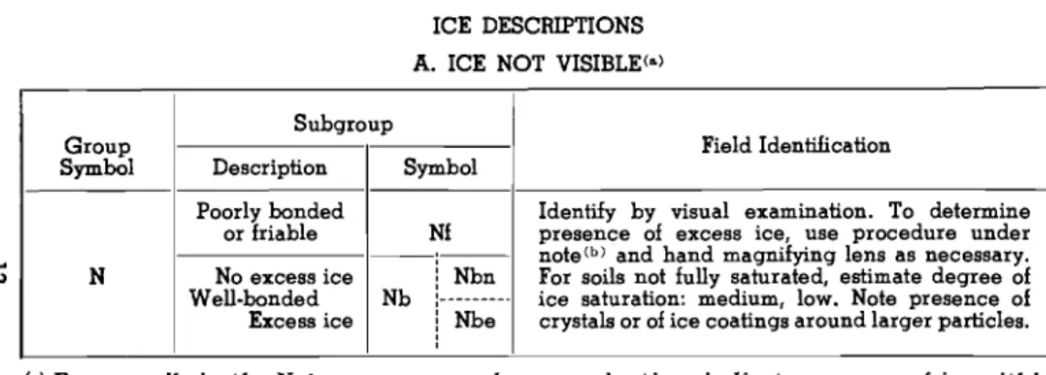
(A) Icenotvisible
When ice is not discernible by eye its effective-ness as a cementing agent in bonding the mineral or organic portion is used as a further subdivision:
(a) ice that bonds or cements the subsurface materials into aweak or friable mass,
(b) ice that bonds the subsurface material into a
hard, solid mass.
The presence of ice not generally discernible by eye may be revealed within the voids of the material by crystal reflections.or by a sheen on fractured or trimmed surfaces. The impression to the unaided eye
is that none of the frozen water occupies space in excess of the original voids in the soil. The opposite
is true of soils where the ice segregation is visible byeye.
In some cases, particularly in materials well bonded by ice, a large portionofthe material may actually be ice, even though itisnot discemible by eye. When visual methods are inadequate, a simple field test to aid evaluation of the volume of ell:Ce88 ice can be made by placing a chunkofthe material in a small jar, 'allowing it to thaw, and observing the CJUantity of water as a percentage of the total volume. If free water is noted itistermed "ell:C888".
(B) Visible ice segregation less than1 inch thick
When iceis discernible by eye andis1888 than 1 inch thick further subdivisionisbased on the form and orientation of the ice concentrations:
(a) individual ice crystals or inclusions, (b) ice coatings on particles,
(c) random or irregularly oriented ice formations, (d) stratified or distinctly oriented ice formations.
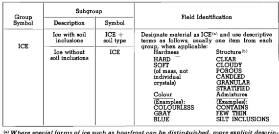
(C) Visible ice segregation greater than1 inch
thick
For descriptive purposes, ice formations qreater than 1 inch thick may be considered as ICE. Two types of ice strata are recognized at present:
(a) ice with soil inclusions, (b) ice without soil inclusions.
In some cases the occurrence of stratified or distinctly oriented ice formations in frozen soil in-creases to such an extent that the frozen material approaches "ice with silt lenses". Although the absence or inclusion of soil in ice is a first subdivision, the over-etl form of the ice mass should also be included. Common forms of such "massive ice" are:
random or irregularly oriented layers, vertical, wedge-shaped sheets, and variable chunks or blocks sometimes hundreds of square feet in area.
5. FIELD INVESTIGATIONS AND RECORDS
The scopeoffield investigations of permafrost and the amount and type of information required will depend largely upon the use for which itisintended. A discontinuity in the occurrence of permafrost (areas free of permafrost or large variations in the depth to permafrost) has many implications to con-struction. Accordingly, a sufficient number of ob-servations must be made at a site so that the areal occurrence of permafrostis adequately delineated. This is particularly important in the discontinuous zone where permafrost occurs in scattered patches or "islands" in combination with areas of thawed ground.
All information collected should be recorded on data sheets. Typical sheets of recorded information have been included. Most of the specific details required are noted; other pertinent information may be added.
Group Symbol
TABLE I ICE DESCRIPTIONS A. ICE NOT VISIBLE<a) Subgroup Description
I
Symbol Field Identification...
N N Poorly bonded or friable No excess ice Well·bonded Excess ice Nb Nfi
NbnゥMMn「MセMᄋ
Identify by visual examination. To determine presence of excess ice, use procedure under note(b) and hand magnifying lens as necessary. For soils not fully saturated, estimate degree of ice saturation: medium, low. Note presence of crystals or of ice coatings around larger particles. (a)Frozen soils in the N group may, on closeexamination, indicate presence oficewithin the voids of the material by crystalline reflections or bya sheen onfractured or trimmed surfaces. The impression received by the unaidedeye, however, is thatnoneof the frozen wateroccupies spaceinexcessof the original voids in the soil. The opposite is true of frozen soils in the V group (see p. 14).
(b)When visual methods maybeinadequate, a simple field testtoaid evaluation of volume
ofexcess ice can be made by placingsome frozen soil in a small jar, allowing it tomelt, and observing the quantity of supernatant water as a percentage of total volume.
.
..
セ セ I 0 .... .... u 0 -z..
0 ' " セ CD ' " Z ... u....
... xm
...
;J: :; 1LI•
...J セ en I > I....
W!.!...
Clu 0 ....-Z 0 " , c: セセ 1LI セ CDU U Z ... X...
0
..-i
.... 0 ..J ;J:Z (5 c,:)'"
....
0!I
....
0 Z.
...
0 CD Z セ a:: 0 0 CL.,
0'" '"
...
....
CD sShセni 13...
•
TABLEI (ccmt'd)
ICE DESCRIPTIONS
B. VISIBLE ICE-LESS THAN 1 INCH THICK<·) Subgroup
Group Field Identification
Symbol Description Symbol
Individual ice For ice phase, record the following when
crystal or Vx applicable:
inclusions Location Size
Orientation Shape
Ice coatings Thickneu Pattern of arrangement
on particles Vc Length
Spacing
V Random or HardneSS}
irregularly Vr Structure per Group C (see p. 16)
oriented ice Colour
formations Estimate volume of visible segregated ice
present as percentage of total sample volume. Stratified or
distinctly Vs
oriented ice formations
<a)Frozen soils in the N I1roup rnay ,onclose exaznination, indicate presence of ice within
the voids of the materiel by crystalline reflections or by a sheenon fractured or trirnrned
surfaces. The impression received by the unaidedeye,however, is thatnoneof the frozen
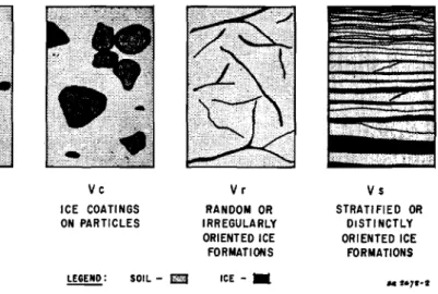
FIG B. VISIBLE ICE LESS THAN ONE INCH THICK 0 I 2 U)
...
セ 3 :!:....
4 UI 5 6 Vx INDIVIDUAL ICE INCLUSIONS Vc ICE COATINGS ON PARTICLES セZ SOIL-D
Vr
RANDOM OR IRREGULARLY ORIENTED ICE FORMATIONS ICE - . Vs STRATIFIED OR DISTINCTLY ORIENTED ICE FORMATIONS M 1.71-1...
Q)TABLE I (cont'd) ICE DESCRIPTIONS
C. VISIBLE ICE-GREATER mAN 1 INCH
rarer
Subgroup
Group Field Identification
Symbol Description Symbol
Ice with soil ICE
+
Designate material as ICECo)and use descriptiveinclusions soil type terms as follows, usually one item from each
ICE group, when applicable:
Ice without ICE Hardness Structure(b)
soil inclusions HARD CLEAR
SOFT CLOUDY
(of mass, not POROUS
individual CANDLED crystals) GRANULAR STRATIFIED Colour Admixtures (Examples): (Examples): COLOURLESS CONTAINS
GRAY FEW mIN
BLUE SILT INCLUSIONS
(0)Where special forms of ice such as hoarfrost can be distinsuished, more explicit
descrip-tion should be Siven.
(b)Observer should be careful to avoid beins misled by surface scratches or frost coatins
,
I:.•
セ セ 2 %: l -%: ..J U セイョ セ .... z kJ8
2•
z kJ ェAZセ 0 セ - - ' z : . uz < 1&.1-...
%: セ セ I-0:: kJ I-«ImI
kJ L; Ill: I C) .... kJ 0 U'"
-' YJ ....J Orn ...J 0 rnzセi
CD tI) ZコZセ U>ca
.... rn- : > セ > kJ :'...JU U 2 1&.1u -Z C) セ 0 N,..,
...
....
'"
sShセni 17TABLE
n
TERMINOLOGY
Ice CoatinA8on Particles are discernible layers of ice found on or below the larger soil particles
in a frozen 8011 mass. They are sometimes associated with hoarfrost crystals, which have qrown into voids produoed by the freezing action.
Ice Crystalis a very small individual ice particle visible in the face of a soil mass. Crystals may be
present alone or in combination with other ice formations.
lii
Clear Iceis transparent and contains only a moderate number of air bubbles.Cloudy Iceis relatively opaque due to entrained air bubbles or other reasons, but which is essentially
sound and non-pervious.
Porous Ice contains numerous voids, usually interconnected and usually resulting from melting at
air bubbles or along crystal interfaces from presence of salt or other materials in the water, or from the freezing of saturated snow. Though porous, the mass retains its structural unity.
Candled Iceis ice that has rotted or otherwise formed into long columnar crystals, very loosely bonded
Granular Ice is composed of couse, more or less equidimensional, ice crystals weakly bonded together.
Ice Lenses.are lenticular ice formations in soil occurring essentially parallel to each other, generally
normal to the direction of heat loss and commonly in repeated layers.
Ice Segregation is the growth of ice as distinctlenses, layers, veins, and masses in soils commonly
but not always, oriented normal to direction of heat loss.
Well-bondedsignifies that the soil particles are strongly held together by the ice and that the frozen
soU poBBesses relatively high resistance to chipping or breaking.
:D
Poorly-bondedsignifies that the soil particles are weakly held together by the ice and that thefrozen soil consequently has poor resistance to chipping or breaking.
Friabledenotes extremely weak bond between soil particles. Material is easily broken up.
E:llcess Icesignifies ice in e:llCeBB of the fraction that would be retained as water in the soil voids upon
thawing.
For a more complete list of terms generally accepted and used in current literature on Frost and Permafrost see Hennion, F. "FROST AND PERMAFROST DEFINITIONS", Highway Research Board,
APPENDIX A
SAMPLE FORMS FOR PERMAFROST nELD RECORDS
I. EXPLORATION&: TERRAIN NOTES 1. LOCATION: Thunder River, N.W.T.
SITE: Centre Proposed Hostel-Site 4 AIR PHOTO: A 18635-49; N 1.7, W 4.3
セ NA &:NR.Plan-TR·A·l
NOTESBY: John Smith
HOLE No. T.P. 24 DEPTH: 22'
ELEVATION: 28' above river water level (hand level)
DATE: START a.m, 14/8/56
END p.m. 17/8/56
2. METHOD OF EXPLORATION: Portable gasoline powered jackhammer.
Pit Size----4' ][ 6'-3 local labourers.
REMARKS: No difficulties, log cribbing from 14'-22'. Rainallday 15/8/56
3. VEGETATION COVER SYMBOL-SITE
m
AREA IFDESCRIPTION: At Site-irregular distribution of grass hummocks and sedges with moss covering most of surface--odd low shrub. Area-predominantly moss covered with irregular distributionof
grasses and sedges. 4. RELIEF
REGION: Lowland, flat, recent alluvium.
セ SITE: 6' high grass tussocks, some mounds 4' in diameter and l' high.
5. DRAINAGE: Poor--many puddles of scum covered water. During spring run off overflow probably runs to small creek200'E. (which is now dry) and thence to river.
6. GENERAL
DEPTH OF mAW-HOLE-AVERAGE 20' Maz. 26' Min. 10' DATE 16/8/56
AREA·AVERAGE 18' Mu. 2'1' Min. 10' DATE 16/8/56
II. PERMAFROST - SUBSURFACE FEATUBES
Dth Hole Depth, Boil Depth, Ice Boil
ft. Log ft. Deecriptlon ft. Description Be=pl. . Photo Re=arb
-Cat. #8-light to Photo. taken
Pt dark brown THAWED on northwall
-
1.2 of pitセ
1.6
---
,
2-Fro_n--no vlaibl. lea
- Pt .eg.,wen
bonded-Nbn Peat-.=etegory # 13-- =ateriel breake In 1
.leb. 12" long" 3"
reddiah brown to thick
4 - dark brown-._--- 1 branch et 3.S ft.-4.6 4in. indiazneter
---.
. -Pt Hairline ice18ns••• V.ln about1· spacing in 1 6 - Nbn Nbn - - - - 6.8 6.8 - H.L. hor. len. .eセBBM Light brown ellty toセB・セ。cゥョァN Yielble 2-M/C 1
6 - V. fine sand ice =16 0of total I-G.B.
I
volulne
- - - - 8.5 6.5
-
I
1· hor. ice len. . .CH
I
• paced about 8 In.- I-G.B. 110 - V.
i
odd diaJonellen.(2. In. long)x.i,ice 2-M/C---_. Grey cley. high 10.8
---
-.---
-I pl_ticity. random
10.GOating aton_ up toセN thlak,。セセ I1-0.8. I I thiakn- about7iw CH Nbn
14-- I
14.3 -18 - ICE -.----...-_. 18-_ -_I
19.0 1IO -II
Ora. .l, poorlr, OP graded, mo.ty Vc ....unded .to.... H·--, 2· In diamatar llll-I---1aa.o
Noセ「ャ。 lca . .gra-lJatlon, wan bondad
14.3
loa with clay lnc.-loa_ft, cloudy, milky whita: clay
lnal._ngular.••ge.
I· lonlJ,セN thick 17.7 1'--·_··__·_·---· loa_ft, cloudy, milkywhita 19.0 3-Mtc 1-0.8. I BOTTOM OF EXPLORATION