Publisher’s version / Version de l'éditeur:
Proceedings of the 18th International Symposium on Methodologies for Intelligent
Systems (ISMIS 2009), 2009-09-17
READ THESE TERMS AND CONDITIONS CAREFULLY BEFORE USING THIS WEBSITE. https://nrc-publications.canada.ca/eng/copyright
Vous avez des questions? Nous pouvons vous aider. Pour communiquer directement avec un auteur, consultez la Questions? Contact the NRC Publications Archive team at
[email protected]. If you wish to email the authors directly, please see the first page of the publication for their contact information.
NRC Publications Archive
Archives des publications du CNRC
This publication could be one of several versions: author’s original, accepted manuscript or the publisher’s version. / La version de cette publication peut être l’une des suivantes : la version prépublication de l’auteur, la version acceptée du manuscrit ou la version de l’éditeur.
Access and use of this website and the material on it are subject to the Terms and Conditions set forth at
GIS-FLResolution: A Spatial Analysis Platform for Static and
Transportation Facility Location Allocation
Gu, Wei; Wang, Xin; Geng, Liqiang
https://publications-cnrc.canada.ca/fra/droits
L’accès à ce site Web et l’utilisation de son contenu sont assujettis aux conditions présentées dans le site LISEZ CES CONDITIONS ATTENTIVEMENT AVANT D’UTILISER CE SITE WEB.
NRC Publications Record / Notice d'Archives des publications de CNRC:
https://nrc-publications.canada.ca/eng/view/object/?id=37ffb423-a10c-44e2-ade1-730c3c4d99e5 https://publications-cnrc.canada.ca/fra/voir/objet/?id=37ffb423-a10c-44e2-ade1-730c3c4d99e5
GIS-FLResolution: A Spatial Analysis Platform for Static
and Transportation Facility Location Allocation
Wei Gu1 , Xin Wang1 , and Liqiang Geng2
1
Department of Geomatics Engineering, University of Calgary, Calgary, AB (Canada)
2
NRC Institute for Information Technology, Fredericton, NB (Canada) {wgu, xcwang}@ucalgary.ca, [email protected]
Abstract. Static and transportation facility location allocation problem is a new problem in facility location research. It tries to find out optimal locations of static and transportation facilities to serve an objective area with minimum costs. The problem is challenging because two types of facilities are involved and cooperate with each other. This paper proposes a new stand-alone GIS platform, GIS-FLResolution, to solve the problem. Combined with a customized algorithm called STFLS, the platform built on MapObjects can successfully give results with a friendly user interface. Preliminary experiments have been conducted to demonstrate the efficiency and practicality of the platform.
Keywords: Facility location problem, Static facility, Transportation facility,
Geographical Information Systems (GIS)
1
Introduction
Facility location problem is an important research topic in spatial analysis which solves problems of matching the supply and demand by using sets of objectives and constraints [1]. The objective is to determine a set of locations for the supply so as to minimize the total supply and assignment cost. For instance, city planners may have a question about how to allocate facilities such as hospitals and fire stations for new residence area. The decision will be made based on the local populations and the capability of the limited resources. For another example, a local school board may provide accessible service to a population while minimizing the total distance travelled by the students. These examples are involved with single type of facilities such as hospitals, fire stations or schools. Various methods for the single type of facility location problem have been proposed for the above applications [1, 2, 3, 4, 5].
In reality, we often face two types of facilities location problem when the number of the single type of facilities within a service area is inefficient. For example, for emergency medical services, we can locate the hospital locations in such a way that it achieves full coverage of a service with the minimum total travelling distance. This usually ends up the hospital locations close to the dense community. However, for the residents in the sparse and remote area, since the number of hospitals is limited, in order to offer fast response time, the ambulance should be located to shorten the time to access medical services. In this application, two types of facilities need to be
located in a region, static facilities (e.g. hospitals) and transportation facilities (e.g. ambulances). The service is supplied to the customers by the cooperation of these two types of facilities. In addition, dependency relations usually exist between different types of facilities. Specifically, the locations of transportation facilities are dependent on the locations of static facilities and demand objects. For example, the locations of ambulances will be determined by both residence locations and hospital locations. However, none of the current algorithms can apply to the two types of facilities location problem directly.
During the past 30 years, Geographical Information Systems (GIS) has evolved into a mature research and application area involving a number of academic including Geography, Civil Engineering, Computer Science, Land Use Planning and Environmental Science [6]. By supporting a wide range of spatial queries and analyses, GIS is playing a significant role in location model development and application. Many GIS software have been developed in use in municipalities, states, utilities, and governmental agencies, which range from simple, limited systems to large, complex software systems. However, none of them include the analyzing function which can be used to the two types of facilities location problem directly.
In this paper, we propose a novel heuristic algorithm to solve the two types of facilities location problem. Instead of only minimizing the average travelling distance between the static facilities and demand objects, the new algorithm also considers the constraint between the transportation facilities and static facilities. Based on the new algorithm, we also present a simple GIS platform, GIS-FLResolution, that was designed to help geographers and civil researchers facilitate their research.
The rest of the paper is organized as follows. Section 2 summarizes related work on the location allocation problem and GIS. In section 3, the GIS-FLResolution platform is presented. We first give a formal definition of the static and transportation facility location problem. Then, the structure and workflow of the platform are introduced. Finally, the details of the algorithm called STFLS used in the platform are discussed. Experimental studies on synthetic and real datasets are presented in Section 4. Finally, Section 5 concludes the paper with future research directions.
2
Related Work
Facility location decisions are critical element in strategic planning for a wide range of private and public firms [7]. Three common objectives on the single level facility location problem have been studied:
The P-Median Problem—seeking to locate a given number of facilities that minimizes the total distance travelled from all demand points to their nearest serving facilities. When applied to a general network, the P-median problem is hard to be solved optimally (this type of problems is NP-hard). However, by limiting potential facility locations on the network nodes, the P-median problem can be solved in polynomial time. Several integer programming techniques and efficient heuristics have been developed for solving this problem [8]. Recently, Zhang et al.[9] propose the min-dist optimal-location query in spatial database to find the optimal location for one single facility. They prove a theorem that the number of candidate locations is
finite and a min-dist optimal location exists at some intersection points of horizontal and vertical lines passing through demand objects. The theorem limits the number of candidate locations without losing the power to find the exact answers. However, this method can only allocate one facility using the Manhattan distance.
The Center Problem—locating a given number of facilities that minimizes the maximum distance while asking for coverage of all demand points. If facility locations are restricted to the nodes of the network, the problem is a vertex center
problem. Center problems which allow facilities to be located anywhere on the
network are absolute center problems [8].
The Covering Problem— finding the locations of a fixed number of facilities that maximizes the total demand covered by them within a maximum acceptable distance. In [7], Pacheco et al. proposes a method to solve the problem under probabilistic condition. They adapted three metaheuristic strategies—scatter search, tabu search, and variable neighborhood search—to find the best locations in Spain’s Burgos province to place health resources for treating people in diabetic comas. Similar to the
P-median problem above, the covering problem is NP-complete for general networks.
Covering problem model is widely used to determining the deployment of Emergency Medical Service System (EMS) vehicles in environments [10, 11].
While the earlier approaches consider that each static facility candidate can satisfy an unlimited number of demand points, recent approaches tend to give each candidate facility has limited capacity, i.e. a maximum number of demand points that it can satisfy. To identify the assignment with the optimal overall quality, Ghoseiri and Ghannadpour [12] propose an urgencies capability constraint facility allocation method that gives an assignment between a static facility and a demand point through urgencies. An urgency is a method to define a precedence relationship between points, which can also be viewed as a priority.
GIS is an ideal and sometimes indispensable tool for analyzing location allocation problem. The central element of a GIS is the use of a location referencing system so that data about a specific location can be analyzed in its relationship to other locations. Church [6] provides a review of GIS and location modeling and points out there is an inextricable link between GIS and Location Science. Gerrard et al. [13] present an application using the ARC/INFO [14] location model capabilities applied to biological reserve site selection. Ruggles and Church [15] have used a GIS to generate and maintain many possible scenarios for an application of a location model to historical settlements in the Basin of Mexico.
3
GIS-FLResolution
In this section, we present a new GIS platform called GIS-FLResolution to solve static and transportation facility location problem. In Section 3.1, we give the formal definitions of the problem. Section 3.2 describes the implementation and workflow of GIS-FLResolution. In Section 3.3, the searching algorithm used in the platform is discussed.
3.1 Static and Transportation Facility Location Problem
Static and Transportation Facility Location (STFL) problem is about how to allocate capacitated static and transportation facilities in a given region, which aims to minimize the average travelling distance from demand objects to static facilities and the maximal travelling distance by transportation facilities.
Definition 1 Given a set of demand objects D and a set of static facilities S, the
average travelling distance (ATD) is defined as: ATD = ( , ) * . . djD djD j i j j dist d s d w d w
, where si , S dj and D
s
i is dj’s assigned staticfacility. d w is a positive number representing the demand of the demand object j. d . j Definition 2 Given a set of demand objects D, a set of static facilities S and a set of transportation facilities T, the transportation travelling distance (TTD) of the demand object
d
j is defined as:( j) ( j, i|| k) ( j, i)
TTD d dist d s t dist d s , where siS
,
djD , tk T and( j, i|| k)
dist d s t is the distance from a location of a demand objectdj to its assigned
static facility location
s
i or the closest transportation facility locationt
k , whichever is shorter.3.2 Design and Implementation
Fig. 1 Workflow of GIS-FLResolution Fig. 2 User interface of GIS-FLResolution
GIS-FLResolution is developed by using Java and MapObjects-Java standard edition [16]. MapObjects is an easy-to-use, pure Java application programming interface (API) that enables programmers to develop custom Java clients or
implement stand-alone GIS mapping solutions. Through calling a suite of Java mapping and non-visual components in MapObjects, GIS-FLResolution has an ability of reading diverse data sources and mapping properties in an appreciate scale. By combined with a customized facility location allocation algorithm, GIS-FLResolution can successfully solve the STFL problem. Fig. 1 shows the workflow of the platform. As shown in Fig. 2, after starting the platform, a friendly user interface is displayed. By selecting File
Add Layer, a user uploads a database to the platform. Then theplatform calls the customized algorithm to find the most suitable locations of static facilities and transportation facilities. Finally, the results are mapped to the user interface. In the following subsection, the customized algorithm will be introduced in detail.
3.3 STFLS: A Heuristic Method for STFL Problem
Static and transportation optimal facility locations problem is a NP-hard problem. In this subsection, we propose a new heuristic method called Static Transportation Facilities Location Searching Algorithm (STFLS). The algorithm contains of two steps (shown in Fig. 3): static facility location searching and transportation facility location searching.
STFLS(D, S, T)
Input: a set of demand objects D, a set of static
facilities S with unknown locations, and a set of transportation facilities T with unknown locations
Output: locations of S and T
/* static facilities locations searching step */ 1 SearchStaticFacilityLocations (D,S)
/* transportation facilities locations searching step*/ 2 SearchTransportationFacilitiesLocations(D,S,T, threshold)
Fig. 3. Pseudo code of STFLS
3.3.1 Static Facility Location Searching
In this step, we propose a heuristic method to find local optimal locations using clustering. Clustering is the process of grouping a set of objects into classes so that objects within a cluster have high similarity to one another, but are dissimilar to objects in other clusters [17]. The clustering process is used to reduce the searching area.
Fig. 4 presents the pseudo-code of static facility location searching. The procedure involves three steps:
Step 1: initialization. First, the locations of static facilities are picked randomly in line 1. Secondly, every demand object is assigned a static facility by using urgency capability constraint assignment method [12] in line 2. After the assignment, each static facility together with its assigned demand objects is considered as a cluster.
Step 2: intra-cluster searching. The goal of the step is to find the local optimal location to minimize the average travelling distance from demand points to the static facility in each cluster. Because the objects in a cluster are closer to each other than the objects from other clusters, for every static facility in a cluster, we assume that its optimal location should be in that cluster. Through separating the whole area into different clusters, the searching space for every static facility is reduced from the whole area to its cluster. First, findIntraCluOptimalLoc finds the local optimal location for each static facility from its cluster. The local optimal location is saved in
newIntraPos and its corresponding minimum average travelling distance is saved in newAverageDist in lines 6-7. Secondly, insert newIntraPos into tempPosList
which stores the local optimal location in each cluster and insert newAverageDist
into tempDistList which stores the minimum average travelling distance in lines 8-9.
Step 3: inter-cluster searching. The goal of the step is to compare the local optimal
static facilities’ location in every cluster and select one which can reduce the average distance most as shown in lines 10-11. Because each cluster is defined as the locations of a static facility and its assigned demand objects, after changing the static facility’s location, the clusters need to be rebuilt by assigning all demand points to new static facilities in line 12. The reason we only change one static facility to its new local optimal location is that all the local optimal locations for static facilities are determined under the same distribution of static facilities in step 2. Thus, once one static facility’s location is changed, the other static facilities’ local optimal locations could be changed.
Step 2 and step 3 are iterated until no change happened in step 3.
SearchStaticFacilityLocations (D,S)
Input: a set of demand points D, a set of static
facilities S with unknown locations.
Output: locations of S.
Initialize: hasBetterStaticLocation=True, miniDist=0
averageTralDist=0
1 randomly choose the initial locations for static facilities in S
2 UrgencyCapabilityConstraintAssignment (D,S)
/*calculate the average travelling distance for current arrangement of static facilities.*/
3 averageTralDist = calculateAverageTralDist(D,S) 4 while(hasBetterStaticLocation) //static facilities exchanging
/* Intra-cluster searching */ 5 { for all s
S do6 { newIntraPos=findIntraCluOptimalLoc(s,D,S) 7 newAverageDist=calAveDist(newIntraPos,D,S) 8 insert (newIntraPos, tempPosList)
9 insert (newAverageDist, tempDistList) } /* Inter-cluster searching. Find the smallest value in tempDistList and its corresponding position in
tempPosList. Then record this distance as minDist, the position as newPos, the original location of static facility in the cluster as oldPos. */
10 newPos, oldPos, minDist
findInterclusterOptimalLoc(tempDistList, tempPosList) 11 exchange(newPos, oldPos)
/*reassign the demand points to static facilities.*/ 12 urgencyCapabilityConstraintAssignment(D,S) 13 if(minDist < averageTralDist)
14 averageTralDist = minDist
15 else /* this step terminates if the last local altering did not result in a change */
16 hasBetterStaticLocation = False }
Fig. 4. Pseudo code of static facility location searching
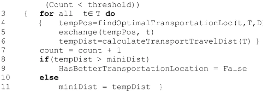
3.3.2 Transportation Facilities Location Searching
Locations of transportation facilities depend on both locations of demand objects and static facilities. To reduce the computation time, we use a greedy method in this step. The method includes 3 steps. Fig. 5 presents the pseudo-code of transportation facilities location searching.
Step 1: initialization. Randomly choose the initial locations for all transportation facilities in line 1.
Step 2: exchanging. The strategy is that it changes every transportation facility to the location whichever reduces the maximum transportation travelling distance most within each iteration. First, findOptimalTransportationLoc finds the optimal location for each transportation facility. The optimal location is stored in tempPos as shown in line 4. Then each transportation facility is changed to a location which reduces the maximum transportation travelling distance most in line 5 and the corresponding minimum transportation travelling distance is saved in tempDist in line 6.
Step 3: calculation. Calculate the transportation facility travelling distance of every demand point and determine every transportation facility’s service list of demand points under current transportation facility locations in line 6.
Step 2 and step 3 are iterated until no change is made in step 2 or the iteration times reach the predefined threshold.
SearchTransportationFacilitiesLocations(D,S,T,threshold) Input: a set of transportation facilities T, a set of
demand points D, threshold is a positive number the user input which presents the maximum iteration times.
Output: locations of T
Initialize: hasBetterTransportationLocation = True,
miniDist = ∞, count = 0;
1 randomly choose the initial locations for transportation facilities in T.
(Count < threshold)) 3 { for all t
T do 4 { tempPos=findOptimalTransportationLoc(t,T,D) 5 exchange(tempPos, t) 6 tempDist=calculateTransportTravelDist(T) } 7 count = count + 1 8 if(tempDist > miniDist) 9 HasBetterTransportationLocation = False 10 else 11 miniDist = tempDist }Fig. 5. Pseudo code of transportation facility location searching
4
Experiments
4.1 Comparison between GIS-FLResolution and Optimal solution
Synthetic datasets for demand objects were created in a 300
300area. The values in the following experiments are the average of the results which are from running the algorithm six times. To compare the performance of GIS-FLResolution with the optimal solution, we generate a dataset with 100 demand objects and locate 3 static facilities and 2 transportation facilities. The weight of each demand object is 30 and the capability of each static facility is 1000. Table 1 shows that the optimal solution has a better performance than GIS-FLResolution but it is time consuming.Table 1. The comparison between STFLS and the optimal solution
GIS-FLResolution
Optimal solutionAverage traveling distance 48.7 46.5 Maximum traveling distance 199.0 192.3
Execution time (s) 1 200
4.2 Experiment with Real Data
This section presents a sufficient-capacity experiment with a real data set from South Carolina, which is to locate five hospitals and three ambulances. The data set consists of 867 census tracts (Census2000), with each treated as a demand object. The population of each census tract is considered as the demand weight of each object, which varies from 197 to 16,745. The total population (or demand) is 4,212,012. Centroid of each census tract is used as the locations of the corresponding demand objects. Capabilities of the hospitals range from 800,000 to 1,400,000.
Fig. 5 presents the result of using GIS-FLResolution. denotes for the location
of a hospital. represents the location of ambulance. The points marked by , and stand for different ambulance’s service area. In Fig. 5, two ambulances being close with each other does not indicate that the result is not accurate. One ambulance serves the demand objects marked by and another one serves the demand objects marked by . Since the function of ambulances is to minimize the maximum transportation travelling distance, the ambulances are not assigned to the centroids of their service area. The average travelling distance is 56.2 km, the maximum transportation travelling distance is 260 km and the execution time is 12 seconds.
Fig. 5. Solution to a real dataset using GIS-FLResolution
5
Conclusion and Future Work
In this paper, we introduce a new type of facility location problem with both static and transportation facilities and propose a novel heuristic algorithm STFLS to solve it. STFLS assigns two types of facilities to the local optimal locations based on the spatial distribution of demand objects and the dependency of the facilities. Based on STFLS, a stand-alone GIS platform, GIS-FLResolution, is presented. The platform gives a friendly user interface. To our knowledge, GIS-FLResolution is the first platform to handle the location allocation problem about two types of facilities. According to the experimental results, GIS-FLResolution can accurately allocate two types of facilities into an area.
In the future, we will extend the problem to multiple types of facilities and extend the platform with flexible interface which can be used in a wide range of applications.
In addition, we seek to introduce a pre-processing method and spatial data index in our algorithm to reduce the execution time. Finally, with the publishment of ArcEngine (a new version of GIS components and developer resources) which supports dynamic mapping and information releasing in web environments, we plan to update from MapObjects to ArcEngine.
References
1. Owen, S.H., Daskin, M.S.: Strategic facility location: A review. European Journal of Operational Research, vol. 111, issue. 3, pp. 423-447 (1998)
2. Longley, P., Batty, M.: Advanced Spatial Analysis: The CASA Book of GIS. ESRI, (2003)
3. Arya, V., Garg, N., Khandekar, R., Pandit, V., Meyerson, A., Mungala, K.: Local search heuristics for k-median and facility location problems. In Proceedings of the 33rd Annual ACM Symposium on the Theory of Computing, pp. 21–29 (2001)
4. Jain, K., Mahdian, M., Saberi, A.: A new greedy approach for facility location Problems. In Proceedings of STOC (2002)
5. Charikar, M., Khuller, S., Mount, D.M., Narasimhan, G.: Algorithms for facility location problems with outliers. In Proceedings of SODA (2001)
6. Church, R.L.: Geographical information systems and location science. Computers and Operations Research, vol. 29, issue. 6, pp. 541–562 (2002)
7. Pacheco, J., Casado, S., Alegre, J.F.: Heuristic Solutions for Locating Health Resources. IEEE Intelligent Systems, vol. 23, issue. 1, pp. 57-63 (2008)
8. Daskin, M.S.: Network and Discrete Location: Models Algorithms and Applications. Wiley (1995)
9. Zhang, D., Du, Y., Xia, T., Tao,Y.: Progressive Computation of The Min-Dist Optimal-Location Query. In Proceedings of International Conference on Very Large Data Bases(VLDB), pp. 643-654 (2006)
10. Daskin, M.S.: Application of an Expected Covering Model to Emergency Medical Service System Design. Decision Sciences, vol. 13, issue. 3, pp. 416-439 (1982) 11. Jia, H., Ordonez, F., Dessouky, M.: A modeling framework for facility location of
medical service for large-scale emergencies. IIE Transactions, vol. 39, issue. 1, pp. 41-55 (2007)
12. Ghoseiri, K., Ghannadpour, S.F.: Solving Capacitated P-Median Problem using Genetic Algorithm. In Proceedings of International Conference on Industrial Engineering and Engineering Management(IEEM), pp. 885-889 (2007)
13. Gerrard, R.A., Stoms, D.A., Church, R.L., Davis, F.W.: Using GIS models for reserve site selection. Transactions in GIS, vol. 1, issue. 2, pp. 45-60 (1996)
14. ArcInfo website, http://www.esri.com/software/arcgis/arcinfo/index.html
15. Ruggles, A., Church, R.L.: An analysis of late-horizon settlement patterns in the Teotihuacan-Temascalapa basins, a location-allocation and GIS approach. In: Aldenderfer MS, Maschner HDG. editors. Anthropology, space and geographic information systems. Oxford: Oxford University Press (1997)
16. MapObjects-Java standard edition, http://www.esriuk.com/products/product.asp?prodid=46&
17. Han, J., Kamber, M., Tung, A.K.H.: Spatial Clustering Methods in Data Mining: A Survey. H. Miller and J. Han(eds.), Geographic Data Mining and Knowledge Discovery, Taylor and Francis (2001)
![Fig. 1 Workflow of GIS-FLResolution Fig. 2 User interface of GIS-FLResolution GIS-FLResolution is developed by using Java and MapObjects-Java standard edition [16]](https://thumb-eu.123doks.com/thumbv2/123doknet/14154136.472229/5.918.220.699.636.886/workflow-flresolution-interface-flresolution-flresolution-developed-mapobjects-standard.webp)