Civilian Applications and Policy Implications of Commercial Unmanned Aerial Vehicles
by
Kara Lynn Sprague
Master of Engineering in Electrical Engineering and Computer Science Massachusetts Institute of Technology, 2002
Bachelor of Science in Electrical Engineering and Computer Science Massachusetts Institute of Technology, 2001
Submitted to the Engineering Systems Division in Partial Fulfillment of the Requirements for the Degree of
Master of Science in Technology and Policy at the
Massachusetts Institute of Technology June 2004
2004 Massachusetts Institute of Technology All rights reserved.
Signature of Author………... Technology and Policy Program, Engineering Systems Division May 7, 2004
Certified by………... Eric Feron Associate Professor of Aeronautics and Astronautics Thesis Supervisor
Accepted by....………... Dava J. Newman Associate Professor of Aeronautics and Astronautics and Engineering Systems Director, Technology and Policy Program
Civilian Applications and Policy Implications of Commercial Unmanned Aerial Vehicles
by
Kara Lynn Sprague
Submitted to the Engineering Systems Division on May 7, 2004 in Partial Fulfillment of the Requirements for
the Degree of Master of Science in Technology and Policy
Abstract
As UAV capabilities continue to improve the technology will spill out of the military sector and into commercial and civil applications. Already, UAVs have demonstrated commercial marketability in such diverse areas as scientific and environmental research, cross-seas shipping, communications relays, emergency management, border monitoring, agriculture, and aerial photography. Small-scale tactical UAVs in particular have an enormous potential to fulfill a number of roles within urban centers, transforming the way civil safety institutions carry out their jobs. A lack of established flight regulations is currently the greatest barrier to the standardized use of these vehicles. While the United States is currently the world’s leader in UAV manufacturing, this position is tenuous given strong competitive threats from a variety of foreign countries who are already ahead in establishing a standardized regulatory environment for UAVs.
As part of a larger research effort focused on the design, implementation, and demonstration of highly maneuverable rotorcraft UAVs, the primary objective of this work is to examine how UAVs might gain access to and function safely in civil and commercial markets. Despite the wide variety of existing UAVs in terms of size, targeted flight altitude, and capability, this work focuses primarily on small-scale tactical vehicles with the intended purpose of operating in and around urban centers. Operational requirements and risk mitigation strategies can be devised and effectively implemented to allow such UAVs to be operated at an acceptable level of risk. By combining GIS data manipulation with modern approaches to path-planning, UAVs can be operated such that the risk to the general public and urban infrastructure is minimized.
Instead of focusing on vehicle reliability requirements which severely limit present-day experimentation and development of UAVs, efforts which focus on operational strategies allow for applications of the technology to be explored while the systems continue to grow more reliable. Public-private coalitions should expand their efforts beyond high altitude, long endurance UAVs to establish operating regulations for all of the vehicle classifications. The diversity of UAVs should be treated with an equally diverse set of regulations tuned to the particular requirements and risk management issues each classification represents. Finally, local and national government should recognize civil UAVs not only as a new commercial industry of great potential, but also as a latent threat to domestic security for which regulations should be established sooner rather than later.
Thesis Supervisor: Eric Feron
Acknowledgements
I would like to thank Professor Eric Feron, Tom Schouwenaars, Rodin Lyasoff, Mario Valenti, and Phil Root. The MIT Helicopter Team continues to be a tremendous source of thought, innovation, and technical know-how. Roland Weibel has also been a remarkable help in providing preliminary risk formulations for UAVs. Special thanks to Daniel Sheehan for bestowing me with his knowledge of geospatial information systems. I would also like to thank Cambridge Mayor Michael Sullivan, MIT Chief of Police John Di Fava, and Cambridge Fire Chief Gerald Reardon for taking the time out of their busy schedules to provide me with invaluable information about civil safety organizations.
Contents
1 Introduction...7 1.1 Motivation ... 8 1.2 Commercial Barriers ... 10 1.2.1 Regulations ... 10 1.2.2 Affordability ... 12 1.2.3 Requirements ... 13 1.2.4 Liability ... 13 1.2.5 Capability... 13 1.2.6 Communications... 14 1.2.7 Public Perception... 14 1.2.8 Interactions ... 141.3 Objectives and Outline ... 16
2 Case Study: The MIT Helicopter...18
2.1 History of the MIT Helicopter Project ... 18
2.2 Flight System... 19
2.3 Capabilities... 20
2.4 Current Limitations ... 21
3 Integrated Needs Assessment...23
3.1 Interviews ... 23
3.1.1 Massachusetts Institute of Technology Campus Police Department (The Police at MIT, 2002)23 3.1.2 Cambridge Fire Department (Reardon, 2003) ... 25
3.2 Use Scenarios ... 26
3.2.1 Surveillance and Video Reconnaissance ... 27
3.2.2 Hazardous Situations ... 27
3.2.3 Patrols ... 28
4 Risk Mitigation...29
4.1.1 Ground Impacts ... 30
4.1.2 Midair Collisions ... 33
4.1.3 General Shortcomings ... 35
4.2 Path Planning... 35
4.2.1 Approaches to Path Planning... 35
4.2.2 Global Information Systems ... 37
4.2.3 Application to UAVs ... 40
5 Policy Recommendations...42
5.1 Concerns... 42
5.2 Implications... 44
5.3 Future Work ... 45
List of Figures
Figure 1.1: System Diagram ... 15
Figure 2.1: The MIT flight vehicle equipped with avionics box ... 19
Figure 3.1: MIT Police 2002 Most Frequently Requested Activities ... 24
Figure 4.1: Ground exposure risk formulation applied to a UAV weighing 351 lb. ... 31
Figure 4.2: Ground exposure risk formulation applied to a UAV weighing 9.6 lb. ... 32
Figure 4.3: Ground exposure risk formulation applied to a UAV weighing 2.12 oz... 32
Figure 4.4: Midair collision risk results ... 34
Figure 4.5: Sample GIS raster data, MIT campus... 39
Figure 4.6: Sample GIS vector data, MIT campus... 39
Figure 4.7: Sample risk-minimized path, MIT campus ... 40
Chapter 1
Introduction
Years before the Wright brothers achieved the first manned airplane flight, primitive UAV technology was used in at least two wars for combat and surveillance. The first known UAV was an unmanned aerial bomber, invented by Charles Perley in 1863 for use in the Civil War. Perley designed a hot air ballon filled with explosives. The hinged basket was equipped with a timer which would simultaneously release the explosives and ignite a fuse. Only two decades later, Douglas Archibald conceived the idea of using large kites for aerial photography. Archibald’s concept was soon recognized for its potential military applications by Corporal William Eddy of Colorado. The first wartime surveillance photos in history were taken during the Spanish-American War of 1898 using a kite rigged like Archibald’s featuring a long shutter release attached to its string. As UAV technology continued to develop throughout the 20th
century, it obtained a permanent and critical role in high-tech military arsenals. Deployment of vehicles such as the Darkstar, Predator, and Global Hawk for surveillance and reconnaissance missions is now standard procedure. The U.S. military is currently operating a fleet of over 510 UAVs consisting of ten different flight platforms. Of those 510 vehicles, up to 130 are actively engaged in flight operations at any one time.
The role of UAVs has only recently been expanded to include the monitoring of the Earth’s environment from high altitudes. For example, Pathfinder is a solar-powered, ultra-lightweight research aircraft developed by AeroVironment Corporation being tested for environmental research. In 1997, Pathfinder reached an altitude of 67,350 feet, the highest altitude ever reached by a solar aircraft. The vehicle collects wind and weather data with extremely fine sensors and snaps digital images at high resolution. As the technology continues to improve, UAV applications will depart more from their traditional military functions, perhaps even filling new product niches in the commercial sector. The Helios, now under development, will incorporate a fuel cell energy storage system to provide power for flying through the night, making it capable of continuous flight at 50,000 - 70,000 feet for months at a time. Within 10
years, Helios aircraft are expected to be widely deployed as broadband communications platforms, providing a uniquely cost-effective complement to satellite and terrestrial communication systems. Long endurance UAVs, such as Helios, have the potential to fill the gap between satellites and surface networks in an integrated observing system. This gap is presently limited by pilot endurance in traditional aircraft and the lack of technically feasible low-cost alternatives. Other advanced platforms are designed for use in military surveillance, law enforcement, and civilian rescue efforts (Nova, 2002). In total, the market for both military and commercial UAVs is expected to top $10 billion over the next decade (e-Drive Executive Report, 2004).
1.1 Motivation
Since the mid 1900’s, the use of automation in mission-critical and life-sustaining systems has become prolific. The complexity of these systems continues to grow as advances in both hardware and software technologies make possible new implementations and applications. Unfortunately, what can be modeled as a linear growth in system complexity requires exponential growth in safety assurance and verification analysis to provide a commensurate level of flight system certification (Abdul-Baki, 2000). Given the highly volatile market for software and hardware engineering and the speed at which technologies change, it is becoming increasingly difficult for safety-critical systems to both maintain safety standards and exploit opportunities to streamline and re-engineer systems to improve performance and reduce cost (Gavrilets - Aggressive Maneuvering, 2001).
The most stunning example of the growing divide between the technology that is usable because it has undergone extensive verification and certification and the commercial technology that is unusable due to a lack of certification is in the avionics industry. The Federal Aviation Administration faces tremendous difficulties integrating new technologies with regulations and flight platforms due to the safety-sensitive nature of the aviation industry. The field of UAVs offers a good test bed for analyzing how an emerging technology can be best incorporated into existing regulatory frameworks. These aircraft also offer the opportunity to streamline and develop verification and certification processes for new technologies without directly endangering human life and at a much lower cost than their full-sized counterparts. Thus there is much more room for experimentation in the way of systems and control engineering as well as policy analysis and development.
Although radio-controlled planes and helicopters have been flown by hobbyists and enthusiasts for many years with only few regulatory requirements, UAVs introduce new elements of uncertainty and risk that must be addressed. UAVs are capable of operating without an internal pilot, are tethered by a radio
control link, and can be preprogrammed for both flight and payload operations prior to launch. While the former two characteristics are shared by standard radio-controlled aircraft, the latter quality is unique to UAVs and is one of the primary motivations for stringent regulations on the use of unmanned aircraft in civilian airspace. UAVs are currently considered unsuitable for domestic urban environments due to safety concerns. Aviation accidents can result in fatalities in three ways: collisions with the ground, collisions with another aircraft, and collisions with people or objects on the ground. Approximately 94% of fatalities in U.S. civil aviation are a product of the first category, which is irrelevant to UAVs because they do not carry any passengers. The categories in which UAVs would share culpability account for 3.6% and 2.2% of fatalities, respectively. The percentages of the latter two categories are equivalent to about 60 American casualties annually (Newcome, 2003). Despite these risks, UAVs still present a viable alternative to manned vehicles, especially for deployment in dull, dirty, or inherently dangerous missions. One major advantage of a UAV over a piloted craft is its small size and maneuverability. Since large payloads exact a huge cost in terms of maneuverability, the miniaturization of technology has enabled particularly responsive small-scale UAVs. As these craft become smaller in size their moments of inertia decrease at an even faster rate, making them more agile. Rotorcraft are arguably the most efficient aircraft in terms of power, maneuverability, and noise. The use of matrix methods has demonstrated the tremendous potential of rotorcraft configurations to be effectively applied to a large range of missions (Saggiani, 2004). Unfortunately, these advantages come at the cost of a much more mechanically and dynamically complex system than a fixed wing configuration (Mettler – Identification Modeling, 2002). The lack of a pilot also means that UAVs cost less to build and operate than their manned counterparts. Aircraft generally require two to five times the weight of the pilot in specialized equipment needed to support him. Additionally, double, triple, and sometimes even quadruple redundant systems are included onboard manned aircraft to ensure that both the vehicle and the pilot return safely. UAVs also require as much or less pilot proficiency flying and lack many of the servicing requirements which are particular to maintaining a safe environment for a pilot. These factors add up to substantial cost savings in transferring applications which traditionally used manned aircraft into the domain of UAVs. Whereas present day UAVs range in price from $1000 to $14 million, the cost of a manned aircraft typically falls in the range of $20,000 to $500 million. Some examples of UAV costs, including payload, are the developmental version of the Air Force/Teledyne Ryan RQ-4/Global Hawk totaling nearly $14 million, the Air Force/General Atomics RQ-1/Predator costing $3.3 million, and the Navy/PUI RQ-2/Pioneer which costs just over $900,000. Tactical size UAVs are commercially available in the $250,000 range. The Aerosonde Robotic Aircraft's Atlantic-crossing Aerosonde costs a total of $35,000, and MLB offers miniature UAVs
for around $1000 per aircraft. These numbers represent the price of the standalone aircraft and are not to be confused with the price of the complete UAV system, which includes the aircraft’s ground control station and shelter, launching mechanism, and typically three or more additional aircraft. These complementary assets can make the price of an UAV system two to ten times the price of its individual aircraft. Once purchased and deployed, operating costs are reportedly in the hundreds of dollars an hour for Predator and tactical size UAVs. For comparison, commercial helicopters cost $600-800 an hour and a Boeing 747 airliner costs about $7400 an hour to operate (UAV Forum, 2004).
1.2 Commercial Barriers
A number of factors have helped to unlock new markets for UAVs beyond current military requirements. These include the increasing success of UAVs in service and demonstration, their suitability for use in “dull, dirty, and dangerous” missions, increases in payload capacity and flight time, the war on terror with new emphasis on homeland security, as well as the need for multi-mission capabilities. However, several preconditions must be satisfied before UAVs can become a commercially viable, cost effective, and regulated alternative to existing resources (Waddington, 2002).
1.2.1 Regulations
Most countries are lacking in airspace regulation that covers all types of UAV systems, including capability requirements such as “sense and avoid”, airspace integration, and airworthiness standards. As new designs for UAVs continue to expand the frontier of possible applications, civil institutions must strive to catch up before this viable technology either loses its commercial appeal due to stringent and antiquated regulations, or explodes into a threat to public safety. Some countries are further along in this process than others. Australia was the first nation to incorporate laws governing the use of unmanned aerial vehicles into its regulatory framework. The Australian UAV regulations are comprised of a simple addition to the existing laws governing aircraft. UAV operators must obtain a certificate of approval for each mission. The regulations and oversight required for each mission is determined through a process of risk assessment. People who operate outside of this regulatory framework are in violation of the law and subject to prosecution.
Though more behind in the process, the United States is undergoing a similar assimilation of regulations for UAVs into the current doctrine of the FAA. By 2008, the agency plans to incorporate new rules concerning the certification of flight operators, the nature of flight approvals, and requirements for the actual flight platforms. At present, the FAA’s guidelines, which apply to all aircraft operating in the United States, are contained in the Code of Federal Regulations part 60 to 139. One such regulation
mandates that all aircraft operate in a see and avoid manner, a capability not yet defined in the realm of UAVs. There are further restrictions and requirements for operating in different classes of airspace and different weather conditions. The FAA intends for UAVs to eventually fall under these same regulations. Current FAA regulations concerning UAV operations mandate a case-by-case approval process for flight plans. Within one FAA region, operations of UAVs outside of restricted airspace require obtaining a Certificate of Authorization from the FAA 60 days prior to commencing UAV operations (Myers, 2003). Other FAA regions have reported authorization delays ranging between 5 and 90 days. This significant delay effectively eliminates the potential use of UAVs in emergency situations. As one industry official argues, waiting 60 days does not utilize a “responsive, technical, and safe” way to fight fires, catch drug smugglers crossing U.S. borders, and help with other policing efforts (Wodele, 2003). Applications for a Certificate of Authorization require a detailed description of the intended flight operation including the classification of the airspace to be utilized, the physical characteristics of the UAV, flight performance characteristics, method of vehicle control and proposed method to avoid other traffic, coordination procedures, communication procedures, route and altitude, lost link or mission abort procedures, and sometimes a certificate of airworthiness for the UAV (Myers, 2003). Permission to fly a UAV is also often accompanied by several restrictions such as the obligation to fly a manned chase plane. These restrictions effectively eliminate any cost benefits derived from UAV operations. Finally, the current regulatory framework in place in the United States allows each FAA region to interpret the existing regulations differently, resulting in an inconsistent working environment for UAV developers (UNITE Alliance, 2004). These restrictions have limited the number of UAV flights in controlled US airspace to roughly 10 times a year (Graham-Rowe, 2003). The relatively long time horizon for incorporating new regulations for UAVs could prove detrimental to the growth of a lucrative and vital commercial UAV industry for civilian applications within the United States and may effectively forfeit U.S. leadership in aeronautics.
The regulatory issues currently faced by UAVs include more than just simple questions about which form the regulations should take. A more important concern is how those regulations should be devised and enforced, and by whom. The FAA’s assertion of regulatory mandate over UAVs may be both damaging to the industry and ultimately erroneous. UAV is an expression that encompasses a wide range of aerial vehicles in terms of size, flight speed, flight altitude, and mission capability. While some UAVs might be designed to traverse the National Air Space (NAS), others will never leave Class G, or uncontrolled, airspace. Though the FAA has proven proficient at maintaining safe skies for a limited assortment of manned craft, there is little evidence that the agency has the flexibility, knowledge, and incentives to
effectively govern over the entire spectrum of UAVs. For example, the competencies of the FAA are not particularly applicable to small-scale, tactical UAVs for use in and around urban centers. These vehicles operate in the same space as construction cranes and pose similar threats to the public and other aircraft. Yet no national agency is empowered to govern over the use and placement of cranes; cranes are regulated though local governments. For such small-scale aircraft operating in Class G airspace, alternative regulatory frameworks to that proposed by the FAA should be considered.
1.2.2 Affordability
Price and customization issues are strongly tied to a vehicle’s ability to meet regulatory standards for reliability. In order to remain a compelling alternative to current resources, UAVs must be able to use commercial off the shelf (COTS) components and an open modular architecture safely and at low cost. The avionics industry provides a stunning example of how safety measures and concerns may be stifling the development of potential applications and uses for advanced technologies. The software validation specifications of the FAA require assembly code-level checking to ensure that every branch of operating code is executed and runs correctly. Such low-level code verification is necessary since compiler certification is currently outside the capabilities of modern technology. Compilers are difficult to certify because they generally have very complex, monolithic implementations and frequently take advantage of dynamic memory allocation, which introduces a level of non-determinism that renders code validation extremely difficult. Since compilers cannot currently be certified, every piece of mission-critical software that is generated by the compilers must be validated, line by line. One consequence of these rigorous application-level requirements is that a soft-ware engineer working on a safety-critical flight system will typically produce only three lines of onboard code per day. Consequently, systems develop very slowly and changes are usually limited in scope. The high certification cost thus fosters an atmosphere of evolutionary development and a tendency to build upon existing monolithic systems rather than implement a more maintainable and modular architecture.
These tendencies away from more modular designs are problematic for a number of reasons. In addition to keeping component complexity at a minimum, the modularization of flight system architectures would also serve to enable the incorporation of commercial off-the-shelf (COTS) components into new designs. Such systems would also be able to better keep up with the pace of modern technology, since upgrades would not require an overhaul of the entire system. Unfortunately, there is little motivation for the producers of commercial off-the-shelf components to validate their products. The safety-concerned market is only a fraction of the total market for many products with potential uses in the avionics industry. In many cases, this small market share is not enough to motivate commercial product
manufacturers to undergo processes to validate and certify their components. Consequently, such readily-available parts can rarely be used in safety-critical systems.
1.2.3 Requirements
Given the financial burden of meeting regulatory standards and the relatively low-volume characteristics of the market, efforts must be made to establish joint customer requirements to take advantage of scale effects. Requirements will not only facilitate the growth of a commercial market for UAVs by making the systems more affordable, they will also allow UAV developers to identify potential customers and share with them the burden of establishing a new industry. Already, UAV development is transforming from a process of technology push to application pull.
1.2.4 Liability
In addition to a regulatory framework for legal operation, a framework for liability and insurance must also be established for commercial operation. A regulatory infrastructure will help reduce liability in case of accidents. This will lead in turn to affordable insurance rates to cover their operations, just as current FAA regulations do for manned aircraft. If a UAV were to kill a person today, the operator and manufacturer could be sued without being able to claim that their crews, aircraft and procedures met FAA certification standards as some measure of legal protection. Currently, insurance companies charge hundreds or even thousands of dollars per hour to provide liability coverage for UAVs (Clarke, 2003). Reducing this component of the operating costs is critical to the success of a commercial market for UAVs.
1.2.5 Capability
Capability requirements for UAVs fall into two categories: those that arise out of an assessment of customer requirements, and those that are requirements of FAA regulations. Commercially viable UAVs must have sufficient capacity for payload flexibility as well as adequate flight endurance for mission flexibility. Developing systems that can perform a wide range of tasks and meet joint customer requirements will help ensure that unit costs are as low as possible. Matrix methods have been employed to evaluate vehicle configurations with high potential to satisfy requirements for a wide range of missions. Rotorcraft, with their ability for vertical take-offs and landings seem to be more flexible than fixed-wing configurations in terms of potential applications (Saggiani, 2004).
In order to meet FAA flight safety certification standards, UAVs might also be required to include “sense and avoid” capabilities. The agency is concerned that unlike piloted aircraft guided by human air-traffic
controllers, UAVs currently do not have the equivalent capability to see and avoid other aircraft and obstacles in flight. While the industry has developed “detect and avoid” technology using lasers, sensors, and imaging equipment, the FAA has not yet determined if the technology is equivalent to its “see and avoid” standard (Wodele, 2003). Since the FAA insists on equivalent safety levels for manned aircraft and UAVs, “detect and avoid” technology must afford UAVs a safety margin similar to that afforded pilots operating under normal flight rules. While a number of such systems are currently under development and some have even been demonstrated as effective in several collision avoidance scenarios, the technology and the nature of the complimentary assets required to deploy it are still undetermined (Lopez, 2002). The answer to how stringently the FAA pursues “see and avoid” equivalence directly impacts the affordability of UAVs. While a $150,000 collision avoidance system represents only 0.2% of the investment in a Boeing 777, it accounts for 1% of the total cost of a Global Hawk UAV and 30% of the price of the Army's Shadow tactical UAV.
1.2.6 Communications
A secure non-military frequency for civil and commercial operation and methods for allocating specific operating bands must be established. Furthermore, current Federal Communications Commission (FCC) regulations limiting the range and strength of specific radio signals must be reconsidered in terms of their impact on UAV control and communication.
1.2.7 Public Perception
The perceived reliability in terms of the vehicle attrition rate must be high enough to overcome public safety concerns. UAVs must also gain recognition in their potential markets.
1.2.8 Interactions
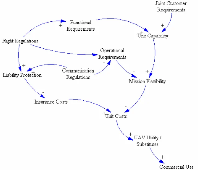
Many of the issues discussed above have strong interactions. Figure 1.1 is a brief summary of the primary system interactions. Market forces will continue to place pressure on governing bodies to adopt some regulatory framework for UAVs. The establishment of flight regulations will have a three-fold effect. First, flight regulations will likely increase functional requirements on UAVs, mandating some sort of “sense and detect” capability. Second, regulations should act to decrease operational requirements relative to the present. Current plans include the ability to “file and fly,” meaning that UAV operations will no longer be hindered by a 5 to 90 day filing delay. Given that “file and fly” is incorporated as part of a new regulatory framework for UAV’s, mission flexibility will be significantly improved. Finally, a set of well-defined rules and regulations will afford UAV operators some measure of liability protection. The backing of government agencies, either national or local, through the establishment of regulations will
thus drive down the insurance costs and ultimately unit costs of operating a UAV. The establishment of FCC regulations to govern the communications of UAVs will have similar effects on operational requirements and liability protection.
Figure 1.1: System Diagram
A set of joint customer requirements will also increase unit capability. These requirements can be gathered by UAV developers and manufacturers by estimating an initial target market and performing marketing focus groups and surveys. One issue that this diagram illuminates is the fact that the majority of potential UAV customers are completely unfamiliar with the technology and its wide range of applications. It can be difficult to obtain stable requirements from such customers. The benefit of joint requirements is that they will increase unit capability resulting in much greater mission flexibility; ideally, the same UAV platform can be used for a number of different applications for a wide variety of customers. Assuming scale effects common to the production of such systems, this flexibility would dramatically reduce unit costs.
A reduction in unit costs will help UAVs attain a utility level that will make them competitive with existing technologies and substitutes. The particular relative utility value is specific to the application. However, as UAVs become more competitive in each application, there will be increased opportunities for commercial use. In the more immediate future, UAVs will be employed to replace manned missions such as routine shipping operations and rural crop dusting. Replacing a manned vehicle with a UAV in such instances offers immediate cost savings and requires little additional operational overhead. Missions requiring automation on the fly and increased vehicle intelligence will follow later.
This diagram does not illustrate the potential interactions between increased commercial use and public perceptions of safety. The nature of this interaction depends on the success of the commercial applications. If the public’s first exposure to UAVs is negative, then there might be pressure on government institutions to expand regulatory oversight, thereby stifling further development until technology reaches such a level that the new safety requirements are met. The diagram also does not include the potential positive feedback between increased commercial use and more joint customer requirements. UAVs are a particularly interesting example of an emerging technology because already a number of regulations precluding their use exists, thereby hindering their expansion from military applications into commercial markets. Consequently, joint customer requirements are difficult to establish simply because so few potential customers have experience with the technology. Finally, Figure 1.1 does not illustrate the extent to which market pull is driving the adoption of UAV regulations. This link offers crucial insights into how the current trend to relegate UAV governance to the FAA can potentially be changed. Specifically, UAV manufacturers and consumers must be vigilant in establishing the rules under which the new commercial industry will function.
1.3 Objectives and Outline
As part of a larger research effort focused on the design, implementation, and demonstration of highly maneuverable rotorcraft UAVs, the primary objective of this work is to examine how UAVs might gain access to and function safely in civil and commercial markets. Despite the wide variety of existing UAVs in terms of size, targeted flight altitude, and capability, this work focuses primarily on small-scale tactical vehicles with the intended purpose of operating in and around urban centers. This document describes how operational requirements and risk mitigation strategies can be devised and effectively implemented to allow such UAVs to be operated at an acceptable level of risk.
The MIT helicopter project was used as a case study to illustrate the current state of urban tactical UAV technology as well as to provide a demonstration platform for commercial and civil missions. Chapter 2 provides a brief introduction to the work of the Information Control Engineering group of MIT’s Laboratory for Information and Decision Systems (LIDS). For the past 5 years, the group has been developing a highly maneuverable rotorcraft UAV for demonstration in a wide range of military and commercial applications.
A preliminary needs assessment is presented in Chapter 3. Through a series of meetings with Massachusetts State and Cambridge City officials, a set of requirements for the use of UAVs in civil emergencies has been developed. The needs assessment helped in generating three scenarios for the use of UAVs along with recommendations for an experimental platform. These scenarios illustrate how UAVs might be employed in emergency situations in a manner that optimizes the safety of civilians while complementing the needs of civilian institutions such as police and fire departments.
Chapter 4 provides an initial risk assessment and details how the risks introduced by UAVs might be controlled and mitigated. Preliminary calculations of implied vehicle reliability based on FAA requirements of a commensurate level of safety may be conservative and therefore limiting. Techniques in path optimization combined with detailed geospatial data concerning flight fields and areas of operation can be used to ensure that UAVs pose the least possible threat to the general public and urban infrastructure.
Policy recommendations based on the civil needs assessment and risk mitigation options are offered in Chapter 5.
Chapter 2
Case Study: The MIT Helicopter
MIT's Laboratory for Information and Decision Systems (LIDS) Helicopter Project is a research effort focused on designing, implementing, and demonstrating a highly maneuverable rotorcraft UAV for use in a wide range of military and commercial applications. The project has provided a platform for studying vehicle modeling, control system design and augmentation, as well as policy options concerning the integration of UAVs into present day regulatory frameworks.
2.1 History of the MIT Helicopter Project
MIT's Helicopter Project began as an effort to learn pilots' strategies for executing maneuvers by studying pilot commands to the vehicle in flight (Gavrilets – Autonomous Maneuvering, 2001). Since vehicle states were not recorded, this groundwork supplied limited insight into small-scale helicopter dynamics. The effort motivated an examination of the full state output of the helicopter to pilot inputs. Such data provides valuable insight into the dynamics of the vehicle in flight, thereby facilitating the development of models and controllers. An onboard data acquisition system is required to collect input-output data for a helicopter performing aggressive maneuvers. The instrumentation package must be capable of providing complete state information, such as velocity and attitude. Furthermore, the avionics design must accommodate both manual and automated control of the vehicle, while meeting the size, weight, vibration, and interference constraints.
The first introduction to MIT's instrumented, small-size helicopter equipped with a complete data acquisition system and capable of aggressive maneuvers was given in (Gavrilets, 2000). The development of this test platform enabled the first fully recorded acrobatic flight in July of 2000. During this flight, pilot inputs and the state information of the vehicle were recorded while the helicopter performed hammerhead maneuvers and loops. The data collected from such flights is extremely useful to build and validate the models that will be used to implement automated acrobatic maneuvers. The project focus then changed to the development and validation of a full-envelope helicopter model, as well as the design
of the feedback control logic used in autonomous acrobatic flight. In November of 2001 the MIT helicopter achieved the first fully autonomous acrobatic maneuver, completing three rolls without any pilot inputs. The project has since expanded in scope to include research into waypoint navigation, path-planning, and multi-vehicle coordination techniques. As the technological capabilities of the rotorcraft continue to improve, there is an increasing opportunity to demonstrate the commercial viability of the platform for use in both military and civil missions and to explore how similarly outfitted vehicles might be effectively employed for specific tasks.
Figure 2.1: The MIT flight vehicle equipped with avionics box
2.2 Flight System
The MIT flight system, shown in Figure 2.1, is composed of the helicopter, avionics system, flight control software, and ground station. The test vehicle is a derivative of an Xcell-60 helicopter manufactured by "Miniature Aircraft USA." The 0.9 in3 engine and carbon fiber frame give the craft a total weight of about
10 lb. While the basic rotorcraft is known for its reliability as a stable acrobatics platform, the avionics system is entirely custom designed. Mounted in a single aluminum enclosure suspended below the landing gear of the helicopter, the 7 lb. avionics configuration consists of a CPU, a power regulator, five sensors to provide closed-loop feedback, and batteries. All sensors, with the exception of a pilot command receiver and servo control unit, are commercial-off-the-shelf components and are rated as flight-ready. The onboard and ground station software is entirely implemented in C and runs on QNX 4.25, a popular real-time operating system. The high vibration levels of the rotorcraft, which can interfere with the operation of sensors and equipment, are attenuated by a passive vibration isolation subsystem,
which consists of an elastomeric isolator suspension system for the avionics box. The demonstrator platform is described in greater detail in (Sprague, 2002).
2.3 Capabilities
The MIT helicopter allows for three modes of operation: piloted, semi-automatic, and automatic. In piloted mode the helicopter is functioning simply as a radio-controlled vehicle, responding directly to the commands received from the pilot’s transmitter. Under pilot command, the helicopter is much more flexible in terms of its abilities to maneuver and perform precise movements. With the exception of potential signal loss, the craft remains under the complete control of a human operator for the duration of the flight. Although the piloted mode is arguably the perceived safest mode of operation, it also has a number of disadvantages. The aircraft is limited to flights within a certain range of the pilot and transmitter. This range is typically within about one mile due to FCC regulations on the signal power permitted in commercial radio transceivers. Another limitation on the range of flight and mission capabilities is that the vehicle must remain within the line of sight of pilot in order to facilitate flying. Pilots must also be heavily trained to effectively operate radio-controlled aircraft. Rotorcraft present a unique set of challenges for the pilot since they incorporate four axes of movement with fairly complex feedback structures and equations of movement. Finally, the piloted aircraft is subject to human mistakes and constraints and are thereby inherently limited in terms of flying time and failure recovery.
The addition of avionics to the flight system can mitigate some of these latter problems in terms of ease of flight and failure recovery. The MIT helicopter avionics box includes a GPS receiver to obtain positional data, an inertial measurement unit (IMU) which provides acceleration data for three axes of movement (x, y, and z), and an altimeter which provides a means of correcting GPS and IMU biases. The sensor data feeds into a control system which can then modify the interpretation of commands from the pilot’s transceiver and thus autonomously control flight dynamics. While any number of control systems is possible, the MIT avionics system currently features a semi-automatic controller which simplifies the dynamics enough that almost anybody is capable of flying the vehicle with little or no instruction. This control system decouples the flight variables and allows the pilot to send commands that translate to robust movements along the x, y, and z axes. The primary advantage of this controller is that the craft can be operated by almost anyone without requiring extensive training or experience. Under semi-automatic flight, the craft must still remain within range of the pilot and transmitter and must also be within the line of sight of the pilot. Furthermore, the addition of the avionics box and controller adds significantly more points of failure. A pilot trained in rotorcraft flight may still be needed for fault recovery.
An onboard avionics system is also a necessary prerequisite for fully autonomous flight, the final and defining mode of UAV operation. The MIT helicopter utilizes waypoint navigation techniques and programmed maneuvers, known as trims, to enable the vehicle to follow a predefined trajectory. The primary advantage of such a system is that the aircraft literally requires no pilot to monitor and control movements as long as the vehicle is capable of following a trajectory with a certain degree of reliability. Vehicles can be deployed at will to perform specific tasks with minimal supervision. While the MIT helicopter has demonstrated fully autonomous flight, including waypoint navigation and acrobatic maneuvers such as rolls and hammerheads, the operations have still employed a highly trained rotorcraft pilot as a fail-over.
2.4 Current Limitations
Despite its powerful capabilities for autonomous maneuvering, the helicopter is also subject to a number of constraints. The current flight time is limited to between 10 and 20 minutes, depending on how the vehicle is flown and the subsequent stress on the gas-powered engine. While the onboard batteries which power the vehicle’s servos and avionics significantly outlast the fuel tank, they are another limitation on the duration of flight operations. The battery lifetime is also dependent on the way the craft is being flown. Intense maneuvering and acrobatics drains both the fuel and servo batteries much more quickly than routine flight.
The payload capacity of the demonstration platform is also extremely limited. In cooperation with Draper Laboratory, flight tests were performed with a dumb weight mounted on the vehicle's landing gear. The tests demonstrated that the pilot is able to perform acrobatic maneuvers with a payload of up to 7 lb. Additional physical constraints on the system provide a lower bound on the weight of the payload. The avionics system must be immune to the numerous sources of vibration inherent in a small helicopter. The primary source of vibration on such a vehicle is the main rotor, spinning at roughly 27 Hz. Other sources of vibration include the engine, the tail rotor, and the tailboom bending resonance. These vibrations must be attenuated for an onboard sensor package to report reasonably accurate measurements, particularly in regards to gyroscope and accelerometer data. The control system must then be designed to fit into a single unit that is heavy enough for a passive vibration mount to be effective, but is light enough that the vehicle can still perform aggressive maneuvers. Simple calculations indicate that commercially manufactured elastomeric isolators can effectively attenuate the vibrations described above for a payload weighing more than 5 lb. (Gavrilets, 2000). The passive vibration mount also loses effectiveness if the payload is unevenly spread across the elastomeric isolators; the weight of the payload must be evenly distributed.
Since the existing avionics configuration weighs 7 lb., there is little additional payload capacity to allow for supplemental onboard instrumentation and sensors.
Given the constraints of the existing system, a new flight platform is currently under development for demonstration in civil safety missions. The demonstrator will feature flight times of up to 45 minutes and a payload capacity of about 15 lb. Though it lacks some of the agility of its predecessors, this vehicle will feature additional onboard processing capability which will enable it to execute real-time path-planning algorithms.
Chapter 3
Integrated Needs Assessment
While the MIT helicopter has demonstrated tremendous capabilities in terms of an augmented control system and autonomous acrobatic flight, these capabilities may not be sufficient to serve the needs of any specific commercial market segment. This schism between platform capability and customer requirements is bridged through a needs assessment. Unfortunately, the task of gathering customer requirements is difficult due to fact that most potential customers in the commercial and civil market segments lack of experience with UAVs. Leveraging their existing knowledge about and use of aerial mission support, civil safety institutions were targeted for an initial needs assessment. Institutions such as the police and fire departments also make sense as an initial market because many of the missions in which they might employ a UAV are inherently dangerous. Rather than focusing on the threats introduced by using UAVs in an urban environment, civil safety missions have the potential to demonstrate how UAVs can actually increase the safety of the general public.
3.1 Interviews
Interviews were conducted with Cambridge Mayor Michael Sullivan, MIT Chief of Police and former Massachusetts State Police Colonel John DiFava, and Cambridge Fire Chief Gerald Reardon to gather requirements for a UAV designed for use by civil institutions such as police and fire departments. These interviews provided valuable information about the operations of these organizations and offered insights into how UAVs may be able to serve some of their modern needs more effectively than current technologies.
3.1.1 Massachusetts Institute of Technology Campus Police Department (The Police at MIT, 2002)
The Campus Police at MIT subscribe to the traditional notion of crime prevention as “the anticipation, recognition, and appraisal of a crime risk and the initiation of some action to remove or reduce it.” This general goal is supplemented by a practice of crime risk management, which involves the development of systematic approaches to crime risk reduction that are cost effective and promote both the security and socioeconomic well-being of the potential victim.
Officers of the department have taken part in a variety of training exercises, including reactor training, CPR training, biohazard awareness training, firearms training, roll call training, officer safety programs, Massachusetts Criminal Justice Training Council courses, in-service training, diversity training, designer drugs training, criminal law procedure training, neighborhood crime watch training, motorcycle patrol training, firearms instructor training, and weapons of mass destruction training. A number of officers have also undergone additional professional development through courses on Criminal Offender Record Information and Law Enforcement Administrative Program Systems updates, racial profiling, gang violence and suppression, drug law enforcement training, combating underage drinking, and command training. Throughout the year, officers also attend a number of refresher courses to maintain their training as emergency medical technicians.
The MIT Police Department operates a total of 12 vehicles, including 5 marked cruisers, 2 marked motorcycles, 2 unmarked cruisers, a van used as a mobile command post, a class 1 ambulance, and a marked vehicle for prisoner transport, as well as a bicycle patrol unit consisting of 5 bikes. The marked patrol cruisers carry emergency equipment, which includes first aid kits, resuscitators with oxygen, flares, and other emergency items.
The department offers a wide breadth of services to the community. Community education and crime prevention measures include awareness packets, bike and laptop registration, lighting and security surveys, and seminars designed to disseminate knowledge and familiarize community members with officers. The department includes units which handle threat management, domestic abuse issues, rape and sexual assaults, and hate crimes and incidents. Figure 3.1 summarizes the department’s most frequently requested activities for 2002. In terms of service requests, Friday was by far the busiest day of the week with 1850 total requests. The next busiest days were Wednesday (1659) and Saturday (1652).
1 Directed Patrol Service 3737
2 Alarms-Security 1787 3 Lock Outs 884 4 Security Checks 709 5 Larcenies 635 6 Medical Shuttles 394 7 Fire Alarms 368 8 Field Stop 258 9 Escort Person 248 10 Suspicious Activity 245
3.1.2 Cambridge Fire Department (Reardon, 2003)
Massachusetts is unique in that, for funding purposes, the state is not subdivided into counties. State funding for safety programs such as the police and fire departments is allocated directly to the city in which the departments are based. One consequence of this structure is that the Cambridge Fire Department is the only fire department in a city that has up to 12 different police units (MIT, Harvard, Cambridge, AmTrak, MBTA, etc.). The Cambridge Fire Department is currently engaged in a long-term effort to integrate communications with all of these outlets. Most advanced development work is conducted in-house by a fulltime technical services group composed of 4 engineers and 3 mechanics. On occasion, the department will test out new equipment from their trusted suppliers.
The Cambridge Fire Department has an annual budget of about $28 million. The primary costs of running the department come from equipment, administration, and operations. There are two types of equipment units: ladders and engines. Each unit, including the staff of operators, costs about $300/hour. Limited revenues are generated through hydrant parking ticket fees, false alarm tickets, and equipment rentals. However, most of these sources are at cost; the department generates no profit from them.
Cambridge generates about 30,000 responses annually, one third of which are health-related issues. These responses also include the roughly 500-600 fires which take place each year within the city as well as hazardous material responses. Given that most responses take place under severe time constraints and represent an emergency, the department functions under an alarm system. Responses are categorized into alarm levels up to ten alarms. Each alarm level specifies the number and type of units to respond as well as where those units should come from.
Although the Cambridge Fire Department does not own any helicopters for use in responses, they employ vehicles from a number of institutions. A consortium of hospitals fund Medflight, which is a medical response unit used for emergency transport of individuals. Patients (or rather their insurance carriers) are billed through an integrated billing system, much as they would be for the use of an ambulance. Medflight flies out of Hanscom Air Force Base and Plymouth. The Fire Department also occasionally calls on the State Police Airwing Unit, which flies out of Norwood. The Airwing Unit is funded through a mutual-sharing agreement between the safety organizations. For the most part, the Airwing is used to obtain aerial views, forward-looking infrared, as well as to perform alpha-site work. Finally, the Coast Guard helicopters are sometimes called on in a similar support capacity.
3.2 Use Scenarios
The data acquired through interviews with the MIT police chief and the Cambridge fire chief is helpful in developing use scenarios for micro to miniature tactical UAVs in commercial and civil settings. These scenarios were developed based on actual situations described by Cambridge city officials. Some are adaptations of current military applications to a domestic urban setting. Due to the nature of the data collected, these use scenarios focus primarily on civil safety institutions, but can be easily translated to a number of commercial applications.
Several assumptions were used in the development of these scenarios. First, the cost of an urban tactical UAV is low enough that institutions can afford to maintain and operate their own fleet. This assumption is realistic, given that the present-day cost of acquiring micro or miniature UAV systems is relatively affordable and that the operating costs of these systems is much less than that of the helicopters currently employed by civil institutions. Secondly, the scenarios assume that regulations have been adopted which allow certified UAVs to be legally flown on an as-needed basis without requiring substantial, if any, lead-time. The UAVs involved are capable of flight times of at least one hour and are based throughout a city such that they can be deployed to the location of an emergency, perform a service, and return to base without needing to refuel. Finally, the UAVs are capable of vertical take-offs and landings. This last requirement is critical to the effective use of a UAV in an urban environment which lacks large open spaces for use as runways.
Police and fire department responses can be divided into two categories – those that require an immediate response and those that are not as urgent. These classifications provide a framework for developing the modes of transporting a UAV to a specific site. Open flight over an urban environment involves greater risk to the public at large than flight limited to small area already subject to an emergency situation. Thus, in situations in which the speed with which the UAV arrives on location must be no greater than the speed with which emergency operators are deployed, the UAV can be transported via a trailer or motor vehicle. While this mechanism of grounded deployment may result in a slower response time than if the UAV had been deployed through the air, it is also cheaper in terms of vehicle fuel and battery requirements, and provides more safety to the general public. In contrast, grounded deployment does not make sense in situations which require immediate deployment or involve surveillance over a large area. In these cases, the UAV should take off by air directly from base. Similarly, the mode of transporting a UAV back to base should take into account the remaining flight time available, the distribution of response forces, and the availability of complementary assets such as a mobile trailer to carry the vehicle back to base.
3.2.1 Surveillance and Video Reconnaissance
A truck containing sensitive biological and chemical materials must transport its cargo from a manufacturing facility to a secure storage warehouse on the other side of the city. The truck is equipped with a GPS tracking system which sends periodic position updates back to a central server. To facilitate the transfer the secure storage warehouse operators deploy a UAV to the location of the truck. Deployment takes place such that the UAV arrives at the manufacturing facility not more than 5 minutes before the truck is scheduled to depart. A trained pilot controls the UAV take-off and then switches to automatic control. The UAV ascends to an altitude of 150 meters, well above the highest structure in the pre-determined flight area and still within class G airspace. The UAV then flies directly to the manufacturing facility and hovers above the truck. As the truck pulls out and begins its journey, the UAV follows the truck’s GPS footprints and relays video back to the security office of the warehouse. From the vantage point of the UAV, the secure warehouse can monitor the movement of the truck, obtain visual feedback about security threats the truck may encounter, and gain advanced warning about traffic patterns so that the truck can be rerouted if necessary. As the truck pulls into the secure warehouse, the UAV is switched back to manual control by a trained pilot at the scene and landed.
3.2.2 Hazardous Situations
A fire breaks out at an apartment building resulting in an alarm sounding at the local fire house. The first firemen at the scene quickly deduce that the fire is already stronger than what they are capable of controlling. The fire is escalated to alarm level 3. Following alarm level 3 procedures, a number of other fire companies are called to the scene, including a UAV crew and their mobile trailer. At the same time that the crew is deployed, a rotorcraft UAV is relayed flight plan instructions directing it to the emergency location. The UAV takes off vertically from its base station, ascending to an altitude of 100 meters, well above the highest structure in the pre-determined flight area. The UAV travels immediately to the location of the fire where it proceeds to map out the hot spots of the fire by relaying infrared video from an onboard camera to a receiver operated by the UAV crew on their way to the scene. The UAV continues to monitor the fire’s activity either until the UAV crew issues new instructions or the vehicle senses that it must return to base for refueling.
By the time the UAV crew arrives at the apartment building, they have already communicated with the other crews deployed at the scene and have developed a strategy to battle the fire and evacuate the building based on the imagery from the UAV and the building blueprints. The UAV crew switches the UAV over to piloted control and lands it in a nearby yard. The UAV is refueled and returned to the mobile trailer where it is ready for immediate deployment.
3.2.3 Patrols
It’s late on a Friday night and a phone call comes into the campus police department reporting strange activity in the alley between the gym and the field. Since Friday nights are typically the busiest of the week, all of the on-duty patrols are out servicing other requests. Dispatch reroutes the on-duty department UAV from its general patrol of the campus to the gym to gain a visual on the area. The vehicle is one of two UAVs the department employs for routine patrols. The deployment of the vehicles is coordinated such that one can always be patrolling while the other is refueling. The vehicle receives its new commands through a wireless link to the onboard computer and immediately changes heading to fly to the new destination. Upon reaching the gym, the vehicle begins a circular search pattern, relaying high-resolution video back to the department dispatcher. Upon finding no further evidence of illegal activity, the dispatcher instructs the vehicle to obtain views of a couple more areas missed by the circular sweep and then decides that the reported activity was either a prank or a false positive. The UAV is released from the mission and returns to its patrol of the campus.
Chapter 4
Risk Mitigation
A key advantage of UAVs over their manned counterparts is the potential cost savings. Theoretically, a vehicle which does not need to support a human being can be made more cheaply than one which must guarantee the safety of the onboard operators. Simply in terms of raw equipment required onboard, a manned aircraft must both accommodate a human pilot as well as all of the gear needed to sustain the pilot’s life. By their very nature, UAVs require none of this special equipment. Similarly, since a system failure during a UAV mission is much less likely to result in casualties than a similar failure during a manned mission, UAVs should also provide a more operationally cost-effective alternative. While it seems intuitive that the safety requirements of UAVs be less rigorous than that for manned aircraft, the FAA insists that all UAVs meet a “commensurate level of safety.” At the same time, safety analyses performed by the FAA assume that the safety of the occupants onboard an aircraft guarantees the safety of the public on the ground. These methods of analysis cannot be immediately applied to UAVs resulting in ambiguity about what constitutes a “commensurate level of safety.” However, by applying the current methodology and safety targets used by the FAA, the implied criteria for UAV system reliability and fault tolerance can be deduced. Strategies and policy options can then be devised and evaluated to mitigate risk.
4.1 Preliminary Risk Formulation
Roland Weibel performed a preliminary risk analysis by focusing on the fatal hazards associated with UAV operation: high-energy ground impacts and midair collisions. His work offers a methodology for quantifying risk as a function of the mass of the UAV by using an order of magnitude analysis to compare the risk associated with fatal hazards to definitions of the FAA’s target level of safety (TLS). Based on this comparison, the requisite vehicle reliability to meet a given TLS can be determined in terms of failures per flight hours.
Target level of safety is a design criterion specifying the probability of the occurrence of adverse events. Events are classified as catastrophic, hazardous, major, or minor based on their severity. Each level of severity is then associated with a TLS which defines the probability at which each level of severity can occur. According to FAA guidelines, midair and ground exposure risks are classified as either hazardous or catastrophic. A hazardous event is defined by serious or fatal injury to a small number of occupants of the aircraft or fatal injury to ground personnel or the general public. Hazardous events have an associated TLS of 10-7 events per hour of flight. A catastrophic event is a failure which results in multiple fatalities
and/or the loss of the system. The TLS designated for catastrophic events is 10-9 events per hour of flight. Since these definitions may not be directly applicable to UAVs resulting in some uncertainty about the appropriate TLS, Weibel performed his analysis at a TLS of 10-8.
4.1.1 Ground Impacts
Focusing first on ground impacts, the fatality probability formulation is given by:
(
)
(
) (
P
Exposure
Incident
) (
P
Fatality
Exposure
)
hour
Incident
P
hour
Fatality
P
|
|
=
Where, (
)
hour
Fatality
P
is the fatal accident rate, or the probability of a fatal injury to a person on the ground per hour of flight. The fatal accident rate is determined by the TLS used in the analysis.
(
)
hour
Incident
P
is the vehicle reliability, or the hourly probability of an incident occurring on the vehicle resulting in a ground impact.
P
(
Exposure|Incident)
is the exposure probability, or the area-based probability that a person on the ground is exposed to a lethal field of debris from the colliding vehicle. This quantity is given by:(
Exposure
Incident
)
A
osureρ
P
|
=
expWhere,
A
exposure is the average area of lethality due to a UAV ground impact. Weibel approximated this as the frontal area of the UAV.
ρ
is the population density of the area, based on 2000 census data. P
(
Fatality|Exposure)
is the protection factor, or the probably of a fatal injury given thepopulation exposed to the vehicle at any point in time, recognizing that some persons will be protected by buildings and other structures.
Figures 4.1-4.3 illustrate the results of Weibel’s ground impact formulation when applied to modern tactical UAVs.
Figure 4.1: Ground exposure risk formulation applied to a UAV weighing 351 lb.
Figure 4.2: Ground exposure risk formulation applied to a UAV weighing 9.6 lb.
*Courtesy of Roland Weibel
Figure 4.3: Ground exposure risk formulation applied to a UAV weighing 2.12 oz.
The ground exposure risk formulation offers a preliminary estimate of the ground exposure risk associated with UAV flight across large regions. However, the preciseness of the formulation is severely reduced by potentially misleading population density data and critical estimates regarding the protection factor. Census data employs a hierarchy of spatial reporting units such that counties are divided into tracts comprised of groups of blocks. The block unit was originally defined to mean a city block, but variations in block unit size exist between rural and urban areas and across census regions. Occupied census blocks vary in size between 172 ft2 (16 m2) and 288 million ft2 (26.5 million m2), and between 0 and 4720 persons per block. Since population is tabulated at the block level and population density is computed based on the area of each block, the population density is largely dependent on the size of the block used. Some of the census blocks in urban areas are extremely small and thus yield very high densities. Furthermore, since population densities are based on location of residence, some blocks, both urban and rural, have a reported population of zero. A substantial number of these zero population blocks can be found at the core of urban centers. The lack of precision inherent to census data and estimates may mean that the resulting approximations of required UAV reliability are far more conservative than those actually mandated by the FAA.
4.1.2 Midair Collisions
Weibel also developed a framework for evaluating the risks associated with midair collisions. The formulation is based on the idea that from the perspective of a UAV, several airplanes transit through the airspace creating volumes of exposure. If any of these exposure volumes intersect the space-time path of the UAV, then a collision has occurred. The formulation relies on a number of assumptions. First, flights are assumed to be uniformly distributed between 0 and 10,000 ft. MSL, as well as uniformly distributed horizontally and throughout the day. Weibel’s calculations thus assume an equal likelihood of encountering an aircraft in any region of the National Air Space (NAS) at any time of day. A second assumption is that the velocity of the threatened aircraft is large compared to that of the cruising UAV, meaning that the UAV can be treated as static. Finally, the exposure area of the threatened aircraft is assumed to be equal to the frontal area of a Boeing 757.
The midair exposure risk formulation is given by:
(
)
(
)
air osureV
V
hour
Aircraft
N
hour
Collision
N
=
exp Where, (
)
hour
Collision
N
(
)
hour
Aircraft
N
is the rate of aircraft through the airspace which specifies the number of times the exposure area sweeps through the airspace.
V
exposure is the exposure volume. This quantity is given by: air osure osureA
d
V
exp=
expWhere,
A
exposure is the vulnerable area of the threatened aircraft in a collision with a UAV.
d
air is the distance traveled by the threatened aircraft through the airspace.
V
air is the volume of the airspace segment.Figure 4.4 illustrates Weibel’s analysis using Enhanced Traffic Management System aircraft surveillance data for a typical weekday.
Figure 4.4: Midair collision risk results
*Courtesy of Roland Weibel
While midair collisions do constitute a potential hazard in UAV missions, Weibel’s work is primarily applicable to UAVs routinely traveling through NAS. Tactical UAVs performing missions in and around urban centers within Class G airspace would never be expected to collide with an aircraft approaching the
size of a Boeing 757. Furthermore, the formulation only yields the probability of collision, assigning the same severity to the incident regardless of the collision momentum. This simplification can lead to misleading results; there are huge differences in the consequences of colliding with a manned aircraft between a stationary 10 lb object and a 4 ton projectile traveling at 450 mph, such as Boeing’s X-45 UAV.
4.1.3 General Shortcomings
While Weibel’s work establishes a good framework for evaluating the risks associated with UAV operation and offers valuable insights into generalized nation-wide risk mitigation strategies, his formulation lacks the granularity required to evaluate risks and develop mitigation strategies at the level of a city or urban center. Whereas the above analysis derived threat levels from relatively low-resolution population densities, a more granular approach could focus on high-resolution time-based population densities, critical buildings and structures, and areas of poor radio and GPS reception. Instead of deriving vehicle reliability standards for attaining a given TLS, a city-level risk assessment can highlight operational modes which maximize the safety of the general public and critical urban infrastructure. 4.2 Path Planning
The risk of a UAV causing injury to a person or building is strongly dependent on the path the vehicle follows between any two points. Flying over densely populated parks or sidewalks and streets where individuals are less likely to be protected by structures constitutes more of a threat to the general public than flying over structures and buildings. Similarly, flying around critical structures such as power plants and chemical factories is typically more risky than flying over or near office buildings. Though the probability of vehicle failure remains unchanged, the severity of a crash is primarily dependent on where the collision takes place.
4.2.1 Approaches to Path Planning
Path planning describes the problem of applying mathematical programming techniques to find the optimal path between two states for a single vehicle of a group of vehicles. The path can be optimized with respect to any cost function, typically fuel and/or time, and must guarantee that the vehicles do not collide with each other or with any of the defined obstacles, which can be dynamic or static. The use of potential functions has been the classic approach to robotic collision avoidance (Latombe, 1991). Additional techniques have included the use of randomized algorithms and graph searching and surface covering (Barraquand, 1997; Lozano-Perez, 1980). These approaches are limiting because they fail to take advantage of the full range of vehicle maneuverability, severely restricting the potential of