HAL Id: hal-00674647
https://hal.archives-ouvertes.fr/hal-00674647
Submitted on 27 Feb 2012
HAL is a multi-disciplinary open access archive for the deposit and dissemination of sci-entific research documents, whether they are pub-lished or not. The documents may come from teaching and research institutions in France or abroad, or from public or private research centers.
L’archive ouverte pluridisciplinaire HAL, est destinée au dépôt et à la diffusion de documents scientifiques de niveau recherche, publiés ou non, émanant des établissements d’enseignement et de recherche français ou étrangers, des laboratoires publics ou privés.
”Linguistic Geography of Breton and Sociocultural
Motivations”
Denis Costaouec
To cite this version:
Denis Costaouec. ”Linguistic Geography of Breton and Sociocultural Motivations”. STUF, Akademie Verlag, 2012, 65 (1), pp.47-64. �hal-00674647�
DENIS COSTAOUEC,2012,“LINGUISTIC GEOGRAPHY OF BRETON AND SOCIOCULTURAL MOTIVATIONS”,SPRACHTYPOLOGIE UND UNIVERSALIENFORSCHUNG65-1,BERLIN,
AKADEMIE VERLAG ,p. 47–64
Abstract
In this paper I discuss various issues directly related to the study of Breton dialects, and to the practice of linguistic geography. Some of the questions that will be considered are: Where does the border pass between two contiguous dialectal areas? How can the geographical distribution of the varieties of a language be explained? What factors (social, economic, cultural, religious, political, etc) can be correlated with this geographic distribution?
Keywords: Linguistic geography, dialectometry, dialectal borders, sociocultural motivations, Breton
1. Introduction
Based on the study of Breton (Celtic), this paper supports the hypothesis of a link between linguistic geography and the distribution of sociocultural features. This study is based on a previously undescribed Breton variety spoken in La Forêt-Fouesnant (COSTAOUEC 1998). It also draws on the linguistic material available in the Atlas linguistique de Basse-Bretagne edited by PIERRE LE ROUX (from 1924 to 1963). The methodology is based on a dialectometrical approach developed by GARY
GERMAN in his PhD thesis on the Breton of Saint-Yvi, Finistère (GERMAN 1984). A comparison of the phonetic material between the variety of La Forêt-Fouesnant (henceforth LFF) and the 77 points of investigation in the Atlas linguis-tique de Basse-Bretagne (hence ALBB) had made it possible to define the areas of dialectal proximity. Interestingly, the cartography of the phonetic distribution matches with the cartographies of matrimonial practices, traditional clothing, and choreographic repertories.
I begin with a short overview of Breton dialectology (section 1), followed by the methodology applied for this study (section 2). I then present the detailed linguistic results which are compared to some sociocultural practices. In section 4 I illustrate the linguistic and cultural parallel by a close look at two localities situated on the dialectal border. In section 5 I give some partial information on the northern border of the dialectal zone of strong proximity with LFF.
2. Overview of Breton dialectology
According to the mainstream literature (FLEURIOT 1980; GUYONVAC’H 1985; LAMBERT 1997; ABALAIN 2000 inter alia), dialectal limits of Breton follow the borders of the old dioceses of Western Brittany. This approach distinguishes the
varieties of the dioceses of Leon, Tregor, Cornouaille and that of the Breton-speaking part of the diocese of Vannes (Map 1).
Map 1: Dialectal areas of Breton (following the limits of the old dioceses of West-ern Brittany)
These four zones are clearly separated from the Gallo area (Romance) which starts to the east of a “linguistic frontier” (landmark A’ on Map 1). The border be-tween Breton-speaking and Gallo-speaking areas has been the subject of several studies (BROUDIC 1997 for a review), according to which the linguistic frontier has moved westwards over time, towards the extremity of Brittany (e.g. from A to A’). The border seemed to be stabilized by the end of the nineteenth century, along the linguistic line drawn by PAUL SÉBILLOT (1878). A recent study by LENORA A. TIMM (1980) showed that the border moved again during the last century. TIMM
noted that Breton in Basse Bretagne [the Breton-speaking area] appears to be “sur-viving in islands strung throughout a widening sea of French speakers’…” (TIMM
1980: 29). The “Sébillot Line” (A’), although dated, remains a reference. BROUDIC
(1997) has showed that this limit has not disappeared under the generalization of French in Brittany’s territory. Nevertheless, scholars prefer to think now in terms of restriction of Breton’s social uses, rather than in terms of reduction of its geo-graphical extension (TIMM 1980, BROUDIC 1995, COSTAOUEC 2002).
Dialectal distinctions based on diocesan boundaries have certain socio-historical motivations. Indeed, since the tenth century the dioceses were the institutional framework of Breton life and kept this role until the French Revolution of 1789. Moreover, part of the Catholic Church in Brittany (Jesuits being most active in this field) applied the so-called règle d’idiome (the use of Breton, instead of French) in pastoral activities, namely for preaching, confession and catechism (MINOIS 1991). This choice was not obvious for the Catholic high clergy and it caused internal
1 2 3 4 1: Leon; 2: Tregor 3: Cornouaille 4: Vannetais A’: “Ligne Sébillot”
(linguistic border) B: “Maximal Exten-sion” of Breton (9th C.)
A’
B
Gallo 30 kmA
debates and hesitations (LAGRÉE 1992). The règle d’idiome implied everyday in-teraction in Breton between priests and parishioners and gradually led to some de facto Breton standards, mainly specific to each diocese. The importance of the linguistic factor in Church organization can be illustrated by the ancient division of the diocese of Saint-Malo between its Breton-speaking area and its Gallo and French-speaking area. Furthermore, numerous religious documents in Breton (mis-sals, catechisms, prayer books, etc.) were published under bishops’ authority (L A-GRÉE 1992, COUROUAU 2008). In general, the authors, often also priests, chose written forms close to the dialect of their parishes.
Still, dialectal varieties do not correspond entirely with diocesan territories. Al-ternative cartographies were proposed, identifying intermediate linguistic areas between the large traditional dialectal areas. These transitional zones are indicated by hatching on Map 1. One can find, sometimes, on such maps a reference to a historical eastern limit of the Breton’s geographic extension during the ninth cen-tury (landmark B on Map 1). Following LOTH (1893) this line is considered the historical limit between Celtic and Romance domains, as a result of the Breton immigration from Wales and Cornwall between the fifth and seventh centuries. FALC’HUN (1963, 1981) has challenged this analysis by arguing that LOTH’s line marks a stage in the French expansion within the ancestral Celtic domain. For FALC’HUN, the course of this linguistic line, which incurves westwards under the influence of the French-speaking cities of Rennes and Nantes, could rather attest the expansion of French.
The most radical and productive theory in Breton linguistic geography has been developed by FRANÇOIS FALC’HUN, in Histoire de la langue bretonne (FALC’HUN
1963). Working on data from LE ROUX’s atlas, FALC’HUN clearly identified three distinct dialectal areas: The first one to the north-west (mainly corresponding to the area called Leon); the second one to the south-east (the Vannetais); the third one in the vast central zone which extends from the south-west peninsulas (Pays big-ouden) until Tregor on north-east (Map 2 below).
FALC’HUN showed the importance of economic exchanges in the gradual ad-vance of linguistic changes within the central zone (including influences of French). He also pointed out the decisive role of the town of Carhaix (indicated by the arrow) in the diffusion of the innovations which distinguish the central zone from the two peripheral areas. This town is located at the heart of the Breton-speaking Brittany, where the most important trade routes crossed.
Map 2: FALC’HUN (1981) Fig. 6: Breton dialectology. The central area and the peripheral zones
3. Methodology for measuring dialectal proximity
The main task of linguistic geography is to locate and compare linguistic varia-tion, usually dialectal variation. However, dialects are not consistent units that are sharply differentiated from neighbouring dialects and dialectal phenomena are rarely exclusive to a single dialect. Isogloss networks clearly show this reality. Maps in the atlases, even “second generation maps”, cannot answer a simple ques-tion: How much do two dialects differ? This question leads to a new set of meth-odological and theoretical problems: What is a good indicator of dialectal differ-ence? Does this indicator make it possible to compare a specific local variety with other points of investigation in an atlas for example? Does this indicator allow for dialectal differences to be measured?
These are well-known questions for scholars working in dialectometry. The term dialectométrie was introduced by JEAN SEGUY (1973) into Romance studies. Nowadays, it refers to a type of analysis of linguistic atlases’ data using mathe-matical und visual methods borrowed from statistics, numerical quantitative classi-fication and modern computer-assisted cartography, with the aim of measuring and analyzing linguistic similarities (and distances) between the inquiry points of the atlas on study (GOEBL 2002, 2005, 2006). The goal of dialectometry is to advance our knowledge in the domain of diatopic networks, the space component of the general linguistic change. Teams of linguists, in Austria, the Netherlands and the USA, have developed methods for computerized data-processing. Moreover, HANS
GOEBL and his team also proposed an original theoretical framework called “Basilectal management of geographic space by Homo loquens” (GOEBL 2002, 2010). Dialectometry is thus a very active and productive field of study in linguis-tics.
South-East Central area
(and Carhaix)
My project, far from the sophisticated means implemented in modern dialecto-metry (as the ‘Levenshtein algorithm’ used in Groningen; NERBONNE &HEERINGA
2001), was based on simple considerations and semi-manual processes.
The issue of the available linguistic material was crucial. The Breton-speaking area is only incompletely described in monographs (Map 3) and there are no linguistic studies available for most of the territory, notably for the area described by the pre-sent work. Besides the rare monographs, one can find some studies on folklore or vocabulary, of uneven quality, regularly published since the end of the 19th century1.
Map 3: Distribution of monographs and specific studies on Breton dialects
Nevertheless the most reliable and exploitable data come from a set of linguistic atlases:
LE ROUX,PIERRE (1924–1963): Atlas linguistique de Basse-Bretagne, 6 volu-mes, 77 points of investigation, 600 maps.
LE DU,JEAN (2001): Nouvel Atlas linguistique de Basse-Bretagne, 2 volumes, 187 points of investigation, 600 maps.
LE BERRE, IWAN & LE DU, JEAN (dir.) (2008): Ichtyonymie bretonne. Atlas linguistique de la faune marine en Bretagne. Trilingual version: French, En-glish, Breton. Brest: CRBC and IUEM, Université de Bretagne occidentale. On DVD.
ROLAND,PASCAL (1994): Atlas linguistique de la région de Pontivy, Morbihan – Côtes d’Armor, 2 vol.
LE ROUX’s pioneering atlas follows the principles established by GILLIÉRON for the Atlas linguistique de la France (GILLIÉRON &EDMONT 1902–1910). It presents “first generation” maps on which the linguistic forms collected during fieldwork are phonetically transcribed in Romanists’ alphabet (Map 4).
1
For an updated list of studies on Breton’s dialects, see the personal Website of the linguist LOÏC
CHEVEAU: www.loig.cheveau.ifrance.com Monographs Specific studies
Unlike FALC’HUN who treated LE ROUX’s data to define isoglosses, GARY G ER-MAN’s specific method of analysis consisted of observing phonetic differences between lexical or grammatical forms in Saint-Yvi and the points of investigation of the atlas. Following GERMAN, I wanted to identify the “dialectal gap” between each one of the 77 points of investigation in LE ROUX’s atlas and La Forêt-Fouesnant (which was not a point of investigation in the ALBB).
Map 4: ALBB by LE ROUX. Map 1 Points of investigation. Localization of La Forêt-Fouesnant
The method consists of allotting numerical values to the phonetic differences and similarities between the reference dialect and the 77 other localities. This allowed demarcating different geo-dialectal areas according to their average score. This method was based on the following hypotheses:
A consonant which appears in a precise phonetic context, in a stable way, in a well defined area, has a great probability of having occupied this place for a long time.
According to this hypothesis, phonetic differences would indicate dialectal dif-ferences.
This would allow identifying an indicator of dialectal proximity between the reference dialect and the other localities.
The theoretical justification of this hypothesis rises from the basic principles of linguistic reconstruction (LEHMANN 1992; BEEKES 1995) concerning the relative diachronic stability of consonants.
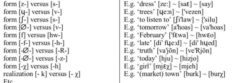
In Table 1 I present some of the simple phonetic criteria I used for the compari-son. As it is noted, this is a basic system compared with the available tools for modern dialectometry:
form [z-] versus [s-] E.g. ‘dress’ [ze:] ~ [saɛ] ~ [say] form [ɥ-] versus [v-] E.g. ‘trees’ [ɥe:n] ~ ['vezen] form [ʃ-] versus [s-] E.g. ‘to listen to’ [ʃi'law] ~ ['silu] form [-] versus [v-] E.g. ‘tomorrow’ [a'hoas] ~ [va'hoas] form [f] versus [hw-] E.g. ‘February’ ['fɛwa] ~ [hwɛo] form [-f-] versus [-h-] E.g. ‘late’ [di' fɥe:d] ~ [di' hɥed] form [--] versus [-R-] E.g. ‘truth’ [va'jõn] ~ [ve'Rjõn] form [--] versus [-z-] E.g. ‘today’ [hju] ~ [hizjo] form [-χ] versus [-h] E.g. ‘girl’ [mjɛχ] ~ [mjeh]
realization [- k] versus [- χ] E.g. ‘(market) town’ [burk] ~ [burχ] Etc.
Table 1: Some criteria used for phonetic comparison
Numerical valorisation of the phonetic differences was based on a simple princi-ple: when the form under examination was dissimilar from a form attested in La Forêt-Fouesnant, it scored “1”; when the forms under comparison were similar, the value was “0”. Each difference was noted and, for the same item, the score of a point of the ALBB could vary from 0 to 2 (3 for some rare cases) Thus, the more a point of investigation differs from the reference point, the higher its “score”. This is illustrated in Map 5, below, showing the exploitation of the ALBB’s item n° 298, ‘Trees, a tree’. The data processing was carried out with Microsoft Excel spread-sheets, on the basis of about half of the atlas’ maps. That means that more than 35,000 forms were examined, corresponding to less than 500 items2. I give below an example of the exploitation of Map n° 298 in the ALBB:
La Forêt-Fouesnant form for ‘tree’ is [ɥe:n] ([ẅĕ̩ n] in LE ROUX’s transcrip-tion), to be compared with other dialectal forms:
Criteria and values
Point Name Form [ẅ-] ~ [v-] [ẅ-] ~ [gẅ-] [-Ø-] ~ [-z-] [-Ø-] ~ [-h-] Total
49 Elliant [ẅĕ̩ n] 0 0 0 0 0 53 Clohar-Fouesnant [ẅē n] 0 0 0 0 0 54 Nevez [ẅē n] 0 0 0 0 0 55 Tréméven [ẅĕ n] 0 0 0 0 0 52 Plomeur [vĕ n] 1 0 0 0 1 48 Pluguffan [vĕ n] 1 0 0 0 1 46 Plouhinec [ve̩̍zen] 1 0 1 0 2 36 Crozon [ve̩̍zen] 1 0 1 0 2 1 Ouessant [ẅe̩̍zen] 0 0 1 0 1 4 Saint-Frégant [ve̩̍zĕ n] 1 0 1 0 2 63 Noyal-Pontivy [ẅe̍he̩̍n] 0 0 0 1 1
66 Saint Allouestre [gẅe̍ẓe̩̍n] 0 1 1 0 2
Etc.
2
I put many items aside when the forms under study were too different to be analyzed in terms of phonetic differences. It is the case for lexical forms like mintin/beure ‘morning’ (Map n° 30 in the
Table 2: Analysis of Map n° 298 “Trees, a tree” (example scores) 3.1 Cartographic representation of the results
Map 5 (below) represents the space projection of the scores obtained for the vari-ous points of investigation in the ALBB, for the item “Tree”. This map shows some interesting groupings. Zone 1 located near LFF presents scores at 0, i.e. of null dif-ferences with the reference point. Zone 2 shows tiny difdif-ferences and could almost be added to zone 1. On the contrary zone 3 shows the most important differences (ma-jority of 2). Between these definitely distinct areas there is a central zone largely open to the east and north-east. For this map, the Breton variety of LFF presents great similarities with the Vannetais’ forms. This is not the case for all the items I treated, but it appears that there are indeed appreciable affinities between LFF and the varieties located to the centre-east of the Breton-speaking area.
I made this kind of analysis for the ALBB’s maps I had selected and I transferred the total score for each point of investigation to an intermediary map. Then I calcu-lated the average score by zone (rounded up results are showed in Map 6 below). Defining the geographical limits of these zones was a crucial issue. The 77 points of investigation in the atlas form a loose network. I considered in an arbitrary way that the results obtained for a point of investigation applied to a group of 4 or 5 neighbouring rural districts (that is a canton in the French administrative division). On the maps I present then boundaries between dialectal zones that follow group-ing of cantons. This is a debatable choice: the canton is an administrative entity but nonetheless it can be quite homogeneous geographically and culturally; however in several occasions, dialectal borders are fuzzier and do not correspond to adminis-trative limits. This solution does not indicate where the frontier between two neighbouring dialects is located. I will develop this issue in section 5, below.
1
2
3
Map 5: Analysis of the ALBB. Map n° 298 “A tree, trees”
Map 6: Distribution of the dialectal zone following our analysis (average of pho-netic differences with the reference point La Forêt-Fouesnant)
Map 6 illustrates the distribution of dialectal areas I obtained by this method. A zone of strong proximity (average difference 100) is located in the vicinity of LFF, including the commune of Saint-Yvi which GERMAN studied (not shown on this map). A zone of low-ranked differences (average score 350) extends around it. To the northwest stretches a zone of greater differences with LFF (indicator = 1000). To the north extends a zone the average of which is 750. To the southeast, the Van-netais is also a zone of important differences (indicator = 700). To the southwest, towards the Pointe du Raz and the Pays bigouden there is another high score area (indicator = 700). A zone of medium differences (500-550) stretches through the Breton-speaking area, along a southwestern / northeastern axis.
Except for the territories of the south-western point of Brittany (indicator = 700), the results agree in a remarkable way with FALC’HUN’s conclusions. It can be con-cluded from these observations that the exploitation of data from LE ROUX’s atlas by different methods leads to convergent results.
Results are more convincing if translated to the form of a “gradient of dialectal difference” (Map 7). A gradient is a rate of variation of a value according to a pa-rameter. The concept of “champ gradient de la gasconnité” was introduced by S E-GUY (1973) to describe the spatial organisation of the Gascon-speaking area. This concept was taken up and theorized by GOEBL as a “matrix of (dialectal) similar-ity” (GOEBL 2006). On this basis it is possible to build “maps of similarity” which
750 1000 700 700 350 650 550 500 600 LFF 650
constitute the central heuristic axis of the Salzburg’s school of dialectometry (GOEBL 2006). Once again, my approach looks simplistic compared with the mathematical tools developed by dialectometricians. I compared variation in the number of phonetic differences and the geographical distance between LFF and a point arbitrarily situated in the middle of the zone under consideration. The “for-mula” is then: Number of differences divided by Distance LFF/Point X (in kilome-tres). Map 7 shows the result of this calculation.
Map 7: “Gradient of dialectal difference” between LFF and the different areas One can expect of course that geographically distant zones present important phonetic differences with the point of reference. This is the case for the northwest-ern area in term of raw results (indicator = 1000). In term of “gradient of dialectal distance” things are different: the northwestern zone has a relatively low gradient (13), according to its remoteness from LFF, while much nearer zones show high gradients (e.g. the “550” zone to the north of LFF, gradient = 33, or the “650”, “700” zones towards the point of Brittany, gradient = 28 and 18). That means that, for the mode of comparison chosen here, important phonetic differences occur over short distances, showing sharp dialectal discontinuity. Interestingly, the gradient is very low for the eastern zone (Vannetais): that can be correlated with cultural fea-tures which suggest a linguistic continuity between the zone close to LFF and the south-east of the Breton-speaking area. Such data, which I did not exploit until now, need to be corroborated by more refined calculations and to be checked against studies of the literature and additional fieldwork.
11 13 18 9 28 33 5 12 7 6 LFF
4. Focus on the zones of strong similarity
I will focus now on a zone of strong similarity with La Forêt-Fouesnant Breton, which corresponds to average differences equal to or less than 100 and to the “350” zone (Map 8, next page).
The “100” area includes the territories of two complete cantons (that of Fouesnant and Rosporden) and part of two other cantons (Scaër and Concarneau). In GERMAN’s work the “110” zone (strong proximity with Saint-Yvi’s variety) was oriented perpendicularly to the coast. The “100” zone whose reference is LFF has a more coastal extension (hatched surface on Map 8), but also stretches as far as the rural town of Scaër to the northwest. Observed on large scale, the geographical limits of this zone are to the west the Odet River to the east the Aven River. The northern border is more interesting because no major topographical obstacle marks it. I am more interested in this limit in the present study.
The “350” area (weak differences) stretches to the east and slightly to the north of the zone of strong proximity (Zone “100”). On seaside, the eastern limit is the Laïta River, and the border continued north along the Ellé River, an affluent of the Laïta. Further, to the east, the indicator passes abruptly to 700, without transition. The “350” area corresponds more or less to the traditional broioù (in French “pays” i.e. culturally homogeneous areas), the Bro Aven, the Bro Chtou and partly to the Bro Pourlet (Map 8, small map on the left).
Map 8: “100” and “350” areas around La Forêt-Fouesnant (small map on the left: 3 traditional Broioù: 1 Aven, 2 Chtou, 3 Pourlet)
4.1 Covering of cartographies
I will now show that the limits of the “350” area largely follow those of certain local cultural phenomena. FALC’HUN (1963) had already suggested a possible over-lap between the dialectal areas and the zones of Breton traditional dress. GARY
350 100/110 St-Yvi LFF 500 700 Odet R. Aven R. Laïta R. 1 2 3 LFF
GERMAN had made the same observations in connection with the zone around Saint-Yvi. I illustrate the phenomenon by extending the comparison to the cartog-raphy of the various types of traditional dance and to the cartogcartog-raphy of the geo-graphic origin of the spouses of some Breton speakers from LFF (COSTAOUEC
1998).
Map 9 shows the territory of the traditional headdress known as Giz Fouen (in the style of the town of Fouesnant, in Breton), characterized by a broad collar, important wings and long ribbons. Beyond this limit, the headdress’ form changes radically, that is to the west on the right bank of the Odet River, to the north towards Quimper or to the east. In fact the so-called Giz Fouen has spread into the zone of influence of the town of Rosporden (CRESTON 1978). Nowadays Rosporden is a small town of little importance, but formerly it has played a major role because it was located at the junction of two important commercial roads, one covering the southern part of Brit-tany, the other leading towards Carhaix and the northern coast. Rosporden had an important cattle fair and it was also a centre of diffusion for manufactured goods in the area (in particular cloth fabrics), therefore a point of diffusion of innovations within the rural world of the area. Rosporden’s influence has been particularly im-portant during the second half of the nineteenth century in the standardization of local cultural behaviours (OGÉE 1843; CORNETTE 2005).
Map 10 shows the zone of extension of a style of dance called “Bal de l’Aven”. This dance is executed by groups of two couple of dancers, whereas the older dances are almost always carried on in chains. It adopts a slipped step, very differ-ent from the dynamic and hopping style of the “Mountains’ gavottes” (to the north). The style originates from the area of the town of Pont-Aven (GUILCHER
1963) and has spread gradually into a vast zone as far as the Odet River to the west. On the right bank of the river the “bigouden style” with marked differences is most common. To the east of the Laïta River begins the area of dances in chain (andro and hanterdro), characteristic of the Vannetais.
A comparison between Maps 9 and 10 (next page) shows that the two cultural features’ areas follow almost the same layout, except for two places. The Giz Fouen does not extend to the east towards the town of Roudouallec or towards Clohars-Carnoët (along the coast). But the “Bal de l’Aven” was propagated to the south. In the north-east, a zone pertaining to the “350” area does not seem to be concerned by the Giz Fouen nor by the “Bal de l’Aven”. This area corresponds more or less to the zone of Roudouallec (point n° 44 on the ALBB). In this case, dialectal features show great similarities with the other points of investigation in the “350” area, while cultural features are divergent. Here the limit of geographical representation on the basis of the cantons is apparent. The dialectal border goes certainly through Roudouallec, leaving other communes of the Bro Chtou apart from the “350” zone. This is true in particular for Gourin which is characterized by a particular clothing style and which is attached, from the choreographic point of view, to the “Mountains” style (dances in chain).
Map 9: Extension of the Giz Fouen (Rosporden’s or Fouesnant’s headdress)
Map 10: Extension of the dance style “Bal de l’Aven”
Map 11 represents the distribution of the places of birth of the spouse, non born in LFF, of some Breton-speakers of the village. In a remarkable way, the majority of the people were born in communes belonging to the “350” zone. Once again, the northeastern zone of the “350” area is conspicuous.
“Bal de l’Aven”
Clohars-Carnoêt
?
Roudouallec
Pont-Aven
Rosporden
Map 11: Place of birth of the spouses –non born in LFF– of some Breton-speakers of LFF (COSTAOUEC 1998)
The comparison of these various maps shows an important linguistic and social cohesion of the population in the area: speaking appreciably the same variety of Breton, locals also adopted the same clothing fashion during the nineteenth cen-tury, they also adopted the same style of dance and, finally, they practiced an areal endogamy… An impression of cultural convergence thus emerges which subsumes the differences which are observable on the field.
4.2 Factors of homogeneity in the area 4.2.1 Geographical unity
The “350” area is characterized by its territorial continuity. It presents few natu-ral obstacles to the east. Upstream from the town of Pont-Aven, the Aven River was not an obstacle to land circulation; its downstream part is navigable and was a shipping route. The southernmost limit of the zone is the coast. Sea transport of-fered important possibilities of contacts between the coastal towns and the eco-nomic centres accessible by waterway like Pont-Aven or Quimper, but part of the coast between Concarneau and the Aven River mouth is inhospitable.
The Odet River seems to constitute a clear border to the west. Until the end of the twentieth century people had to go to Quimper, 15 km from the shore, to find a bridge over the river, and towards the mouth, only a small ferryboat crossed be-tween Bénodet and Sainte-Marine. However, the Odet River was a major trade route, used by an important fleet. Geography plays a less important role than his-tory here. Before the Roman conquest, the border between Gallic peoples, Osismes and Venètes, fluctuated and was disputed, but territories to the west of the Odet
River have always been under Osismes’ domination (GIOT et al. 1995). The eastern zone extending to the Aven River was influenced by the Venètes, though officially in Osismes’ territory. The Odet River thus constitutes an ancestral cultural border between two major parts of Breton-speaking Brittany. On the whole, the zone “350” seems rather permeable to eastern influences, towards the Vannetais, where-as the dialectal border seems firmer to the west and the north-west.
4.2.2 Economic unity
The zone has an important agricultural tradition. Until now small-scale farms dominate, which practice breeding and “second rank” farming like oat, rye, potatoes, etc. Under economic conditions prevailing during the years 1858–1880, a period in which the large-scale agriculture slowed down (culture of corn and industrial crops in particular), Breton agriculture paradoxically experienced an important success (DÉSERT 1976). Then a period of relative prosperity started for farm owners and for servants and farm labourers as well. During this period many estates changed own-ers, making the networks of exchanges and solidarity within the rural world more complex. The number of farm owners increased while that of the sharecroppers de-creased. The improvements in the economic conditions at the end of nineteenth cen-tury supported an increase in families’ consumption, which, for example, spent more for purchasing manufactured products like cloth fabrics or soft furnishings. This resulted in a great diversification of clothing fashions (CRESTON 1978), with sharp distinctions between traditional cultural areas. In part of the “350” area, one result was the extension of the expensive and sophisticated Giz Fouen.
4.2.3 Religious unity
As everywhere in Brittany, in the “350” zone Roman Catholics were in the ma-jority and religion has been a strong social bond. However, if faith was deep, inter-est for ecclesiastic functions was moderate in the area. GEORGES MINOIS (1991: 103) has published a map which shows data on priests recruiting in Brittany at the end of the nineteenth century. The “350” area provided few priests: one for more than 1250 inhabitants, compared with the Leon area for example (1 priest for 500 inhabitants). Furthermore, in this “350” zone, the Mass attendance moved back strongly in the 1960’s, more than in other areas in Brittany.
4.2.4 Influence of the cities
This is probably a determining factor for the convergent/divergent evolution of the cultural practices in the zone, and perhaps for the linguistic practices. The role of the town of Rosporden seems central, owing to its geographical localization and its commercial influence. It is not surprising that its clothing style could have spread throughout its zone of economic and social influence and its role was deci-sive too for the westwards diffusion of the “Bal de l’Aven”. Contrary to the ho-mogenizing role of Rosporden, the city of Concarneau was a factor of differentia-tion. As a harbour and an old military garrison, the city was open to the Atlantic coast and became a French-speaking enclave very early. This city played a major
role in the process of progressive domination of French in the area, and reinforced the distinction between inland territories and the coast.
5. Where does the border go?
As GASTON TUAILLON stated (1976: 82), the dialectologist seeks “to establish a stable dialectal border to allow the mind to form a clear picture of the complex play of the interesting linguistic correlations woven between the dialects” [my transla-tion]. Indeed, the layout of the borders between dialectal areas does matter because it partly determines the possibility for causal analyses. For the “350” area, the most problematic borders are to the north and the north-east and we need more detailed information on these places. I began systematic fieldwork in the rural districts which seem to be involved in the limits of the “100” area. I will present some observations on two communes “on the border” Elliant and Tourc’h (Map 12 below).
Both of communes are still active agricultural rural districts. Elliant is very wide and is crossed by the Jet River, which delimits two quite distinct zones: lowlands and plateau. Tourc’h stretches along a north-south axis. A part of the village stretches to the north of the Aven River, which is only a thin brook in this place and which barely marks the relief.
I investigated these two communes with farm owners. They are mainly dairy farmers, but in the lowlands most of the farms breed pigs. The working hypothesis I checked was that, as these farms belong to the same families for several genera-tions, their current occupants can provide information on the networks of mutual aid which functioned in the area before the important transformations of agrarian techniques during the last fifty years. The observation of these social networks, as well of the traditional trade circuits, can provide information on the distribution of the territory between various parts of the population and perhaps help us to identify the basis of dialectal differentiation.
In Elliant the investigation, though rapid and incomplete, applied to farms of the plain and the plateau. The essential observation is that the networks of cooperation between farms (which are old memories now) were limited to the immediate prox-imity and an almost complete split existed between the farms on the plateau and those on the lowlands. For example, a farm called Kerho, overhanging the town cen-tre of Elliant and very close to the river, did work only with the close farms on the plateau. Incursions into lowlands were limited to graze the cattle along the river.
In Tourc’h, the zone to the north of the Aven River was clearly distinct from the other part of the rural district, farms being held by close relatives who were accus-tomed to work together, without extending this cooperation to the farms of the south side.
Moreover, farms on Elliant’s plateau as well as farms to the north of Tourc’h had commercial relations with the town of Coray, whereas farms located on the low-lands and to the South traded usually with Rosporden (Map 12).
Map 12: Elliant and Tourc’h, on the dialectal border of the “100” area
The image which emerges is that of communes whose administrative limits do not match with the reality of social networks and circuits of exchanges within the population. An economic and relational border cut the villages in two, each part having its own tropism. Can we infer from the observation of such features that they are correlated with dialectal distinctions? Certainly not in such direct terms. But it should be admitted that close populations, pertaining to the same parishes, living in the same municipalities, could have been involved in distinct social net-works for a long time. Such a situation could have led to dialectal differentiations, being organized according to the attraction of two economic centres, Coray and Rosporden, each one being the heart of a zone of economic and cultural diffusion, possibly also at the origin of a complex process of dialectal homogenization or differentiation.
To evaluate the assumptions which remain, we have to continue with investiga-tion along the assumed dialectal border. We have to carry out a meticulous dialec-tological survey with the last native speakers to check if historical economic, social and territorial differentiations correspond to linguistic differentiations.
Tourc’h
Elliant
Rosporden
Coray
Jet River
Jet River
Aven River
5. Conclusion
I tried to illustrate in this paper the interest of a renewed analysis of data from LE ROUX’s ALBB. My exploitation of the concept of “gradient of dialectal differ-ence (or proximity)” remains embryonic, but by using modern dialectometrical tools it could be possible to develop this research even further.
The bond between dialectal and cultural features seems obvious. Until now how-ever there is no proof to establish causal relations between the two orders of phe-nomena. Complementary studies have to be carried out. Fortunately, we have for Basse-Bretagne the recent NALBB by JEAN LE DÛ, complete with digitized data. Their exploitation according to an optimized version of the procedure suggested here would result in a wealth of information. It would then be possible to compare any Breton dialect with all the points of the atlas and with the points for which linguistic material will be collected in the future.
A rigorous scientific debate has to be organized on the comparison criteria, those with mine being too rudimentary. In particular we need to define criteria of weight-ing for the phonetic features that should be retained.
Fieldwork has to be carried out, in particular along the assumed dialectal frontiers, in order to improve our knowledge of the dialectal variation. A better use of regional and local history is necessary. We have to promote collaboration between linguists, anthropologists, historians and mathematicians to build the tools which will make it possible to model the social networks (including kinship) which seem to play a cru-cial role in the processes of dialectal differentiation and homogenization.
References
ABALAIN,HERVE (2000): Histoire de la langue bretonne. Paris: Editions Jean-Paul Gisserot.
BEEKES,ROBERT S.P. (1995): Comparative Indo-European linguistics. An introduction. Amsterdam: John Benjamins.
BROUDIC,FAÑCH (1995): La pratique du breton de l’Ancien Régime à nos jours. Rennes: Presses
Universitaires de Rennes.
BROUDIC,FAÑCH (1997): À la recherche de la frontière. La limite linguistique entre Haute et
Basse-Bretagne aux XIXe et XXe siècles. Brest: Ar Skol Vrezoneg.
CORNETTE,JOËL (2005): Histoire de la Bretagne et des Bretons. 2 t. Paris: Seuil.
COSTAOUEC, DENIS (1998): Le breton parlé à La Forêt-Fouesnant (Finistère). Pratique actuelle,
problèmes de phonologie et de syntaxe. Ph D thesis (n.p.). Paris: Université Paris 5.
COSTAOUEC,DENIS (2002): Quel avenir pour le breton populaire? Enquête à La Forêt-Fouesnant. Brest: Brud nevez. Coll. Leoriou bihan.
COUROUAU,JEAN-FRANÇOIS (2008): L’imprimé religieux en langue bretonne (1526–1660), in: Annales
de Bretagne et des Pays de l’Ouest 115-3. Rennes: Presses universitaires de Rennes, 57–79.
CRESTON,RENE-YVES (1978): Le costume breton. Paris: Tchou.
DESERT, GABRIEL (1976): Prospérité de l’agriculture, in: DUBY,GEORGES &WALLON,ARMAND (dir.),
Histoire de la France rurale, tome 3. Paris: Seuil, 221–254.
FALC’HUN, FRANÇOIS (1963): Histoire de la langue bretonne d’après la géographie linguistique. Paris: Presses universitaires de France.
FALC’HUN, FRANÇOIS (1981): Perspectives nouvelles sur l’histoire de la langue bretonne. Paris: Union générale d’éditions. Série “La nation en question”.
FLEURIOT,LEON (1980): Les origines de la Bretagne. Paris: Payot.
GERMAN,GARY (1984): Une étude linguistique sur le breton de Saint-Yvi. Doctorat de 3e cycle (n.p.). dir. Jean Le Dû. Brest: UBO.
GILLERON, JULES &ÉDMONT,ÉDMOND (1902–1910, suppl. 1920): Atlas linguistique de la France. Paris: Champion. 9 vol.
GIOT,PIERRE-ROLAND;BRIARD,JACQUES &PAPE,LOUIS (1995): Protohistoire de la Bretagne. Ren-nes: Editions Ouest-France Université.
GOEBL,HANS (2002): Analyse dialectométrique des structures de profondeur de l’ALF, in: Revue de
linguistique romane 66, 5–63.
GOEBL,HANS (2005): La dialectométrie corrélative. Un nouvel outil pour l’étude de l’aménagement dialectal de l’espace par l’homme, in: Revue de linguistique romane 69, 321–367.
GOEBL,HANS (2006): Recent advances in Salzburg dialectometry, in: Literary and Linguistic
Com-puting 21(4), 411–435.
GOEBL,HANS (2010): Dialectometry and quantitative mapping, in: LAMELI,ALFRED;KEHREIN,R O-LAND &RABANUS,STEFAN (eds.), Language and space. An international handbook of linguistic
variation (Vol. 2). Berlin: Mouton de Gruyter, 433–457.
GUILCHER,JEAN-MICHEL (1963): La tradition populaire de danse en Basse-Bretagne. Mouton; Nou-velle édition, 1995, Spézet - Douarnenez: Coop Breizh – Le Chasse-Marée/Armen.
GUYONVARC’H, CHRISTIAN-J. (1985): Dialectes et moyen-breton, in: La Bretagne Linguistique 1, 133–135.
LAGREE,MICHEL (1992): Religion et cultures en Bretagne, 1850–1950. Paris: Fayard. LAMBERT,PIERRE-YVES (1997): La langue gauloise. Paris: Éditions Errance.
LE BERRE,IWAN &LE DU,JEAN (dir.) (2008): Ichtyonymie bretonne. Atlas linguistique de la faune
marine en Bretagne. Trilingual version: French, English, Breton. Brest: CRBC and IUEM,
Uni-versité de Bretagne occidentale. On DVD.
LE DU,JEAN (2001): Nouvel Atlas linguistique de Basse-Bretagne, 2 volumes, 187 points of investiga-tion, 600 maps.
LE ROUX,PIERRE (1924–1963): Atlas linguistique de Basse-Bretagne, 6 volumes, 77 points of inves-tigation, 600 maps.
LEHMANN,WINFRED P. (1992): Historical linguistics: an introduction. London/New-York: Routledge. LOTH,JOSEPH (1893): L’Émigration Bretonne en Armorique du Ve au VIIe siècle de notre ère. PhD
Thesis. Rennes: Imprimerie Baraise. Réédition: Paris-Genève-Gex: Slatkine Reprints (1980). MINOIS,GEORGES (1991): Histoire religieuse de la Bretagne. Luçon: Editions Jean-Paul Gisserot. NERBONNE, JOHN &HEERINGA, WILBERT (2001): Computational comparison and classification of
dialects, in: Dialectologia et Geolinguistica 9, 69–83.
OGEE,JEAN-BAPTISTE (1843): Dictionnaire historique et géographique de la province de Bretagne. Rennes: Molliex.
ROLAND,PASCAL (1994): Atlas linguistique de la région de Pontivy, Morbihan – Côtes d’Armor, 2 vol. SEBILLOT,PAUL (1878): Sur les limites du breton et du français, et les limites des dialectes bretons, in:
Bulletins de la Société d’anthropologie de Paris, III° Série, 1(2), 236–247.
SEGUY,JEAN (1971): La relation entre la distance spatiale et la distance lexicale, in: Revue de
linguis-tique romane 35, 335–357.
SEGUY,JEAN (1973): La dialectrométrie dans l’Atlas linguistique de la Gascogne, in: Revue de
Lin-guistique Romane 37, 1–24.
TIMM,LENORA A. (1980): Bilingualism, diglossia and language shift in Brittany, in: International
Journal of the Sociology of Language 25, 29–41.
TUAILLON,GASTON (1976): Comportements de recherche en dialectologie française. Paris: Éditions du CNRS.
DENIS COSTAOUEC
Université Paris Descartes PRES Sorbonne Paris Cité SeDyl (CNRS, INALCO, IRD) FRANCE