HAL Id: hal-01483261
https://hal.archives-ouvertes.fr/hal-01483261
Submitted on 5 May 2020
HAL is a multi-disciplinary open access
archive for the deposit and dissemination of
sci-entific research documents, whether they are
pub-lished or not. The documents may come from
teaching and research institutions in France or
abroad, or from public or private research centers.
L’archive ouverte pluridisciplinaire HAL, est
destinée au dépôt et à la diffusion de documents
scientifiques de niveau recherche, publiés ou non,
émanant des établissements d’enseignement et de
recherche français ou étrangers, des laboratoires
publics ou privés.
Cumulative human threats on fish biodiversity
components in Tunisian waters
F. Ben Rais Lasram, Tarek Hattab, Ghassen Halouani, M. S. Romdhane,
François Le Loc’h, C. Albouy
To cite this version:
F. Ben Rais Lasram, Tarek Hattab, Ghassen Halouani, M. S. Romdhane, François Le Loc’h, et
al..
Cumulative human threats on fish biodiversity components in Tunisian waters.
Mediter-ranean Marine Science, Athens : National Centre for Marine Research, 2016, 17 (1), pp.190-201.
�10.12681/mms.1373�. �hal-01483261�
Mediterranean Marine Science
Vol. 17, 2016
Cumulative human threats on fish biodiversity
components in Tunisian waters
BEN RAIS LASRAM F.
National Agronomic Institute
of Tunisia UR03AGRO1
Aquatic Resources &
Ecosystems Laboratory
HATTAB T.
Unité de Recherche Ecologie
et Dynamique des Systèmes
Anthropisés (EDYSAN, FRE
3498 CNRS-UPJV),
Université de Picardie Jules
Verne, Amiens, France
HALOUANI G.
Unité de Recherche
UR03AGRO1 Ecosystèmes
et Ressources Aquatiques,
Institut National
Agronomique de Tunisie,
Tunis, Tunisia Laboratoire
des Sciences de
l'Environnement Marin UMR
6539 LEMAR
(CNRS/UBO/IRD/Ifremer),
Institut Universitaire
Européen de la Mer,
Technopôle Brest-Iroise,
Plouzané, France
ROMDHANE M.S.
Unité de Recherche
UR03AGRO1 Ecosystèmes
et Ressources Aquatiques,
Institut National
Agronomique de Tunisie,
Tunis, Tunisia
LE LOC'H F.
Laboratoire des Sciences de
l'Environnement Marin UMR
6539 LEMAR
(CNRS/UBO/IRD/Ifremer),
Institut Universitaire
Européen de la Mer,
Technopôle Brest-Iroise,
Plouzané, France
ALBOUY C.
Département de biologie,
https://doi.org/10.12681/mms.1373
Copyright © 2016
To cite this article:
BEN RAIS LASRAM, F., HATTAB, T., HALOUANI, G., ROMDHANE, M., LE LOC'H, F., & ALBOUY, C. (2015).
Cumulative human threats on fish biodiversity components in Tunisian waters. Mediterranean Marine Science, 17(1),
190-201. doi:
https://doi.org/10.12681/mms.1373
Research Article Mediterranean Marine Science
Indexed in WoS (Web of Science, ISI Thomson) and SCOPUS The journal is available on line at http://www.medit-mar-sc.net DOI: http://dx.doi.org/10.12681/mms.1373
Abstract
Human activities are increasingly impacting biodiversity. To improve conservation planning measures in an ecosystem-based management context, we need to explore how the effects of these activities interact with different biodiversity components. In this study, we used a semi-quantitative method to assess the cumulative impacts of human activities on three biodiversity components (species richness, phylogenetic diversity, and functional diversity) in Tunisia’s exclusive economic zone. For each of the nine activities considered, we developed an understanding of their effects from local studies and the expert opinion of stakeholders with country-specific experience. We mapped the cumulative effects and the three biodiversity components and then assessed the degree to which these elements overlapped using an overlap index. This is the first time such an assessment has been made for Tunisia’s marine ecosystems and our assessment highlight the inappropriateness of current conservation measures. The results of this study have specific application for the prioritization of future management actions.
Keywords: Αnthropogenic impacts, species richness, phylogenetic diversity, functional diversity, conservation planning.
Cumulative human threats on fish biodiversity components in Tunisian waters
F. BEN. RAIS LASRAM1, T. HATTAB2, G. HALOUANI1,3, M.S. ROMDHANE1, F. LE LOC’H3 and C. ALBOUY4 1 Unité de Recherche UR03AGRO1 Ecosystèmes et Ressources Aquatiques, Institut National Agronomique de Tunisie, Tunis, Tunisia
2 Unité de Recherche Ecologie et Dynamique des Systèmes Anthropisés (EDYSAN, FRE 3498 CNRS-UPJV),
Université de Picardie Jules Verne, Amiens, France
3 Laboratoire des Sciences de l’Environnement Marin UMR 6539 LEMAR (CNRS/UBO/IRD/Ifremer),
Institut Universitaire Européen de la Mer, Technopôle Brest-Iroise, Plouzané, France
4 Département de biologie, chimie et géographie, Université du Québec à Rimouski, 300 Allée des Ursulines, G5L 3A1 Québec, Canada
Corresponding author: frida.lasram@gmail.com Handling Editor: Stelios Katsanevakis
Received: 27 May 2015; Accepted: 18 October 2015; Published on line: 27 February 2016
Introduction
Biodiversity provides important ecosystem goods and services. Its role in supporting human well-being was for-mally recognized in December 1993with the signing of the Convention on Biological Diversity (Beaumont et al., 2007; Cardinale et al., 2012). Despite this awareness, however, bi-odiversity is more threatened today than ever before. Stud-ies indicate that humans have altered nearly half the world’s ecosystems (Barnosky et al., 2011), and suggest moreover, that we have entered a new phase of mass extinction. The five preceding mass extinctions (occurring between the Cambrian and the Cretaceous) were all exclusively due to natural phenomena. However, this current event, called the “Holocene extinction”, is being driven by both natural and human causes. Indeed, human activities are associated, di-rectly and indidi-rectly, with nearly every aspect of this event and the consensus is that it should be renamed the “Anthro-pocene mass extinction” (Wagler, 2011). It is also progress-ing at an unprecedented rate (Barnosky et al., 2011).
Present day biodiversity, both marine and terrestrial, is deteriorating rapidly under the cumulative pressures of different human activities. It has been proven that human actions are dismantling ecosystems and eliminating genes, species, and biological traits (Cardinale et al., 2012). Such disturbances may lead to biodiversity loss and changes to
ecosystem functioning, consequences that will in turn have significant repercussions for society (Chapin et al., 2000). Globally, human impacts can be summarized into four main categories: (1) over-exploitation of natural resources; (2) habitat modification, conversion, and fragmentation; (3) in-troduction of invasive species; and (4) pollution (Sponsel, 2001). In the marine realm, these threats are exacerbated by climate change and maritime traffic (Halpern et al., 2008). In semi-enclosed ecosystems, such as the Mediterranean Sea, these activities can have an even more profound influ-ence, especially on coastal environments (Coll et al., 2010). Here, human activities and environmental conditions act to-gether to influence the abundance and distribution of species (Navarro et al., 2015).
To reconcile the dual goals of biodiversity conservation and sustainable ecosystem use, it is necessary to promote new strategies of integrated management, for example, the ecosystem-based approach (EBM; Beaumont et al., 2007). In EBM, knowledge of ecosystem processes is incorporated into management, with a view to balancing the delivery needs of all ecosystem services (Palumbi et al., 2008). For example, in marine systems, multiple ecological mecha-nisms link the various biodiversity components and these links both support ecosystem function and provide a com-plex range of essential services (Palumbi et al., 2008). Thus, preserving the different components of biodiversity may be
Medit. Mar. Sci., 17/1, 2016, 190-201 191
broadly beneficial to a wide spectrum of important eco-system processes and services. To achieve EBM goals it is necessary to understand how biodiversity interacts with human activities and their associated impacts. In the Mediterranean region, recent studies have focused on the cumulative impacts of human activities on spe-cies richness, habitats and ecosystems (e.g., Coll et al., 2012; Micheli et al., 2013; Navarro et al., 2015), but to implement effective EBM, it is also essential to explore impacts on phylogenetic and functional diversities (PD and FD), among others.
Indeed, the loss of species with unique traits or those that belong to rare lineages may markedly affect ecosys-tem functioning (Cadotte et al., 2008). Assessing impacts on FD can help identify species with a unique combination of traits that assist in ecosystem regulation (Norling et al., 2007). It can also help identifying levels of trait dissimilar-ity within species assemblages, a factor which is known to be associated with increase rates of ecological processes (Mouillot et al., 2011). Meanwhile, the amount of PD within an assemblage has been shown to explain ecosys-tem productivity (Cadotte et al., 2008) and stability (Ca-dotte et al., 2012). Therefore, knowing how and where PD and FD are being impacted by human activity is critical.
Cumulative impact assessments are generally carried out at the global or regional scale. Halpern et al. (2008) pioneered a standardized and quantitative method to assess the impacts of human activities on marine ecosystems at a global scale. In this study, global datasets on 17 different human stressors, ranging from fishing to commercial ship-ping and climate change, were used to assess 20 different marine ecosystems. Subsequently, this methodology was adopted by others to translate human activities into eco-system specific impacts. For the Mediterranean Sea, areas of cumulative threats have been mapped with a view to assess their overlap with biodiversity hotspots (Coll et al., 2012) and assist with the development of effective marine policy (Micheli et al., 2013). While the results of these studies have been persuasive at coarse resolutions, they become less reliable at the local scale where pressure-im-pact relationships are very specific. Understanding these relationships, is vital for implementing locally-based man-agement strategies and consequently, there is a need to move towards finer-scale analyses.
In Tunisia, biodiversity issues are playing an increas-ingly significant role across all areas of marine environ-mental policy. Stakeholders are seeking simple and easy approaches that can be immediately applied for conser-vation planning purposes. In this context, maps that show the overlap between human activities (and associated impacts) and biodiversity components would be useful. Such a product would have even greater relevance in Tu-nisia where to date, the establishment of marine protected areas (MPAs) has relied on classical diversity indices and has been influenced by factors such as the allocation of MPAs in military zones. In this study, we aimed to (i) map the cumulative impacts associated with human
ac-tivities currently occurring in Tunisian waters and (ii) assess the degree of overlap between these impacts and different components of fish biodiversity, with an aim to improving future marine policy decisions.
Material and Methods
Study area
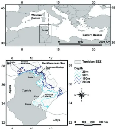
Tunisia is located in the southern Mediterranean, in the transition zone between the eastern and western ba-sins (Fig. 1). Its coastline measures more than 1670 km in length and it is characterized by a variety of habitats. In the north, the seafloor is alternatively rocky and soft, with a narrow continental shelf, a steep slope and impor-tant biodiversity. The eastern region is less rocky and the continental shelf is wider. It features a number of similar species to the northern region, but with less biodiversity (Ben Mustapha & Afli, 2007). The southern region fea-tures the second widest section of continental shelf in the Mediterranean Sea and encompasses the Gulf of Gabes, one of the most productive ecosystems in the Mediterra-nean Sea, of great economic and ecological importance. The Gulf of Gabes supports extensive Posidonia
ocean-ica meadows and high levels of fisheries (Hattab et al.,
2013). A review revealed that the northern region hosts 867 species, the eastern region hosts 292 species, and the southern region hosts 667 species (Afli, 2005),
includ-ing all taxa. The study area encompasses 101,809 km2,
ranging from the coastline until the limit of the Tunisian Exclusive Economic Zone (EEZ) (Fig. 1).
Human threats: mapping and calculating cumulative impacts
In this study, we relied on the extensive experience of multiple experts to gain an understanding of nine human activities currently impacting Tunisia’s marine biodiver-sity. These threats are artisanal fishing, industrial fishing, aquaculture, pollution, the extraction of hydrocarbons, shipping, invasive species, climate change, and habitat degradation.
Some fish species may be not directly affected by certain threats. But given that predator-prey interactions are governing communities structure and that composi-tion of fish communities has great bearing on lower or higher trophic levels through top-down and bottom-up processes (Zambrano et al., 2006), the whole fish diver-sity may be directly or indirectly affected by the human threats included in this study.
The following section briefly discusses each threat in more detail.
Fishing activity
The distinction between artisanal and industrial fish-ing is not standardized around the world. The Food and Agriculture Organization (Féral, 2001) identifies boats operating a short distance from shore as artisanal
ves-sels, while their definition of an industrial vessel includes those with onboard processing facilities. Under the Tuni-sian Fisheries Department definitions, the only industrial fishing activity occurring in Tunisia is trawling, despite the fact that onboard processing does not actually oc-cur on the majority of trawlers. The other vessels using a range of gear types (e.g., bottom and mid-water gill-nets, pots, traps, longlines, purse seines and fishing with lights) are considered to be artisanal or coastal. The Tuni-sian coast hosts 43 fishing ports, each of which supports betweensevenand789 boats. Only nine ports support the industrial bottom trawling fleet (note that pelagic trawl-ing does not currently occur in Tunisian waters), with vessel numbers ranging between one and238 boats per port. To estimate the fishing-related impacts associated with each port, we randomly selected a sample of fisher-men in each of the main fishing ports and asked them to estimate their average fishing range.
We sampled 124 bottom trawling boats on the 5 main fishing ports among the 9 ports hosting trawlers. This cor-responds to nearly 41% of the fleet of the chosen ports. For coastal fleet, we sampled 205 fishing boats on the 12 main fishing ports among the 43 ports hosting coastal or artisanal fishing activity. This corresponds to nearly 20% of the fleet of the chosen ports.
Using this information, we then created fishing pres-sure buffers to capture the fishing prespres-sure exerted from each port.
Aquaculture
During the last 25 years, aquaculture has proliferated in Tunisia’s coastal zone and it is becoming an increas-ingly important industry. Once considered an environ-mentally benign practice, fish farming is now viewed as a potential polluter (Pusceddu et al., 2007). Significant research has been undertaken to examine the impacts of aquaculture on the environment, particularly water qual-ity and disturbance effects on benthic communities. It has been shown that the release of organic matter associated with aquaculture activities causes changes in the compo-sition of benthic communities (Karakassis et al., 2000). The extent to which these disturbances extend beyond the farm boundaries appear varied, with reported dis-tances ranging from 10 to 300m for Mediterranean based farms (Karakassis et al., 2000; Klaoudatos et al., 2006; Neofitou et al., 2010). Aquaculture operations are also known to impact the behavior of wild fish as they assem-ble around the cages to take advantage of the discharge of food waste and feces (FAO, 2003).
Fig. 1: Geographical location of the study area in the Mediterranean Sea and the main geographical features of Tunisia’s exclusive
Medit. Mar. Sci., 17/1, 2016, 190-201 193
There are 28 offshore aquaculture farms in Tunisia’s EEZ (in waters <30 m), the majority of which are located on the country’s eastern side. Coordinates for each farm were obtained from the Tunisian Fisheries and Aquacul-ture Department. As there was little country-specific data available on the impacts of these farms, we compiled in-formation from a range of recent Mediterranean based studies (Karakassis et al., 2000; Klaoudatos et al., 2006; Neofitou et al., 2010). Using this information we devel-oped a ranking system to categorize the level of impact, depending on its spatial extent: Impact3 (0 to 50m), Im-pact2 (50 to 150m), Impact1 (150 to 300m) and Impact 0 (>300m). Buffers of differing widths corresponding to the different impact levels were drawn around each farm.
Pollution
Most coastal areas around the world are reported as having incurred some pollution-related damage (Islam & Tanaka, 2004). The production and emission of pollutants are associated with a range of human activities, including the development and construction of infrastructure, agri-culture, industrial development, and urbanization (Islam & Tanaka, 2004). To identify potential sources of pollu-tion in our study site, we obtained a map from the Agence de Protection et d’Aménagement du Littoral (APAL; www.apal.net.tn), which presented all the database in-formation on outfall locations along the Tunisian coast. These outfalls discharge a range of agricultural, indus-trial, and domestic wastes. Since the dispersal of pollut-ants depends on site-specific hydrodynamic conditions, we compiled the results of two previous impact studies carried out by APAL (APAL, 2009, 2015) and used this information to develop a ranking system to categorize the level of impact. As above, buffers of differing widths were drawn around the pollution source according to the following impact levels: Impact3 (0 to 300m), Impact 2 (300 to 2000m), Impact 1 (2000 to 9000m), and Impact 0(>9000m).
Offshore hydrocarbons activities
The offshore extraction of hydrocarbons (e.g., crude oil, liquefied natural gas) is potentially a major hazard for the marine environment. Offshore installations can dis-turb benthic organisms during their placement and func-tioning, and oil discharges can have significant deleteri-ous impacts. The most widespread and dangerdeleteri-ous conse-quence associated with the oil and gas industry, however, is pollution thatcan occur in conjunction with all activi-ties undertaken at every stage of production, from explo-ration to refinement (Kharaka & Dorsey, 2005).
The threat related to offshore hydrocarbons activi-ties affects directly benthic communiactivi-ties. Since there is a strong control exerted by benthic communities on upper trophic levels such as fish (Hattab et al., 2013), one can consequently assume that perturbations on benthic com-munities can easily impact fish diversity.
Ten offshore concessions currently operate in Tuni-sia’s EEZ, each with one or more wells. There are also four coastal oil refineries and a pipeline network, which serves the largest concessions. We collected data on these infrastructures from the online Entreprise Tunisienne des Activités Pétrolières database (www.etap.com.tn). As with the two preceding threats, we developed a rank-ing systembased on the spatial extent of environmental disturbances. The categories defined were Impact3 (0 to 500m from the well(s) and/or refineries), Impact2 (500 to 1000m from the well(s) and/or refineries), Impact1 (inside the concessions; 0 to 100m around the pipelines) and Impact 0 (elsewhere). Buffers of differing widths corresponding to the different impact levels were drawn around each component of hydrocarbon.
Shipping
Shipping is recognized as having adverse impacts on marine habitats and species: these impacts can result from the associated pollution (e.g., related emissions of petroleum hydrocarbons, antifouling, biocides, and lit-ter), noise, the introduction of invasive species, distur-bances to soft sediment bottoms during navigation, and physical damages (e.g., propeller scarring, anchoring, and groundings; Abdulla, 2008). As commercial ship-ping data for Tunisian waters was not available, we used global-scale data collected by Halpern et al. (2008).
Invasive species
At a global scale, invasive species are recognized as a major threat to biodiversity (Davis, 2003). There is now sufficient evidence to show that invasive species can re-duce the abundance of native species, alter disturbance regimes and basic ecosystem processes, impose large economic costs, introduce new pathogens to indigenous populations, and modify the structure and energy flows of food webs (Libralato et al., 2002). Further, species can be driven to extinction by competitive interactions with invasive species (e.g., Olden et al., 2006), predation by invasive species (e.g., Roemer et al., 2002), or simply by demographic stochasticity when large numbers of new individuals enter the community and occupy part of the carrying capacity (Lande, 1993). The Mediterranean Sea has the highest number of exotic species of anywhere in the world (Streftaris et al., 2005), with the Suez Ca-nal and Gibraltar Strait acting as two key pathways for their introduction. Along the Tunisian coast, 20 Lessep-sian fish species and 14 fish species of Atlantic origin have been identified (CIESM, 2015). Using information sourced from the atlas and grey literature of the Com-mission Internationale pour l’Exploration Scientifique de la Méditerranée (CIESM), we created a database of the geographical ranges of all known exotic fish species along the Tunisian coast. This information was then used to map species richness values in a Geographical Infor-mation System (GIS).
Climate change
There is now considerable evidence to illustrate the ecological impacts of climate change on marine ecosys-tems (e.g., Jones et al., 2013; Woodworth-Jefcoats et al., 2013; Engelhard et al., 2014). Like the rest of the world, the Mediterranean Sea is becoming warmer. For the last 30 to 40 years, sea temperatures have been rising at the surface and at depth (Rivetti et al., 2014). According to the regional climate model NEMOMED8, sea surface temperatures (SST) in the Mediterranean Sea are expect-ed to keep warming, with an estimatexpect-ed increase of 2.8°C
forecasted by the end of the 21stcentury (Beuvier et al.,
2010). Along the Tunisian coasts and according to NE-MOMED8 model, temperatures are projected to increase by 2.4° to 2.8°C by 2080-2099.
In this study, we calculated the average rate of change in SST values during the hottest month of the year (i.e., September; 1982-2012) as a proxy measure of current climate change. To perform this calculation, we used data derived from the multisatellite Pathfinder V5.2 Ad-vanced Very High Resolution Radiometer (AVHRR) SST dataset processed to a resolution of approximately 4.6 km at the equator (http://data.nodc.noaa.gov/pathfinder/ Version5.2/). These data have the highest resolution and cover the longest time period of any satellite-based ocean temperature dataset (Casey et al., 2010). All the day and night Pathfinder SST daily fields were loaded into an R environment to calculate monthly mean maps for each September in the considered time period. The long-term monthly mean SST fields were then used to calculate the slope of SST in each grid cell using linear regression.
Habitat degradation
Habitat degradation is one of the major drivers of global environmental change, responsible for local ex-tinctions and declining ecosystem services (Wilson et al., 2008). In the Mediterranean Sea, studies have demon-strated that habitat degradation is the second most impor-tant human impact, the first being overexploitation (e.g., Coll et al., 2010). In Tunisian waters, critical habitats include the Posidonia seagrass meadows, the corallig-enous assemblages, and the vermetid reefs built by
Den-dropoma petraeum (Ben Mustapha & Afli, 2007). As the
results of existing habitat assessment studies are patchy, we used expert knowledge to rank levels of habitat deg-radation using a 0 to 3 scale.
The impact zones of each of the nine threats were sum-marized at a 0.1° grid resolution (a total of 1986 cells). The human impacts were mapped using GIS (QGIS 2.6.1). Fol-lowing Halpern et al. (2008), we then assigned a weight-ing score to each threat layer: a similar approach was also used by Coll et al. (2012) and Micheli et al. (2013). A group of external experts (and this study’s co-authors) were then asked, using a questionnaire, to rank each threat from 0 to 5, according to their expert knowledge and taking into ac-count the relative importance of each threat to biodiversity.
We relied on the knowledge experience of 14 experts. Two of them come from Mediterranean countries and 12 are Tu-nisians experts. Among these latter, 6 belong to research institutes and 6 to universities. Five of them have proven consulting experience on environmental impact studies with ministries.
We then log[X+1] transformed these values and res-caled them between 0 and 1 to enable direct comparisons.
Finally, we calculated a threat index (Ti) for each grid cell
following:
where i is the layer number, n is the total number of
lay-ers (nine), wi is the weight of layer i, andvi is the threat
value for layer i.
Biodiversity components mapping
Species data and species richness
For the study site, we extracted presence-absence data for 438 fish species from the FishMed database (Albouy
et al., 2015): this database compiles geographical
distribu-tion informadistribu-tion for fish species published in the Fishes of the Northern Atlantic and Mediterranean (FNAM) atlas (Whitehead et al., 1986). Currently, this atlas provides the only available basin-wide occurrence information for all Mediterranean fish species. The occurrence maps generat-ed for each species were refingenerat-ed by removing areas whose depths fell outside their known depth range (see Albouy et
al. (2015) for more details about the database). Thus, our
final dataset summarized the occurrence of 438 fish spe-cies within the Tunisian EEZ at a 0.1° grid resolution. The species richness of each cell was obtained by summing each row in the presence-absence matrix.
Phylogenetic and functional diversity of fish assemblages
In this study, we used a phylogeny that included 62% of Mediterranean teleost fish species and nine outgroups (to build a dated phylogeny). This phylogeny was built from a DNA super matrix composed of four mitochon-drial genes (12S ribosomal DNA, 16S ribosomal DNA, cytochrome c oxidase subunit I, and cytochrome) and two nuclear genes (rhodopsin and recombination activat-ing gene I). This phylogenetic tree does not include all 438species present in our species dataset. Accordingly, the phylogenetic tree was pruned and 341 species were extracted (Meynard et al., 2012). For each fish assem-blage, we computed its phylogenetic diversity using the PD index (Faith, 1992). The PD index relies on the amount of evolutionary history (based on branch length in a phylogenetic tree) represented by a set of species. To calculate functional diversity, we used the FishMed database to compile information on 10 traits for each of the 341fish species (present in the phylogentic tree): maximum length, vertical distribution range, preferred
Medit. Mar. Sci., 17/1, 2016, 190-201 195
habitat types (e.g., rocky, soft bottom, or Posidonia sea-grass meadows), the timing of migration and reproduc-tion events, whether semelparity and/or sex shifts oc-cur, larvae type, behaviour (e.g., gregarious vs. solitary or both), and diet (fishbase.org; Froese & Pauly, 2014). We quantified FD by computing the functional richness index (FRic; Villéger et al., 2008) based on Gower’s method, which calculates the distance between each pair of species. This approach allows for variables of differ-ent natures to be mixed while giving them equal weight (Legendre & Legendre, 1998). We then performed a Principal Coordinates Analysis (PCoA) on Gower’s dis-tance matrix to identify the position of each species in the multidimensional functional space (see Buisson et al., 2013). We kept the first four principal axes of the PCoA to build a multidimensional functional space (Mouillot
et al., 2013). The FRic index represents the volume of
the functional space occupied by a given community. We calculated a biodiversity index (Bi) for each grid cell by summing the three biodiversity layers (i.e., species rich-ness, functional richrich-ness, and phylogenetic richness), log[X+1] transforming the values and then rescaling them between 0 and1.This biodiversity index (Bi) lead to the drawing of a cumulative biodiversity map.
Overlap between the cumulative impacts of human activities and the biodiversity components
For each grid cell, the spatial congruence between the three biodiversity components and the cumulative impacts of the nine human activities were assessed using
an overlap index (Oi) for each cell, calculated as:
Oi = Bi × Ti
Results
Biodiversity component patterns
Species richness values exhibited both an inshore-offshore and latitudinal (south to north) gradient (Fig.
2a). Species richness was higher along the northern coast than the southern coast. Moreover, the coastal areas sup-ported more fish species than the offshore areas, with the exception of the waters around the Kerkenah Islands, which featured the lowest species richness values in the broader Gulf of Gabes. Along the northern coast, some offshore areas also exhibited high species richness (e g., La Galite Island and Serquis Sandbank). Areas of lower species richness (i.e., <100 fish species per cell) were ob-served at the margins of the EEZ while hotspot areas, with up to 300 fish species per cell, appeared along the northern coast. PD and FD exhibited almost the same pattern (Fig. 2b and 2c). As with species richness, low PD or FD areas were located at the EEZ margins, while high diversity areas were encountered along the northern coast. In general, hotspots of all three biodiversity com-ponents matched well spatially. Finally, the cumulative biodiversity map also displayed a similar pattern (Fig. 3).
Threat patterns
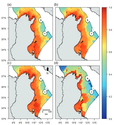
Trawl fishing was most intense at depths of 50m or more, with up to 240 vessels operating in some grid cells. In the northern region, fishing intensity covered a greater area but was less important in terms of overall effort (Fig. 4a). Coastal fisheries activities were most intense in the coastal areas of the Gulf of Gabes (Fig. 4b) where the number of boats per cell reached a maximum of 5480. Aquaculture-associated pressures were restricted to the areas immediately surrounding the offshore farms and only affected 2% of the total study area (Fig. 4c). Pollu-tion impacts were exclusively coastal (~20% of the total study area) and no associated impacts were identified be-yond 15km offshore (Fig.4d). Offshore hydrocarbon ex-traction activities were limited to areas in the vicinity of the installations and collectively identified as impactin-gapproximately10% of the study area (Fig. 4e). Shipping pressure was most pronounced in the northern areas, with high impact regions representing 10% of the total study
Fig. 2: The biodiversity components in the Tunisian exclusive economic zone [expressed on a log scale (0-1)]: species richness
area (Fig. 4f). Invasive species richness was relatively patchy, but in general, coastal areas were more colonized than offshore areas (Fig. 4g). The maximum number of invasive fish species recorded per cell was16. Climate change impacts were more pronounced in coastal areas and also showed a decreasing trend from south to north. Climate change impacts were found to be highest in the Gulf of Gabes (21% of the total study area; Fig. 4h). Hab-itat degradation was determined to be impacting 21% of the total study area, with most affected regions occurring in the Gulf of Gabes and the Gulf of Tunis (Fig. 4i). As expected, cumulative impacts were highest in coastal ar-eas, with highly impacted regions accounting for 38% of the total study area (Fig. 5).
The experts assigned the highest weighting to trawl-ing and habitat degradation, followed by pollution, cli-mate change, coastal fishing, and invasive species. Activ-ities associated with the offshore extraction of
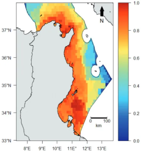
hydrocar-Fig. 3: The cumulative biodiversity components in the Tunisian
exclusive economic zone [expressed on a log scale (0-1)].
Fig. 4: Human threats in the Tunisian exclusive economic zone [expressed on a log scale (0-1)]: (a) Trawling, (b) Coastal fishing,
(c) Aquaculture, (d) Pollution, (e) Offshore hydrocarbons activities, (f) Shipping, (g) Invasive species, (h) Climate change, and (i) Habitat degradation.
Medit. Mar. Sci., 17/1, 2016, 190-201 197
bons were estimated as having one of the lowest impacts, along with shipping and aquaculture (Fig. 6).
Overlap between the cumulative human threat and biodiversity components
Results indicate that there was a very low overlap
(Oi≤25%) between the cumulative threats associated
with human activities and the three biodiversity compo-nents in less than 1% of the study site (Tunisian EEZ). In approximately 15% of the study area, there was a low
overlap (25%≤Oi<50%); in 35% of the area, there was
a medium overlap (50%≤Oi<75%); and in 48% of the
area, there was a high overlap (75%≤Oi<95%). Finally,
there was a very high overlap (Oi≥95%) in 1.5% of the
area: these high overlap areas occurred in the center of the Gulf of Gabes and in the Gulf of Tunis, particularly the Zembra Archipelago MPA (Fig. 7a). When the over-lap with each biodiversity component was considered separately, the overlap patterns for both species richness
and PD appeared very similar (Fig. 7b and 7c), while the overlap with FD was spatially less extensive. However, with FD areas of very high overlap were more prevalent (4.6% of the total area; Fig. 7c).
Discussion
A key component for conservation planning and management is understanding the intersect between bio-diversity and human activities: by mapping these two ele-ments, the degree of overlap (or zone of potential impact) can be easily identified. The results of such an approach could be incorporated within a transparent and repeatable structured decision-making (SDM) process and provide a useful tool for stakeholders (Tulloch et al., 2015).
In this study, we used a semi-quantitative method to assess the cumulative impacts of human activities on three biodiversity components (species richness, phy-logenetic diversity, and functional diversity) at a local scale. To complete this assessment, we compiled datasets for each of the nine human activities considered. We also drew heavily on the collective expertise and experiences of a range of stakeholders. Our study was inspired by the methodological approaches developed in previous glo-bal (Halpern et al., 2008) and regional (Coll et al., 2012; Micheli et al., 2013) studies. Our analysis, however, was focused at the local scale and when assessing impacts, we broadened the scope to consider three distinct biodiver-sity components.
Biodiversity is more than just species richness. Rath-er, it can be viewed from alternative angles, using simple metrics that integrate biological differences between spe-cies that are related, either through evolution or by their functional traits. Such differences have been found to be important drivers of ecosystem functioning (Cadotte
et al., 2008, 2012): for example, evolutionarily diverse
assemblages enhance ecosystem productivity (Cadotte, 2013). In another example, it has been found that main-taining stability in multiple ecosystem processes over long time periods and through multiple environmental change scenarios requires species with complementary functions (Isbell et al., 2011). In cases where these three distinct biodiversity components are not spatially con-gruent, conservation actions that only focus on maintain-ing species richness may not adequately protect either the evolutionary history and/or functional diversity, with sig-nificant repercussions for the long-term viability of the ecosystem (Cadotte et al., 2011). In the Tunisian context, all three components are more or less similarly distrib-uted in space, which means that even if species richness is the sole focus of management efforts, those efforts are likely to preserve all biodiversity components. This could facilitate the implementation of conservation measures.
Despite global-scale data on human activities and their associated impacts becoming increasingly abundant and accessible through the work of organizations and
Fig. 5: Cumulative human threats in the Tunisian exclusive
economic zone [expressed on a log scale (0-1)].
Fig. 6: Average impact weight of human threats. (OHA:
initiatives such as the Sea Around Us Project, the Na-tional Oceanic and Atmospheric Administration, and the European Environmental Agency, at the local scale such information is not always available. In Tunisia, for ex-ample, despite the efforts of authorities to encourage data sharing and transparency, some data remain largely inac-cessible. The results of this study indicate that the highest concentrations of both cumulative threats and biodiver-sity tended to be concentrated in coastal areas: the most highly impacted regions identified were located off the Gulf of Gabes and patches of the Gulf of Tunis. These ar-eas correspond with those found by Micheli et al. (2013) and overall, the general overlap pattern is roughly similar to that found by Coll et al. (2012).
Our results also highlighted areas of ‘high to very high’ overlap around the MPAs in the La Galite and Zem-bra archipelagoes. At ZemZem-bra, an overlap value of close to 1was driven by very high threat and biodiversity indi-ces while La Galite’s overlap value of around 0.76 was due to a very high biodiversity index and a high threat index. Under Tunisian legislation, MPAs are further sup-ported with an additional 1.5 nautical mile no-take zone. This measure seeks to reduce fishing-related pressures in neighboring areas but as our results highlight, it is also important to recognize the cumulative impact of all
hu-man activities. Further, current MPAs only cover a very small proportion of the high overlap areas identified, highlighting the need to extend Tunisia’s MPA network and carefully monitor existing MPAs.
Being complementary with an hotspot approach (Roberts et al., 2003), our analysis taking into account the overlap between cumulative threats and biodiversi-ty, sets the basis for systematic conservation planning. Indeed, while evaluating the degree of overlap between threats and biodiversity in protected areas provides in-sights for their monitoring, further analyses are required to set cost-effective conservation solutions (Margules & Pressey, 2000). Such approaches, coined as systematic conservation planning (SCP), encapsulate the concepts and the tools needed to meet the basic objectives of re-serve systems (representativeness of the different facets of biodiversity to be protected; and long-term persistence of species populations inside a network of protected ar-eas), while minimizing cost and maximizing feasibility by providing flexible conservation solutions (Margules & Pressey, 2000). The data gathered here regarding pro-tected areas location, biodiversity features, human in-duced threats and opportunity cost (fishing), constitute the basic bricks of SCP and provide the starting point for an affective SCP on Tunisian coasts.
Fig. 7: Overlap values between cumulative human impacts and (a) cumulative biodiversity components, (b) species richness, (c)
Medit. Mar. Sci., 17/1, 2016, 190-201 199
Our approach could be modified to take into account other valuable biodiversity metrics such as beta diversity. This may be highly beneficial, as beta diversity has been proven to offer greater accuracy in a conservation plan-ning context than either alpha or gamma diversity (Fer-rier et al., 2007).
Such an approach can also be used to improve our management of human activities, allowing us to target those having the most impact and thus, act to reduce the cumulative threat in biodiversity hotspot areas (Micheli
et al., 2013). According to expert opinion, the three
hu-man activities with the highest impact in Tunisia are bot-tom trawling, habitat degradation, and pollution. These threats could be addressed through a reduction in fishing effort, improved outfall management and adequate habi-tat restoration measures, respectively. Climate change, coastal fishing, and invasive species are the next three highest impacting activities. Coastal fishing could be better managed through fisheries effort adjustments, and while the effects of climate change and invasive spe-cies cannot be removed, their impacts can be lessened through adaptation and mitigation measures (Micheli et
al., 2013). Counter intuitively, offshore hydrocarbon
ex-traction activities are considered to have some of the low-est impacts, despite the significant environmental risks an associated accident may bring. However, the drastic security measures taken to reduce the risk of accidents mean that we can consider their impact relatively low.
Our analyses have some limitations. Firstly, we did not consider the threat of illegal fishing, as data on this activity are scarce in Tunisia and the small amount of data that do exist are confidential. However, we know that trawlers make regular incursions into prohibited depths (DGPA, 2012), and illegal fishing gear types are used, especially a small trawl deployed by small boats in very shallow areas (<10m depth). This non-selective and highly destructive gear type results in the degradation of
Posidonia meadows and the depletion of resource stocks
(CGPM, 2000).
Secondly, due to the approach we used to quantify fishing effort, it is likely that fishing intensity was overes-timated. Identifying the true boundaries of fishing zones is difficult because fishers are reluctant to reveal their fishing strategies. Consequently, instead of using maps of nominal or effective fishing effort deployed in real fishing zones, we used a procedure based on the estima-tion of the mean fishing range of each fleet. This results in potential fishing zones where fishing effort could be overestimated. The best way to overcome this limitation would be to use Vessel Monitoring System data, but this technology is not compulsory in Tunisia and to date, very few trawlers have allowed a system to be installed.
Thirdly, all fish species were affected by the same values of threat even if they are nor equally impacted by this threat (for example a goby is not as impacted by fish-ing as a swordfish and a swordfish is not as impacted by
coastal pollution as a goby). One solution would be to weight each species by its sensitivity to a given threat.
Fourthly, the buffers representing the spatial extent of environmental disturbances around aquaculture farms and pollution outfalls were based on information com-piled from a range of studies, each of which reported different results. Since the true spatial extent of environ-mental disturbance around each feature depends on the specific hydrodynamic and climate conditions found in each area, these homogenized impact scores that we as-signed to each buffer category may be biased. Neverthe-less, given the absence of studies investigating the each disturbance source, such a bias was unavoidable.
Finally, our threat index is based on weighting scores that were assigned for each threat layer. These weights were developed on contributions from experts with an extensive knowledge of Tunisia. The type of uncertain-ties related to such an approach have already been dis-cussed in previous studies (e.g., Halpern et al., 2008; Teck et al., 2010; Ramirez-Llodra et al., 2011; Micheli et
al., 2013). Although quite subjective, this approach has
nonetheless been proven to be robust and in this context, constitutes the best method at this scale for quantifying human impacts. Moreover, since we only used the opin-ions of those with country-specific expertise, it is valid to assume the outcome is semi-quantitative and realistic.
Despite these limitations, however, our study marks the first attempt to assess the overlap between human impacts and three different fish biodiversity components at a local scale. Our results revealed that such a simple spatial approach can be useful in environmental decision-making and for identifying conservation priorities when combined with systematic planning approaches. Access to improved data (i.e., type, quality, and quantity) would no doubt serve to enhance this analysis; however, in the interim, it establishes a useful foundation for improved conservation planning and should offer policy makers interesting opportunities. We recommend that future ef-forts should focus on exploring biodiversity changes un-der different climate change, invasive species, and man-agement scenarios, undertaking sensitivity analysis to explore the effects of weights on final cumulative threats, and broadening the analysis to include all taxa.
Acknowledgement
This work was funded by the Institut de Recherche pour le Développement (JEAI GAMBAS project).
References
Abdulla, A., 2008. Maritime traffic effects on biodiversity in
the Mediterranean Sea: review of impacts, priority areas and mitigation measures. IUCN Centre for Mediterranean
Afli, A., 2005. La biodiversité marine en Tunisie. Rapport du Ministère de l’Environnement et du Développement Du-rable, 20 pp.
Albouy, C., Ben Rais Lasram, F., Velez, L., Guilhaumon, F., Meynard, C.M. et al., 2015. FishMed: traits, phylogeny, current and projected species distribution of Mediterra-nean fishes and environmental data. Ecology (under press). APAL, 2009. Etude de la frange littorale de Monastir, stratégie
de réhabilitation. Rapport du Ministère de l’Environnement
et du Développement Durable, 61 pp.
APAL, 2015. Etude de la frange littorale de la baie de
Monas-tir. Rapport du Ministère de l’Environnement et du
Dével-oppement Durable, 93 pp.
Barnosky, A.D., Matzke, N., Tomiya, S., Wogan, G.O., Swartz, B. et al., 2011. Has the Earth/’s sixth mass extinction al-ready arrived? Nature, 471, 51-57.
Beaumont, N., Austen, M., Atkins, J., Burdon, D., Degraer, S.
et al., 2007. Identification, definition and quantification of
goods and services provided by marine biodiversity: im-plications for the ecosystem approach. Marine Pollution
Bulletin, 54, 253-265.
Ben Mustapha, K., Afli, A., 2007. Quelques traits de la
bio-diversité marine de Tunisie: Proposition d’aires de con-servation et de gestion. Report of the MedSudMed Expert
Consultation on Marine Protected Areas and Fisheries Management, MedSudMed Technical Documents. Rome (Italy), pp. 32–55.
Beuvier, J., Sevault, F., Herrmann, M., Kontoyiannis, H., Lud-wig, W. et al., 2010. Modeling the Mediterranean Sea in-terannual variability during 1961-2000: Focus on the East-ern Mediterranean Transient. Journal of Geophysical
Re-search: Oceans, 115, C08017, doi:10.1029/2009JC005950.
Buisson, L., Grenouillet, G., Villéger, S., Canal, J., Laffaille, P., 2013. Toward a loss of functional diversity in stream fish assemblages under climate change. Global Change
Biol-ogy, 19, 387-400.
Cadotte, M.W., 2013. Experimental evidence that evolutionarily diverse assemblages result in higher productivity.
Proceed-ing of the National Academy of Science, 110, 8996-9000.
Cadotte, M.W., Cardinale, B.J., Oakley, T.H., 2008. Evolution-ary history and the effect of biodiversity on plant produc-tivity. Proceeding of the National Academy of Science, 105, 17012-17017.
Cadotte, M.W., Carscadden, K., Mirotchnick, N., 2011. Be-yond species: functional diversity and the maintenance of ecological processes and services. Journal of Applied
Ecology, 48, 1079-1087.
Cadotte, M.W., Dinnage, R., Tilman, D., 2012. Phylogenetic diversity promotes ecosystem stability. Ecology, 93, S223-S233.
Cardinale, B.J., Duffy, J.E., Gonzalez, A., Hooper, D.U., Per-rings, C. et al., 2012. Biodiversity loss and its impact on humanity. Nature, 486, 59-67.
Casey, K.S., Cornillon, T.B., Evans, R., 2010. The past, present, and future of the AVHRR Pathfinder SST program. p. 273-287. In: Oceanography from space. Springer, Netherlands. CGPM, 2000. Rapport de la 25ème session de la Commission
Générale des Pêches pour la Méditerranée. ISBN
92-5-20-4513-9, 28 pp.
Chapin, F.S., Zavaleta, E.S., Eviner, V.T., Naylor, R.L., Vi-tousek, P.M. et al., 2000. Consequences of changing biodi-versity. Nature, 405, 234-242.
CIESM, 2015. The CIESM Atlas of exotic species in the
Mediterranean. http://www.ciesm.org (Accessed January
2015).
Coll, M., Piroddi, C., Albouy, C., Ben Rais Lasram, F., Cheung, W.W. et al., 2012. The Mediterranean Sea under siege: spatial overlap between marine biodiversity, cumulative threats and marine reserves. Global Ecology and
Biogeog-raphy, 21, 465-480.
Coll, M., Piroddi, C., Steenbeek, J., Kaschner, K., Lasram, F.B.R. et al., 2010. The biodiversity of the Mediterranean Sea: estimates, patterns, and threats. PloS One, 5, e11842. Davis, M.A., 2003. Biotic globalization: does competition
from introduced species threaten biodiversity? Bioscience, 53, 481-489.
DGPA, 2012. Annuaire des statistiques des pêches en Tunisie
de la Direction Générale la Pêche et de l’Aquaculture.
Ministère de l’Agriculture, 135 pp.
Engelhard, G.H., Righton, D.A., Pinnegar, J.K., 2014. Climate change and fishing: a century of shifting distribution in North Sea cod. Global Change Biology, 20, 2473-2483. Faith, D.P., 1992. Conservation evaluation and phylogenetic
diversity. Biological Conservation, 61, 1-10.
FAO, 2003. Review of the state of world aquaculture. FAO Fisheries Circular, 886, 3 pp.
Féral, F., 2001. Sociétés maritimes, droits et institutions des
pêches en Méditerranée occidentale: revue synthétique des droits collectifs et des systèmes décentralisés de disci-pline professionnelle. FAO Documents Techniques sur les
pêches, No 420, 62 pp.
Ferrier, S., Manion, G., Elith, J., Richardson, K., 2007. Using generalized dissimilarity modelling to analyse and predict patterns of beta diversity in regional biodiversity assess-ment. Diversity and Distributions, 13, 252-264.
Froese, R., Pauly, D., 2014. Fish Base. http://www.fishbase.org (Accessed January 2014).
Halpern, B.S., Walbridge, S., Selkoe, K.A., Kappel, C.V., Micheli, F. et al., 2008. A global map of human impact on marine ecosystems. Science, 319, 948-952.
Hattab, T., Ben Rais Lasram, F., Albouy, C., Romdhane, M.S., Jarboui, O. et al., 2013. An ecosystem model of an exploit-ed southern Mexploit-editerranean shelf region (Gulf of Gabes, Tunisia) and a comparison with other Mediterranean eco-system model properties. Journal of Marine Systems, 128, 159-174.
Isbell, F., Calcagno, V., Hector, A., Connolly, J., Harpole, W.S.
et al., 2011. High plant diversity is needed to maintain
eco-system services. Nature, 477, 199-202.
Islam, M.S., Tanaka, M., 2004. Impacts of pollution on coastal and marine ecosystems including coastal and marine fish-eries and approach for management,: a review and synthe-sis. Marine Pollution Bulletin, 48, 624-649.
Jones, M.C., Dye, S.R., Fernandes, J.A., Frölicher, T.L., Pin-negar, J.K. et al., 2013. Predicting the impact of climate change on threatened species in UK waters. PloS One, 8, e54216.
Karakassis, I., Tsapakis, M., Hatziyanni, E., Papadopoulou, K.-N., Plaiti, W., 2000. Impact of cage farming of fish on the seabed in three Mediterranean coastal areas. ICES Journal
of Marine Science, 57, 1462-1471.
Kharaka, Y.K., Dorsey, N.S., 2005. Environmental issues of petroleum exploration and production: Introduction.
Medit. Mar. Sci., 17/1, 2016, 190-201 201
Klaoudatos, S., Klaoudatos, D., Smith, J., Bogdanos, K., Pa-pageorgiou, E., 2006. Assessment of site specific benthic impact of floating cage farming in the eastern Hios island, Eastern Aegean Sea, Greece. Journal of Experimental
Ma-rine Biology and Ecology, 338, 96-111.
Lande, R., 1993. Risks of population extinction from demo-graphic and environmental stochasticity and random catas-trophes. American Naturalist, 911-927.
Legendre, P., Legendre, L., 1998. Numerical Ecology (second English edition). Elsevier Science BV, Amsterdam, 319 pp. Libralato, S., Pastres, R., Pranovi, F., Raicevich, S., Granzotto,
A. et al., 2002. Comparison between the energy flow net-works of two habitats in the Venice Lagoon. Marine
Ecol-ogy, 23, 228-236.
Margules, C.R., Pressey, R.L., 2000. Systematic conservation planning. Nature, 405, 243–253.
Meynard, C.N., Mouillot, D., Mouquet, N., Douzery, E.J., 2012. A phylogenetic perspective on the evolution of Med-iterranean teleost fishes. PLoS One, 7, e36443.
Micheli, F., Halpern, B.S., Walbridge, S., Ciriaco, S., Ferretti, F. et al., 2013. Cumulative Human Impacts on Mediter-ranean and Black Sea Marine Ecosystems: Assessing Cur-rent Pressures and Opportunities. PLoS One, 8, e79889. Mouillot, D., Graham, N.A., Villéger, S., Mason, N.W.,
Bell-wood, D.R., 2013. A functional approach reveals com-munity responses to disturbances. Trends in Ecololgy and
Evolution, 28, 167–177.
Mouillot, D., Villéger, S., Scherer-Lorenzen, M., Mason, N.W., 2011. Functional structure of biological communities pre-dicts ecosystem multifunctionality. PloS One, 6, e17476. Navarro, J., Coll, M., Cardador, L., Fernández, Á.M., Bellido,
J.M., 2015. The relative roles of the environment, human activities and spatial factors in the spatial distribution of marine biodiversity in the Western Mediterranean Sea.
Progress in Oceanography, 131, 126-137.
Neofitou, N., Vafidis, D., Klaoudatos, S., 2010. Spatial and temporal effects of fish farming on benthic community structure in a semi-enclosed gulf of the Eastern Mediter-ranean. Aquaculture Environment Interaction, 1, 95-105. Norling, K., Rosenberg, R., Hulth, S., Gremare, A., Bonsdorff, E.,
2007. Importance of functional biodiversity and species-spe-cific traits of benthic fauna for ecosystem functions in marine sediment. Marine Ecology Progress Series, 332, 11-23. Olden, J.D., Poff, N.L., Bestgen, K.R., 2006. Life-history
strat-egies predict fish invasions and extirpations in the Colo-rado River Basin. Ecological Monographs, 76, 25-40. Palumbi, S.R., Sandifer, P.A., Allan, J.D., Beck, M.W., Fautin,
D.G. et al., 2008. Managing for ocean biodiversity to sus-tain marine ecosystem services. Frontiers in Ecology and
the Environment, 7, 204–211.
Pusceddu, A., Fraschetti, S., Mirto, S., Holmer, M., Danovaro, R., 2007. Effects of intensive mariculture on sediment bio-chemistry. Ecological Applications, 17, 1366-1378.
Ramirez-Llodra, E., Tyler, P.A., Baker, M.C., Bergstad, O.A., Clark, M.R. et al., 2011. Man and the last great wilderness: human impact on the deep sea. PLoS One, 6, e22588. Rivetti, I., Fraschetti, S., Lionello, P., Zambianchi, E., Boero,
F. 2014. Global warming and mass mortalities of ben-thic invertebrates in the Mediterranean Sea. PloS one, 9, e115655.
Roberts, C.M., Branch, G., Bustamante, R.H., Castilla, J.C., Dugan, J. et al., 2003. Application of ecological criteria in selecting marine reserves and developing reserve net-works. Ecological Applications, 13, 215-228.
Roemer, G.W., Donlan, C.J., Courchamp, F., 2002. Golden ea-gles, feral pigs, and insular carnivores: how exotic species turn native predators into prey. Proceeding of the National
Academy of Science, 99, 791-796.
Sponsel, L.E., 2001. Human impact on biodiversity, overview.
Encyclopedia Biodiversity, 3, 395-409.
Streftaris, N., Zenetos, A., Papathanassiou, E., 2005. Globali-sation in marine ecosystems: the story of non-indigenous marine species across European seas. Oceanography and
Marine Biology - an Annual Review, 43, 419–453.
Teck, S.J., Halpern, B.S., Kappel, C.V., Micheli, F., Selkoe, K.A. et al., 2010. Using expert judgment to estimate ma-rine ecosystem vulnerability in the California Current.
Ecological Applications, 20, 1402-1416.
Tulloch, V.J., Tulloch, A.I., Visconti, P., Halpern, B.S., Watson, J.E. et al., 2015. Why do we map threats? Linking threat mapping with actions to make better conservation deci-sions. Frontiers in Ecology and the Environment, 13, 91-99.
Villéger, S., Mason, N.W., Mouillot, D., 2008. New multidi-mensional functional diversity indices for a multifaceted framework in functional ecology. Ecology, 89, 2290-2301. Wagler, R., 2011. The anthropocene mass extinction: An
emerging curriculum theme for science educators. The
American Biology Teacher, 73, 78-83.
Whitehead, P., Bauchot, L., Hureau, J., Nielsen, J., Tortonese, E., 1986. Fishes of the north-eastern Atlantic and the
Med-iterranean. UNESCO, Paris.
Wilson, S., Fisher, R., Pratchett, M., Graham, N., Dulvy, N. et
al., 2008. Exploitation and habitat degradation as agents of
change within coral reef fish communities. Global Change
Biology, 14, 2796-2809.
Woodworth-Jefcoats, P.A., Polovina, J.J., Dunne, J.P., Blan-chard, J.L., 2013. Ecosystem size structure response to 21st century climate projection: large fish abundance de-creases in the central North Pacific and inde-creases in the California Current. Global Change Biology, 19, 724–733. Zambrano, L., Perrow, M.R., Sayer, C.D., Tomlinson, M.L.,
Davidson, T.A., 2006. Relationships between fish feeding guild and trophic structure in English low land shallow lakes subject to anthropogenic influence: implications for lake restoration. Aquatic Ecology, 40, 391-405.
![Fig. 2: The biodiversity components in the Tunisian exclusive economic zone [expressed on a log scale (0-1)]: species richness (a), phylogenetic diversity (b), and functional diversity (c).](https://thumb-eu.123doks.com/thumbv2/123doknet/13701268.433421/9.892.177.732.820.1062/biodiversity-components-tunisian-exclusive-expressed-phylogenetic-diversity-functional.webp)
![Fig. 4: Human threats in the Tunisian exclusive economic zone [expressed on a log scale (0-1)]: (a) Trawling, (b) Coastal fishing, (c) Aquaculture, (d) Pollution, (e) Offshore hydrocarbons activities, (f) Shipping, (g) Invasive species, (h) Climate change](https://thumb-eu.123doks.com/thumbv2/123doknet/13701268.433421/10.892.158.408.200.458/tunisian-exclusive-expressed-trawling-aquaculture-pollution-hydrocarbons-activities.webp)