HAL Id: hal-02822962
https://hal.inrae.fr/hal-02822962
Submitted on 6 Jun 2020HAL is a multi-disciplinary open access archive for the deposit and dissemination of sci-entific research documents, whether they are pub-lished or not. The documents may come from teaching and research institutions in France or abroad, or from public or private research centers.
L’archive ouverte pluridisciplinaire HAL, est destinée au dépôt et à la diffusion de documents scientifiques de niveau recherche, publiés ou non, émanant des établissements d’enseignement et de recherche français ou étrangers, des laboratoires publics ou privés.
Dominique King, Yves Le Bissonnais, Olivier Cerdan, Christine King, Guy
Richard, Véronique Souchère
To cite this version:
Dominique King, Yves Le Bissonnais, Olivier Cerdan, Christine King, Guy Richard, et al.. Origin and specificity of the STREAM model. 5. European Congress on Regional Geoscientific Cartography and Information Systems, Jun 2006, Barcelone, Spain. 6 p. �hal-02822962�
Session 9 – Oral or poster presentation 1
ORIGIN AND SPECIFICITY OF THE STREAM MODEL
(Sealing and Transfer by Runoff and Erosion related to Agricultural Management
)Dominique King
(1), Yves Le Bissonnais
(2), Olivier Cerdan
(3), Christine King
(3), Guy Richard
(1),
VeroniqueSouchère
(4)(1) Institut National de la Recherche Agronomique, Unité de Science du Sol, Centre de Recherche d’Orléans, BP20619, 45166 Olivet, France [email protected].
(2) Institut National de la Recherche Agronomique, Unité de Science du Sol, LISAH, Centre de Recherche de Montpellier, Campus AGRO, Bat. 24 - 2 place Viala - 34060 Montpellier Cedex 1 - France
(3) brgm, Service Aménagement et Risques Naturels, 3 av.Claude Guillemin, BP6009, 45060 Orléans Cedex, France [email protected], o.cerdan @brgm.fr
(4) Institut National de la Recherche Agronomique, Systèmes Agraires et Développement Ile de France, Centre de Recherche de Versailles, 78026 Versailles Cedex, France
KEY WORDS: soil erosion, soil surface characteristics, modelling, remote sensing, optic satellite data, SAR data, GIS.
INTRODUCTION
The European Commission recognised when they launched their thematic strategy for soil protection in 2002 (CEC 2002) that erosion was the primary threat to soil resources. This phenomenon has long been well known and has been the object of much scientific research (De Ploey, 1989 ; Oldeman et al., 1991). Current studies focus on how to quantify the impact of anthropogenic and climate changes that might cause an increase in soil loss and to develop tools to evaluate soil protection measures (landscaping, spatial distribution of cropping systems, technical itinerary). Numerical modelling of runoff and erosion is an excellent means of responding to these challenges.
We encounter numerous problems when attempting to model erosion: the complexity of the processes involved (rainsplash, sheetwash, rilling and gullying, deposition, etc.) and their occurrence at vastly different scales (from aggregates to entire drainage basins), the wide range of determining factors and their spatial variability (soil properties, rainfall intensity, tillage practices, etc (Papy & Boiffin,1989). Furthermore, farming practices are multifactorial and depend not only on soil-climate conditions, but also on economic, social and even political components (Boardman, 1990 ; Auzet et al., 1993 ; Souchere et al., 2002).
One of the oldest erosion equations, and certainly the most widely-used, is the USLE, or Universal Soil Loss Equation (Wischmeier & Smith, 1978). It is a conceptual model expressed
as a combination of causes. It has been refined over the years and has been adapted to conditions in different parts of the world ( i.e Williams et al., 1983). The advent of numerical methods during the 1980s led to the development of mechanistic models based on physical principles and enabled researchers to take into account more efficiently the processes involved and their interactions (Beven & Kirkby, 1979). These models proliferated in the 80s and were the object of numerous publications in subsequent years (Knisek, 1980 ; Morgan et al., 1982 ; Woolhiser et al., 1990 ; Laflen et al., 1991 ; De Roo et al., 1996).
The STREAM model (Sealing and Transfer by Runoff and Erosion related to Agricultural Management) was created in the end of 1990s following a critical analysis of various modelling approaches (Cerdan et al., 2001) (fig.1). USLE-based models could not account for the erosion observed in Northern Europe—relatively flat topography, oceanic climate, loamy soil (Fullen & Reed, 1987; De Ploey, 1989 ; Auzet et al., 1990). Mechanistic models are poorly suited due to the large number of parameters involved, many of which are often unavailable at such a vast scale (De Roo, 1993). The decision to develop a new model within the framework of an international concerted action was born of the conjunction of three phenomena: 1) the demonstration of the importance of surface degradation of soil structure as a determining factor in soil erosion, 2) the development of digital technology (GIS— Geographic Information Systems) enabling both the description of a model's fluxes and the quantitative spatialization of input variables (King et al., 1998), and 3) the availability of new remote sensing data in the operational phase for gathering
images over large surface areas. These three points are discuss briefly here.
(1) SURFACE DEGRADATION OF SOIL STRUCTURE
Most soil erosion models describe hydrological processes and soil particle removal and transport processes. The equations are based mainly on the laws of water transfer in soil and on the surface. The velocity of surface runoff determines the quantity of particles removed and transported in relation to the soil's structural properties (Govers, 1985). These are described in the models mainly by their geometry (roughness, which enables retention of rain) and by soil water content (which limits infiltration) (Engman, 1986). The surface mechanisms studied are mainly those linked to the splash effect (Bradford et al.,1987) and to the particle movement implied by this mechanism and the slope (Quinn et al., 1995; Salles et al., 2000).
The soil surface characteristics, however, are not sufficiently taken into account in these models. Indeed, French studies in the 1980s clearly demonstrated the determining role of crusting on the decrease in infiltration and the formation of runoff (Valentin & Bresson, 1992; Le Bissonnais et Singer, 1992). They also showed
that these soil surface characteristics were themselves determined by interaction between the nature of soils and the action of rainfall. Conditions preceding the rainfall events that triggered runoff were studied — in particular, the farming practices that produced the structural state of the soil (degree of fragmentation during tillage, degree of compaction by farm machinery) (Govers et al., 1994 ; Souchere et al., 1998; Martin, 1999 ; Richard et al., 2001) and the weather on days prior to the rainfall event (Le Bissonnais & Singer, 1992; Kirkby & Cox, 1995).
This first analysis showed that changes in the surface state appeared to be a key element and should be incorporated into the models. This data could be entered directly as one of the model's input parameters, thus simplifying parameterization (Le Bissonnais et al, 1998). It seemed that the surface state was a variable that would be easier to acquire directly than calculate using a model combining characteristics that are themselves difficult to measure, that is to say, the quantity and intensity of rainfall, the structural stability of soils and farming practices.
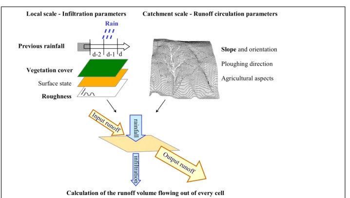
Figure 1 – Input data for the STREAM model: the parameters in bold are retained in the version of STREAM assimilating remote sensing data ( STREAM-TED).
ra in fa ll in fil trat io n
Local scale - Infiltration parameters
Vegetation cover Rain d d-2 d-1 Surface state Roughness
Previous rainfall Slope and orientation
Ploughing direction Catchment scale - Runoff circulation parameters
Agricultural aspects
Calculation of the runoff volume flowing out of every cell Inpu
t runoff
Outp ut ru
Session 9 – Oral or poster presentation 3
(2) DEVELOPMENT OF DIGITAL
SPATIALIZATION TECHNIQUES
Geographic Information Systems (GIS) unite all of the methods that enable digital acquisition, spatialization, management and restitution of geographic data (Burrough, 1986), and have progressively replaced manual mapping. Up until the early 1980s, map information was mostly qualitative. The appearance of GIS and geographic databases opened up new possibilities for cross-referencing spatialized data. The appearance of the first Digital Elevation Models (DEM) enabled researchers to calculate slope gradients and orientations and generate theoretical runoff models from which numerous hydrological characteristics in the field could be deduced (Beven et al, 1984). The first studies involved combining the various factors causing soil erosion and mapping erosion risk (King & Le Bissonnais, 1992) and were essentially a formalization of experience gained in the field (Le Bissonnais & Singer, 1993; Le Bissonnais et al, 1998). Very rapidly, however, we were faced with the question of including models of water and matter transport in soil using methods developed for GIS ( De Roo, 1998 ; Cerdan et al. , 2002 ; Souchere et al., 2003).
A description of fluxes entailed a spatialized description of the parameters, other than slope, that control these fluxes. At this stage, we noticed that the more parameters a model had, the more trouble it had dealing with their variability. It was therefore necessary to identify and rank the parameters involved in the runoff and erosion processes in an attempt to arrive at relatively stable results. It is of interest to note that while DEM have enabled us to rapidly generate quantitative and detailed images of slopes, they have obscured the fact that the direction of runoff also depends on other factors such as surface roughness (Engman, 1986; Govers et al., 2000) or manmade structures (ditches, dead furrows, etc.) (Souchere et al., 1998).
This second analysis showed the importance when choosing model parameters not only of the role that they play in reality but also the accessibility and precision over a large spatial field of the parameter data. This naturally led us to consider parameter data acquisition and spatialization methods.
(3) ACQUISITION OF NEW SPATIALIZED DATA BY REMOTE SENSING
Satellite techniques provide a easy means of obtaining precise and thorough information.
Since the late 1970s, remote sensing has furnished images enabling us to acquire data on land use (Cihlar et al., 1987; Bocco & Valenzuela, 1991). This opened up the possibility of including in numerous models the role of vegetation in protecting soil from degradation and erosion (by reducing the energy of raindrops, retaining water, slowing runoff, etc.) (Keech, 1990). Remote sensing techniques seemed to provide more limited results, however, when it came to directly determining soil characteristics (Huete 1989, Hill et al., 1992 ; Arrouays et al. , 1996 ; Mathieu et al., 1996). Not only did the presence of vegetation rarely enable researchers to access bare soil, but also, the wavelengths, most often in the visible and near infrared range at that time, furnished only information on the spectral response of the soil surface (De Jong & Riezeboss, 1994; Jacob et al., 2002). These techniques therefore seemed to be poorly suited to estimating the spatial variability of soils and even less to mapping their hydrodynamic properties, if we except the 2D contribution of images for extracting as interpretative or automated methods the ways of water (linear incisions, rills, furrows, natural or artificial drains, slope..) (Blanchard et al., 1999).
As we have seen in the two previous analyses, however, soil surface properties are the key parameters for infiltration and therefore runoff (Govers et al., 2000). The remote sensing data therefore needed to be re-examined from another angle. In addition, new techniques were being developed with the launching of radar satellites (Autret et al., 1989 ; Beaudoin et al. 1990). These, thanks notably to sensitivity to dielectric properties, delivered two essential elements of information concerning erosion phenomena: soil moisture and roughness (Remond et al., 1999 ; Baghdadi et al., 2002 ). Those information can be successfully assimilated by STREAM (King et al., 2005b).
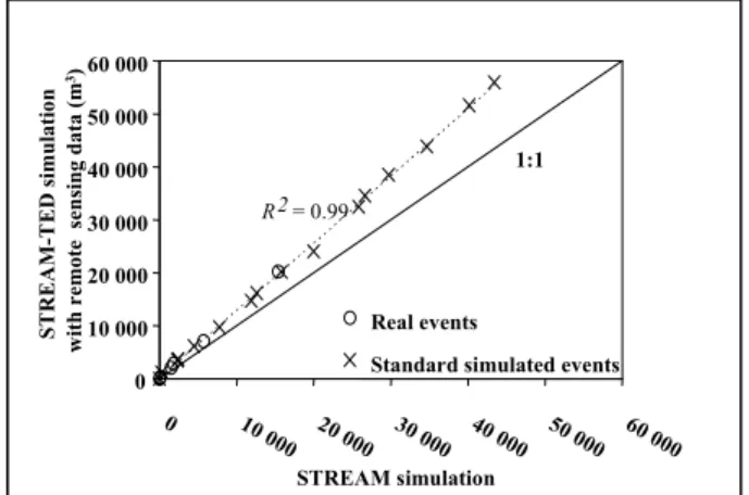
Figure 2 – Prediction of the runoff at the outlet by STREAM-TED as a function of the STREAM simulation. R2 = 0.99 0 10 000 20 000 30 000 40 000 50 000 60 000 0 10 0 00 20 000 30 000 40 000 50 000 60 000 STREAM simulation STREAM-T ED simulatio n w ith re mote s ens ing data ( m 3) Real events
Standard simulated events 1:1
This third analysis, together with the two previous analyses, offered direct acquisition and spatialization tools for parameters describing soil surface states and roughness. The convergence of these three analyses therefore led us to emphasize the determinant role of these parameters in the development of the STREAM model. The processes of formation and evolution of surface states and roughness are poorly understood and are themselves very responsive to the random character of interactions between various soil types and both climate conditions and human activities (farming practices). It was therefore preferable to input soil surface characteristics and roughness directly as control parameters in the STREAM model rather than attempt to reconstruct their evolution using a model that is uncertain and overloaded with variables that are hard to spatialize ( fig.2) (King et al., 2005a; 2005b).
CONCLUSION
The driving force behind the creation of the STREAM model was therefore the concurrence of 1) the introduction of recently acquired knowledge (i.e. the role of soil surface states and roughness on infiltration and the direction of fluxes, respectively) and 2) the contribution of new digital data acquisition and processing technologies (i.e. DEM, remote sensing, GIS). Our aim is to develop an operational system in interaction with the actors in areas affected by erosion soil. We have therefore favoured, in addition to remote sensing and based on the work of the French school, qualitative parameters easily accessible in the field and calibrated using experimental approaches under controlled conditions These experimental approaches were necessary in order to verify our hypotheses and precisely calibrate the model.
COLLABORATION
This article was made possible due to the support of the BRGM Research Programme (01METR05), the FLOODGEN European programme (CEE-CEO ENV4CT 96 0368), and the french programme ANR-ECCO- PNRH (RIDES). Specific thanks to Joël Daroussin and Alain Couturier (INRA) for help in using the Kaleidos software (INRA’s internal software and Normandy's Regional Association for the Study and Improvement of Soil (AREAS).
REFERENCES
Arrouays, D.; King, C. ; Vion, I. ; Le Bissonnais, Y. 1996. Detection of soil crusting risks related to low soil organic carbon content by using discriminant
analysis on the Thematic Mapper data. Geocarto International, 11 (4) : 11-16.
Autret, M.; Bernard, M.; Vidal-Madjar, D. 1989. Theoretical study of the sensitivity of the microwave backscattering coefficient to the soil surface parameter. Int. Jour. of Remote Sensing, 10 (1): 171-179.
Auzet, A.V.; Boiffin, J.; Papy, F.; Ludwig, B.; Maucorps, J. 1993. Rill erosion as a function of the characteristics of cultivated catchments in the north of France. Catena 20: 41 -62.
Auzet, A.V.; Boiffin, J.; Papy, F.; Maucorps, J; Ouvry, J.F. 1990. An approach to the assessment of erosion forms and erosion risk on agricultural land in northern Paris basin, France. In: J. Boardman, D.L. Foster and J.A. Dearing (Editors), Soil Erosion on Agricultural Land. Wiley, Chichester, pp. 383-400.
Baghdadi,N.; King,C.; Chanzy, A.; Wigneron, J.P.2002. An empirical calibration of IEM model based on SAR data and measurements of soil moisture and surface roughness over bare soils., Int. Jour. of Rem. Sensing, 23 (20): 4325-4340
Beasley, D.B.; Huggins, L.F.; Monke, E.J 1980 . ANSWERS : a model for watershed planning. Trans of the ASAE.
Beaudoin, A. ; Le Toan, T. ; Gwyn, Q.H.J. 1990. SAR Observations and modelling of the C-Band backscatter variability due to multiscale geometry and soil moisture. IEEE Trans. on Geoscience and Remote Sensing, 28(5): 86-895.
Beven, K.J.; Kirkby, M.J. 1979. A physically based, variable contributing area model of basin hydrology – Hydrological Sci. Bull. 24 (1): 43-69. Beven, K.J.; Kirkby, M.J.; Schoffield, N.; Tagg A. 1984.
Testing a physically based flood forecasting model TOPMODEL fir 3 UK Catchments . J. Hydrology 69: 119-143.
Blanchard, E. ; King, C. ; Le Bissonnais, Y. ; Bourguignon, A. ; Desprats, J.F. ; Maurizot, P. ; Souchere, V. 1999. Paramétrisation du potentiel de ruissellement des bassins versants au moyen de la Télédétection et des GIS. Application à des bassins versants du Pays de Caux. Etude et Gestion des Sols 6 (3) : 181-199.
Boardman, J. 1990. Soil erosion on the South Down : a review. In BoardmanJ, Foster D.L., and Dearing J.A. Soil erosion an Agricultural Land. John Wiley & Sons Ltd , 87-105.
Bocco, G. and Valenzuela, C.R., 1991. Integration of GIS and remote sensing in land use and erosion studies.ECSC,EEC,EAEC, 477-490.
Bradford, J.M.; Ferris, J.E.; Remley, P.A. 1987 . Interrill soil erosion processes. Relationship of splash
Session 9 – Oral or poster presentation 5
detachment to soil properties. Soil Science Soci. of America Journal, 51: 1571-1575.
Burrough P.A 1986 – Principles of Geographic Information Systems for Land Resources Assessment. Monographs on soil and resource survey, Oxford Univ. Presse n°12,194 pages. CEC – COM 16-04-2002.179. Final Communication
from the Commission to the Council, the European Parliament, the Economic and Social Committee and the Committee of the Regions: towards a Thematic Strategy for Soil Protection.
Cerdan, O. ; Le Bissonnais, Y. ; Souchère, V. ; Martin, P. ; Lecomte, V. 2002. Sediment concentration in interrill flow: interactions between soil surface conditions, vegetation and rainfall. Earth Surface Processes & Landforms, 27 (2) : 193-205
Cerdan, O. ; Souchère, V. ; Lecomte, V. ; Couturier, A. ; Le Bissonnais, Y. 2001. Incorporating soil surface crusting processes in an expert-based runoff and erosion model STREAM (Sealing and Transfer by Runoff and Erosion related to Agricultural Management), Catena, 46: 189-205.
Cihlar J., 1987. A methodology for mapping and monitoring cropland soil erosion. Cana. Jour. Soil Science 67: 433-444
De Jong S. and Riezeboos H.Th., 1994. Imaging spectroscopy, geostatistics and soil erosion models. In Conserving Soil Resources. European perspectives (eds J.Rickson). Silsoe Coll.- Cranfield Univ.UK, 232-245.
De Ploey, J. 1989. Erosional systems and perspectives for erosion control in odellin loess areas. Soil Technology series 1: 93-102.
De Roo, A.P.J.; Wesseling C.G.; Ritsema, C.J. 1996. LISEM : a single-event physically based hydrological and soil erosion model for drainage basins : I Theory, input and output. Hydrological Processes 10: 1107-1117.
De Roo, A.P.J., 1993. Modelling surface runoff and soil erosion in catchments using Geographical information Systems. Validity and applicability of the “ANSWERS” model in two catchments in the loess area of South Limburg (The Netherlands) and one in Devon (UK). PhD Utrecht University, 295 pp.
De Roo, A.P.J, 1998. Modelling runoff and sediment transport in catchment using GIS. Hydrological Processes 12: 905-922.
Engman, E.T. 1986 . Roughness coefficient for routing surface runoff J.Irrig.Dran. Div .ASCE ,112(1): 39-53.
Fullen, M.A; Reed, A.H. 1987. Rill erosion on arable loamy sands in the west midlands of England, in Bryan R.B (ed) Rill erosion, processes and significance, Catena, suppl, 8:, 85-96.
Govers, G. 1985. Selectivity and transport capacity of thin flows in relation to rill erosion . Catena, 12: 35-49.
Govers, G.; Takken, I.; Helming, K. 2000. Soil roughness and averland flow. Agronomie, 20: 131-146
Govers, G.;Vandaele, K.; Desmet, P.; Poesen, J.; Bunte, K. 1994. The role of tillage in soil redistribution on hillslopes. European Journal of Soil Science, 45, 409-478.
Govers, G., Takken, I. and Helming, K., 2000. Soil roughness and overland flow. Agronomie 20, 131-146.
Hill, J.; Policini, P.; Mehl, W. 1992 - Mapping degraded mediterranean lands with operational remote sensing satellites. Coll.ESSC “ Conserving our soil resource. Silsoe UK.
Huete, A.R. 1989. Soil influences in remotely sensed vegetation-canopy spectra. Theory and applications of optical remote sensing, G. Asrar (dir.), Wiley & Sons, New-York, 107-141.
Jacob, F.; Olioso, A.; Weiss, M.; Baret, F.; Hautecoeur, O 2002- Mapping short-wave albedo of agricultural surfaces using airborne PolDER data. Remote Sensing of Environment, 80: 36-46
Keech, M.A. 1990. Remote sensing applied to ecological degradation.Chemistry and Industry. 296-298.
King, C.; Baghdadi, N.; Lecomte, V. and Cerdan, O., 2005 a. The application of remote-sensing data to monitoring and modelling of soil erosion CATENA 62, Issues 2-3: 79-93 - Surface characterisation for soil erosion forecasting Ed. By A.-V. Auzet, P. van Dijk and M.J.M. Kirkby
King, C.;Lecomte, V. ; Le Bissonnais, Y. ; Baghdadi, N. ; Souchère, V. and Cerdan, O. -2005 b. Remote-sensing data as an alternative input for the ‘STREAM’ runoff model CATENA 62, Issues 2-3: 125-135 – Surface characterisation for soil erosion forecasting . Ed by A.-V. Auzet, P. van Dijk and M.J.M. Kirkby.
King, D.; Fox, D.M.; Daroussin, J.; Le Bissonnais, Y.; Danneels V., 1998 - Upscaling a simple erosion model from small areas to a large region. Nutrient Cycling in Agroecosystems. 50, 143-149.
King, D. and Le Bissonnais, Y. 1992 - Rôle des sols et des pratiques culturales dans l'infiltration et l'écoulement des eaux. Exemple du ruissellement et de l'érosion sur les plateaux limoneux du nord de l'Europe. C. R. Acad. Agric., 6, 91-105
Kirkby, M., and Cox, N.J., 1995. A climatic index for soil erosion potential (CSEP)including seasonal and vegetation factors. Catena, 25: 333 – 352.
Knisel, W.G, 1980. CREAMS: a field –scale models for chemicals, runoff and erosion form agricultural management systems. Rep n°26, USDA.
Laflen, J.M.; Leonard, J.L.;Foster G.R. 1991. WEPP: a new generation of erosion prediction technology, Journal of Soil and Water Conservation. Janv-Fev-: 34-38.
Le Bissonnais, Y. ; Benkhadra, H. ; Chaplot, V. ; Fox, D. ; King, D. ; Daroussin, J. 1998. Crusting, runoff and sheet erosion on silty loamy soils at various scales and upscaling from m² to small catchments. Soil and Tillage Research 46: 69-80.
Le Bissonnais, Y. and Singer, M.J , 1992 Crusting, Runoff and Erosion response to soil water content and successive rainfall. Soil Science Society of American Journal 56, 1898-1903.
Le Bissonnais, Y. and Singer, M.J , 1993. Seal formation, runoff and interrill erosion from 17 Californian soils. Soil Science Society of American Journal 57:224-229.
Martin, P., 1999. Reducing sediment laden agricultural runoff flood risk using intercrop management techniques in northern France. Soil and Tillage Research 52: 233-245.
Mathieu, R. ; King, C. ; Le Bissonnais, Y. 1996. Contribution of multitemporal SPOT data to the mapping of a soil erosion index. Soil Technology 10 : 99-110.
Morgan, R.P.C.;Morgan, D.D.V.; Finney, H.J., 1984. A predictive model for the assessment of soil erosion risk. J.Agric.Eng.Res. 30, 254-253.
Oldeman, L.R.; Hakkeling, R.T.A; Sombroeck, W.G. 1991. World Map of the Status of Human Induced Soil Degradation: an Explanatory Note. ISRIC, Wageningen. UNEP Nairobi. 34 pp.
Papy, F. and Boiffin, J., 1989. The use of farming systems for the control of runoff and erosion ( example for a given country with talweg erosion). Soil Technology, series 1: 29-38.
Quinn, P.F.; Beven K.J.; Lamb R., 1995. The In (a/tan ) index : how to calculate it and how to use it within the TOPMODEL framework. Hydrological processes 9: 161-182.
Remond, A.; Beaudoin, A. ; King, C., 1999. SAR Imagery to estimating roughness parameters then
odelling runoff risk. Int Journal of Remote Sensing 20 (13): 2613-2625.
Richard, G.;Cousin, I.;Sillon, J.F.; Bruand, A.; Guérif, J., 2001. Effect of compaction on soil porosity : consequences on hydraulic properties. European Journal of Soil Science, 52: 49-58.
Salles, C.; Poesen, J.; and Govers, G. 2000. Statistical and physical analysis of soil detachment by raindrop impact: rain erosivity indices and
threshold energy. Water Resources Research 36:2721-2729.
Souchère, V. ;Cerdan, O. ; Ludwig, B. ; Le Bissonnais, Y. ;, Couturier, A. ; Papy, F. 2003. Modelling ephemeral gully erosion in small cultivated catchments. Catena 50: 489-505.
Souchère, V.;King, C.; Dubreuil, N.; Lecomte-Morel, V. ; Le Bissonnais, Y.; Chalat, M. 2002. Grassland and crop trends: role of the European Union Common Agricultural Policy and consequences for runoff and soil erosion. Environmental Science & Policy, 6 (1) : 7-16.
Souchère, V.; King, D.; Daroussin, J.; Papy, F.; Capillon, A. 1998 . Effects of tillage on runoff direction: consequences on runoff contributing area within agricultural catchments. Jour. of Hydrology 206 : 256-267.
Valentin, C. and Bresson, L.M. 1992. Soil crust morphology and forming processes in loamy and sandy soils. Geoderma 55 : 225-245.
Williams, J.R.; Dyke, P.T.; Jones, C.A. 1983. EPIC a model for assessing the effects on erosion on soil productivity. In Developments in Environmental modelling, 5: 553-572.
Wischmeieer, W.H. & Smith D.D. 1978. Predicting rainfall erosion losses, a guide to conservation planning- USDA Agricultural Handbook 537, 58p. Woolhiser, D.A.;, Smith, R.E.; Goodrich, D.C. 1990
KINEROS, a kinematic runoff and erosion model: documentation and User Manual USAD-ARS , ARS77