SLS: Smart Localization Service
Human Mobility Models and Machine Learning Enhancements for
Mobile Phone’s Localization
Doctoral Dissertation submitted to the
Faculty of Informatics of the Università della Svizzera Italiana in partial fulfillment of the requirements for the degree of
Doctor of Philosophy
presented by
Michela Papandrea
under the supervision of
Marc Langheinrich and Silvia Giordano
Dissertation Committee
Andrew T. Campbell Dartmouth College, Hanover (NH), USA
Archan Misra Singapore Management University, Singapore
Mehdi Jazayeri University of Lugano, Switzerland
Laura Pozzi University of Lugano, Lugano, Switzerland
Dissertation accepted on 17 March 2015
Research Advisor Co-Advisor
Marc Langheinrich Silvia Giordano
PhD Program Directors
Igor Pivkin and Stefan Wolf
I certify that except where due acknowledgement has been given, the work presented in this thesis is that of the author alone; the work has not been sub-mitted previously, in whole or in part, to qualify for any other academic award; and the content of the thesis is the result of work which has been carried out since the official commencement date of the approved research program.
Michela Papandrea Lugano, 17 March 2015
To Manuel
Abstract
In recent years we are witnessing a noticeable increment in the usage of new generation smartphones, as well as the growth of mobile application develop-ment. Today, there is an app for almost everything we need. We are surrounded by a huge number of proactive applications, which automatically provide rele-vant information and services when and where we need them. This switch from the previous generation of passive applications to the new one of proactive ap-plications has been enabled by the exploitation of context information. One of the most important and most widely used pieces of context information is loca-tion data. For this reason, new generation devices include a localization engine that exploits various embedded technologies (e.g., GPS, WiFi, GSM) to retrieve location information. Consequently, the key issue in localization is now the effi-cient use of the mobile localization engine, where effieffi-cient means lightweight on device resource consumption, responsive, accurate and safe in terms of privacy. In fact, since the device resources are limited, all the services running on it have to manage their trade-off between consumption and reliability to prevent a pre-mature depletion of the phone’s battery. In turn, localization is one of the most demanding services in terms of resource consumption.
In this dissertation I present an efficient localization solution that includes, in addition to the standard location tracking techniques, the support of other tech-nologies already available on smartphones (e.g., embedded sensors), as well as the integration of both Human Mobility Modelling (HMM) and Machine Learn-ing (ML) techniques. The main goal of the proposed solution is the provision of a continuous tracking service while achieving a sizeable reduction of the en-ergy impact of the localization with respect to standard solutions, as well as the preservation of user privacy by avoiding the use of a back-end server. This re-sults in a Smart Localization Service (SLS), which outperforms current solutions implemented on smartphones in terms of energy consumption (and, therefore, mobile device lifetime), availability of location information, and network traffic volume.
Acknowledgements
Firstly I would like to express my gratitude to my advisors Silvia Giordano and Marc Langheinrich. I would like to thank Silvia for providing me the opportu-nity to start my PhD and for introducing me into the research area of mobile sensing and computing. She always supported and motivated me and she gave me important hints for advancing during my research. I would like to thank Marc for the interesting and fruitful discussions we had, and for his constructive comments to my work, which helped me to keep focus on my research, when I was starting to diverge.
I would like to thank also my former research advisor Mariagiovanna Sami and my former academic advisor Matthias Hauswirth, which have been for me an important guidance at the beginning of my PhD.
A special thank goes to all the members of the dissertation committee. And in particular I would like to thank Andrew Campbell for giving me the opportunity to join his lab and to work with his group: my visiting period at Dartmouth and the meaningful discussions I had with Andrew helped me to find my path in research and in my professional life. And I would also like to thank Archan Misra for the helpful and interesting discussions I had with him.
A big hug goes to Alessandro Puiatti and Anna Förster for their support dur-ing my PhD, and more than everythdur-ing for their friendship. A very big thank goes to Emiliano Miluzzo and Nicholas Lane for the time they dedicated to me and to the work done together. I would also like to thank Matteo Zignani, Sab-rina Gaito e Gian Paolo Rossi for the joint work on human mobility, which is part of this thesis.
Further I would like to thank my colleagues at SUPSI for their support and, above all, for their friendship. A special thanks goes to Daniele Puccinelli, Alan Ferrari, Andrea Bernaschina, Kamini Garg, Steven Mudda, Roberto Guidi, An-drea Baldassari and to the head of the Institute for Information Systems and Networking at SUPSI, Roberto Mastropietro. A particular thanks goes to all the colleagues and friends which helped me with the numerous data collection cam-paigns I organized during my PhD.
viii
Last but not least, I am very grateful to my parents Melina and Giorgio and to my brother Raffaele, for always supporting and encouraging me during my life as PhD student and mother. A special thank goes to my little son Manuel, which unknowingly gave me the strength, day after day, to continue and to always give the best of me, in my work and in my life.
Contents
Contents ix
1 Introduction 1
1.1 Problem Statement . . . 2
1.2 Motivation: the new generation of Location-Based Applications . 3 1.3 State of the Art . . . 6
1.4 Contributions . . . 10
1.5 The Goal: Solving the Efficient Localization Problem . . . 11
1.6 Organization of the thesis . . . 12
2 System Overview 15 2.1 Introduction . . . 15
2.2 System Overview: the SLS architecture and approach . . . 17
2.2.1 Learning and Prediction Modules . . . 20
2.2.2 Inference Module . . . 22
2.3 Dataset . . . 23
2.3.1 Trajectories Dataset . . . 24
2.3.2 Continuous Dataset . . . 25
2.4 Conclusion . . . 26
3 Analysis of Battery Consumption 27 3.1 Introduction . . . 27
3.2 Differentiation of localization procedures . . . 28
3.3 Battery consumption measurement . . . 31
3.4 Comparison of the battery consumption for different tasks . . . 35
3.5 Conclusions . . . 37
4 Activity Inference 39 4.1 Introduction . . . 39
4.2 State of the Art . . . 40 ix
x Contents
4.2.1 Context Recognition . . . 40
4.2.2 Activity Inference . . . 42
4.3 Experimental data collection . . . 47
4.3.1 First data collection campaign: feasibility study . . . 47
4.3.2 Final data collection campaign . . . 47
4.4 Raw data collection . . . 48
4.4.1 Sensors . . . 48
4.4.2 Sampling rate . . . 50
4.5 Inference Window Selection . . . 52
4.6 Activity Classification . . . 55
4.6.1 Activities recognized . . . 55
4.6.2 Features Extraction . . . 55
4.6.3 Features Selection . . . 60
4.6.4 On-Mobile features calculation . . . 65
4.6.5 Classification Algorithm . . . 66
4.7 Experiments and Evaluation . . . 66
4.8 Conclusion . . . 69
5 Learning User Mobility 71 5.1 Introduction . . . 71
5.2 State of the Art . . . 72
5.3 Point of Interest . . . 73
5.3.1 PoIs Identification . . . 74
5.4 User Mobility Learning Algorithm . . . 76
5.4.1 Location based Learning Algorithm . . . 76
5.4.2 Location and Time based Learning Algorithm . . . 79
5.5 PoI Classification . . . 81
5.5.1 Relevance . . . 82
5.5.2 Finding classes of relevance . . . 83
5.5.3 Data pre-processing . . . 84
5.5.4 Experiments and Results . . . 88
5.6 Key Features in Human Mobility . . . 90
5.6.1 Feature 1: Relevance . . . 92
5.6.2 Feature 2: Geographical Distance . . . 93
5.6.3 Feature 3: Transfer Time . . . 93
5.6.4 Time Transfer and Geographical Distance Correlation . . . 94
5.6.5 Transition rules . . . 97
5.7 Conclusion . . . 98
xi Contents
6 Mobility Prediction 101
6.1 Introduction . . . 101
6.2 Location based model . . . 104
6.2.1 Experiment: next movement prediction . . . 105
6.3 Location and Time based model . . . 113
6.3.1 Experiments and Results . . . 114
6.3.2 Discussion . . . 120
6.4 Conclusions . . . 122
7 SLS Validation 123 7.1 Presentation of the SLS . . . 123
7.1.1 Learning the user’s mobility . . . 127
7.1.2 Location and Time based Prediction . . . 130
7.1.3 SLS’s working scenario . . . 135
7.2 Validation . . . 135
7.2.1 Availability of Location Information . . . 138
7.2.2 Mobile device life-time . . . 140
7.2.3 Amount of network traffic exchanged . . . 142
7.2.4 Amount of predicted locations . . . 143
7.2.5 Visit and Activity Inference . . . 147
7.2.6 PoIs identification . . . 151
7.3 Comparative Study . . . 155
7.4 Conclusion . . . 157
8 Conclusion and outlook 159 8.1 Summary and conclusions . . . 159
8.1.1 Human Mobility . . . 159
8.1.2 Mobility Prediction . . . 160
8.1.3 Activity Inference . . . 160
8.2 Directions for future research . . . 161
8.3 Peer-reviewed Articles . . . 163
8.4 Other Relevant Publications . . . 164
8.4.1 Short Papers . . . 164
8.4.2 Technical Reports . . . 164
8.4.3 Demo . . . 164
Publication List 164
xii Contents
Chapter 1
Introduction
The high potential of smartphones in terms of resources (e.g., battery, mem-ory, computational power) and availability of embedded sensors and radio in-terfaces, has opened new perspectives and fueled the creativity of developers, who came out with an extremely high number of applications. This disserta-tion focuses on locadisserta-tion-based applicadisserta-tions, a class of applicadisserta-tions of paramount importance that leverages location data either directly or indirectly. Examples of these applications range from navigation (e.g., Google Maps) to social (e.g., Facebook) applications, and from find-nearby-friends/places/offers to e-Health applications. The main goal of this dissertation is to investigate a smart and ef-ficient localization solution for mobile phones that outperforms the state of the art, improving the trade-off between availability and reliability of the localiza-tion service while reducing resource consumplocaliza-tion (mainly battery usage1). The novel contribution of the proposed solution consists of combining human mobil-ity models and signals from embedded sensors (i.e., accelerometer) to minimize the need to invoke the localization manager on smartphones, radically reducing the cost of acquiring location information continuously.
This thesis presents the Smart Localization Service (SLS): an efficient local-ization strategy for mobile phones. The SLS offers a novel approach to the lo-calization problem, by combining the smartness of the mobile devices with both Human Mobility Modelling (HMM) and Machine Learning (ML) techniques. The SLS approach is based on personalized modelling and optimal location reading. 1. Personalized Modelling: location predictions are performed by modelling the movements of each specific user among her/his most relevant visited locations.
1Other resource consumption are taken under consideration for the optimization of the
trade-off with the reliability and accuracy of the service.
2 1.1 Problem Statement
2. Optimal Location Reading: the SLS performs an activity analysis to under-stand whether a location reading is actually required.
The SLS is self adaptive, i.e., it dynamically adapts to the mobility behavior of the carrying user and the visited environment.
1.1
Problem Statement
In this dissertation, three main problems related to the localization for mobile devices, will be addressed: accuracy, resource consumption and privacy issues.
Localization accuracy and availability. The possibility for mobile applications
to integrate location information raises indeed both technological and privacy issues. Location accuracy is one of the most important problems and also the most thoroughly investigated in the localization area of research. Each localiza-tion methodology has a target environment (e.g., generalizing: GPS for outdoor, WiFi for indoor), but mobile devices incorporate a variety of technologies, giving the possibility to deal with many environments and, at the same time, relying on a unique device. As I aim to demonstrate within this work, the accuracy of those different localization methodologies can be enhanced by merging the technologies themselves, and by involving other mechanisms in the localization process. The usage of embedded sensors, the collection and handling of sensed data and the introduction of a mobility model can enhance the trade-off between localization accuracy and battery consumption.
Resource consumption. Many restrictions (e.g., memory, battery, processing
power) are imposed by mobile device’s resources. While new generation smart-phones are powerful enough to perform heavy operations in terms of memory and processing power, battery consumption is still a concern. Most operating systems do not deal with battery usage optimization, but provide APIs and allow designers to smartly manage it (i.e., simply using Google Maps App on an An-droid phone, implies continued requests for GPS location every one second, even if not moving; an opportune usage of the embedded sensors would allow the re-duction of GPS requests, then the rere-duction of battery consumption). Therefore the smart usage of mobile capabilities for reducing the battery consumption is still an open problem. In this thesis I will present a strategy (applied to Android mobile devices, but easily generalizable to other platforms) to face this issue.
Privacy. The knowledge of context and personal information related to mobile
users allows a range of relevant services, but this mechanism can violate their privacy. Often users are asked to choose whether to share their own location information, or not. In the case of acceptance a given level of location privacy
3 1.2 Motivation: the new generation of Location-Based Applications
is ensured; otherwise, the user is not allowed to access the desired service. One idea to preserve privacy and, at the same time, to be able to access all the desired services, is for the user to decide the granularity of the shared locations, having the possibility to choose when, where and how the location should be shared. It is easy to understand that “shared data cannot be secure”, but this implies that the device is independent from any back-end server, for all the required heavy computational tasks. In this dissertation, this issue will be addressed, and algorithms will be provided to make the mobile device autonomous.
This dissertation addresses and solves the problem of:
providing location information continuously and accurately while ensuring efficient resource usage and without violating the privacy of the user.
1.2
Motivation: the new generation of Location-Based
Applications
Location information can be considered the basis for many mobile applications, which provide new services and facilities (B’far[2004]). Initially, location-based applications (which provide services based on the user’s geographical location) were "show me nearby restaurant"-type applications, they were reactive and mostly client-server focused; users would have asked an application or a system for information and received a response. The next generation (Shek [2010]), that is our present and future generation, is more proactive and interactive with the user, thanks to new push notification mechanisms (Cremonese et al.[2010]). For example, users can receive relevant information based on their location, without the need to manually search for it. This new generation of location-based applications provides many benefits for users and service providers (i.e., GoogleNow).
• The vast amount of data available on the Internet is filtered into relevant information based on the user’s current context.
• Only relevant information is shown to the users, speeding up decisions and activities and highlighting information that users may not normally be aware of (i.e., temporary road closure for traffic).
• The amount of data entry required by the user to access a service is re-duced, given the integration of embedded sensors (i.e., accelerometer, dig-ital compass and cameras) data within applications.
• The sharing of location tagged information (i.e., photos and reviews) al-lows up-to-date localized information to be available to many users.
4 1.2 Motivation: the new generation of Location-Based Applications 0 10 20 30 40 50 60 0 10 20 30 40 50 60 DC [min] lifetime [hours]
Battery Lifetime vs Localization Duty Cycle
HTC NexusOne iPhone4
Figure 1.1. Battery Life vs Localization’s Duty Cycle
• Service providers can build models for improving services provided to users in real-time and over longer term, by collecting and elaborating data from their movements (i.e., location traces) and combining them with as-sociated tagged information.
However, an "efficient localization" is critical for many applications, and the ex-isting solutions are far from being smart and computationally efficient: they drain phone’s resources, mainly work outdoors (and difficultly in some city’s scenario) and hardly give a really precise location of the user.
In this thesis I focus mainly on the battery resource of mobile devices. Since new smartphones are provided with powerful processors and quantity of RAM which makes them able to perform heavy computations, I exploit this innovative technology to smartly reduce the usage of more expensive hardware components (e.g., GPS, WiFi).
Figure 1.1 shows the average battery lifetime of a smartphone with respect to the time interval between consecutive location tracking (duty cycle: DC), while running a location based application (the VibN2application described in Miluzzo
et al. [2011]). I measured the variation of the battery life for different values of the DC, by using two devices: the HTC NexusOne running Android 2.2, and
2I worked for the design and development of this application during my visiting period at the
5 1.2 Motivation: the new generation of Location-Based Applications
the iPhone4. VibN is a localization service able to profile the social behavior of people, allowing users to record audio snippets, geo-tag them, and display them on a map as a way to provide social hotspots insights application. It is composed by a client and a server side. The VibN client application running on the mobile device, performs queries to the OS Localization Manager at fixed interval of time (with fixed DC) and retrieves information about the current location. Without duty cycling (continuous localization), the battery lifetime of the phone is quite short: even if for the iPhone it is longer, it does not reach the daily lifespan. Increasing the duration of the DC, obviously also the lifetime increases: the increment is logarithmic but the behavior depends on the device and on the operating system. Being interested in providing a continuous localization service we can concentrate our reasoning on the first portion of the graph, when the DC ranges between [0-5] minutes. For both platforms, the gain in lifetime is between [7-10] hours, which means that performing a location reading every fixed interval of 5 minutes increases the phone lifetime of almost 10 hours.
Figure 1.2. Battery lifetime for a smartphone Samsung Galaxy Nexus, Android 4.1.1
The dependency between the mobile device lifetime to the localization duty-cycle is not strictly related to the application mentioned above (VibN), but it can be generalized to all the location-based applications and services. This is visible in figure 1.2, which represents the battery discharge of a Galaxy Nexus device running Android 4.1.1, while only running a continuous localization service at different duty cycles (the figure is described more in detail in section 3.3). Also in this case we can notice the great difference in battery lifetime duration while performing localization at different frequencies.
This motivates the approach presented in this dissertation which instead of using a fixed duty cycling, adapts the localization procedure to the actual mobil-ity behavior of the user. Additionally it complements the reduced frequency of the location readings - requiring then a reduced amount of resources - with more
6 1.3 State of the Art
lightweight localization-complementary techniques (e.g., movement prediction and activity inference).
1.3
State of the Art
Recently, many methods for the efficient resources usage in location-based ap-plications have been suggested. Gaonkar et al. [2008] presented Micro-Blog, a participatory sensing application which addresses the challenge of balanc-ing the competbalanc-ing goals of accurate location coordinates and long battery life. Since accurate localization cannot come at the cost of unacceptably short bat-tery lifetime, Micro-Blog strategy consists in unfrequently using more accurate, but power-hungry localization services (i.e., WiFi). The frequent location read-ings are performed by using less accurate and therefore more power-efficient services (i.e., GSM localization). However this approach, while reducing the energy consumption due to the localization, decreases also the location infor-mation accuracy.
Abdesslem et al.[2009] proposed SenseLess, which also leverages the differ-ent energy consumption characteristics of sensors embedded into mobile phones, to maximise battery life in mobile-sensing applications. It uses the less expensive sensors more often, thereby enabling the usage of more expensive sensors less frequently, saving more than 58% of energy when determining a user’s location, while maintaining the fidelity of the sensed data with respect to a power-hungry GPS-based system, for a typical indoor and outdoor walk. This approach has a great impact on the battery consumption, however it strictly depends on the mobility behavior of the user: for instance, if the user is always moving and visiting different locations, the amount of energy saved decreases significantly. As for the previously presented work, also in this case a user mobility learning procedure could be helpful.
Kjærgaard et al. [2009] designed a system called EnTracked which profiles how mobile devices consume power, including positioning and communication. Then, a model is proposed to estimate and predict the system conditions and mobility of a device. In the EnTracked, the accelerometer is utilized to detect pedestrian movement in order to activate the GPS module and the UMTS mod-ule (messages sent to a back-end server) properly. Constandache et al. [2009] proposed EnLoc, a solution dealing with localization technologies cost: it is an energy-efficient localization framework developed to face the unacceptable en-ergy cost of GPS, used by many mobile phone applications. The framework characterizes the optimal localization accuracy for a given energy budget, and
7 1.3 State of the Art
develops prediction based heuristics for real-time use. Both EnTracked and En-Locprovide a smart user adaptive solution for the energy used by the embedded sensors while providing a localization service, however their performances are strictly related to the context. Also for these solutions, a user mobility learning procedure could improve the energy saving performances.
Kim et al.[2010] introduced SenseLoc, a solution working with an approach very similar to the one implemented by the SLS, providing everyday contextual information abstracting locations as place visits and path travels. Based on user’s mobility, SensLoc proactively controls active cycles of a GPS receiver, a WiFi scanner, and an accelerometer. However, this solution is not autonomous and it depends on back-end server for the computational offloading.
RAPS, presented by Paek et al.[2010], is a rate-adaptive positioning system for smartphone applications which uses a collection of techniques to cleverly determine when to turn on GPS. It estimates user movements using a duty-cycled accelerometer, and utilizes Bluetooth technology to reduce position uncertainty among neighboring devices. It also employs celltower-RSS blacklisting to detect GPS unavailability (i.e., indoors) and avoids turning on GPS in these cases. The authors demonstrated that the system can increase phone battery lifetime by more than a factor of 3.8 compared with GPS always on. However, also in this case, the battery consumption strictly depend on the mobility of the user.
LifeMap, presented by Chon and Cha[2011], is a smartphone-based context provider for smartphones, for indoor and outdoor environment. It provides an advanced location service for mobile users. It uses inertial sensors (accelerom-eter and digital compass) to perform indoor localization (implementing a step counter). The information is combined with GPS and Wi-Fi positioning systems, to generate user context in daily life. The presented system reduces the energy consumption by using a minimum set of sensors to define context in a given situation. However, the authors state the need for a technique to minimize the energy consumption of the solution, by adding to the system a human-centric location-prediction module.
Bareth and Kupper [2011] introduced a system which enhances the en-ergy usage on mobile devices while performing localization: it dynamically de-activates different positioning technologies and only de-activates the positioning method with the least energy consumption (GPS, WiFi, GSM). In this way, the algorithm can reliably and accurately determine, if the user leaves or enters pre-defined geographic areas, while preserving valuable energy resources. However this solution offers an effective localization in terms of energy consumption, at the price of a decreased accuracy in the information retrieved.
energy-8 1.3 State of the Art
efficiency of GPS based location sensing applications used by smartphones. They used the embedded smartphone accelerometer to differentiate between two main users activity: stationary and in-motion. In this way, they activate the ex-pensive GPS only when needed, that is when the user is moving. Only applying this simple activity differentiation, they have shown that the battery consump-tion is decreased significantly. However the mobility context detecconsump-tion algorithm presented in this work could be further improved by considering a wider set of user activities.
SensTrack described by Zhang et al.[2013], is a location tracking service that leverages the sensor (acceleration and orientation sensor) hints on the smart-phone to reduce the usage of GPS. Furthermore it switches to the alternate loca-tion sensing method based on WiFi when users move indoors. A machine learn-ing technique is then employed to reconstruct the trajectory from the recorded location samples, by analyzing the collected data offline. The authors demon-strated that their approach reduces the usage of GPS and still achieve a high tracking accuracy. However this system works only for pedestrian movements and it is quite expensive in terms of energy consumption because it assume a continuous sampling of the acceleration and orientation sensors.
SmartLoc is a smart localization system, presented in Bo et al.[2013], which aims at improving the localization accuracy when the GPS signal is weak (i.e., metropolitan areas) while performing outdoor localization, and at the same time it reduces the energy consumption for localization by carefully turning on GPS periodically. To achieve its goal, SmatLoc leverages the lower-power inertial sen-sors embedded in smartphones, and in particular it uses the accelerometer, the magnetometer and the gyroscope together with the GPS, to estimate the loca-tion and the traveling distance, detecting automatically landmarks (e.g., bridge, traffic lights) and special driving patterns (e.g., turning, uphill, and downhill). However this solution is only designed for vehicles and is dependent from fixed landmarks, in order to calibrate the localization when the cumulative error given by the inertial navigation becomes very high.
Chon et al.[2014] present a system called SmartDC, which similarly to the SLS approach, learns the user mobility behavior with respect to his regular move-ments among his relevant PoIs. The authors implemented a Markov decision algorithm in order to predict the time duration of a visit to a PoI. In this way the SmartDC is able to adapt the location reading duty-cycling with respect to the predictions, minimizing at the same time the localization energy consump-tion. Although this method achieves very good results (it consumes 81% less energy than a periodic sensing scheme), it requires a very long time to learn the residence-time patterns (i.e., it requires three months to reach around 72± 9%
9 1.3 State of the Art
predictability) and it does not work without WiFi coverage. Furthermore it has been validated offline, emulating the SmartDC system over a dataset of real traces collected by 57 users over four weeks (LifeMap dataset Chon and Cha [2011]).
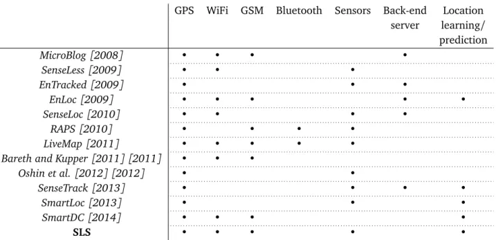
In this dissertation I present the SLS system, which similarly to the related work presented above, aims at providing a continuous localization service, re-ducing the required amount of energy with respect to a standard localization approach. The novelty of the proposed solution with respect to the state of the art consists in: (i) shortening the bootstrap time to learn the user mobility reg-ularities and to predict the next visited locations and departures time; (ii) being adaptive to the current user’s activities (being able to infer the current activity over a set of four main classes), hence very fast in detecting the change of user’s visited contexts; (iii) being implemented and deployed on real smartphones and (iv) being validated not only in an emulated environment (by using datasets of real traces) but also with real experiments.
In table 1.1 I propose a comparison of the SLS with the previously presented energy-efficient location-based solutions, in terms of: technologies used for the localization (e.g., GPS, WiFi, GSM. Bluetooth), sensors usage (e.g., accelerom-eters and other sensors), dependency on back-end servers (as processing units and/or databases), and ability to learn and make predictions based on the mov-ing history, or the capability to learn and predict movmov-ing patterns by means of inertial navigation reasoning (i.e., SmartLoc). Similarly to the state of the art, also the SLS system aims to reduce the energy consumption of a continuous localization procedure, however without impacting the accuracy of the localiza-tion itself and the availability of the service: the system will not only reduce the location sampling frequency to reduce the battery consumption, but it will smartly decide when to use the localization technologies provided by the mobile operating system, according to the user’s history (learned habits and behavior), and to the current context (self adaptiveness). A further innovative aspect of the SLS consists on the fact that the system completely runs into the mobile phone, without relying on a back-end server and without sharing information with other nodes: this characteristic helps in preserving the privacy of the user which does not share any sensitive data with any other nodes or server.
10 1.4 Contributions
GPS WiFi GSM Bluetooth Sensors Back-end Location
server learning/ prediction MicroBlog[2008] • • • • SenseLess[2009] • • • EnTracked[2009] • • • EnLoc[2009] • • • • • SenseLoc[2010] • • • • RAPS[2010] • • • • LiveMap[2011] • • • • •
Bareth and Kupper[2011] [2011] • • •
Oshin et al.[2012] [2012] • •
SenseTrack[2013] • • • •
SmartLoc[2013] • • •
SmartDC[2014] • • • •
SLS • • • • •
Table 1.1. 2: Energy-Efficient Location-Based Solutions comparison
1.4
Contributions
The main focus of this thesis consists in reducing the resource consumption, mainly the battery consumption, due to the localization. However the battery consumption is not a simple function of the localization duty-cycle (as I already mentioned in section 1.2), but it depends on multiple aspects: on the platform (e.g., on the hardware of the mobile device, on the running OS, on its version, etc.) as well as on its usage (e.g., which applications are running on the mobile, and with which frequency the user is interacting with them, etc.) and on the activities of the carrying user. Therefore, the main contribution of this thesis consists in the study and implementation of a smartly dynamic location
duty-cycling which adapts to the actual movements of the user. This is performed by
SLS, implementing an activity inference algorithm which understands whether the user is moving and which is the activity performed. In this way, it performs the localization only when necessary, and adapt the tracking duty cycle to the inferred activity. Additionally, the SLS incrementally learns the user’s mobil-ity behavior and adapts the localization duty-cycles to the location prediction availability: the system performs location prediction instead of a direct location tracking whenever it is possible.
Thanks to its innovative approach, the SLS is expected to outperforms exist-ing solutions for mobile phones, in terms of:
11 1.5 The Goal: Solving the Efficient Localization Problem
• impact of the service on the overall device’s lifetime and on the computa-tional load of the device’s processor;
• service’s response time;
• preservation of the user’s privacy.
In terms of privacy, the advantage of moving the localization computational unit into the mobile device is straightforward (while traditionally it was residing on the server side).
1.5
The Goal: Solving the Efficient Localization
Prob-lem
The localization problem I aim to address with my work, is just beneath the application layer: it regards the acquiring of location information by relying on different technologies, which are not only the standard location tracking tech-niques used nowadays. Smartphones need battery, memory and computational power to perform usual operations. Hence, when adding localization to the set of services provided to the mobile phone’s user, it is crucial to minimize the impact on the phone’s life and overall performance.
The goal of this thesis is to study a localization solution which includes, in addition to the standard location tracking techniques, the support of other technologies, nowadays available on mobile devices; as well as Human Mobility Modelling (HMM) and Machine Learning (ML) techniques (details in chapters 4, 5 and 6), in order to provide a Smart Location Service (SLS) which is expected to outperform existing solutions for mobile phones (Papandrea and Giordano [2012], Papandrea and Giordano [2014], Papandrea [2012]).
To solve the problem stated in section 1.1, my goal is to find out a new way to provide a "broad" localization service exploiting the smartness of these
technologically advanced devices.
In fact, a smart-phone is generally a communication platform, which has a powerful processor (e.g., ARMv8-A 1.4 GHz dual-core Cyclone CPU for the Apple’s iPhone6 and an Nvidia Tegra K1 2.3 GHz dual-core Denver CPU for the HTC Google Nexus9), a great amount of memory (e.g., 2GB RAM for the Google Nexus9, 1 GB RAM for the iPhone6, 2GB RAM for the HTC One), exten-sible internal storage capacity (e.g., 16 or 32 GB flash memory storage for the
12 1.6 Organization of the thesis
Nexus9, 16/64/128 GB flash memory for the iPhone6), sensors embedded (e.g., accelerometer, 3-axis gyroscope, digital compass, barometer, proximity sensor, ambient light sensor, Assisted GPS), different communication interfaces (e.g., Wi-Fi 802.11 a/b/g/n/ac, Wi-Fi Direct, 4G, Bluetooth Low Energy, Near Field Communication) and open operating system (e.g., Android, iOS, Symbian, LiMo, Openmoko, bada).
All these new generation device characteristics give the opportunity to ap-proach the localization problem in a smarter way with respect to the past. We can now merge all the capabilities given by these new technologies to provide a "smarter localization service". The measure of how much smart this new local-ization service is, with respect to existing solutions, is evaluated on the basis of a list of metrics.
1. Impact of the service on the overall device’s life and on the computational load of the device’s processor.
2. Enhancement on the service’s response time.
3. Enhancement in privacy’s issues derived by moving the localization com-putational unit, that traditionally is on the server side, into the mobile device.
Therefore, the evaluation will be performed by means of a comparative study of the continuous localization service provided by the SLS, with two alternative solutions.
1. A very simple localization solution, including only well known technolo-gies, and providing a continuous tracking;
2. A continuous localization service which provide a tracking procedure fairly comparable to the SLS, but using Google APIs for the user’s Activity Recog-nition.
The comparative study will not be a merely comparison of the resources (mainly the energy) used to perform localization, but the evaluation will be performed considering the trade-off of the energy consumed given a number of requirements (e.g., accuracy for outdoor, exchanged network traffic, location availability). Each single module composing the system will be firstly evaluated independently, and subsequently the whole SLS will be validated by means of a real experiment.
1.6
Organization of the thesis
13 1.6 Organization of the thesis
Chapter 2 presents the SLS system from the functional point of view. It deals with the SLS system, whose goal is to manage the trade-off between service ac-curacy and resource usage. The idea behind the proposed system, is to find a criterion which allows the device to receive a continuous localization service, without although having to query continuously the localization engine, hence reducing the resources consumption due to the service. This criterion is driven by two main logic: the first one is the location prediction performed by mod-eling the user’s movements; the second one is the context and activity analysis whereby the device understands whether a query to the localization engine is actually required. In particular, chapter 2 introduces the system architecture, it deals with the analytical study of the SLS and introduces the three main modules which compose the system: the Activity Inference Module, the Learning Module and the Prediction Module.
Since the main target of this thesis is the energy efficiency of the localization on the mobile devices, chapter 3 is focused on the importance and the different methodologies to measure the battery consumption. I present in this chapter the state of the art in this area, and the two different methodologies adopted in this thesis, presenting the pros and cons of each approach. At the end of the chapter I further motivate the work performed for this thesis, by measuring the energy required by a mobile device while performing different tasks (e.g., localization by means of GPS, accelerometer sampling).
The next chapters analyze more in detail each single module of the SLS. Specifically, chapter 4 focuses on the Activity Inference module. It presents the state of the art on this research area and explains in detail the algorithm imple-mented by the SLS, comparing it with the related works, and evaluating it.
Chapter 5 focuses on the Learning Module implemented by the SLS. It presents the state of the art on human mobility modeling and explains in detail the algo-rithm implemented by this module. It analyzes the regularity of human mobility with respect to the locations visited and, in particular, it shows the existence of some patterns according to the relevance of the identified locations. In this chapter I explain the learning algorithm implemented by the SLS, which in the first phase was a graph based algorithm, learning information about consecu-tively visited locations. In a second phase, the algorithm included the timing feature, and associated the user’s visits to relevant locations with their duration and probability distribution during the day. This chapter concludes with some results obtained by analyzing this single module.
Chapter 6 introduces the algorithm implemented by the Prediction module. It presents the prediction based on the learned location-based and location and time-based models. Specific results are shown at the end of the chapter,
evalu-14 1.6 Organization of the thesis
ating the single module.
Chapter 7 presents the complete implementation of the SLS and how the three previously presented modules work together. The chapter presents also a validation section where I show the performances of the SLS against a stan-dard continuous localization service. The validation is performed in terms of battery lifetime against location availability: I show the difference in lifetime for the phone running the SLS and the one running the continuous localization ser-vice, and compare it with the location information availability given by the two services. Furthermore, I compare the SLS against a modified version of the sys-tem, whose Inference Module uses the Google Activity Recognition APIs. These two systems have been compared in terms of mobile phone lifetime, amount of network traffic exchanged, accuracy of the inference. Moreover, I quantify the impact of the prediction on the localization, and I calculate the accuracy on the identification of the PoIs, against the ground truth.
Finally, chapter 8 summarizes the work described in this thesis, it provides an overview of the main findings and results, and it describes the future directions derived from this work.
Chapter 2
System Overview
In this chapter I present the design of the Smart Localization System: and in particular, the architecture of the SLS and its approach to the localization prob-lem presented in the previous chapter (section 2.2). Each module composing the SLS system will be presented separately, together with the logic which is behind them (sections 2.2.1 and 2.2.2). Each module will then be explained in more details and evaluated in the consecutive chapters. At the end of this chap-ter (section 2.3) I present two datasets which have been used to evaluate the SLS modules, and in particular a trajectories and a continuous location dataset. The first one contains data basically collected by people moving among different relevant locations. The second one instead, contains the location data continu-ously collected by some users during their daily routine, hence it includes both locations data collected while moving and while visiting relevant locations.
2.1
Introduction
To clarify the main points already mentioned in the first chapter, I briefly sum-marize here the target working environment of the proposed localization service, the problems that are addressed, the methodologies used and the improvements provided.
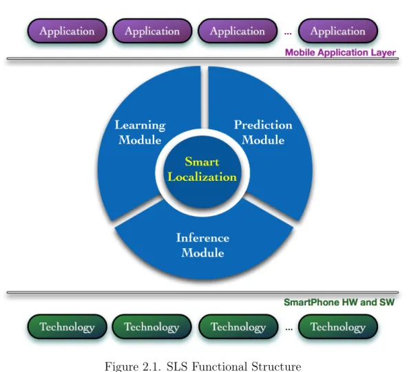
Working environment. Our system is meant to reside beneath the application
layer (as depicted in figure 2.1, which represents the system from a functional point of view, and 2.2 which represents the system from a more technical point of view), and aims to offer it an optimal localization service, which is in charge of providing accurate information, as well as, of managing the mobile device resources. The system is thought for a new generation mobile phone, with a CPU clock rate on the order of GHz (i.e., 2 GHz or more, for the smartphones
16 2.1 Introduction
nowadays available on the market) and memory capacity on the order of GB (i.e., 2GB or more). A set of embedded sensors are available on the platform, such that it can exploit the data sensed by an accelerometer, a GPS receiver, WiFi and GSM interfaces, etc. The target working environment for the system is a broad scenario, which can be thought as the aggregation of almost every human’s accessible places. The ubiquity of the service and the target platform are the most crucial sources of challenges.
Addressed problems. The proposed solution address the issues of a continuous
sensing system, which could be expensive in terms of battery consumption and CPU load, which needs to be responsive and accurate, and has critical security issues.
Methodologies used and improvements provided. The solution I provide to
address these challenges is a combination of different technologies, which does not heavily impact on the overall computational load of the phone and whose portability is characterized by a large scope. The system uses well-known tech-nologies nowadays adopted by already existing localization services, such as GPS, WiFi and GSM, (or more specifically, the Localization Manager provided by mobile Operating Systems: OS-Localization Manager in Figure 2.2) to retrieve location information. These technologies are combined with a human mobil-ity model (HMM Manager in the figure), whose goal is to learn about the users movements, and to allow the system to make predictions (by means of the Pre-diction Manager). For each device, the model starts from scratch and is dynam-ically modified with time. By collecting data, the model incrementally learns about the user’s habits in everyday movements, and adapts itself to the carry-ing user. This is done to avoid unnecessary frequent location measurements, hence worthless battery consumption. The initial phase of incremental learning may require a significant amount of time, depending on the user behavior. After this initial phase the system will be able to exploit the learned information in order to consume less energy. More improvements on the overall system per-formance can be added by the usage of sensed data, performing inferences and adjustments on the movements prediction: for example, the accelerometer read-ings can be used to infer user’s activities; GPS can be used to identify relevant locations.
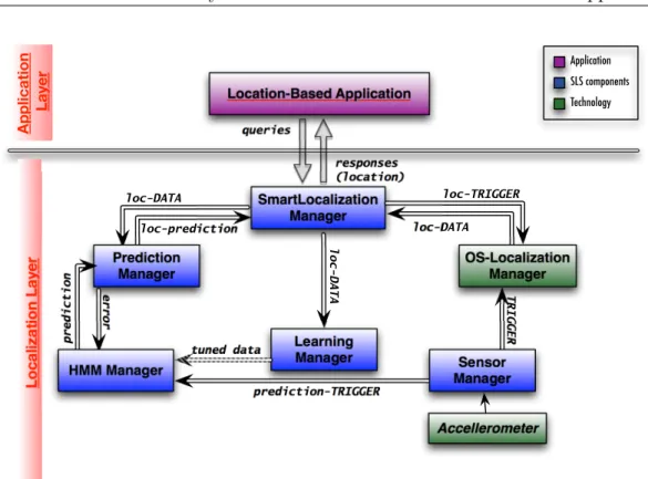
More details about the system architecture (Figure 2.2) will be explained in the following sections, and in the rest of the thesis.
17 2.2 System Overview: the SLS architecture and approach Application Application Application Application Technology Technology Technology Technology SmartPhone HW and SW
Mobile Application Layer
Prediction Module Inference Module Learning Module Smart Localization ... ...
Figure 2.1. SLS Functional Structure
2.2
System Overview: the SLS architecture and
ap-proach
The SLS approach is driven by the two criteria presented in the previous chapter: Personalized Modelling and Optimal Location Reading. The system architecture (figure 2.2) is introduced by Papandrea and Giordano[2012], and includes a set of managers that collaboratively act to collect sensing and location information, learn about user’s behavior and support localization with prediction1. The SLS
exploits the human mobility to learn about personal habits and thus performs prediction based on past user’s behavior. However, as the system performs all the activities without the need of external data analysis systems, i.e. there is no data exchange or external data query, it does not incur in privacy issues.
1The tuned data is transmitted from the Learning Manager to the HMM Manager at precise
18 2.2 System Overview: the SLS architecture and approach Location-Based Application SmartLocalization Manager Learning Manager queries responses (location) loc-DATA loc-TRIGGER loc-DATA loc-prediction OS-Localization Manager loc-DATA tuned data prediction-TRIGGER error Prediction Manager prediction HMM Manager Sensor Manager TRIGGER Accellerometer Localization La y er A pplication La y er Application SLS components Technology Figure 2.2. SLS Architecture
Figure 2.1 gives a functional view of the SLS system. It relies on the tech-nologies (HW and SW built-in functionalities) provided by the mobile phone, represented in the figure by general Technology blocks:
• the OS Localization Manager which retrieves location information using well-known technologies, such as GPS, WiFi and GSM (SmartPhone SW in the figure).
• the HW technologies, such as the accelerometer (SmartPhone HW in the figure).
The SLS approach is centered on a reasoning element, the Smart Localization component, and supported by the following functional modules:
• the SLS Learning and Predicting Modules, which work together to imple-ment the personalized modelling and moveimple-ment predictions;
• the SLS Inference Module, which performs the optimized location reading; The Smart Localization component (SLoc) plays a central role in the SLS ap-proach, it is the “brain” of the system where all the decisions are taken in order
19 2.2 System Overview: the SLS architecture and approach
user in
movement
user static
SLS performs localization user stops moving user starts movingFigure 2.3. SLS State Machine
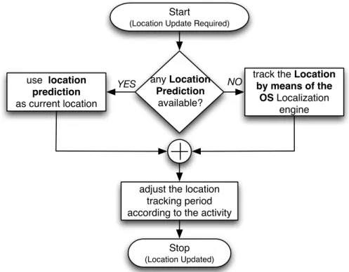
to optimize the localization: whether the prediction is satisfactory or there is still the need to learn about the user by collecting additional location information, or if it is necessary to query the OS Localization Manager, hence to keep active the sensing devices. Figure 2.3 shows the two main states which differentiate the behavior of the SLS: the inference module triggers the events which char-acterize the transition from one state to the other. The localization procedure is performed only when the system is in the “user in movement” state. The high level flowchart of the SLoc component reasoning, while updating the location information, is shown in Figure 2.4.
The smartness of SLS allows the resource (especially battery) consumption management. As we illustrated in Papandrea and Giordano[2012], when a real location based application [Miluzzo et al., 2011] uses the OS Localization Man-ager with continuous location tracking (no duty cycling), the battery lifetime of the phone is quite short. Even if in the future we will have the support of longer lifetime batteries, the tradeoff between battery consumption and optimal localization will remain an issue. To achieve optimal localization while reducing the battery consumption, the SLS approach fosters less frequent location read-ings complemented by less expensive localization techniques (i.e., movement prediction).
20 2.2 System Overview: the SLS architecture and approach
2.2.1
Learning and Prediction Modules
In figure 2.5 we show how the Learning and the Prediction Modules work to-gether within the SLS: the components involved are the Prediction Manager, the Mobility Model Manager and the Learning Manager. Each manager supervises the realization of a specific task, and all together contribute to accomplish the personalized location predictionof the user. The Learning Manager (LMng) stores locally the localization data, performs some mining over it and calculates the pa-rameters which will personalize the prediction model. LMng periodically applies a clustering algorithm2 over the data and retrieves the set of points of interest
(as explained in the next chapters) and related probabilities which are needed by the Mobility Modelling Manager (MMMng). While running, by collecting data, the LMng incrementally learns about the user’s habits and contexts, and allows the MMMng to adapt the model to the learned information.
The MMMng applies the parameters computed by the LMng in the
predic-2In the final version of the SLS the PoIs are retrieved without the need of a clustering
algo-rithms. More details can be found in chapter 7
any Location Prediction
available?
track the Location by means of the OS Localization engine NO YES use location prediction as current location
adjust the location tracking period according to the activity
Start
(Location Update Required)
Stop
(Location Updated)
Figure 2.4. SLS Flowchart: when the user is moving, the SLS tries to predict the location. If this fails, the SLS uses the standard OS tracking techniques.
21 2.2 System Overview: the SLS architecture and approach Location data Learning Manager Mobility Model Manager Prediction Manager db Location prediction write read/ write read
Figure 2.5. SLS Learning and Prediction Modules Architecture
tion mobility model; finally, the Prediction Manager (PMng) uses the model for predicting the next user movements (see chapter 6) and for calculating the pre-diction error with respect to the real locations, when the user is approaching it.
Before starting any localization procedure, the SLoc component interrogates the Prediction Module in order to check if there is any available prediction about the next movement. If available and reliable (more details about the prediction reliability are explained in chapter 7), it just takes the prediction as current position. If no prediction is available, the SLoc triggers the Operating System Localization manager (OSLMng).
For each device, the SLS starts the Mobility Model from scratch and dynam-ically modifies its parameters with time to personalize the predictions. Clearly, during the Start Up phase (from the first run of the system, until the model has been generated), the localization is performed only using the node’s tracking technologies (OSLMng), as the SLS still need to personalize the mobility model to the carrying user.
When the location prediction error value goes below a given threshold, the bootstrap phase of the prediction model is considered completed. At this point, the localization procedure starts using the Prediction Module for the localization, and decreases the triggering frequency of the OSLMng. This personalization of the model further allows (in addition to "the user is moving?" check) to avoid unnecessary frequent location measurements, as several habits and contexts are known, hence it prevents worthless battery usage. In terms of battery consump-tion, initially the system does not gain anything with respect to other techniques in literature. The real advantage is visible at the end of the bootstrap phase,
22 2.2 System Overview: the SLS architecture and approach Accelerometer Sensor Manager Gyroscope Compass Activity inference other sensing technologies Magnetic Field
Figure 2.6. SLS Inference Module Architecture
after which the node starts decreasing the frequency of direct location tracking, alternating them with predictions.
2.2.2
Inference Module
The Inference Module, as illustrated in Figure 2.6, is composed by the Sensor Manager which interacts directly with some mobile phone HW components.
The Sensor Manager (Smng), based on some mining on the data collected by the sensors, infers the activity of the user and sends back this information to the SLoc component which decides its actions based on the activity of the user:
1. if the user is static, the SLoc component returns the last tracked location (the user did not move since the last location reading);
2. if the user is moving, the SLoc component changes the tracking frequency (interval of time between consecutive location readings) according to the actual activity of the user.
The purpose of this inference is to reduce the resources usage, by adding flexibility in the localization procedure. While the user is static, there is no need to perform location readings, because the location does not change until the next movement. While the user is moving, according to the kind of movement the localization procedure may be different, in order to retrieve location data with similar accuracy: in particular, if the user is moving slowly (i.e., walking), a less frequent location reading allows the system to track all the movements of the user, while if the user is moving faster (i.e., travelling on a vehicle) it is necessary to perform more frequent location reading.
23 2.3 Dataset
Differently from traditional approaches in literature, the SLS performs infer-ences on the user’s activity without the need of a back-end server for the data elaboration. The activity classification algorithm is lightweight to run efficiently on the client side.
To identify the user status, the Sensor Manager analyzes the three axis ac-celerometer data, calculates a set of features over it and applies a classification algorithm to the features. I selected a set of features which allow the system to distinguish between different categories of movement:
• not moving (e.g., still or standing), • moving by foot (e.g., walking, running), • slow vehicle (i.e., biking) and
• moving with a vehicle (e.g., motorbike, car, bus, train).
The classification algorithm has been chosen in order to optimize the trade-off between the simplicity of the algorithm itself (which has to run entirely on the mobile device) and the accuracy of the activity classification: our goal is to ex-ploit a lightweight classification algorithm which performs a reliable inference, guaranteeing a limited impact on the mobile device resources usage (more de-tails in chapter 4).
The presence of the Inference Module inside the SLS is beneficial because it allows a reduced energy consumption: inferring the real activity of the users, the Inference module makes the system self-adaptive and hence able to avoid unnecessary location readings.
2.3
Dataset
To validate my work I performed the preliminary studies (before the realiza-tion of the complete system) over two locarealiza-tion datasets. Unfortunately, for most of the publicly available location datasets the data corresponds to trajectories [Bracciale et al., 2014], or to WiFi or GSM continuously sampled data [CRAW-DAD data set Microsoft/Vanlan (v. 2007-09-14), 2007], or to data collected in a small context (e.g., a mall, a university campus)[Rhee et al., 2009; CRAWDAD data set cu/cu_wart (v. 2011-10-24), 2011] or for a small time (i.e., a conference scenario). To show the performances of our system and to evaluate our solutions we need a continuous sampled location dataset collected over a long sampling duration. Similarly, we need a level of precision that is higher than the one we
24 2.3 Dataset
can obtain with traditional WiFi or GSM technologies. The datasets we used are: one mainly composed of trajectories (selecting a subset of the data which presents only few discontinuities), and the second one which consists of contin-uously sampled location data. In the following by using the term trajectory we mean a sub-sequence of a continuously sampled location data: trajectories are discontinuous records of mobility data and consequently they do not cover the whole sampling period. These datasets have different characteristics in terms of spatial and temporal distribution of the visited places. However for both of them we only consider the PoIs in terms of geographical places without seman-tic meaning. We make this decision for two main reasons: firstly to preserve the privacy of the users (users may have issues revealing why did they visit a certain location). A second reason is the fact that a PoI is not an exact location, its dimension (or geographical scope) depends on how the user visits the place: hence a PoI can be a shopping area where the user roams around (which may include shops, restaurants, bars,... ), or an office where the user spends most of her/his time sitting in the same location. By showing the validity of our results in both cases, we demonstrate its independence of the dataset characteristics.
2.3.1
Trajectories Dataset
As trajectories dataset I used the one collected by the GeoLife project and re-leased by Microsoft Research Asia (Zheng et al. [2009, 2008, 2010]). The dataset consists of a collection of GPS coordinates related to the movements of 178 people in a period of over 4 years (from April 2007 to October 2011), and it is widely distributed across over 30 cities of China and even in some cities located in the USA and Europe. People participating to the experiment are students, government staff and employees from Microsoft and several other companies equipped with GPS loggers or GPS-phones. Overall the dataset pro-vides 17.621 trajectories 3 with a total distance of 1, 251, 654 kilometers and
a total duration of 48, 203 hours. With respect to other datasets with mobility data collected in a limited area or in a particular context, Geolife dataset offers a high heterogeneity. As a matter of fact, it contains a broad range of users’ outdoor movements, including both everyday routines imposed by working ac-tivities and free time acac-tivities. For my study, which is centered on the locations visited by the users during their daily lives, the most interesting characteristic of this dataset is its temporal and spatial fine granularity, as 91% of the GPS
tra-3A GPS trajectory of the dataset corresponds to a set of consecutive location samples
25 2.3 Dataset
jectory are recorded with a dense representation, every 1∼ 5 seconds or every 5∼ 10 meters per location sample. However, the dataset has been built for the transportation prediction task, and thus does not directly characterize the Points of Interest4. Furthermore, if on the one hand the dataset is very rich, on the
other side it exhibits an high level of fragmentation, especially with regard to features as the effective duration of the trajectories, the data collection period, the number of trajectories per user, the duration of the gaps between discon-tinuous trajectories. Indicatively, more than half of the trajectories spans less than one hour, while about 60% of users collected data for less than a month. For those reasons, GeoLife dataset requires large pre-processing for reducing the trajectory points and extracting the visited points. This modification affects also the suitable number of users and the daily traces, per user, from which we can extract the PoIs.
2.3.2
Continuous Dataset
Although GeoLife represents the most reliable dataset publicly available for our purpose, even after preprocessing, its nature still remains trajectory centered, and it differs from a continuously sampled dataset. As opposite to the Microsoft one, which is a large dataset collected in a metropolitan area, I supervised a local collection campaign to retrieve a dataset of continuously sampled GPS co-ordinates, during users’ daily routine, in a small area environment. A real ex-periment has been conducted to collect traces in the area of Ticino and North Italy, over a time period of 20 days, from a group of 12 users (Papandrea and Giordano [2014]). The data collection system have been installed on the pri-mary mobile phone of the users, to ensure they continuously carry it with them. Different devices running several versions of the Android OS (table 2.1) have been used to collect data.
The mobile phone sampling service performs a location reading every 60 sec-onds, and works both outdoor and indoor. The location information is provided by the Android OS Localization Manager which queries both GPS and Network (WiFi or GSM) Providers. The service selects the best location information avail-able at each sampling minute, and stores locally the retrieved data. The service runs continuously, collecting data 24 hours per day in the best case, for the whole duration of the experiment. For privacy reasons, we allowed the users to manually pause the service. Thus, the collected data is not always a 24 hours
4Point of Interest (PoI) is an interesting location for a user, where she/he spends a relevant
26 2.4 Conclusion
Device Model Adroid Version
Samsung Nexus S 4.0.4 HTC Nexus One 2.3.6 HTC Desire Z 2.3.3 Samsung Galaxy II S 2.3.4 Garmin-Asus nuvifone MP 2.1.1 Samsung GT I9100 2.3.3 LG-P920 2.3.5 HTC Hero 2.1.1 LG-P990 2.3.4 HTC Desire 2.3.7 HTC Sensation 4.0.3 Motorola Milestone BP6X 2.1.1 Table 2.1. Devices Specifications
continuous data, but may present some gaps. Also from this dataset I select a subset of significant users which have collected a significant amount of data. More specifically, I selected the users which collected at least 14 relevant days of data (two weeks), where a relevant day includes at least 6 hours of location sampling. The resulting number of relevant users considered for my study is 6.
2.4
Conclusion
In this chapter I presented the solution to the localization problem, proposed in this thesis. I presented each module composing the SLS from the functional point of view. The Inference module is in charge of exploiting the potentialities of the accelerometer to enhance the localization procedure, and in particular it helps the SLS to adapt its behavior according to the actual activity of the carrying user. The Learning module and the Prediction module exploit the computational capabilities of the mobile device, and learn information about the mobility habits of the user, in order to be able to predict the next movements.
All these modules will be better explained in the next chapters: they will be firstly evaluated separately and independently from the system. At the end of the thesis the modules will be presented and evaluated as part of the whole SLS system.
Chapter 3
Analysis of Battery Consumption
3.1
Introduction
In this chapter I present two different methodologies to evaluate the battery consumption on Android mobile devices. The main purpose of this thesis devel-opment is to study and to realize a smart methodology for a continuous local-ization service for mobile devices. Therefore, to be able to evaluate the system and to show its validity in terms of smart usage of the battery, it is essential to firstly analyze the measurement possibilities.
Many existing works related to the smart usage of the mobile device’s re-sources/hardware proposed different solutions for the battery measurement. In Wang et al. [2009], the authors measured the sensor power consumption of their employed mobile devices (Nokia N95) through the Nokia Energy Profiler, a stand-alone application that allows the monitoring of the running applications’ energy usage in real time. Lin et al.[2010] experimentally measured the energy usage for multiple location modalities on an AT&T Tilt (HTC TyTN II) mobile phone, removing the battery and supplying the power by means of a Monsoon Solutions Power Monitor. This approach is very similar to the one implemented in this thesis, and presented below in section 3.3. Also Paek et al. [2010] used the Power Monitor device from Monsoon Solutions Inc. for their power mea-surements and cross-verified them with the Nokia Energy Profiler v1.2 software tool (they performed their studies with the Nokia N95 smartphone). In Flipsen et al. [2012] the authors studied the power breakdown of five different smart-phones, measuring the power consumption by means of an Agilent N6705A DC Power Analyser, and emulating the battery with an Agilent Power Analyser and attaching probes to the battery input pins present on the smartphone. This last approach is very similar to our implemented one, however for many mobile
28 3.2 Differentiation of localization procedures
vices this methodology is not applicable (for example, for the HTC Google Nexus One phone), where the device implements a general check of the hardware com-ponents at the bootstrap: the ah-hoc battery necessary to connect the mobile phone to the power supply and to the multimeter is not recognized as a compat-ible component, and the device does not switch on. An interesting approach has been described by Ferrari et al. [2014] which presented POEM (Portable Open Source Energy Monitor). This system allows the measurement of the energy consumption of every single Android application component down to the con-trol flow level. Their approach is based on the Arduino Leonardo board, which is basically used to read the current flowing into the mobile device.
All these approaches described in the state of the art are very interesting, and allows a fine grained measurement of the mobile device energy consumption. However, they have a common drawback: they are static systems which do not allow the energy measurement while the mobile device is carried by the user.
I present in this chapter two measurement procedures. These are applied in the thesis for the battery consumption estimation for both static measurements and evaluation of mobile scenarios. In section 3.2 I show the difference between two localization procedures by means of the Android API and their different impact on the battery resource. In section 3.3 I explain the two battery mea-surements methodologies I applied while developing and evaluating this thesis, explaining the pros and cons of both approaches. Finally in section 3.4 I show the difference in battery consumption for different tasks on the mobile device, and especially for the tasks performed by the SLS: this evaluation motivates the SLS reasoning explained in the following chapters of the thesis.
3.2
Differentiation of localization procedures
The localization is an expensive task for a mobile device, in terms of battery consumption. The amount of battery necessary to localize a user strictly depends on two factors: on the methodology used to perform the localization and on the user’s mobility. The study reported on this thesis has been performed by using Android mobile platforms.
Android offers mainly two data sources to retrieve location information: • the GPS provider, which requires the line-of-sight to GPS satellites and
retrieves in most of the cases very accurate location data;
• the NETWORK provider, which retrieves a more coarse location informa-tion exploiting the WiFi and GSM interfaces.