Publisher’s version / Version de l'éditeur:
Vous avez des questions? Nous pouvons vous aider. Pour communiquer directement avec un auteur, consultez la
première page de la revue dans laquelle son article a été publié afin de trouver ses coordonnées. Si vous n’arrivez pas à les repérer, communiquez avec nous à [email protected].
Questions? Contact the NRC Publications Archive team at
[email protected]. If you wish to email the authors directly, please see the first page of the publication for their contact information.
https://publications-cnrc.canada.ca/fra/droits
L’accès à ce site Web et l’utilisation de son contenu sont assujettis aux conditions présentées dans le site LISEZ CES CONDITIONS ATTENTIVEMENT AVANT D’UTILISER CE SITE WEB.
Proceedings of the International Conference on Conceptual Structures 2007
(ICCS 2007), 2007
READ THESE TERMS AND CONDITIONS CAREFULLY BEFORE USING THIS WEBSITE.
https://nrc-publications.canada.ca/eng/copyright
NRC Publications Archive Record / Notice des Archives des publications du CNRC :
https://nrc-publications.canada.ca/eng/view/object/?id=667ce664-8211-47ed-9ee2-1906d32b7622
https://publications-cnrc.canada.ca/fra/voir/objet/?id=667ce664-8211-47ed-9ee2-1906d32b7622
NRC Publications Archive
Archives des publications du CNRC
This publication could be one of several versions: author’s original, accepted manuscript or the publisher’s version. / La version de cette publication peut être l’une des suivantes : la version prépublication de l’auteur, la version acceptée du manuscrit ou la version de l’éditeur.
Access and use of this website and the material on it are subject to the Terms and Conditions set forth at
Visual data mining of symbolic knowledge using rough sets, virtual
reality and fuzzy techniques: an application in geophysical prospecting
Visual Data Mining of Symbolic Knowledge
using Rough Sets, Virtual Reality and Fuzzy
Techniques: An Application in Geophysical
Prospecting*
Valdés, J.
2007
* Proceedings: ICCS 2007. Lecture Notes in Computer Science/Lecture Notes in Artificial Intelligence Series. 2007. NRC 49300.
Copyright 2007 by
National Research Council of Canada
Permission is granted to quote short excerpts and to reproduce figures and tables from this report, provided that the source of such material is fully acknowledged.
Visual Data Mining of Symbolic Knowledge using
Rough Sets, Virtual Reality and Fuzzy Techniques: An
Application in Geophysical Prospecting
Julio J. Vald´esNational Research Council Canada Institute for Information Technology M50, 1200 Montreal Rd.,Ottawa, ON K1A 0R6
WWW home page: http://iit-iti.nrc-cnrc.gc.ca
Abstract. Visual data mining using nonlinear virtual reality spaces (VR) is ap-plied to symbolic knowledge in the form of production rules obtained by rough sets methods in a classification problem with partially defined and imprecise classes. In the context of a geophysical prospecting problem aiming at finding underground caves, a virtual reality nonlinear space for production rules is con-structed. The distribution of the rough sets derived rules is characterized by a fuzzy model in both the original 5D space and in the 3D VR space. The member-ship function of the target class (the presence of a cave) is transferred from the rules to the data objects covered by the corresponding rules and mapped back to the original physical space. The fuzzy model built in the VR space predicted sites where new caves could be expected and one of them was confirmed.
1
Introduction
While applied frequently to databases, visualization techniques have not been applied often to the analysis of symbolic information. However, symbolic knowledge like for example, sets of production rules, are difficult to interpret for humans because of their more abstract nature and this is where visual methods become important aid. The pur-pose of this paper is to show that in addition to the understanding of symbolic knowl-edge provided by visual techniques, in particular virtual reality spaces [9], [11], math-ematical models can be derived from the geometric properties of the symbolic objects in these spaces which can solve complex classification problems. In particular, situa-tions where some of the classes are undefined because of lack of knowledge about class membership and where in addition, the classes themselves are fuzzy.
A general approach is proposed consisting of: i) use rough sets techniques for learn-ing production rules from the original data uslearn-ing the imperfectly defined class labels ii) construct a nonlinear virtual reality space preserving the structure of the rules, iii) per-form a data analysis in the new and the high dimensional space of the rules, iv) construct a fuzzy model based on the geometric properties of the rules in these spaces, v) induce the membership functions of the known classes to the database objects covered by the rules. This approach is applied to a real-world problem: the geophysical prospecting of
2 Julio J. Vald´es
caves, where class membership can be defined only for a certain subset of the database objects and where the classes (presence/absence of a cave) are fuzzy.
2
Virtual Reality Representation of Information Systems
Several reasons make Virtual Reality (VR) a suitable paradigm: it is is flexible, it allows immersionand creates a living experience. Of no less importance is the fact that in or-der to interact with a virtual world, no mathematical knowledge is required. A virtual reality based visual data mining technique, extending the concept of 3D modeling to information systems and relational structures, was introduced in [9], [11]. It is oriented to the understanding of large heterogeneous, incomplete and imprecise data, which in-cludes symbolic knowledge. The objects are considered as tuples from a heterogeneous space ˆHn[10]. A virtual reality space is the tupleΥ =< O, G, B, ℜm, g
o, l, gr, b, r >,
whereO is a relational structure (O =< O, Γv > , the O is a finite set of objects, and
Γv is a set of relations),G is a non-empty set of geometries representing the different
objects and relations. B is a non-empty set of behaviors of the objects in the virtual world. ℜ is the set of real numbers and ℜm
⊂ Rmis a metric space of dimensionm
(Euclidean or not) which will be the actual virtual reality geometric space. The other elements are mappings:go: O → G, ϕ : O → ℜm,gr: Γv→G, b : O → B.
Several desiderata can be considered for building a VR-space [11]. From an unsu-pervised perspective, the role ofϕ could be to maximize some metric/non-metric struc-ture preservation criteria (e.g. similarity) [2]. Ifδij is a dissimilarity measure between
any twoi, j ∈ U (i, j ∈ [1, N ], where N is the number of objects), and ζivjvis another
dissimilarity measure defined on objectsiv, jv∈O from Υ (iv = ξ(i), jv= ξ(j), they
are in one-to-one correspondence). An error measure frequently used is [7]: Sammon error = P 1 i<jδij P i<j(δij−ζiv,jv)2 δij (1)
3
The Data Mining Process
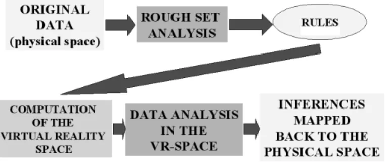
The original data is processed with Rough Sets techniques and rules are obtained re-lating the prediction attributes with the classes ( this result is considered partial, if not all of the class are known). Then a virtual reality space for the obtained rules is built (using the method of Fletcher-Reeves [5]) and an analysis of the rules in the original and in the new spaces is made. Finally, the results of the analysis are mapped back into the original physical space for interpretation. Fig.-1.
3.1 Application to a Geophysical Prospecting Problem
Cave detection is a very important problem in civil and geological engineering. Typi-cally caves are not opened to the surface and geophysical methods are required for their detection, which is a complex task. In a pilot investigation, geophysical methods and a topographic survey were used with the goal of deriving criteria for predicting the pres-ence of underground caves [8]. In the studied area, a cave was known to exist, but the
Visual Data Mining of Symbolic Knowledge using Rough Sets 3
Fig. 1: The data analysis process.
presence of others was suspected. This is a problem with partially defined classes: the existence of a cave beneath a measurement station is either known for sure or unknown (i.e. only one class membership is really defined). Moreover, the classes themselves are also imprecise or fuzzy, as there are no sharp boundaries between the classes. The prob-lem is not the typical two-classes presence/absence one because only one class is known with certainty: a combination of unsupervised and supervised approaches is required.
Five geophysical methods were measured on a regular grid containing1225 mea-surement stations (the objects) [8]. The measured fields were: i) the spontaneous electric potential (SPdry) at the earth’s surface measured during the dry season, ii) the vertical
component of the electro- magnetic field in the VLF region of the spectrum (frequency range [3 − 30] kHz), iii) the spontaneous electric potential measured during the rainy season (SPdry), iv) the gamma ray intensity (Rad) and v) the topography (Alt). A data
preprocessing process was performed consisting of: i) conversion of each physical field to standard scores (zero mean and unit variance), ii) model each physical field f as composed of a trend, a signal and additive noise: f (x, y) = t(x, y) + s(x, y) + n(x, y) wheret is the trend, s is the signal, and n is the noise component, iii) fitting a least squares two-dimensional linear trend ˆt(x, y) = c0+ c1x + c2y and computation of the
residual: r(x, y) = f (x, y) − ˆˆ t(x, y) , iv) Convolution of the residual with a low-pass zero-phase shift two-dimensional digital filter [3] to attenuate the noise component, and v)Re-computation of the standard scores and addition of a class attribute indicating whether a cave is known to exist below the corresponding measurement station or if it is unknown. The pre-processed data set will be called prp-data.
Rough set analysis was performed using the Rosetta system [6]. The prp-data was discretized using the Boolean Reasoning algorithm and reducts were computed. Only one reduct was found containing all of the five attributes, indicating that none of the observed geophysical fields can be discarded without loosing discernibility. A set of 345 rules were obtained from the reduct and the following are two examples:
4 Julio J. Vald´es
SPdry([*, -1.50209)) AND VLF([*, -1.14882)) AND SPrain([*, -0.46789)) AND Rad([*, -1.54413)) AND Alt([*, -1.22398)) => (CAVE is present) (6 objects)
SPdry([-0.16981, *)) AND VLF([-0.75462, *)) AND SPrain([0.48744, *)) AND Rad([-0.21015, *)) AND Alt([0.00346, *)) => (CAVE is unknown) (123 objects)
For each pair of rules, a similarity measure was computed using the condition at-tributes. In this case the measure used was Gower’s coefficient (s) [4], converted into a dissimilarity measureδ using the transformation δ = (1/s) − 1. A VR-space mini-mizing Eq.1 was computed as described in [9], [11] and a snapshot is shown in Fig.2 as a static picture. Each sphere is a rough set rule from the knowledge base: dark objects represent rules leading to the Cave class and lighter objects represent rules leading to the Unknown class. The wrapping surface is the convex hull of the Cave class wrapping all of its rules (computed according to [1]) and the star indicates its centroid. There are rules leading to the unknown class which are within the hull of the cave class, indi-cating that they are similar to those concluding about the presence of a cave. Another subset of the rules concluding about the unknown class is located outside of the surface enclosing the set of rules of the cave class. They are more representative of the no-cave situation. In Fig.2, the distanced between any rule in the space and the centroid of
Fig. 2: Snapshot of the VR space containing the rules obtained via Rough Sets. Dark objects: cave class. Light objects: unknown class. Many objects of the unknown class are within the cave class.
the Cave class is shown. The distance between any rule in the space and this centroid gives an indication about how similar the corresponding rule is of being a descriptor of the cave properties as an abstract concept. This notion can be formalized as a fuzzy
Visual Data Mining of Symbolic Knowledge using Rough Sets 5
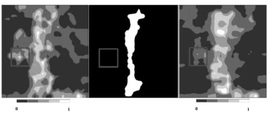
Fig. 3: Spatial distribution of the µcavefunction derived from the rough sets rules. Left: µcave
from the original 5-D space. Center: The area with the known cave. Right: µcavefrom the VR
space. In all images, a square shows the area where a borehole hit a previously unknown cave.
property with a membership function constructed, among many others, as: µcave(ri) = 1 −
d(ri, c)
dmax
(2) whereµcave(ri) is the membership of rule ri to the cave class,d(ri, c) is the distance
between the i-th rule and the centroid c of the cave class and dmax is the maximal
distance between the centroid and the farthest rule.
Twoµcave functions were computed: i) in the original5-D space of the attributes
appearing in the condition part of the rules and ii) in the VR 3-D space. Since rules are abstract symbolic entities (without any physical location), these results have to be mapped back to the physical space. This was done by transferring the membership to the cave class from each given rule to the objects covered by the rule, which correspond to the measurement points on the earth’s surface (the physical space). Thus, each fuzzy membership functionµcave(ri) of the rules leads to a two dimensional fuzzy
member-ship function of the objects with respect to the cave classµcaveoj(x, y), where (x, y)
are the coordinates corresponding to the j-th data objectoj, covered by ruleri. The
distribution of the fuzzy memberships computed in the original 5-D space and in the 3-D VR-spaces are shown in Fig.3.1(left and right respectively), as well as the map of the area, with the location of the known cave (Fig.3.1-center).
The fuzzy membership function in the original 5D space (Fig.3.1-left), has a central narrow band of high values which corresponds to the location of the known cave. In addition, there are other areas of high values located at the center-left and bottom-right, both beyond the outline of the surveyed cave. This suggests the presence of other caves, not opened to the surface. These areas are wrapped by a medium membership value enclosure emerging from the one enclosing the known cave which suggests that they might be a part of the same cave system.
A similar behavior is exhibited by the fuzzy membership function in the nonlinear VR space, shown in Fig.3.1 bottom-left. The patterns observed are the same in terms of the appearance of a central band of high values and the two additional areas of high
6 Julio J. Vald´es
membership values. The results can be perceived as more clear because the function is smoother. This indicates that the information lost during the nonlinear mapping of the original 5D space to the 3D space actually increased the signal to noise ratio, which is a very important feature. Some time after the geophysical investigation was made, a borehole was drilled in the location corresponding to the center-left area of high mem-bership indicated above. A a cave was hit, thus confirming the results suggested by the presented approach.
4
Conclusions
Visual data mining of symbolic knowledge obtained with rough sets proved to be effec-tive in understanding complex problems with partially defined and imprecise classes. Fuzzy models derived from the original rough set rules and from a virtual reality space obtained from them by nonlinear mapping, revealed the essential properties of the target class. In the studied case of a geophysical prospecting problem, it allowed the identifi-cation of areas where the presence of new hidden caves could be expected and one was confirmed by drilling. The comparisson of the fuzzy membership function in the orig-inal and in the VR space turned out to be a very effective noise reduction filter, which also preserves most of the information associated with the target class. This approach is domain-independent and could be applied to similar problems in other areas.
References
1. Barber, C. B., Dobkin, D. P., Huhdanpaa, H. T.: The Quickhull algorithm for convex hulls. ACM Trans. on Mathematical Software, 22(4),(1996). pp469–483.
2. Borg, I., and Lingoes, J., Multidimensional similarity structure analysis: Springer-Verlag, (1987), 390 p.
3. D.E. Dudgeon, R.M. Mersereau. Multidimensional Signal Processing. Prentice Hall, 1984. 4. Gower, J.C., A general coefficient of similarity and some of its properties: Biometrics, v.1, no.
27, p. 857–871. (1973).
5. Press, W.H.,Teukolsky S.A., Vetterling W.T., Flannery B.P: Numerical Recipes in C. The Art of Scientific Computing. Cambridge Univ. Press, 994 p. (1992).
6. Øhrn A., Komorowski J.: Rosetta- A Rough Set Toolkit for the Analysis of Data. Proc. of Third Int. Join Conf. on Information Sciences (JCIS97), Durham, USA, (1997), 403–407. 7. Sammon, J.W. A non-linear mapping for data structure analysis. IEEE Trans. on Computers
C18, p 401–409 (1969).
8. Vald´es J.J, Gil J. L. Joint use of geophysical and geomathematical methods in the study of experimental karst areas. XXVII International Geological Congress, pp 214, Moscow, 1984. 9. Vald´es, J.J.: Virtual Reality Representation of Relational Systems and Decision Rules: An
ex-ploratory Tool for understanding Data Structure. In Theory and Application of Relational Structures as Knowledge Instruments. Meeting of the COST Action 274 (P. Hajek. Ed). Prague, November 14–16, (2002).
10. Vald´es, J.J : Similarity-Based Heterogeneous Neurons in the Context of General Observa-tional Models. Neural Network World. Vol 12, No. 5, pp 499–508, (2002).
11. Vald´es, J.J.: Virtual Reality Representation of Information Systems and Decision Rules: An Exploratory Tool for Understanding Data and Knowledge. Lecture Notes in Artificial Intelli-gence LNAI 2639, pp. 615-618. Springer-Verlag (2003).