HAL Id: hal-00297049
https://hal.archives-ouvertes.fr/hal-00297049
Submitted on 2 Jan 2008
HAL is a multi-disciplinary open access
archive for the deposit and dissemination of
sci-entific research documents, whether they are
pub-lished or not. The documents may come from
teaching and research institutions in France or
abroad, or from public or private research centers.
L’archive ouverte pluridisciplinaire HAL, est
destinée au dépôt et à la diffusion de documents
scientifiques de niveau recherche, publiés ou non,
émanant des établissements d’enseignement et de
recherche français ou étrangers, des laboratoires
publics ou privés.
Southern Perú coseismic subsidence: 23 June 2001
8.4-Mw earthquake
L. Ocola
To cite this version:
L. Ocola. Southern Perú coseismic subsidence: 23 June 2001 8.4-Mw earthquake. Advances in
Geo-sciences, European Geosciences Union, 2008, 14, pp.79-83. �hal-00297049�
www.adv-geosci.net/14/79/2008/ © Author(s) 2008. This work is licensed under a Creative Commons License.
Geosciences
Southern Per ´u coseismic subsidence: 23 June 2001 8.4-Mw
earthquake
L. Ocola
Instituto Geof´ısico del Per´u, Sector Educaci´on, Calle Badajoz 169, Lima 3, Per´u
Received: 1 June 2007 – Revised: 20 August 2007 – Accepted: 24 August 2007 – Published: 2 January 2008
Abstract. The 23-June-2001 8.4-Mw magnitude earthquake partially filled the 1868-seismic-gap in southern Per´u. This earthquake produced a thrust faulting dislocation with a rup-ture that started at about ∼200 km SE from the 1996’s Nazca earthquake epicenter, and stopped near Ilo, at about 300 km from the epicenter, near a positive gravity anomaly offshore Ilo. The 23-June-2001-earthquake dislocation zone is under the Arequipa sedimentary Basin. Pre- and post-seismic GPS measurements at Caman´a and Ilo at SIRGAS-GPS points (SIRGAS: Sistema de Referencia Geoc´entrico para Am´erica del Sur) and the average sea level pre- and post-seismic event at Mollendo tide gauge provide evidence of a regional sub-sidence of southern Per´u, with 84 cm at Caman´a, 16 cm at Ilo, and 15 cm at Mollendo. Field surveys post earthquake document significant subsidence in Caman´a resort beaches. Results of a simple dislocation modelling of 23-June-2001 earthquake agree reasonably well with the observed data. However, the coseismic subsidence of southern Per´u is at variance with the regional uplift of southern Per´u based on Neotectonic studies. This fact, suggests that, in recent geo-logical times, the magnitude of the secular uplift due to tec-tonic plate converge has been larger than the coseismic de-formation recovery.
1 Introduction
On 23 June 2001, an 8.4-Mw-magnitude earthquake struck Southern Per´u causing severe damage on the built and natu-ral environments. The Geophysical Institute of Per´u (IGP) locates the hypocenter at 16.462◦±3.9 km south latitude,
73.936◦±2.5 km west longitude and 30.4 km±9.5 km depth
using data from the IGP’s local seismic networks. The max-imum severity of ground shaking was 7− MSK (Tavera et
al., 2006). The earthquake was produced by a thrust fault-ing mechanism with a minor sinistral strike displacement component (e.g., Harvard Centroid Moment Tensor solution,
Correspondence to: L. Ocola
(geo gps@geo.igp.gob.pe)
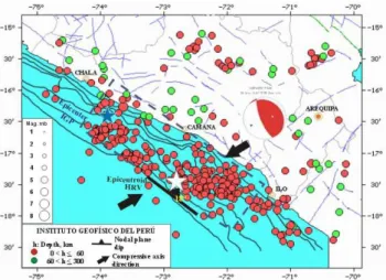
NEIC, 2005; Tavera et al., 2002). According to Harvard’s focal mechanism solution, one of the nodal planes has 310◦ strike and 18◦dip, and 63◦slip angle. The other nodal plane has strike, dip and slip angle: 159◦, 74◦and 98◦, respectively, the centroid is located at Lat. 17.28◦S, Lon. 72.71◦W, and 29.6 km depth (NEIC, 2005) (Fig. 1).
2 Geophysical setting
The bulk of the geophysical-oceanographic systematic data, and knowledge of the Nazca Plate and neighbouring areas shallow structure come form the Nazca Plate Project of the International Decade of Ocean Exploration Program, carried out by the Hawaii Institute of Geophysics and the Oregon State University with the participation and collaboration of several South American scientific institutions, like the Insti-tute of Geophysics of Per´u (Kulm et al., 1981). In this sec-tion, some of the relevant information related to the 23-June-2001-earthquake source region is summarized.
The 23-June-2001-earthquake is located SE of the Nazca Ridge. The epicenter is east of the Per´u-Chile trench deepest part (>7000 m), offshore of southern Per´u. The spatial di-mension of the dislocation rupture, as estimated from the af-tershock distribution and source modelling, is under the Are-quipa fore-arc sedimentary basin. The earthquake epicen-ter is located near the NW basin’s boundary and the rupture stopped close to its SE boundary, near Ilo, in the transition zone of Arequipa-Arica Quaternary sedimentary basins.
According to Johnson and Ness (1981), the Arequipa Basin (Mollendo basin of Couch and Whitsett, 1981) lies from 16◦to 18◦S latitude along the southern Per´u coastline,
under 100–1500 m water depth. It is a prominent elongated feature of regional size that lies “landward of a tectonically formed upper-slope break” (Johnson and Ness, 1981, p. 542). It has a broad synclinal axis, and occasionally exhibits mi-nor faulting. A seismic reflection profile, 100 km NW of Mollendo, “reveals a continental slope with very irregular topography that extends from the trench nearly to the coast-line. The topmost sediments appear disturbed and the general
80 L. Ocola: Southern Per´u coseismic subsidence: 23 June 2001 8.4-Mw earthquake
Figure 1. June-23-2001-earthquake approximate rupture area
Fig. 1. June-23-2001-earthquake approximate rupture area (rectan-gle) and four years of >4.4 mb magnitude earthquakes in the rupture and neighbouring areas. White star: Epicentroid.
Figure 2. Chase (1968) bathymetry, Subsidence of
ent vectors.
Fig. 2. Chase (1968) bathymetry, Subsidence of Caman´a (C) and Ilo (I) determined from GPS data, Matarani (M) tide-gauge subsidence determined from tide-gauge analog records (Koshimura and Sato, 2005). Arrows show GPS horizontal displacement vectors.
shape of the slope suggest block faulting on a large scale” (Couch and Whitsett, 1981), with seaward convergence of sedimentary reflectors against the outer structural high. John-son and Ness (1981, p. 538–539) mentioned “Thinning of layers towards the outward structural high is evidence for ei-ther the gradual uplift of the slope break or the down warping of the basin axis between episodic tilting or uplift events”. The epicenter and epicentroid of the 23-June-2001-Arequipa earthquake and the bathymetry from Chase (1968) are shown in Fig. 2.
Couch and Whitsett (1981) free-air anomaly map, com-plemented with Coulbourn’s (1981) data, is shown in Fig. 3. The latter data were adjusted for an apparent spatial shift and somehow smoothed to fit contour lines. This figure shows the free-air gravity anomalies of the Nazca Ridge: Extreme value ∼+20 mGal near the trench, the Per´u-Chile
re
Fig. 3. Free-Air gravity anomalies offshore San Juan (Nazca)-Arica, after combing and adjusting Couch and Whitsett (1981) Fig. 3 and Coulbourn (1981) Fig. 3 maps. White star: Gravity high (Arequipa-Arica basins transition zone). Black square: Epicentroid.
trench: Extreme anomaly −220 mGal, and the anomalies on the continental shelf. There is a well-developed nega-tive free-air gravity anomaly offshore Mollendo, with ex-treme value of −110 mGal. The gravity maxima, indicated in Fig. 2 by stars, were identified by Coulbourn (1981) in the magnetic-residual and gravity maps. Couch and Whitsett [1981, p. 571–572] remark the “absence of anomaly con-tours coincident with the bathymetric concon-tours that outline the Nazca Ridge.”, i.e., the Nazca Ridge is a topographic fea-ture isostatically compensated.
The upper crustal structure under the Arequipa (Mol-lendo) Basin, based on a seismic reflection profile and grav-ity data, shows a sedimentary basin of ∼60 km wide in the N 46◦E direction near Mollendo, 1.4 km thick sediments with a density of 1.8 g/cm3, overlying Cenozoic-Mesozoic rocks of 2.2 g/cm3 and 5.0 km extreme thickness resting on 2.5 g/cm3 – Precambrian/Mesozoic basement from the trench nearly to the coastline. The estimated propagation velocity of seismic waves in the shallow sediments was as-sumed to be 1.8 km/s. The topography of the Cenozoic-Mesozoic/Mesozoic-Precambrian interface is not regular. The maximum and minimum depths of this interface, under the Arequipa basin, are 5.2- and 3.5-km bmsl, respectively. Its average inclination towards the trench is ∼2.2◦, with a 2-km depression about midway of the continental slope. The crustal model suggests, “that differential motion in the blocks of basement rocks has deformed the overlying sediments” (Couch and Whitsett, 1981, p. 379).
Couch and Whitsett (1981) report that the “axis of the gravity anomaly minima is located 5- to 15-km landward of the bathymetric axis of the trench, north and south of the ridge, and coincides with the axis near the ridge” (Nazca Ridge). Probably, modern light subducted sediments under the lower continental slope might produce the negative grav-ity anomaly axis shift toward the continent.
Coulbourn’s (1981) magnetic anomalies map shows long wavelength anomalies, with tendency to be parallel to the trench, along the shelf and continental slope south of the
17◦S latitude. These anomalies are interrupted, in the shelf,
by short wavelenght anomalies with contours lines perpen-dicular to general pattern of the magnetic anomalies in the Arequipa-Arica basins. These short wavelength anoma-lies mark the boundary between these sedimentary basins (Fig. 2).
3 Continental coseismic subsidence
The GPS program to monitor crustal deformation and dis-placement was initiated by IGP, under the auspices of USA institutions, through the “South America Nazca Plate Project” (SNAPP) in 1994, by recording GPS data on dis-crete monuments in Per´u. The first reoccupation of the GPS
monuments was done in 1996. Norabuena et al. (1998)
published the rate of deformation of southern Per´u-Bolivia. Horizontal deformation data did not show any anomaly. However, the analysis of the rate of deformation on the ver-tical component showed a negative anomaly that nucleated onshore of the 1868 seismic gap (Ocola, 2001). On the other hand, preliminary results of the coseismic displacements for the 12-November-1996 Nazca earthquake showed a signifi-cant rebound and clockwise rotation with respect to the sec-ular crustal deformation at the GPS points in the epicentral area of this earthquake (Norabuena and Ocola, 2000).
The South, Central and North American countries, through the SIRGAS joint project, established and maintain a unique “geocentric reference frame for practical and scientific use” (Fortes et al., 2007). SIRGAS is an acronym of the initial name of the project: “Sistema de Referencia Geoc´entrico para Am´erica del Sur” (South American Geodetic Reference System). The National Geographic Institute (IGN), the of-ficial national geodetic agency, established, as part of the National Geodetic Network, one SIRGAS-GPS point at Ca-man´a City and another one at Ilo City in January, 1998. Caman´a- and Ilo-GPS sites are at 137 km ESE and 314 km SE of IGP’s January-23-2001-earthquake epicenter, respec-tively. The HRV epicentroid distances and directions to Ca-man´a and Ilo points are: 72 km N and 155 km ESE, respec-tively.
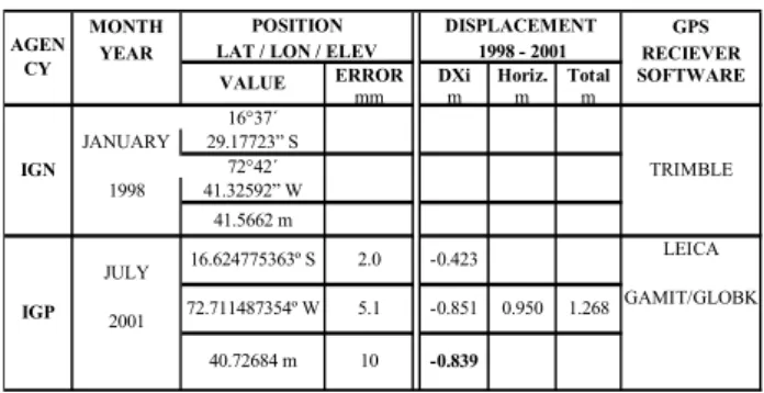
In July 2001, we reoccupied Caman´a and Ilo SIRGAS-GPS points with Leica SIRGAS-GPS double frequency receivers, for five continuous days, and sampling GPS data every 30 s. The field GPS data were processed with GAMIT/GLOBK soft-ware. The computed displacements are summarized in Ta-ble 1 for Caman´a point, and TaTa-ble 2 for Ilo point.
These results show that at Caman´a, the continental block was horizontally displaced 95 cm±0.6 cm in the N 244◦E di-rection and subsided 84 cm (Table 1, Fig. 2), and Ilo was displaced 41 cm±0.5 cm in the N 279◦E direction and sub-sided 16 cm (Table 2), i.e., Caman´a moved to the south west and Ilo to the west-northwest (Fig. 2). A simple dislocation simulation, using Harvard’s focal mechanism and Mansinha and Smylie’s (1971) algorithms, gives the following
theo-Table 1. Episodic displacement at SIRGAS-GPS Caman´a point. WGS84 Elipsoid. 23-June-2001 Arequipa earthquake.
± ± Table 1. q p q MONTH GPS YEAR RECIEVER
ERROR DXi Horiz. Total SOFTWARE
mm m m m 16°37´ JANUARY 29.17723” S 72°42´ 1998 41.32592” W 41.5662 m LEICA JULY GAMIT/GLOBK 2001 40.72684 m 10 -0.839 IGP 2.0 -0.423 5.1 -0.851 0.950 16.624775363º S 72.711487354º W TRIMBLE IGN DISPLACEMENT 1998 - 2001 1.268 AGEN CY POSITION LAT / LON / ELEV
VALUE
Table 2. Episodic displacement at SIRGAS-GPS Ilo point. WGS84 Ellipsoid. 23-June-2001 Arequipa earthquake.
± ± lacement at SIRGAS-GPS
q p q
Table 2. Episodic displacement at SIRGAS-GPS
R ER ARE CA LOBK BLE MONTH GPS YEAR RECEIVER
ERROR DXi Horiz. Total SOFTWARE
mm m m m 17°38´ JANUARY 46.76794” S 71°20´ 1998 42.9616” W 46.6745 m LEICA JULY GAMIT/GLOBK 2001 IGP 1.9 +0.068 4.9 -0.409 0.415 71.345255563º W 17.646323773º S TRIMBLE IGN DISPLACEMENT 1998 - 2001 0.446 AGE NCY POSITION LAT / LON / ELEV
VALUE
46.5115 m 9.8 -0.163
retical subsidence values: 60 cm at Caman´a, 5 cm at Are-quipa CGPS station, and near cero at. Ilo. The AreAre-quipa Continuous GPS (CGPS) recording station, at ∼286 km ESE of IGP’s epicenter and 163 km NE from HRV epicentroid, showed, since 1998, no significant episodic change in the deformation trend on any of the three geocentric coordi-nates prior to the June-23-2001-earthquake. The coseismic displacement of Arequipa-GPS site, according to Ruegg et al. (2001), was 0.43±0.05 m west, 0.27±0.02 m south, i.e., 51 cm total horizontal displacement. The vertical component displacement was “not seen because of the lesser precision of the altimetric determination due to tropospheric perturba-tions in the electromagnetic propagation of the GPS signal.” (Ruegg et al., 2001, p. 674). The Arequipa-GPS-horizontal-displacement vector has an azimuth N 238◦E. The Ilo and
the Arequipa horizontal displacement vectors converge near the epicentroid area; however, the Ilo and the Caman´a vec-tors converge farther west, near the Peru-Chile trench axis (Fig. 2).
Based on the Arequipa-CGPS station temporal behavior pre-June-23-earthquake, it is reasonable to assume that dis-placements determined at the Caman´a- and Ilo-GPS stations were produced by the June-23-2001-earthquake as a coseis-mic displacement. The horizontal displacement of Caman´a and Ilo and the subsidence affected the sea level and the shoreline position.
82 L. Ocola: Southern Per´u coseismic subsidence: 23 June 2001 8.4-Mw earthquake The Caman´a and Ilo subsidence is in accord with the 15 cm
subsidence of Matarani tide gauge (mareograph) determined by Koshimura and Sato (2005) from the hourly averages of the Matarani analog record (mareogram) before and after June-23-2001-earthquake. The GPS data and the Matarani tide gauge coseismic subsidence data are shown in Fig. 2.
The continental subsidence in Caman´a region along the coastal area can be observed as an apparent sea level rise and shoreline retreat. This fact is evident in the Caman´a seashore resort area, e.g., Cerrillos beach , where 200–300 m land re-mains under water after the earthquake – former Panamito Restaurant and nearby summer huts (GPS WGS84 coordi-nates: 16◦ 39.52′S latitude, 72◦ 38.60′W longitude). Sea
waves can be observed post-earthquake from the Gallinazos farm (Caman´a Delta), they were not possible to be seen be-fore the earthquake.
The observed coastal permanent subsidence produced by the 23-June-2001-earthquake in southern Per´u is at vari-ance with the permanent coastal uplift produced by the 12-November-1996 Nazca earthquake (Harvard Centroid: 15.040◦S latitude, 75.370◦W longitude, 37.4 km depth, 7.7 Mw magnitude). Ocola et al. (2006) report a coastal per-manent uplift ∼70 cm, estimated from the position of the pre-seismic sea-level mark on coastal cliffs at the epicentral area. The Nazca centroid is located close to the coastal line, and the ruptured block is in a zone where the Nazca Ridge meets the South American continent.
Neotectonic studies of southern Per´u showed that the coastal tectonic block southeast of the Nazca Ridge has un-dergone a secular uplift (Machar´e and Leureyro, 1991) dur-ing neoctectonic times. This implies that the accumulated interseismic secular coastal uplift is greater than the accumu-lated episodic coseismic subsidence produced by large earth-quakes, like the one of 23-June-2001.
4 Discussion
The coincidence of the 23-June-2001-earthquake rupture area surface projection with the Arequipa upper-slope sed-imentary basin is extraordinary. The rupture stopped at the transverse gravity and magnetic local-high anomalies near Ilo, just in the seawards extension of the continental Chololo fault system near Ilo. The strike of this fault system is ap-proximately normal to the Per´u-Chile trench. This relation-ship is in accord with the strong correlation between trench-parallel gravity anomalies and location of areas experiencing large coseismic slip reported by Song and Simons (2003).
The 23-June-2001-earthquake filled the NW area of the 1868-seismic gap. This gap has been recognized interna-tionally as a region of high potential for a large magnitude earthquake since the decade of the seventies. In 1978, the International Association for Earthquake Engineering held an International Workshop on Strong Motion Earthquake Instrument Array in Honolulu, Hawaii, and recommended,
among other things, that “Earthquake-threatened countries individually and collectively initiate the immediate installa-tion of minimal arrays of 10–20 strong-moinstalla-tion instruments at least at the 28 world-wide sites identified by this workshop” (Iwan, 1978, p. ix); and “A mobile strong-motion instrument array capable of making source mechanism, wave propaga-tion and local effects measurements be established and main-tained for deployment immediately following the occurrence of a major earthquake for recording of aftershocks” (Iwan, 1978, p. ix). Among the world‘s 28 promising locations for the strong-motion arrays were: 1) Ica (Per´u), in recog-nition of a seismic gap after the 1948 earthquake. This gap was filled by the 1996 Nazca Earthquake, 2) Arica (Chile) for the 1868 seismic gap, 3) Per´u: Cordillera (Mobile ar-ray site) to document shallow continental earthquakes, like 1950 Cusco, 1946 Quiches, 1960 Arequipa, etc. earthquakes (Iwan, 1978). Unfortunately, none of these arrays had been implemented and very valuable data were lost.
One of the last comprehensive seismic potential assess-ments of the Pacific Ocean rim was done by Nishenko (1985). Due to the lack of information, the level of proba-bilities of large earthquakes in the following decades ranged from 20–90%. It depends on the king of probability distribu-tion used to describe the seismic process. The SNAPP results showed no horizontal velocity of deformation anomaly in 1998. However, the vertical component did show an anomaly in land projection of the rupture area of the 23-June-2001 earthquake (Ocola, 2001).
From the point of view of prevention and mitigation of tsunamis disasters, the protective function of the marine bar-rier against the violence of the tsunami impact was one of the most important observed features of the 23-June-2001-earthquake. The barrier prevented the tsunami inundation reach the Caman´a City itself, and diminished the violence of the impact of the rushing up tsunami waves in the Caman´a Delta Front, the Caman´a River and part of the Puchchun farming area, prevented ground erosion, etc. On the other hand, the tsunami impact was very destructive in the Ca-man´a summer resort area at the southeast of the CaCa-man´a Delta, where there was no marine barrier. However, due to the coseismic subsidence of the continent, the barrier alti-tude, with respect to mean sea level, is lower now than it was before the 23-June-2001-earthquake. As a consequence, the Caman´a City vulnerability to future tsunamis has been increased; hence the disaster risk potential of the city of Ca-man´a due to tsunamis is higher now than it was before the 23-June-2001-earthquake.
The coseismic displacement of Caman´a and Ilo SIRGAS monuments documents the need to reoccupy SIRGAS mon-uments in and around the epicentral area immediately after the occurrence of a moderate-large earthquake, in order to as-sess changes in the national-geodetic-reference-frame mon-ument’s coordinates. However, it is important to recognize that the recovery to the preseismic secular velocity change in the monument’s position takes some time. There is no
experience about how long a time takes the recovery of the pre-seismic steady state of the deformation process. Con-tinuous permanent GPS stations in the epicentral area can provide such key information. Thus, to reduce any post-seismic geodetic position determination to the current geode-tic epoch, for each SIRGAS monument, besides the position and secular velocity change of the coordinates, it needs to be specified the episodic deformation due to earthquakes.
5 Conclusions
The rupture zone of the 23-June-2001 earthquake falls under the Arequipa upper slope sedimentary basin. The earthquake rupture propagated toward the SE and stopped near the SE gravity and magnetic anomaly highs in the transition zone of the Arequipa-Arica sedimentary basins, offshore Ilo.
The southern Per´u coastal region underwent a coseismic subsidence during the 23-June-earthquake, with maximum amplitude in the Caman´a region. The Arequipa and Ilo hor-izontal displacement converge toward the Harvard’s epicen-troid region. The Caman´a and Ilo horizontal displacement vectors converge to a zone near the trench. The Arequipa and Caman´a vectors do no intersect.
The pattern of displacement of the June-23-2001 earth-quake seems to be bimodal: Rebound and convergence to-ward the epicentroid in the southeast of Caman´a (flow type of motion) and rebound in the northwest. This pattern of displacement is at variance with the coseismic displacement determined for the Nazca-1996 earthquake, which shows re-bound and a clockwise rotation pattern.
This paper reports, for the first time, a coseismic displace-ment of SIRGAS monudisplace-ments, and points out to the need of resurveying all SIRGAS monuments after the occurrence of moderate or greater earthquakes, to provide reliable informa-tion for reducinforma-tion of topographic and geodetic surveys to the official reference “Epoch”.
Acknowledgements. The author would like to thank P. Fabian
and two anonymous referees for their constructive comments and suggestions.
Edited by: P. Fabian
Reviewed by: two anonymous referees
References
Chase Th. E.: Sea floor topography of the central eastern Pacific Ocean. U.S. Department of Interior. U.S. Fish and Wildlife Ser-vice. Bureau of Commercial Fisheries. Circular 29, Washington D.C., 1968.
Couch, R. and Whitsett, R. M.: Structure of the Nazca Ridge and the continental shelf and slope of southern Peru, Geol. Soc Ame. Memoir, 154, 569–586, 1981.
Coulbourn, W. T.: Tectonics of the Nazca plate and the continen-tal margin of western South America, 18◦S to 23◦S, Geol. Soc Ame. Memoir, 154, 587–618, 1981.
Fortes, P., Lauria, E., Brunini, C., Amaya, W., S´anchez, L., Drewes, H., and Seem´uller, W.: Current Status and Future Develop-ments of the SIRGAS Project, http://www.ife.uni-hannover.de/ milarbeiter/seeber/seeber 65/pdf 65/fort6.pdf, 2007.
Iwan, W. D. (Ed.): Strong-motion earthquake instrument ar-rays. Proceedings of the International Workshop on Strong-Motion Earthquake Instrument Arrays, 2–5 May 1978, Honolulu, Hawaii, California Institute of Technology, Pasadena California, USA, 103 pp., 1978.
Johnson, S. H. and Ness, G.: Shallow structure of the Per´u Margin 12◦S–18◦S, Geol. Soc Ame. Memoir, 154, 525–544, 1981. Koshimura, S. and Sato, H.: 6. Tsunami (PDF 357 kB), http://www.
jsceorjp/report/14/02/normal/Peru%20Ch6.1.pdf, 2005. Kulm La Verne, D., Dymond, J., Dasch, E. J., Hussong, D. M.
(Eds.): Nazca Plate: Crustal Formation and the Andean Con-vergence, Geol. Soc. Ame. Memoir, 154, 824 pp., 1981. Machar´e, J. and Leureyro, J.: Mapa Neotectonico del Per´u
(Actual-izaci´on), Instituto Geof´ısico del Per´u, Lima, Per´u, 1991. Manshinha, L. and Smylie, D.: The displacement field of inclined
faults, B. Seismol. Soc. Am., 61(5), 1433–1440, 1971.
NEIC: http://earthquake.usgs.gov/regional/neic, Moment tensor and broadband source parameter search, 2005.
Nishenko, S. P.: Seismic potential for large and great interplate earthquakes along the Chilean and southern Peruvian margins of South America: a quantitative reappraisal, J. Geophys. Res., 90, 3589–3615, 1985.
Norabuena, E., Leffler-Griffin, L., Mao, A., Dixon, T., Stein, S., Sacks, I. S., Ocola, L., and Ellis, M.: Space geodetic obser-vations of Nazca-South America convergence across the central Andes, Science, 279, 358–362, 1998.
Norabuena, E. and Ocola, L.: Desplazamientos Est´aticos Asociados al Terremoto de Nazca de Noviembre 12, 1996, www.igp.gob.pe, 2000.
Ocola, L.: Precursory hints of June 23-2001 earthquake in southern Per´u seismic gap, American Geophysical Union Fall Meeting, Proceedings, San Francisco, California, USA, 2001.
Ocola, L., Monge, F., Huaco, P., Ag¨uero, C., and Fern´andez, E.: El terremoto de Nazca de 1996: Intensidades macros´ısmicas y efec-tos geol´ogicos. XII Congreso Peruano de Geolog´ıa, Res´umenes Extendidos, Sociedad Geol´ogica del Per´u, Lima, Per´u, 397–400, 2006.
Ruegg, J. C., Olcay, M., and Lazo, D.: Co- post – and Pre(¿)-seismic Displacements Associated with the Mw 8.4 Southern Per´u Earthquake of 23 June 2001 from Continuous GPS Mea-surements, Seis. Res. Lett., 72(6), 673–678, 2001.
Song, T.-R. A. and Simmons, M.: Large Trench-Parallel Gravity Variations Predict Seismogenic Behavior in subduction Zones, Science, 301, 630–633, 2003.
Tavera, H., Fern´andez, E., Bernal, I., Antayhua, Y., Ag¨uero, C., Salas, H., Rodr´ıguez, S., Vilcapoma, L., Zamudio, Y., Portugal, D., Inza, A., Carpio, J., Ccallo, F., and Valdivia, I.: The south-ern region of Peru earthquake of June 23rd, 2001, J. Seismol., reprint, 2006.