HAL Id: hal-00296852
https://hal.archives-ouvertes.fr/hal-00296852
Submitted on 2 May 2005
HAL is a multi-disciplinary open access
archive for the deposit and dissemination of
sci-entific research documents, whether they are
pub-lished or not. The documents may come from
teaching and research institutions in France or
abroad, or from public or private research centers.
L’archive ouverte pluridisciplinaire HAL, est
destinée au dépôt et à la diffusion de documents
scientifiques de niveau recherche, publiés ou non,
émanant des établissements d’enseignement et de
recherche français ou étrangers, des laboratoires
publics ou privés.
Extreme flash floods in Barcelona County
A. Barrera, M. Barriendos, M. C. Llasat
To cite this version:
A. Barrera, M. Barriendos, M. C. Llasat. Extreme flash floods in Barcelona County. Advances in
Geosciences, European Geosciences Union, 2005, 2, pp.111-116. �hal-00296852�
SRef-ID: 1680-7359/adgeo/2005-2-111 European Geosciences Union
© 2005 Author(s). This work is licensed under a Creative Commons License.
Advances in
Geosciences
Extreme flash floods in Barcelona County
A. Barrera, M. Barriendos, and M. C. LlasatMeteorological Hazards Analysis Team (GAMA), Department of Astronomy & Meteorology, Faculty of Physics, University of Barcelona, Av. Diagonal 647, E-08028 Barcelona, Spain
Received: 24 October 2004 – Revised: 18 March 2005 – Accepted: 21 March 2005 – Published: 2 May 2005
Abstract. In this paper the catastrophic and extraordinary floods occurring in Barcelona County (Catalonia, NE Spain) are studied, in order to characterise the temporal evolution of extreme flash floods in that area and their main features. These events usually cause economical losses and major problems for undertaking daily activity in Barcelona city. This kind of floods is a very common feature in the North-east of Spain and they are recorded every year in some point of Catalonia. This contribution also shows the frequency of those events, within the framework of all the floods that have occurred in Barcelona since the 14th century, but also de-scribes the flooded area, urban evolution, impacts and the weather conditions for any of most severe events. The evo-lution of flood occurrence shows the existence of oscillations in the earlier and later modern age periods that can be at-tributed to climatic variability, evolution of the perception threshold and changes in vulnerability. A great increase of vulnerability can be assumed for the period 1850–1900. The analysis of the time evolution for the Barcelona rainfall series (1854–2000) shows that no trend exists, although, due to the changes in urban planning, flash-floods impact has changed over this time. The number of catastrophic flash floods has diminished, although the extraordinary ones have increased.
1 Introduction
Flash floods are a very common feature in the North-east of Spain. Every year, during the summer or at the beginning of autumn, this kind of floods affects the littoral mountains or the Pyrenees region. Sometimes they can also occur in spring (Llasat et al., 2003). Usually the maximum accumulated rainfall is less than 100 mm, with instantaneous intensities above 3 mm/min. They are associated with convective events for which more than 30% of the accumulated rainfall has an intensity of above 35 mm/h. On some occasions, this per-Correspondence to: A. Barrera
centage surpasses 80%, although these are very brief events (Llasat, 2001). Sometimes, however, more than 250 mm can be recorded in 3 h. Depending on orography, human settle-ments and other factors, flash floods can produce catastrophic impacts. This was the case of the events of 5 September 1389, 8 April 1794, 14 September 1862, 21 September 1995 or 31 July 2002. Research into historical climatology shows this constitutes natural behaviour in this region, despite natu-ral climatic variability, although flood impacts have evolved over time.
The main objectives of this paper are: 1) identification and classification of historical floods, and characterisation of flash-floods among historical floods for Barcelona county, reviewing prior works concerning this topic (Barriendos and Mart´ın-Vide, 1997 and 1998) and developing more accurate information, basically for the last 150 years, 2) identifica-tion of meteorological trends that could explain the historical evolution of flood occurrence, especially for the 1850–2000 period for which continuous rainfall data series exist, and 3) identification of the influence of urban development on the vulnerability to floods.
The paper deals with the evolution of flash floods in Barcelona county since the Roman Epoch (although flood data are only available since the 14th century) down to the present day, taking account of the changes that have occurred in the water courses and in urbanization. First of all, the ge-ographic and historical evolutions are presented. Once the flash flood events and their attendant damage have been iden-tified, the main climatological features are discussed. Floods that have occurred in other basins have been also considered. Finally, some flash-flood events are presented in order to show the different patterns of human response to those haz-ards: a) human settlement that take account of natural con-ditions; b) structural protections (walled perimeters with hy-draulic functions); c) living with the natural conditions with-out taking account of the phenomena (urban growth with no planning or precautions); d) non-obstructive structural works (drainage networks and underground water reservoirs to reg-ulate overflowing).
112 A. Barrera et al.: Extreme flash floods in Barcelona County
First Urbanized area Coastal lagoon Be sòs Rive r L lob reg at R ive r 0 1 2 km N
Mediterranean S
ea
Collserola Range
Barcelona
Fig. 1. Water courses in Barcelona county under natural con-ditions. Data obtained from Casassas i Sim´o (1984), Granados (1984), Oliv´e i Guilera (1993), Riba i Arderiu (1993), Sanz-Parera (1988), Travesset-Queralt´o (1994) and Vila (1974). Urbanized area corresponds to period 200 BC–AD 1250.
2 Geography of Barcelona County and its historical
evolution
The city of Barcelona (NE Spain) is situated in a Quaternary plain between two rivers, the Llobregat River to the SW and the Bes`os River to the NE. The plain is delimited by the coast and the Collserola range (Palaeozoic formation), with
max-imum altitudes around 500 m, and with an area of 120 km2.
Twelve short water courses (ouadis), with a strong slope and non-permanent flow, traverse this plain in parallel (Fig. 1). When heavy rains or a long rainy period arise over or near the city, their overflowing can produce significant damage, and floods, landslides and temporary lagoons can be recorded. Nowadays, most of these water courses are channelled and they belong to Barcelona’s drainage system, with most of them interconnected. This network has been improved in re-cent years with the construction of underground water reser-voirs into the city. As a consequence, heavy rainfall effects over the city are not the same as in the past.
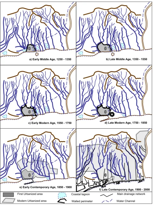
Barcelona city has had a complex but interesting historical evolution. The relationship between human occupation and environmental conditions generates most definitive urban configurations and location of infrastructures. There never-theless exists no clear perception of this evolution, flood risk and different mitigating strategies as key factors considered by authorities in managing urban planning. An overview can offer interesting experiences and coexistence patterns. The evolution of Barcelona city, from a consideration of flood risk criteria, can be defined in seven different stages:
a) BC 200–AD 1250: Throughout the presence of the Ro-man Empire, practically natural conditions remained. Taber hill (16 m a.s.l.) was used for human occupation,
thereby avoiding flood risk. Barcino was a small city surrounded by littoral lagoons fed by small temporary rivers (Fig. 1).
b) 1250–1350: The Early Middle Age experiences the first flood risk assumptions, occupying temporarily flooded areas and littoral lagoons. An opened walled perimeter was designed with military function, but also to manage the floods, diverting flows out of the urbanized quar-ters. Unfortunately, no systematic documentary sources are available for this period. Flood events were not yet recorded (Fig. 2a).
c) 1350–1550: The Late Middle Age brought urban
growth, generating a third walled perimeter. This re-newed powerful infrastructure drove water flows into trenches. Flood events were recorded, but most of the damage occurred in this first infrastructure or in at the outlet from trenches, close to littoral lagoons. This plan-ning strategy allowed, albeit with limited technology, an evident reduction of impacts caused by flooding in the urbanized sector of the city (Fig. 2b).
d) 1550–1750: The Early Modern Age brought a nega-tive factor for flood situation managing. The presence of Turkish pirates in the Mediterranean Sea rendered necessary the construction of a “Sea Wall”, enclosing the city completely, because dynamic defence with gal-leys was unsuccessful. Large rainfall events produc-ing floods were managed by combination of walls and trenches with relatively good results. Problems arose with flash floods, when torrential rainfall was recorded into the city itself: a new dam effect was produced by the “Sea Wall” because of drainage limitation (Fig. 2c). e) 1750–1850: Late Modern Age. The only important changes affected the eastern area, with the construction of a new fortress. The last remaining coastal lagoons disappeared. Fluvial processes did not change in rela-tion to the previous pattern (Fig. 2d).
f) 1850–1900: Early Contemporary Age. During this
short period, the traditional protection of walled perime-ter was removed, but was replaced by other operative infrastructure to manage flood events. Barcelona, with one of the highest human density levels of its history, experienced a return to natural conditions. Most of non-permanent rivers recover their ancient beds into or close to the city (Fig. 2e).
g) 1900–21st century: A new period of flood risk manage-ment started with the drainage network programme of 1890. Following different steps, during this century a new fluvial system was organized at underground lev-els, including pumping stations, water reservoirs and a warning system, to manage the flood events affecting the more vulnerable human activities (Fig. 2f).
First Urbanized area Coastal lagoon
Walled perimeter Water Channel Modern Urbanized area
Main drainage network
b) Late Middle Age, 1350 - 1550
c) Early Modern Age, 1550 - 1750 d) Late Modern Age, 1750 - 1850
f) Late Contemporary Age, 1900 - 2000 e) Early Contemporary Age, 1850 - 1900
a) Early Middle Age, 1250 - 1350
Fig. 2. Barcelona city urban evolution from the 14th century to the present: (a) AD 1250–1350; (b) AD 1350–1550; (c) AD 1550–1750; (d)
AD 1750–1850; (e) AD 1850–1900; (f) AD 1900–2000.
3 History of floods in the Barcelona county: occurrence
and impacts
In order to organise historical information in conjunction with modern data a common criterion to classify flood events has been used. This criterion distinguishes between “ordi-nary” (flood without overflow and without material damage), “extraordinary” (overflow with damage), and “catastrophic” (overflow with destruction). More information about this methodology and other criteria to classify historical floods can be found in Barriendos and Llasat (2003a), Barriendos et al. (2003b, 2003c), Lang et al. (1998). A flood can be considered as a flash flood taking account rainfall duration (some hours) and the response speed of the basin. For the
most recent cases, the rainfall intensity has been also taken into account. A first proposal of flash floods for small basins like Barcelona county might consist in sudden floods pro-duced by an intense rainfall event which lasts less than 6 h and accumulates more than 50 mm within this period.
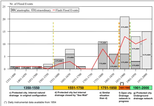
In Barcelona, reconstruction of historical flood chronolo-gies for the past 650 years has allowed the identification of 40 catastrophic floods and 44 extraordinary floods since 1351, 64% of which could be considered flash floods. Seasonal distribution shows that autumn, followed by summer, is the season with the highest number of floods, and September (29 cases), followed by October (20 cases), as the month with the highest record. September also shows the greatest number of flash floods, with 83% of the monthly total.
114 A. Barrera et al.: Extreme flash floods in Barcelona County
1350-1550 1551-1750 1751-1850 1851-1900
c) Protected city. Internal natural drainage in original configuration
d) Protected city but internal drainage closed by “Sea Wall”
e) Similar situation than d) f) Open city. Drainage network in progress 1901-2000 g) Protected city. Underground drainage network (*)
(*): Daily instrumental data available from 1854
1351 -14 00 1401 -145 0 1451 -150 0 1501 -155 0 1551 -160 0 1601 -165 0 1651 -170 0 1701 -175 0 1751 -180 0 1801 -185 0 1851 -190 0 1901 -195 0 1951 -200 0 0 5 10 15 20 25 Nr. of Flood Events
Catastrophic Extraordinary Flash Flood Events
1 FLASH 1 FLASH 1 FLASH
2 FLASH 3 FLASH 7 FLASH 1 FLASH 2 FLASH 8 FLASH 5 FLASH 8 FLASH 2 FLASH 12 FLASH
Fig. 3. 50-year period flood distribution in Barcelona county from AD 1351 to 2000.
Figure 3 shows the number of floods recorded from 1351 until 2000, for 50-year periods. The number of flash floods for each period is also included. Catastrophic events affect the city in spite of protection efforts. The record of their im-pacts shows the chronology of natural phenomena produc-ing severe floods. This figure provides information on the evolution of flood occurrence in relation to meteorology and on the evolution of vulnerability. Climatic oscillations can be observed in the early and late modern age periods: some periods that last 40 years show an increasing frequency of events (i.e. 1580–1620, 1760–1800), while other longer pe-riods show a lower occurrence of floods (1660–1760). This kind of variability is also observed for the entire Catalonia region (Barriendos and Llasat, 2003a). Besides this, the evo-lution of flood occurrence shows an increase of extraordinary events in conjunction with an increase of flash flood events over the last 150 years.
After five centuries of relatively low vulnerability, in which only extreme events affected the city but destroyed external walls, Barcelona experienced a short period of 50 years (1851–1900) with an abrupt increase of vulnerability (Fig. 3). Really, it was a human collective decision, prefer-ring rapid and complete destruction of the walled perimeter before the planning and construction of pertinent networks for different services including drainage had been addressed. The increase of extraordinary events, practically unknown during Middle and Modern Ages, was simply the result of the abrupt change of environmental conditions: a 19th cen-tury industrial city was converted over the course of 50 years back to natural conditions like those of 2000 years earlier. A comment should be added on the evolution of the perception threshold by society. It might be observed that the few events documented in the Middle Ages period could be attributed to
a higher perception threshold (probably only the main catas-trophic events are documented in archives).
From a human perspective, people did not retain any mem-ory of such frequent flood events. Then, the reaction was positive but planning and implementation of infrastructures to diminish vulnerability took several decades. Meanwhile, Barcelona is an excellent field of research into how flash floods affected an urbanized area: local newspapers describe all hydrologic aspects and damages.
On the other hand, Barcelona has the oldest daily pre-cipitation series on the Spanish Mediterranean coast (1854– 2000). Then, a climatic approach from instrumental data since the 19th century can also be made. Besides the rain-fall features of each event, the main climatic aspects of the daily precipitation in Barcelona and its possible relation-ship with an increase or decrease of flood number are anal-ysed. The total number of days with appreciable precipi-tation (≥0.1 mm) is 10 610 (20% of days). These days are distributed as follows: 81% days with ≥1 mm; 5.3% days with ≥30 mm; 1.6% days with ≥50 mm and 0.1% days with
≥100 mm. There is no day with ≥200 mm. The threshold of
50 mm/day was considered in order to look systematically for flood events in the city for the period 1854–2000. This value coincides with the mean monthly rainfall, and has an average frequency of 1 case per year. The evolution of monthly maxi-mum daily precipitation shows no important trend; therefore, extreme precipitation has not been increasing.
4 Comparative study of impacts
In this paragraph, an example of flash flood for each pe-riod has been considered. Documentary testimonies for each
flood event show different meteorological and impact as-pects.
4.1 The Late Middle Age: The catastrophic flash flood of 5
September 1389
Contemporaneous testimonies show that walled perimeter had a function of city protection and management of river floods, diverting the flow to the sea around the perimeter. But the energy of the flash floods proved excessive for build-ings close to the wall in the sector where rivers beds were intercepted by walls (especially St. Peter Quarter). Torren-tial rainfall for only 3 h was enough to bring down buildings. But the worst impact in a pre-industrial society was outside the city: water channels feeding water mills would remain out of service for two weeks. The city could not produce flour, and shortages and famine appeared temporarily.
4.2 The Early Modern Age: The catastrophic flash flood of
28 October 1591
This event is a typical example of torrential rainfall affect-ing of the Barcelona hinterland. Rivers overflowed with high energy against the walled perimeter. Urbanized sectors did not record damage, but various installations of the walled perimeter were destroyed (two bastions). The authorities deemed this damage acceptable, for the flooding did not pro-duce casualties or other damage to productive activities.
4.3 The Late Modern Age: The catastrophic flash flood of
8 April 1794
This event only shows peculiarities close to the new fortress. The main water channel of the city contributed to flood events by bringing into this sector the overflow from the River Bes`os. Without slope towards the sea, water reaching this sector produced floods in a dense urban area.
4.4 The Early Contemporary Age: The catastrophic flash
flood of 14 September 1862
This is an example of extreme events with no protection. For-tunately the water did not have sufficient energy to destroy infrastructures and buildings, but in low parts of the city the flood had a magnitude unknown in previous centuries. Con-temporary descriptions depict the city like a sea with only Taber hill free from flooding.
4.5 The Late Contemporary Age: The extraordinary flash
flood of 21 September 1995 and ordinary flash flood of 31 July 2002
These are two examples of the efficiency of drainage infras-tructures to reduce and mitigate the flood impacts of those events with high intensities and amounts of precipitation in the city. The September case turned a lot of streets into rivers, and the low part of the city, where the littoral lagoons ex-isted in the past, were flooded due to high rainfall of 145 mm
in less than 45 min. This is a typical case of a flash flood produced by a sudden thunderstorm that the meteorological models did not forecast. This event spurred the construction of underground water reservoirs to provide better drainage. The July case only produced localised problems in the city despite more than 100 mm being recorded in less than 3 h. This flash flood was produced by a thunderstorm that devel-oped into a convective system that affected the Central coast of Catalonia. The first one could have produced catastrophic damages without a good drainage system and the second one, extraordinary effects in Barcelona city were it not for the wa-ter reservoirs.
5 Conclusions
The evolution of flood occurrence in Barcelona county, from 14th century until the present day, shows the existence of climatic oscillations in the early and late modern age peri-ods, like 1580–1620, 1760–1800 and 1660–1760, and some trends that could be mainly related with climatic variabil-ity. The absence of trend in rainfall series from 1854 can-not explain the increased number of events over the last 150 years. Such a trend observed in the number of floods docu-mented can be mainly attributed to evolution of the percep-tion threshold and changes in the vulnerability from the mid-dle of the 19th century. A great increase of the vulnerability can be assumed from 1850, and this vulnerability progres-sively decreases through to 2000, considering that there was no significant trend in the rainfall series from 1854 to 2000.
The previous study has allowed three objectives to be at-tained. The first was to advance towards a general definition of flash floods in the Western Mediterranean area, for which no such definition exists. A first proposal could be sudden floods produced by an intense rainfall event which lasts for less than 6 h and accumulates more than 50 mm in this pe-riod; however, further studies are needed for other places along the Mediterranean coast. Secondly, the analysis of the time evolution for rainfall shows that no trend exists. How-ever, due to the changes in urban planning, flash flood im-pact has changed over time. As a consequence, the number of catastrophic flash floods has diminished, although the ex-traordinary ones have increased. This fact is related with the third objective, which is to note the mitigation of flood im-pacts if a good drainage system is developed. The 1850–1900 period is an example of poor management and planning.
Acknowledgements. The authors thank the RAMSHES
(REN2002-04584/CLI) Spanish project, the AMPHORE (Interreg IIIB MEDOCC 2003-03-4.3-I-079) European project and “Ram´on y Cajal” Programme (Spanish Ministry of Education and Science) for enabling the drawing up of this paper. Our thanks also to the two anonymous referees of this paper for their interesting suggestions and comments.
Edited by: L. Ferraris
116 A. Barrera et al.: Extreme flash floods in Barcelona County References
Barriendos, M. and Mart´ın-Vide, J.: Meteorological hazards in Barcelona as from historical records (from the 14th to the 19th century), Initial results concerning their plurisecular climatic pat-tern, in: Advances in Historical Climatology in Spain, edited by: Mart´ın-Vide, J., Oikos-Tau, Barcelona, 133–156, 1997. Barriendos, M. and Mart´ın-Vide, J.: Secular climatic cscillations
as indicated by catastrophic floods in the Spanish Mediterranean coastal area (14th–19th Centuries), Climatic Change, 38, 473– 491, 1998.
Barriendos, M. and Llasat, M. C.: The case of the “Mald´a” Anomaly in the Western Mediterranean basin (AD 1760–1800): An example of a strong climatic variability, Climatic Change, 61(1), 191–216, 2003a.
Barriendos, M., Llasat, M. C., Barrera, A., and Rigo, T.: The study of flood events from documentary sources. Methodological guidelines for historical sources identification and flood charac-terization in the Iberian peninsula, in: Palaeofloods, Historical Floods and Climatic Variability: Applications in Flood Risk As-sessment, edited by: Thorndycraft, V. R., Benito, G., Barriendos, M., and Llasat, M. C., (Proceedings of the PHEFRA Workshop, Barcelona, Spain, 16–19th October, 2002), CSIC, Madrid, 87– 92, 2003b.
Barriendos, M., Coeur, D., Lang, M., Llasat, M. C., Naulet, R., Lemaitre, F., and Barrera, A.: Stationarity analysis of historical flood in France and Spain (14th–20th centuries), Nat. Haz. Earth Sys. Sci., 3, 583–592, 2003c,
SRef-ID: 1684-9981/nhess/2003-3-583.
Casassas i Sim´o, L.: El Barcelon`es, La hidrologia del pla de Barcelona, Gran geografia comarcal de Catalunya, 8, 16–20, 1984.
Granados, O.: El Barcelon`es. La hist`oria, Gran geografia comarcal de Catalunya, 8, 40–48, 1984.
Lang, M., Coeur, D., Lallement, C., and Naulet, R. : Valorisation de l’information historique pour la pr´ed´etermination du risque d’inondation: application au basin du Guiers, Ing´enieries EAT, 16, 3–13, 1998.
Llasat, M. C.: An objective classification of rainfall events on the basis of their convective features. Application to rainfall intensity in the North-East of Spain, International Journal of Climatology, 21, 385–1400, 2001.
Llasat, M. C., Rigo T., and Barriendos, M.: The “Montserrat-2000” flash flood event: a comparison with the floods that have occurred in the northeastern Iberian Peninsula since the 14th century, In-ternational Journal of Climatology, 23, 453–469, 2003. Oliv´e i Guilera, J.: Les rieres del pla de Barcelona a mitjan segle
XIX, Proceedings del III Congr´es d’hist`oria de Barcelona, 2, 399–408, 1993.
Riba i Arderiu, O.: Assaig sobre la geomorfologia medieval de la ciutat vella de Barcelona, Proceedings del III Congr´es d’hist`oria de Barcelona, 1, 171–176, 1993.
Sanz-Parera, M.: El pla de Barcelona: constituci´o i caracterstiques f´ısiques, Els llibres de la Frontera, Sant Cugat del Vall`es, Col. “Coneguem Catalunya”, n. 25, 1988.
Travesset-Queralt´o, M.: La xarxa hidrogrfica del Pla de Barcelona entre la riera de Mag`oria i la riera d’Horta, Finestrelles, 6, 57–70, 1994.
Vila, P.: El Barcelon`es i Barcelona ciutat, Geografia de Catalunya, AEDOS, 3, 497–608, 1974.