ADS-‐B
B
ENEFITS
T
O
G
ENERAL
A
VIATION
A
ND
B
ARRIERS
T
O IMPLEMENTATION
by
Fabrice Kunzi
B. Sc. Mechanical Engineering University of North Dakota, 2008
Submitted to the Department of Aeronautics & Astronautics in Partial Fulfillment of the Requirements for the Degrees of
Master of Science in Aeronautics and Astronautics at the
Massachusetts Institute of Technology
June 2011
© 2011 Massachusetts Institute of Technology. All rights reserved.
Author:
Department of Aeronautics & Astronautics May 20, 2011
Certified by:
R. John Hansman Professor of Aeronautics & Astronautics Thesis Supervisor
Accepted by:
Eytan H. Modiano Associate Professor of Aeronautics & Astronautics
A
BSTRACT
Automatic Dependent Surveillance -‐ Broadcast (ADS-‐B) will be the basis of the future surveillance system in the US. To achieve benefit from ADS-‐B, aircraft have to be equipped with ADS-‐B avionics across all stakeholders. General Aviation (GA) comprises over 96% of the active aircraft fleet in the US but average yearly utilization for GA aircraft is 21 times lower than that of commercial aircraft. Since many benefits from ADS-‐B depend on aircraft utilization, concern exists that ADS-‐B does not provide enough user benefit to GA, possibly resulting in delayed acceptance and aircraft equipage with ADS-‐B avionics.
One way of providing user benefits and thus increasing incentives for GA users to equip with ADS-‐B is to create and implement ADS-‐B applications that are of high value to those operators. ADS-‐B Surveillance in non-‐RADAR airspace and ADS-‐B based Traffic Situation Awareness (TSA) are identified as two applications that are expected to provide significant benefit to GA. Both applications are evaluated and possible barriers to the delivery of benefit are identified.
In order to identify where TSA would be most beneficial, ten years’ worth of NTSB mid-‐air collision reports were reviewed. Ten years of ASRS and NMACS near mid-‐air collision (MAC) reports were also reviewed. The analysis revealed that aircraft are most likely to encounter each other in the airport vicinity – specifically in the pattern (59% of MACs). Current Traffic Awareness systems are not reliable in that environment due to insufficient surveillance data quality. Surveillance data from ADS-‐B , however, has much higher resolution. Therefore, ADS-‐B based traffic alerting systems are expected to be capable of providing reliable alerting in such environments and would thus pose a significant incentive for GA to equip with ADS-‐B.
An analysis of the current availability of low altitude surveillance over the continental United States was conducted in order to identify where ADS-‐B Low Altitude Surveillance would be beneficial. Providing low altitude surveillance has the potential to improve efficiency during IFR conditions. 27 towered airports with RADAR floors of more than 500ft have been identified. ADS-‐B surveillance in those locations would create a significant benefit locally. Non-‐towered airports without low altitude surveillance are more common (806 total). ADS-‐B surveillance to such airports has the potential to increase airport acceptance rates in Instrument Flight weather and thus providing benefit to GA.
However, in addition to providing surveillance, additional ATC procedures need to be developed to take advantage of such ADS-‐B surveillance. The new procedures would allow ATC to remain in radio communication with aircraft operating at non-‐towered airports, preventing the application of inefficient procedural control.
A
CKNOWLEDGMENTS
I would like to express my sincere thanks to Prof. Hansman for his tireless support and instruction. His knowledge and insight have taught me much and have made me a better engineer.
I wish to thank Brooklyn Lowry for her support volunteering her editorial and journalistic skills.
My deepest thanks go to my wife and best friend Alyssa who has been my greatest supporter and motivator. Her caring and selfless attitude has let me work long nights to finish my work while still finding rest at home.
T
ABLE OF
C
ONTENTS
Chapter 1 Introduction and Motivation ... 13
Chapter 2 Overview of ADS-‐B System Architecture ... 17
2.1 Aircraft Capability – Aircraft Avionics ... 20
2.1.1 ADS-‐B Out Mandate ... 20
2.2 ADS-‐B Ground Infrastructure ... 21
2.3 ADS-‐B Operating Procedures ... 23
2.3.1 Adoption of Existing, RADAR Based Procedures ... 23
2.3.2 Introduction of New, ADS-‐B Specific Procedures ... 24
2.4 ADS-‐B Applications ... 24
2.4.1 ADS-‐B Out Applications ... 25
2.4.2 Data Link Applications: FIS-‐B and TIS-‐B ... 26
2.4.3 ADS-‐B In Applications ... 28
Chapter 3 ADS-‐B Avionics Architectures for General Aviation ... 31
3.1 Navigation Unit ... 32
3.1.1 GPS Integrity ... 34
3.1.2 GPS Accuracy ... 36
3.1.3 Common GPS systems used in GA ... 38
3.2 ADS-‐B Transceiver ... 38
3.2.1 Historical ADS-‐B Transceivers ... 39
3.3 Cockpit Displays for ADS-‐B In ... 40
3.4 Antennae ... 41
3.5 Upgrade Paths From Transponder Based Surveillance Systems ... 41
3.6 Certification of ADS-‐B Avionics Installations ... 43
Chapter 4 Identifying ADS-‐B User Benefits to General Aviation ... 45
4.1 ADS-‐B Benefit Categories ... 47
4.1.1 Improved Safety ... 47
4.1.3 Reduced Infrastructure and Maintenance Cost ... 48
4.2 Previous Work on GA User Benefits ... 50
4.2.1 Lester User Survey and User Benefit Mapping (Lester 2007) ... 50
4.2.2 AIWP Benefit/Application Ranking (FAA 2010) ... 52
4.3 High User Benefit Applications for GA ... 53
4.3.1 Safety Improvements From Data Link Applications ... 54
4.3.2 Applications That Improve Safety ... 54
4.3.3 Applications That Increase Efficiency ... 55
4.4 Conclusion ... 57
Chapter 5 Identification of High Benefit Environments For Traffic Situation Awareness Applications ... 59
5.1 Mid-‐Air Collision Analysis: NTSB Accident Reports ... 59
5.1.1 Mid-‐Air Collisions Reported in the Airport Pattern ... 61
5.1.2 Mid-‐Air Collisions Reported in the Airport Vicinity ... 62
5.1.3 Mid-‐Air Collisions Reported Away from the Airport ... 63
5.2 Near Mid-‐Air Collision Analysis: ASRS and NMACS Databases ... 64
5.3 Conclusion: ADS-‐B Based Traffic Situation Awareness Brings Major Benefit to GA .. 68
Chapter 6 Identification of High Benefit Locations For ADS-‐B Low Altitude Surveillance ... 71
6.1 Analysis of Existing RADAR Coverage Over the Contiguous United States ... 73
6.2 Identification of Airports Where ADS-‐B Surveillance Could Provide Benefit ... 76
6.3 ADS-‐B Efficiency Benefits at Towered Airports ... 77
6.4 ADS-‐B Efficiency Benefits at Non-‐Towered Airports ... 79
6.4.1 Non-‐Towered Airports With RADAR Floors in Excess of 1500ft AGL ... 80
6.5 Conclusion ... 82
Chapter 7 Summary and Conclusion ... 83
Full List of Required ADS-‐B Message Elements ... 85
Appendix A Detailed ADS-‐B Out Avionics Architectures ... 87
Appendix B Survey of Potential ADS-‐B Benefits to the Soaring Community ... 89
Appendix C Detailed Search and Rescue Process ... 93 Appendix D
List of Non-‐Towered Airports With More Than 10,000 Yearly Operations Appendix E
and a RADAR Floor In Excess of 1,500ft. ... 95
L
IST OF
F
IGURES
Number Page
Figure 1: Worldwide Status of ADS-‐B Implementation in March 2011 (FreeFlight
Systems 2009) ... 13
Figure 2: Comparison of General Aviation to Air Carrier Active Fleet. General Aviation Includes Air Taxi (BTS) ... 15
Figure 3: Average Yearly Hours Flown by General Aviation Aircraft compared to Air Carrier Aircraft (BTS) ... 15
Figure 4: Schematic Representation of Multi-‐Stakeholder Cost/Benefit Distribution (Adapted from Marais and Weigel 2007) ... 16
Figure 5: Schematic Representation of ADS-‐B ... 18
Figure 6: Cockpit Display of Traffic Information (CDTI) ... 18
Figure 7: Predicted ADS-‐B Coverage at Full Implementation ... 22
Figure 8: Temporary Installation of an ADS-‐B Antenna on a Terminal Area RADAR Tower in Brisbane, Australia (credit: Greg Dunstone) ... 22
Figure 9: FIS-‐B Information Displayed on MFD ... 28
Figure 10: Schematic Representation of an ADS-‐B Avionics Architecture ... 31
Figure 11: Schematic of Error Effects on GPS Signal ... 34
Figure 12: Effect of Satellite Constellation and Integrity Bounds on Position Accuracy ... 36
Figure 13: Schematic Representation of. 95% Position Accuracy of 1m (left) and 0.25m (right). True Position marked With Red Cross. ... 37
Figure 14: Upgrade Paths From Currently Required Equipment to UAT and 1090ES. ... 43
Figure 15: Example Disaggregate Cost Benefit Distribution Modified for ADS-‐B (adapted from (Marais and Weigel 2007)) ... 45
Figure 16: Multi-‐Stakeholder Cost Benefit Distribution Adopted for the FAA, Air Carrier and GA ... 46
Figure 17: ADS-‐B and RADAR Coverage in Australia at 10,000ft AGL (Air Services Australia 2011) ... 49
Figure 18: Results From Lester's User Survey ... 51
Figure 19: Predicted ADS-‐B Surveillance Coverage for the United States ... 56
Figure 21: Track Intersect Angle Summarized for All NTSB Mid-‐Air Collision Reports ... 61 Figure 22: Location Distribution and Geometry of All NTSB Mid-‐Air Collisions in the
Airport Pattern ... 62 Figure 23: Geometry Distribution for Encounters in the Vicinity of the Airport ... 62 Figure 24: Flight Phases of Mid-‐Air Collisions Away From the Airport ... 63 Figure 25: Track Intersect Angle for Mid-‐Air Collisions Away From the Airport With and
Without Formation Flights ... 64 Figure 26: Near Mid-‐Air Collisions Reported in the ASRS Database by Respective Flight
Phase. Encounters Along the Diagonal Are Between Aircraft in the Same Flight Phase. ... 65 Figure 27: Near Mid-‐Air Collisions Reported in the NMACs Database by Respective
Flight Phase. Encounters Along the Diagonal Are Between Aircraft in the Same Flight Phase. ... 66 Figure 28: Flight Phase And Altitude Distribution of GA/Part 121 Encounters in the
ASRS Database ... 67 Figure 29: Flight Phase And Altitude Distribution of GA/Part 121 Encounters in the
NMACS Database ... 68 Figure 30: Schematic Representation of Approach to an Airport Without RADAR
Surveillance to the Surface ... 72 Figure 31: Altitude of Lowest ETMS Track Over United States in 2004-‐2005 ... 74 Figure 32: Altitude of Lowest ETMS Track Above Ground Level Over US in 2004-‐2005
And Airports With At least 10,000 Yearly Operations ... 75 Figure 33: Altitude Distribution of Lowest ETMS Track Above All Public US Airports
(AGL) ... 76 Figure 34: Altitude Distribution of Lowest ETMS Track Above US Airports (AGL) With
More Than 10,000 Yearly Operations ... 77 Figure 35: Towered Airports With Observed RADAR Floors of More Than 500ft ... 78 Figure 36: Non-‐Towered Airports With More Than 10,000 Yearly Operations and an
Observed RADAR Floor Higher Than 500ft AGL ... 79 Figure 37: Number of Non-‐Towered Airports With More Than 10,000 Yearly Operations
Binned by Lowest ETMS Track (32 Airports With RADAR Floors In Excess of 6000ft AGL Are Not Shown) ... 80 Figure 38: Schematic Representation of How ADS-‐B Surveillance Improves Efficiency at
Non-‐Towered Airports During IFR Operations ... 81 Figure 39: Detailed 1090ES ADS-‐B Avionics Architecture ... 87
Figure 40: Detailed UAT ADS-‐B Avionics Architecture ... 88 Figure 41: Screenshot of Application Ranking Section in Survey ... 90 Figure 42: Percentage of Participants That Ranked the Respective Application at
Medium Benefit or Higher ... 91
L
IST OF TABLES
Number Page
Table 1: Differences Between 1090-‐ES and UAT ADS-‐B Link ... 19
Table 2: Subset of ADS-‐B Message Elements Required by the Mandate and Their Minimum Performance Requirements ... 21
Table 3: List of Proposed ADS-‐B Out Applications ... 25
Table 4: List Data Link Applications ... 26
Table 5: List of ADS-‐B In Applications Proposed in the AIWP ... 28
Table 6: Mapping Between Horizontal Protection Limit (HPL) and ADS-‐B NIC Values ... 35
Table 7: Mapping Between Horizontal Figure of Merit (HFOM) and ADS-‐B NACp Values ... 37
Table 8: GPS Avionics Capabilities for General Aviation (FAA Avionics Survey, 2007) ... 38
Table 9: Different ADS-‐B Link Versions and Their Respective Technical Standards ... 40
Table 10: Differences Between Mode A, C and S Transponders (FAA Avionics Survey, 2007) ... 41
Table 11: The 17 AIWP ADS-‐B Applications Identifying What Stakeholders Are Expected To Recieve Benefit ... 53
Table 12: ADS-‐B In and Out High User Benefit Applications for GA ... 54
Table 13: Format of Heading Information in NTSB Mid-‐Air Collision Reports ... 60
Table 14: Near Mid-‐Air Collisions Reported in the Airport Environment ... 66
Table 15: NMAC Encounters by FAR, Ranked by Percentage ... 67
Table 16: Towered Airports With More Than A RADAR Floor Of More Than 500ft (AGL) ... 78
Table 17: ADS-‐B In and Out High User Benefit Applications for GA ... 83
Table 18: Minimum Required ADS-‐B Message Elements and Their Minimum Performance Requirements ... 85
Table 19: ADS-‐B In and Out High User Benefit Applications to the Soaring community ... 92
Chapter 1
I
NTRODUCTION AND
M
OTIVATION
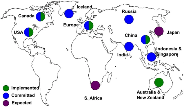
Automatic Dependent Surveillance – Broadcast (ADS-‐B) is expected to be the basis of the future surveillance system in the United States, supplemented by the current RADAR system. As shown in Figure 1, many other countries worldwide are also implementing ADS-‐ B. Purple circles indicate that a government has evaluated ADS-‐B and that a move to implement it in the future is likely. Blue circles identify governments that have made the decision to deploy ADS-‐B and have begun taking the required steps to implement ADS-‐B. Lastly, green circles identify governments that have implemented ADS-‐B on a national scale. Partial circles indicate that ADS-‐B is available in at least part of the country.
Figure 1: Worldwide Status of ADS-‐B Implementation in March 2011 (FreeFlight Systems 2009) USA Canada Iceland Russia Europe S. Africa India China Australia & New Zealand Japan Indonesia & Singapore Implemented Committed Expected
ADS-‐B is a technology where avionics onboard the aircraft broadcast messages with information relevant to Air Traffic Control (ATC) and nearby aircraft once every second. The broadcast information includes: latitude and longitude, aircraft velocity, aircraft altitude, transponder code, the aircraft’s call sign as well as other elements.
The ADS-‐B system also has data link capability where information can be linked from the ground to aircraft while in flight. Information available via data link includes weather data as well as airspace status information (NOTAMs).
The information transmitted from aircraft via ADS-‐B is first determined by, and thus
dependent on the aircraft’s onboard navigation unit (e.g. GPS or IRU). With aircraft
dependent surveillance, the aircraft and its avionics become an integral part of the surveillance infrastructure of the National Airspace System (NAS). As such, ensuring that aircraft are equipped with the required avionics is crucial.
Some of the ADS-‐B applications require more than one aircraft to transmit ADS-‐B messages. Thus, benefit from ADS-‐B to a given user is co-‐dependent on the level of equipage of other aircraft. As a result, a threshold level of system wide aircraft equipage is required to justify changes in aircraft operation and ATC procedures. Ensuring equipage across all stakeholders to reach this threshold level is thus paramount to the delivery of benefit from ADS-‐B (Marais and Weigel 2007) One way to stimulate this equipage is to provide benefits that result from use of the technology (“user benefit”). The more user benefit a stakeholder perceives from a given technology, the more likely that stakeholder is to equip with that technology.
Two of the major stakeholders that operate aircraft in the National Airspace System are Commercial Aviation (FAR Part 121 operators) and General Aviation (e.g. Part 91 or 135). In the United States, General Aviation (GA) makes up over 96% of all active aircraft in the National Airspace System. Figure 2 shows the Bureau of Transportation Statistics (BTS) record of all active aircraft from 1960 to 2011. In this plot, Part 135 operations are considered to be part of General Aviation.
Figure 2: Comparison of General Aviation to Air Carrier Active Fleet. General Aviation Includes Air Taxi (BTS)
Though GA aircraft vastly outnumber air carrier aircraft, yearly GA aircraft utilization is much lower, as is apparent in Figure 3. Average yearly hours flown by air carrier aircraft have been increasing over the past years to 2406 hours while General Aviation aircraft have seen a slight decrease to 114 hours. Thus, the average yearly utilization of an air carrier aircraft is 21 times higher than that of a GA aircraft.
Since many ADS-‐B user benefits are dependent on utilization, concern exists that ADS-‐B may not deliver enough user benefit to GA and thus not provide sufficient incentive for GA to equip voluntarily. Additionally, GA tends to be more cost sensitive as expenses often are paid out-‐of-‐pocket by the aircraft owner.
A schematic representation of a cost/benefit distribution for of a multi-‐stakeholder system such as ADS-‐B is shown in Figure 4 for three hypothetical stakeholders. Stakeholder 3 receives strong benefit at a low cost while stakeholder three incurs higher costs than benefits received. Stakeholder three is thus less likely to equip voluntarily with this technology than stakeholder 1.
Figure 4: Schematic Representation of Multi-‐Stakeholder Cost/Benefit Distribution (Adapted from Marais and Weigel 2007)
Recognizing the need to ensure high levels of equipage, the FAA in 2009 published a mandate requiring ADS-‐B equipage for certain airspace by 2020. With a mandate, the benefit of operating in that airspace is tied to equipping with ADS-‐B, thus creating a strong incentive. However, the Federal Aviation Administration is interested in identifying near-‐ term benefits in order to stimulate voluntary equipage ahead of the mandate as well as to reduce stakeholder opposition. As mentioned, GA presents a special case and thus requires a special focus.
To identify the near term benefits from the perspective of GA, a thorough understanding of GA and the benefits of ADS-‐B is required. To develop this understanding is the motivation for this thesis.
Significant Some/Indirect None/ Insignificant Level of Benefit/Cost b1(t) b2(t) b3(t) stk1 stk2 stk3 benefits c1(t) c2(t) c3(t) costs stk1 stk2 stk3
Chapter 2
O
VERVIEW OF
ADS-‐B
S
YSTEM
A
RCHITECTURE
The current aircraft surveillance system in the US uses ground based RADAR sensors to determine position and velocity of aircraft in the National Airspace System. However, most modern aircraft have advanced navigation systems that are often capable of determining the aircraft’s position and velocity much more accurately than RADAR. Taking advantage of that capability, ADS-‐B broadcasts the more accurate information and thus has the potential to provide higher position and velocity accuracy, direct heading information as well as geometric and barometric altitude. Also, at once per second, ADS-‐B has a higher update rate than RADAR which updates once every 4.8 seconds in the Terminal Area and once every 12 seconds in en-‐route airspace. Additionally, since ADS-‐B only uses relatively simple and low maintenance antennas as ground infrastructure (refer Figure 8), ground station can be placed in more strategic locations, potentially increasing total surveillance coverage area. Figure 5 is a schematic representation of the overall ADS-‐B system. Aircraft equipped with ADS-‐B avionics broadcast their position, altitude, direction and magnitude of ground speed, and other information pertinent to pilots and air traffic controllers at least once per second. This broadcast is defined as “ADS-‐B Out” and is depicted by the blue arrows in Figure 5. Ground stations receiving these ADS-‐B messages forward them via a private network to the responsible FAA facilities for display on the air traffic controller’s screen. ADS-‐B Out messages can also be picked up by other aircraft in the vicinity. This capability of receiving ADS-‐B on-‐board the aircraft is defined as “ADS-‐B In” (depicted by the green arrows in Figure 5).
Figure 5: Schematic Representation of ADS-‐B
ADS-‐B In messages that originated from other aircraft can be used to display traffic in the vicinity to the pilot using a cockpit display of traffic information (CDTI, Figure 6).
Figure 6: Cockpit Display of Traffic Information (CDTI)
ADS-‐B also has a data link capability. Messages can originate from the ground stations and be used to uplink additional data directly into the cockpit. Two types of data link messages
ADS-‐B Out and In
ADS-‐B In: Information transmitted from ground (TIS-‐B, FIS-‐B, ADS-‐R) or other aircraft ADS-‐B Out: Aircraft state vector broadcast to ground or other aircraft ATC Integration Aircraft Capability/ Avionics Equipage Ground Infrastructure/ ATC Integration Operating Procedures
have been defined: Traffic Information Service – Broadcast (TIS-‐B) and Flight Information Service – Broadcast (FIS-‐B). These messages will provide traffic, weather and NAS Status information to appropriately equipped aircraft.
FIS-‐B was originally introduced to increase user benefit to GA and thus provide increased equipage incentives. However, the frequency that was originally proposed to be used for ADS-‐B (1090MHz) had insufficient bandwidth to support FIS-‐B1. As a result, the FAA
decided to implement a dual link strategy and provide ADS-‐B services on two frequencies: 1090ES ADS-‐B mostly for Air Transport and Universal Access Transceiver (UAT) ADS-‐B for General Aviation. Table 1 outlines the main differences between the two links. Note that FIS-‐B is only available on UAT:
Table 1: Differences Between 1090-‐ES and UAT ADS-‐B Link
Mode S Extended Squitter 1090ES Transceiver (UAT) Universal Access
Frequency 1090 MHz 978 MHz
Frequency shared with TCAS, Primary RADAR, TIS-‐B, ADS-‐R FIS-‐B, TIS-‐B, ADS-‐R Intended User Air Transport, High-‐End General Aviation General Aviation Technical Standard DO-‐260B, as outlined in TSO-‐166b DO-‐282B, as outlined in TSO-‐154c
The decision to implement two separate links introduces additional complexity to the ADS-‐ B system: Aircraft on one link are not able to receive ADS-‐B messages transmitted on the other frequency. To address this issue, Automatic Dependent Surveillance – Rebroadcast (ADS-‐R) was implemented. ADS-‐R is the capability of ADS-‐B ground stations to rebroadcast messages received on the UAT link to the 1090ES link and vice versa. This allows aircraft equipped with ADS-‐B In to receive ADS-‐B Out messages from aircraft on the other link with a one second delay.
Introducing UAT also has implication on an international level. The international ADS-‐B standard is the 1090ES link; any aircraft with UAT ADS-‐B avionics would have to follow
1 1090MHz is the interrogation frequency for ground based RADAR. Also, TCAS operates on
that same frequency. Concerns exist that adding ADS-‐B, TIS-‐B and FIS-‐B to 1090 would overly congest it and reduce the efficiency of TCAS and RADAR.
special procedures to leave the US since it would not comply with the international 1090ES ADS-‐B standard.
The FAA has divided ADS-‐B services into two criticality levels: “Critical” and “Essential”. ADS-‐B messages transmitted by aircraft as well as ADS-‐R messages are considered Critical because they support applications such as aircraft surveillance and separation. TIS-‐B and FIS-‐B are considered Essential since they are advisory in nature and support applications at an essential but not critical level. (Surveillance and Broadcast Services Program 2010) As indicated in Figure 5, the overall system architecture can be broken down into three major system elements: Aircraft Capability, Ground Infrastructure and Operating Procedures. Each one of these aspects will be addressed individually.
2.1 Aircraft Capability – Aircraft Avionics
The airborne capability of ADS-‐B consists of the ADS-‐B avionics on board appropriately equipped aircraft. In 2009, the FAA published the ADS-‐B mandate that dictates the required capabilities of these ADS-‐B avionics. Chapter 3 will address avionics architectures onboard aircraft in more detail – this section introduces the airborne capability and its requirements as part of the overall ADS-‐B system architecture.
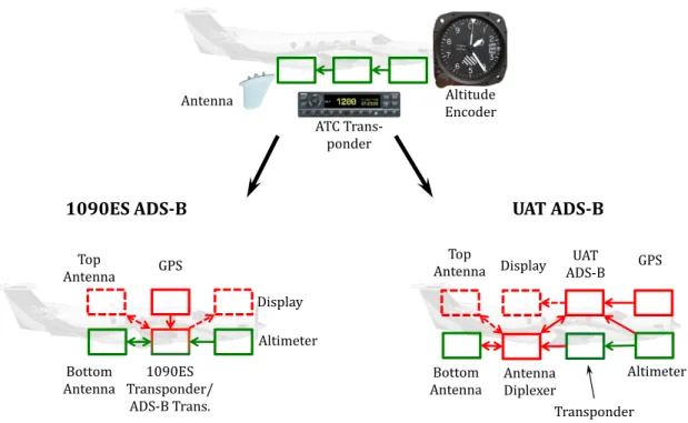
Every ADS-‐B avionics architecture compliant with the mandate has two core components: A navigation unit providing position and velocity information and an ADS-‐B transceiver that transmits that information on one of the two link frequencies. One concern among GA is that many active aircraft do not currently have certified navigation units installed. Operators would thus have to equip with a certified navigation unit in addition to an ADS-‐B transceiver. As addressed in Chapter 3, such navigation units can be expensive.
2.1.1
ADS-‐B
O
UTM
ANDATEThe ADS-‐B Out mandate outlines requirements and performance standards for ADS-‐B Out avionics. The rule states that “… [ADS-‐B Out] equipment will be required for aircraft operating in classes A, B and C airspace [and] certain class E airspace.” This Class E airspace is airspace above 10,000ft and within the Mode C veils of busy airports. Currently, the FAA is not mandating ADS-‐B In equipage (FAA 2010).
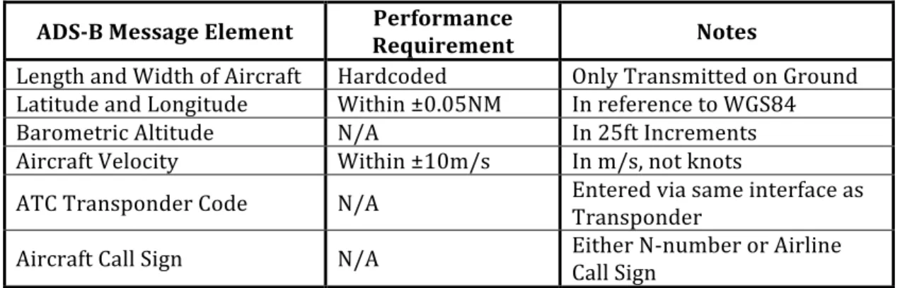
The rule also dictates the minimum contents of the ADS-‐B message and sets performance requirements for each one of those elements. These performance requirements were set to enable ATC to conduct aircraft surveillance with ADS-‐B that is at a level equivalent to the
current RADAR based system. However, certain proposed applications of ADS-‐B may require higher performance requirements than those outlined in the rule. Operators desiring to use those applications would have to equip with equipment that meets those higher requirements. Table 2 lists a subset of the required message elements – Appendix A contains a table listing all elements required by the rule and their performance requirements.
Table 2: Subset of ADS-‐B Message Elements Required by the Mandate and Their Minimum Performance Requirements
ADS-‐B Message Element Performance Requirement Notes
Length and Width of Aircraft Hardcoded Only Transmitted on Ground Latitude and Longitude Within ±0.05NM In reference to WGS84
Barometric Altitude N/A In 25ft Increments
Aircraft Velocity Within ±10m/s In m/s, not knots
ATC Transponder Code N/A Entered via same interface as Transponder Aircraft Call Sign N/A Either N-‐number or Airline Call Sign
2.2 ADS-‐B Ground Infrastructure
The physical ADS-‐B Ground Infrastructure consists of the physical ADS-‐B antennas on the ground, the network infrastructure required to transmit the received messages to the relevant ATC centers as well as the systems required to fuse the surveillance data from ADS-‐ B with surveillance data from the currently existing RADAR infrastructure.
The FAA has externally subcontracted the deployment of the nationwide ADS-‐B system. Figure 7 shows the predicted ADS-‐B coverage for the US at full implementation. Areas highlighted in blue have a predicted ADS-‐B surveillance coverage at or below 1800ft AGL. 794 ADS-‐B ground stations (depicted in Figure 8) are expected to be deployed in the US by 2013. The contract requires the ADS-‐B surveillance volume to be equivalent or bigger than the currently existing RADAR volume. However, given the number and locations of planned stations, the actual ADS-‐B coverage is expected to exceed RADAR coverage in many areas.
Figure 7: Predicted ADS-‐B Coverage at Full Implementation
Some of the stations will be collocated with existing RADAR infrastructure. Most of the ground stations, however, will be self-‐contained towers and housing with one omni-‐ directional UAT antenna and four directional 1090MHz antennas. The towers also have two dual channel communication radios and antennas and in some locations an automatic weather observation station (AWOS) station. To support operations during a loss of electrical power, each station has a diesel generator and batteries.
Figure 8: Temporary Installation of an ADS-‐B Antenna on a Terminal Area RADAR Tower in Brisbane, Australia (credit: Greg Dunstone)
ADS-‐B messages from aircraft, once received by the ground station, are routed via private networks to three control stations in Ashburn, VA, Dallas, TX and Phoenix, AZ. At those control stations, duplicates are removed (if more than one station received the message) and all messages are grouped by geographical location. “The control stations must then validate targets in one of three ways: correlation with RADAR data, reports from two 1090 radios with the aircraft in view, or pseudo-‐ranging from a single UAT radio which time tags transmissions. ADS-‐B messages are then forwarded to the FAA marked as ‘valid’, ‘invalid’ or ‘unknown’.” (Warwick 2010). This process is completed within 0.7sec from reception of the ADS-‐B message at the ground station. The three control stations also receive the RADAR data from the nationwide Host Air Traffic Management Data Distribution System (HADDS) and use it to create the TIS-‐B messages.
2.3 ADS-‐B Operating Procedures
ADS-‐B Operating Procedures will supplement the current ATC procedures and outline the interactions between the airborne and the ground-‐based elements of the ADS-‐B system. Current, RADAR based ATC procedures are outlined in FAA/DOT Order 7110.65S, “Air Traffic Control” (FAA 2008). This order is a collection of rules describing how air traffic is to be directed in the NAS by air traffic controllers. A majority of those procedures are for regulating flight in Instrument Meteorological Conditions (IMC). In addition to JO 7110.65S, Federal Aviation Regulations (FAR) Parts 91, 121 and 135 outline rules, rights and procedures of pilots and airlines. Lastly, the Aeronautical Information Manual (AIM) lists recommended procedures for flight operations for pilots.
With the introduction of ADS-‐B as an additional surveillance source, these existing procedures will need to be amended and updated to allow for operations using ADS-‐B. The expected changes to these existing procedures can be categorized into two groups: Adoption of existing RADAR procedures where ADS-‐B surveillance is equivalent to RADAR surveillance and Introduction of new ADS-‐B specific procedures.
2.3.1
A
DOPTION OFE
XISTING,
RADAR
B
ASEDP
ROCEDURESThe adoption of existing RADAR procedures outlined in 71110.65S allows for their use with ADS-‐B as well as RADAR surveillance. As such, this step grants “RADAR Equivalence” to ADS-‐B for surveillance purposes. Examples of procedures in this first category include aircraft vectoring, separation services and VFR Flight Following. In February 2010, the FAA declared “Initial Operating Capability” of ADS-‐B for surveillance purposes over the Gulf of
based surveillance will be available across all of the US. The improvement in surveillance data quality due to ADS-‐B may result in a reduction of “play” present in current operations. Also, the additional information present in ADS-‐B messages may increase overall controller situation awareness.
One promising aspect resulting from the RADAR equivalency of ADS-‐B is that it would allow for a low cost expansion of the current surveillance coverage volume to remote or mountainous regions. Although these improvements in surveillance coverage and quality offer some benefit, they alone may not warrant the introduction of ADS-‐B and do not take advantage of much of the information available in the ADS-‐B message. In order to take advantage of this information, new, ADS-‐B specific procedures will have to be introduced.
2.3.2
I
NTRODUCTION OFN
EW,
ADS-‐B
S
PECIFICP
ROCEDURESThe introduction of new ADS-‐B specific procedures enables new capabilities in the NAS. Those capabilities are expected to provide a majority of the benefit from ADS-‐B. (FAA 2010) In order to introduce new ADS-‐B procedures, a rigorous process must be followed to ensure their safety and effectiveness. Required steps include but are not limited to developing a Concept of Operations (ConOps), conducting a full safety analysis (known as Operational Hazard Analysis, or OHA), flight testing and training pilots and air traffic controllers.
The initial focus of the development of ADS-‐B has been on deploying the ground infrastructure, and as a result the development and definition of procedures has received less attention. In order to deliver benefit from ADS-‐B, operating procedures are a required. Therefore, the creation of operating procedures is of utmost importance for the delivery of user benefit that ultimately creates incentives for equipage.
2.4 ADS-‐B Applications
An “ADS-‐B Application” is a specific purpose for which ADS-‐B is used in the NAS. ADS-‐B applications can be grouped into three categories: Data Link Applications, ADS-‐B Out Applications and ADS-‐B In Applications. Based on a literature review, 32 proposed applications were identified. The reviewed Literature included: FAA technical documentation such as DO-‐260 and DO-‐282, EUROCONTROL’s Action Plan 23 (defines ADS-‐ B implementation strategies for Europe), as well the Application Integrated Working Plan (v2) (FAA 2010). Additionally, in 2009 Jenkins conducted a thorough review of proposed ADS-‐B applications (Jenkins 2009). The applications listed in her thesis were also included in this review. The applications were then categorized based on the required ADS-‐B
functionality (Out, In, Data Link) and duplicates removed. These categories are discussed int eh following sections.
2.4.1
ADS-‐B
O
UTA
PPLICATIONSADS-‐B Out applications are based solely on ADS-‐B Out transmissions from aircraft and are mostly limited to ATC surveillance applications. Nonetheless, some proposed procedures do take advantage of ADS-‐B specific information, introducing new capabilities based on ADS-‐B Out. Table 3 is a list of proposed ADS-‐B Applications.
Table 3: List of Proposed ADS-‐B Out Applications
Application Name: Concept/Description :
ATC Surveillance in Non-‐ RADAR Airspace (ADS-‐ B-‐NRA)
Provide ATC surveillance in non-‐RADAR areas such as below current RADAR coverage or offshore operations areas (e.g. Gulf of Mexico) using current RADAR Procedures. Conceivably, new procedures could be created using surveillance information provided by the ADS-‐B message. ADS-‐B Flight Following Due to the higher coverage volume and the increased surveillance quality and information available, ATC will be able to better advise pilots of
nearby traffic, minimum safe altitude warnings (MSAW), etc. Improved Search and
Rescue
Flight track data serves as an input to search and rescue operations. Having better accuracy of the last know position, a faster update rate, more specific information about the aircraft as well as a bigger coverage area, ADS-‐B will enable more efficient and more accurate responses to emergency situations.
Company/Online Flight Tracking
Current Flight Tracking is limited to areas with SSR coverage. ADS-‐B increases this coverage. Information available in the ADS-‐B message allows aircraft to be identified more readily. This would, e. g., allow operators or companies to improve their fleet scheduling.
ATC Surveillance for En-‐ Route Airspace (ADS-‐B-‐ ACC)
ATC will use ADS-‐B surveillance information in the same manner as RADAR surveillance, e.g., to assist aircraft with navigation, to separate aircraft, and to issue safety alerts and traffic advisories. The ADS-‐B surveillance information will be used to enhance the quality of existing RADAR-‐based surveillance information. Conceivably, a 3NM separation standard may be acceptable.
ATC Surveillance in Terminal Areas (ADS-‐B-‐ TMA)
Current RADAR surveillance will be enhanced in Terminal Areas. An example would be airports with single RADAR coverage. ADS-‐B information could be used to enhance current ATC procedures or ATC automation systems such as tracking or minimum safe altitude warnings (MSAW).
Airport Surface
Surveillance and Routing Service
ADS-‐B surveillance is provided to air traffic controllers to enhance situational awareness with respect to vehicles (including ground vehicles) operating on the airport surface. ADS-‐B surveillance may also be provided to ground automation and decision support system to aid in the management of traffic flow on the airport surface. This application may allow ASD-‐X like environments at non ASD-‐X airports. Conceivably, a pilot or ATC alerting function could be added to this application.
ATC Automation Integration/Automatic Flight Plan Cancellation
Using information provided by the ADS-‐B message, some ATC functions could be automated. One such application could be automatic flight plan opening or closing.
ADS-‐B Enhanced Parallel Approaches/ADS-‐B PRM
This application applies to two different environments. First, it would enhance parallel approaches at airports which use a precision runway monitoring RADAR (PRM). ADS-‐B may enhance surveillance quality. Second, ADS-‐B surveillance may allow airports without PRM to have a PRM like environment.
ADS-‐B Emergency Locator Transmitter (ELT)
The ADS-‐B message has the capability to transmit a "Downed Aircraft" message. This could double as an ELT functionality.
Enhanced Tower Situational Awareness in Reduced Visibility
Using ADS-‐B, a virtual image could be created to aid Situation Awareness for tower controllers.
ADS-‐B Enabled Portable Devices for Airport or FBO Employees
Airline Employees (e.g. ramp operators) receive ADS-‐B reports from aircraft in their fleet and use the data to optimize allocation of ground infrastructure, such as gate space and support vehicles.
Weather Reporting to Ground
If aircraft are equipped accordingly, weather specific information could be transmitted via the ADS-‐B message improving weather briefings to pilots on the ground and to enhance forecasting.
2.4.2
D
ATAL
INKA
PPLICATIONS:
FIS-‐B
ANDTIS-‐B
Data link applications take advantage of the capability of ADS-‐B to link data directly to the cockpit. Traffic Information Service – Broadcast (TIS-‐B) and Flight Information Service – Broadcast (FIS-‐B) are examples of this kind of application. These applications are called “Essential Services” for FAA and ATC purposes.
Table 4: List Data Link Applications
Application Name: Concept/Description :
TIS-‐B
Using secondary RADAR surveillance data, messages of non-‐ADS-‐B traffic are transmitted to the aircraft. TIS-‐B is not expected to be required once a threshold level of equipage is achieved.
FIS-‐B FIS-‐B messages contain weather data (such as Doppler RADAR images) as well as NAS status information (NOTAMS, TFRs, etc.) and are updated every 5 minutes.
With TIS-‐B, traffic information is linked directly to the cockpit from the ground. ITT, the main contractor installing the ground infrastructure for ADS-‐B describes TIS-‐B as follows: “The TIS-‐B service provides active ADS-‐B users with a low-‐latency stream of position reports of non-‐ADS-‐B equipped aircraft” (ITT 2010) These reports are generated using secondary RADAR data. TIS-‐B traffic information is in addition to the ADS-‐B messages received directly from other ADS-‐B aircraft via ADS-‐B In.
TIS-‐B is not continuously transmitted. For a ground station to start transmitting TIS-‐B to a given aircraft, two requirements have to be met: First, that aircraft has to be transmitting ADS-‐B Out and be capable of receiving ADS-‐B In. Second, there has to be a non-‐ADS-‐B target within the vicinity of that aircraft.
The FIS-‐B service is a broadcast of weather and NAS status information. The broadcast data is specific to the location of a given ground station. FIS-‐B is only broadcast on UAT and not on 1090ES. Unlike TIS-‐B, FIS-‐B is broadcast regardless of whether any “client” aircraft are in the service volume. FIS-‐B currently contains the following weather and NAS products: (ITT 2010) 1. AIRMET 2. SIGMET 3. Convective SIGMET 4. METAR 5. PIREP 6. TAF 7. Winds/Temperatures Aloft 8. CONUS NEXRAD 9. Regional NEXRAD 10. NOTAM 11. SUA
Similar to TIS-‐B, the information received via FIS-‐B can be displayed in the cockpit on a separate Multifunction Display (MFD, Figure 9) or possibly on a CDTI in combination with TIS-‐B.
Data Link applications are expected to provide substantial benefit to GA. GA often does have access to this kind of data while in flight. Providing free access traffic information, weather and NAS status information is expected to aid flight crews in decision making and thus reduce accidents.
Figure 9: FIS-‐B Information Displayed on MFD
2.4.3
ADS-‐B
I
NA
PPLICATIONSADS-‐B In applications are enabled by the ability of aircraft to receive ADS-‐B messages from surrounding aircraft. Applications of this kind are expected to introduce new capabilities into the NAS as well as move some of the functions ordinarily performed by ATC to the pilot. Much ADS-‐B user benefit is expected from this kind of application.
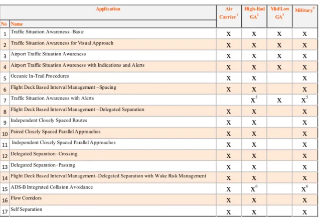
In a recent effort to get consensus on the definitions and functionalities of ADS-‐B In applications, the FAA created the ADS-‐B Integrated Working Plan (AIWP). The AIWP was written by a government/industry panel focusing on the identification and definition of ADS-‐B In applications. Table 5 lists the applications and their description as identified by the AIWP. (FAA 2010)
Table 5: List of ADS-‐B In Applications Proposed in the AIWP
Application Name: Concept/Description :
Traffic Situation Awareness–Basic
Flight crews use this application […] to supplement their visual scan. The display enables detection of traffic by the flight crew. The information provided on the display also reduces the need for repeated air traffic advisories and is expected to increase operational efficiencies. Traffic Situation
Awareness for Visual Approach
The flight crew uses the display to assist in the visual acquisition of a specific target to follow and manual selection of the traffic for coupling. The cockpit display provides ground speed or closure rate information relative to the coupled target continuously throughout the approach. Airport Traffic Situation
Awareness
The application is expected to be used by the flight crew to aid in detection of traffic related safety hazards on taxiways and runways including aircraft on final approach. This assists the flight crew with early detection of traffic conflicts and runway incursions.