HAL Id: hal-01147690
https://hal.archives-ouvertes.fr/hal-01147690
Submitted on 9 Aug 2017
HAL is a multi-disciplinary open access
archive for the deposit and dissemination of
sci-entific research documents, whether they are
pub-lished or not. The documents may come from
teaching and research institutions in France or
abroad, or from public or private research centers.
L’archive ouverte pluridisciplinaire HAL, est
destinée au dépôt et à la diffusion de documents
scientifiques de niveau recherche, publiés ou non,
émanant des établissements d’enseignement et de
recherche français ou étrangers, des laboratoires
publics ou privés.
Coastal Views: a Key Component of Riviera Coastal
Systems. A Case Study from the French Riviera
Samuel Robert
To cite this version:
Samuel Robert. Coastal Views: a Key Component of Riviera Coastal Systems. A Case Study from the
French Riviera. Littoral 2004. 7th International Symposium. Delivering Sustainable Coasts:
Connect-ing Science and Policy., EUCC; EUROCOAST, Sep 2004, Aberdeen, United KConnect-ingdom. pp.413-418.
�hal-01147690�
Coastal Views: A Key Component of Riviera Coastal Systems
A Case Study from the French Riviera
Samuel Robert
Ph.D researcher, CNRS / UMR ESPACE 6012, 98 Boulevard Herriot BP3209 06204 Nice Cedex 03 France, srobert@unice.fr
Abstract
Among famous seaside resort areas, rivieras are complex coastal systems where, more than in any other coastal region, coastal views have an economic value and can be considered as a heri-tage. Resulting from the combination of an indented coastline, an amphitheatre or balcony shaped topography and accessibility to viewpoints, coastal views are a major component of riviera systems. They are part of the riviera identity and they considerably influence territorial developments. Taking the French Riviera – part of the Côte d’Azur stretching from Nice to Menton - as a case study, we will illustrate panoramic views’ importance through road devel-opments. Viewshed analysis achieved with GIS gives indeed clear evidence of how coastal views from roads have been valorized by sightseeing. The issue of view management in coastal areas should be discussed. Natural as well as man-made heritage, coastal views are affected by land use change. Using systems analysis, we will try to identify threats and preservation strate-gies related to them.
1. COASTAL VIEWS IN THE RIVIERA COASTAL SYSTEM
As anyone can admit, beautiful panoramas are an asset for tourism, particularly where topogra-phy creates sightseeing facilities. In this respect, unlike other seaside resort areas, rivieras have very much to do with coastal views. Wide scener-ies are specific to these coastal systems : they participate in their fame, they considerably influ-ence their land-use management and they are part of the heritage. Nevertheless, something must be said about these complex coastal regions, as many coasts known as “rivieras” do not comply with the riviera coastal system.
1.1 What is a Riviera?
“Riviera” is a rather confusing name. Bor-rowed from Italian, it has been adopted in English to refer to the Mediterranean areas where the very first seaside resorts of modern tourism appeared: the South Eastern coast of France and the North Western coast of Italy. Later on, it has been gen-eralized to describe various coastal areas popular with tourists in the world (the Mexican riviera of Cancun, the Cornish Riviera in England, ...), in-cluding in Italy (Riviera di Rimini). To some ex-tent, it is also related to urbanised coastal regions where tourism is key. But, a tourism-oriented economy is not a clear indicator of what a riviera is, as many seaside resort areas in the world are not named like this.
In Liguria, where the term “riviera” originally comes from, riviera refers to a specific coastal system based on a mountain / sea interface, more than a tourism-oriented coastal area. This is the base of our riviera coastal system definition. Therefore, Rimini on the Adriatic coast of Italy is not a “riviera” as in the Ligurian sense and neither
is the coast of Brighton in South England. But the Amalfitan coast (South East of Naples) as well as the Costa Brava (North East of Spain) might be named rivieras as they do resemble the riviera coastal system.
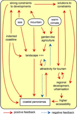
Figure 1: Basic Riviera Coastal System.
1.2 The Riviera Coastal System
Being a mountain / sea interface, the riviera coastal system is very much concerned with to-pographic issues (Figure 1). The physical envi-ronment (topography, climate, sea characterictics) can be considered as key :
- no plane areas but steep slopes, space scarcity, natural hazards and risks, low accessi-bility,
- warm climate, climatic shelter provided by mountains, slopes well exposed to sunlight.
This shelter has been developped by agricul-ture (flowers, citrus fruits, etc.), rarely by industry (Genova and Savona, two industrial harbours in Liguria, are exceptions) and of course by tourism (Vallega, 1991). Nevertheless, until quite recently (19th century), most of these coasts remained poor regions because they were hard to develop and isolated (due to a bad transportation network).
From the end of the 18th century onward, with the beginning of the “winter season”, nice climate, beautiful landscapes and sceneries have made many of these primarily repellent coasts very at-tractive to tourists. Some rivieras became very popular and started to change. Strong territorial transformations occurred, mainly produced by tourism. Nowadays, for many rivieras, this suc-cess also means urbanisation, traffic congestion, agriculture’s decline, landuse competition, the rise of real estate prices, and landscape degradation.
In terms of coastal area management, consid-ering rivieras as specific coastal zones is a prereq-uisite as they are very different from other seaside resort areas. Land planning, landscape manage-ment and conservation can’t be conducted like in any other tourism-oriented coastal region. This is essentially due to the specific environmental con-ditions.
1.3 Riviera and Coastal Views
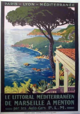
Where tourism has emerged and later on pros-pered, landscapes and panoramas are a key issue. Along with the climate, early settlers and tourists looked for exotic and beautiful sceneries. They enjoyed evergreen and colourful vegetation, blue skies and coastal views. Many of the first “villas” and “Grand Hotels” were installed far from the sea but had privileged panoramas onto the coast, as one can still see today from the Chateau de
l’Anglais in Nice, the Villa Maria Serena in
Men-ton, Hanbury Villa and Gardens in Ventimiglia or the “Swallow’s Nest” near Yalta in Crimea, Ukraine (Figure 2).
Figure 2: A 1925 Poster of the of the South Eastern Coast of France by PLM (Paris Lyon Méditerranée Railways).
Figure 3: A 1935 Poster of Roquebrune Cap Martin by PLM.
During the 20th century, with the rise of the automobile, road developments have been made in order to make sightseeing easier on the coast. In South Eastern France, the three “corniches” link-ing Nice with the Italian border via Monaco are the best example (Figure 3). They have “opened” the scenery to everybody and have confirmed coastal views as one of the symbols of the riviera, a key element of this coastal system. Other roads of this kind can be found around Yalta in Crimea or Amalfi in Italy. Nowadays, panoramas have gained an economic value which is still an asset for these coastal areas but also a threat. Real estate prices have reached incredible levels, depriving local people of buying property. New building programs, using more innovative techniques, tend to spread urbanisation on slopes and along roads, modifying land use and landscapes and making travellers deprived of coastal views, originally available from these roads.
Though some specific policies have been de-fined to protect some of these coasts from urbani-sation and speculation (land acquisitions by the
Conservatoire du Littoral in France, convention
for the protection of the Costiera amalfitana as a World Heritage by UNESCO, etc.), most of the rivieras are endangered. In spite of the increased awareness of this environmental issue, there is a real need to consider coastal views as a major concern in the realm of coastal area management. 2. VIEWSHED ANALYSIS ON THE FRENCH
RIVIERA
In order to highlight the importance of pano-ramic views in riviera coastal regions, an analysis has been conducted to assess viewsheds available from roads on the French Riviera. Based on Geo-graphical Information Systems (GIS) capabilities and a multi-temporal geographical database, cov-ering the coast from Nice to the Italian border, the analysis aims to show how panoramic views can be used into an appropriate integrated coastal area management.
2.1 Area of Study
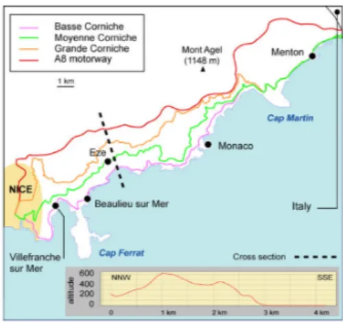
As many studies from historians have shown, Nice remained very poorly connected to other provinces of France and Italy until the 19th cen-tury. The development of the “winter season” urged the connection of the region to surrounding provinces by road as well as by rail (trains first reached Nice in 1864). In the second half of the century, various roads were constructed to im-prove the accessibility to new resorts (Beaulieu, Monte-Carlo, etc.) but also to offer new ways to discover the coast (Boyer, 2002). Built on steep slopes, with tunnels and viaducts, made of rare straight sections but many curves, these roads brought the panoramic dimension of the French Riviera to visitors. They were indeed designed to offer the best views on the coast, rather than to shorten the journey from Nice to the border (Figure 4).
To a large extent, these roads have contributed to the French Riviera identity. They offer delight-ful views on the slopes dominating the coast and the sea. This should be considered in integrated coastal zone management policies. Viewshed analysis can help on this matter.
Figure 4: Area of Study.
2.2 Methodology
The principles are quite simple. Using GIS capabilities and appropriate data files, we can calculate areas which are seen from our roads of interest. In a unique geodectic system, it is re-quired to get three elements: 1) a digital elevation model (DEM) to represent topography, 2) a road network file to represent the selected roads and 3) a landuse file to get the information on the landuse of the area viewed. Our GIS relies on the MapInfo ® and Vertical Mapper ® softwares. For each road, the analysis is made as follows (Figure 5) : - the road (polyline) is converted into a series
of n viewpoints (dots), separated by less than 250 m
- for each dot i, we know the geographical location and the altitude from the DEM - a viewshed analysis is calculated dot by dot
with selected parameters : viewshed radius= 5 km, i height = 1 m
- the output is a raster file where, according to their altitude, pixels are declared : “out of reach” (value = null), “viewed” (value = 1) or “hidden” (value = 0) from I
- to get the viewshed of the road, the n viewsheds are merged. The output is a raster file where the higher the pixel value, the more often it is viewed from the road. The data used in this work comes from a data-set described in a previous paper (Robert, 2003) and called “GIS French Riviera”. This is a multi-temporal database designed to analyse territorial and coastal changes in this famous region, where tourism is a powerful vector of change and topog-raphy an asset as well as a constraint. Here, the database has been used to perform viewshed analysis from the three roads connecting Nice to the Italian border and from the motorway.
Figure 5: Viewshed Calculation Process.
Once viewshed files are obtained, they can be compared to each other to answer the following questions : What is the road providing the widest view over the sea ? What are the places seen most often ? What is the landcover in the viewshed area?
2.3 Data Accuracy and Sources
Such an analysis depends a lot on the data used to run calculations. Here, DEM resolution and road file accuracy are critical.
Regarding the DEM, it has been made from the French Institut Géographique National Bd-Alti ® database (planimetric accuracy : 50 m, altimetric accuracy : 20 m). Its resolution is 20 m. It is suitable for middle scale analysis, that is around 1 : 50 000. The road network file comes from the Bd-Carto ®, produced by the same insti-tute. It complies with analyses ranging from scale 1 : 50 000 to scale 1 : 250 000. Since terrain data is supposed to be more accurate, the road features
file has been checked using a 50 cm orthoimage from IGN Bd-Ortho ®.
Concerning the landuse data, it partly comes from the Corine Landcover database and from our own digitization based on orthoimages. Whatever the file, scale compliance is satisfied.
3. RESULTS AND DISCUSSION
The results are maps of the areas viewed from the roads. They can be converted into statistics for quantification and comparisons. Some of these maps are quite interesting for they give clear fig-ures. Nevertheless, data quality is to be discussed. 3.1 Uneven Coastal Views
The very first interesting results are viewshed areas. Given the selected parameters (5 km radius, viewpoint height : 1 m, road considered as a series of viewpoints every 250 m), the three corniches and the motorway do not offer the same area to look at. Because of topography and road location, looking far away is sometimes possible and some-times it is not.
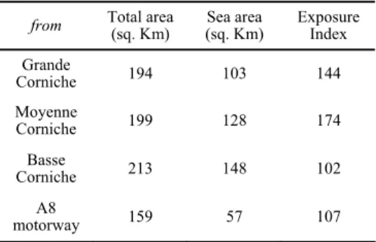
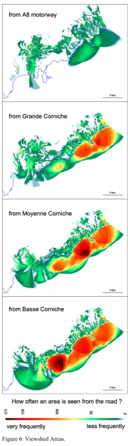
Table 1: Viewshed Characteristics.
from Total area (sq. Km) (sq. Km) Sea area Exposure Index Grande Corniche 194 103 144 Moyenne Corniche 199 128 174 Basse Corniche 213 148 102 A8 motorway 159 57 107
As shown in Table 1, the widest view is given by the Basse Corniche, the one which is at the lowest altitude. From Nice to the Italian border, the area which can be seen within a 5 km radius is 213 sq km. The two other panoramic roads offer a little less to look at, but much more than the mo-torway.
Considering the marine area which is seen from these roads, differences are higher. Statistics indicate that the Basse Corniche is the best road to observe the sea, as the water surface accounts for almost 70 % of the total viewshed. From the Grande Corniche (53 %) and A8 (36 %), the sea remains less visible. Using maps, we can observe another difference: viewsheds are not composed with the same coastal areas (Figure 6).
Maps from Figure 6 give two levels of infor-mation : 1) the geographical location of the areas contributing the most to panoramas from the roads and 2) how often a place is seen from the roads, i.e. the exposure index. It appears clearly that
unlike the three corniches, the motorway is not an appropriate route to observe the coast, except for its Eastern part. As for the corniches, they all have their geographical particularity. The area most viewed from the Grande Corniche is the Eastern part of the coastal zone, particularly the sea facing Cap Martin and Menton. Regarding the Moyenne Corniche, the area most seen is the coastal zone of Monaco. Finally, from the Basse Corniche, the best viewed area is the sea facing Beaulieu sur Mer and Eze, in the Western part of the area of study.
These results can be helpful to identify sensi-tive areas. They show the sites and places that contribute to the sceneries appreciated by visitors. As a matter of fact, they should be integrated in land planning policies since they locate terrains and landscape having a true cultural and economic value.
3.2 Data Acuracy and Viewshed Relevance As suggested earlier, results rely on data qual-ity, particularly on DEM data. As for panoramas, visual obstacles can be diverse and of various sizes. Mountains, but also trees, buildings or houses can prevent travellers from having a nice view to look at, even from the famous corniches. This obviously means that our results cannot be used at every scale.
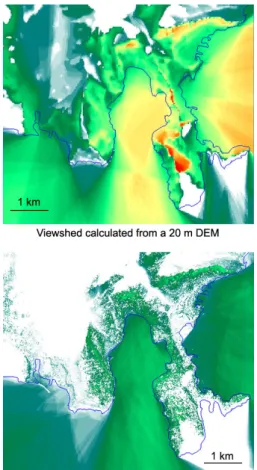
In order to further explore viewshed useful-ness, a trial has been made with a more detailed and accurate elevation data file. Because of a very long calculation time, the original dataset (1 m resolution, 1 m XY accuracy, 1 m Z accuracy, provided by Istar ®) has been downsampled at 5 m resolution and the test has been conducted on a smaller area. The Western part of our area of study (from Nice to Beaulieu sur Mer) has been selected and viewsheds have been calculated from the Basse Corniche only. The comparison between the 5 m DEM based viewhed and the 20 m DEM based viewshed is spectacular (Figure 7). The area that can be looked at is much smaller. Buildings and vegetation are true obstacles, particularly in the western part of the image where the road en-ters the city of Nice. Surrounded by multistorey buildings, the Basse Corniche can’t offer more than glances on the sea. This output reveals how far buildings which align the road can affect coastal views. In terms of urban planning, viewshed analysis can therefore be of great help, particularly on the French Riviera where a site beauty has an economic value. It can be used by local authorities - stressed by real estate compa-nies, in search for terrains - to find ways to both preserve sites and satisfy the demand for new constructions.
Figure 6: Viewshed Areas.
Figure 7: Area Seen from the Basse Corniche, (color scale same as in Figure 6).
Managing urban and regional development along with coastal views conservation is hard to set up. But this is a true challenge for rivieras. Popular with tourists, especially with high class tourists, these coastal areas rely a lot on their beautiful landscape. But as Figure 1 shows, too much urbanisation can affect coastal panoramas by land-use change and finally threaten global development. This is particularly true in the Medi-terranean zone where coastal areas still remain attractive and tend to propel their dynamism into their hinterland (Voiron-Canicio, 1999). As for rivieras, this is not without causing serious dam-ages to landscape quality along with an increase in natural hazards.
4. CONCLUSIONS
Rivieras are fragile coastal zones. Though the name is quite confusing, this paper intends to say
more about these coastal systems based on a mountain / sea interface.
Very famous throughout the world, riviera coastal systems are endangered because of too much success with tourism, in particular through the strong residential economy. Coastal views, which are a key component of these coasts, should be studied and protected. Using viewshed analy-sis, we show how urban and regional planning could integrate this heritage into a true integrated coastal zone management policy. Conservation does not mean necessarily building prohibition. Various recent projects concerning coastal plan-ning try to take this into consideration (Gaggero; Ghersi, 2002) ; that may be a good sign for rivi-eras.
ACKNOWLEDGEMENTS
The author would like to thank the Istar com-pany (www.istar.com) for his granting access to high resolution databases covering Nice.
REFERENCES
Boyer, M. 2002 L’invention de la Côte d’Azur.
L’hiver dans le Midi. Editions de l’Aube, Paris,
379 p. ISBN 2-87678-643-5
Gaggero, G. ; Ghersi, A. (eds.) 2002 Il paesaggio
di Ventimiglia e Bordighera. Percezione, identi-tà, progetto. L’esperienza della Regione Liguria nel PROGRAMMA OPERATIVO INTERREG II C PROGETTO : “Paesaggi Mediterranei ed Alpini”. Alinea Editrice, Firenze, 95 p. ISBN
88-8125-524-3
Miossec, A. 1998 Les littoraux, entre nature et
aménagement. SEDES, Paris, 192 p. ISBN
2-7181-9519-2
Robert, S. 2003 GIS and Coastal Change on the French Riviera. 50 Years of Coastal Manage-ment from Nice to Menton. CoastGIS’03, Fifth
International Symposium on GIS and Computer Cartography for Coastal Zone Management,
Genova, 16th-18th october 2003, http://www.gisig.it/coastgis/papers/robert.htm World Heritage Committee. 1998 Convention
concerning the Protection of the World cultural and Natural Heritage, 21st session, Naples, 1-6 december 1997, UNESCO
Vallega, A. (ed.). 1991 La liguria e il mare. Pu-blicazioni dell'Istituto di Scienze Geografiche, Università di Genova, Facoltà di Magistero, XLV, 246 p.
Voiron-Canicio, C. 1999 Urbanisation et littorali-sation sur les rives de la Méditerranée. Cahiers
Scientifiques de l’Artois 12, 103-112. ISBN
2-910663-37