HAL Id: hal-02335990
https://hal.univ-lorraine.fr/hal-02335990
Submitted on 28 Oct 2019HAL is a multi-disciplinary open access archive for the deposit and dissemination of sci-entific research documents, whether they are pub-lished or not. The documents may come from teaching and research institutions in France or abroad, or from public or private research centers.
L’archive ouverte pluridisciplinaire HAL, est destinée au dépôt et à la diffusion de documents scientifiques de niveau recherche, publiés ou non, émanant des établissements d’enseignement et de recherche français ou étrangers, des laboratoires publics ou privés.
Active Dewatering Of Limestone Quarry And Drinking
Water Production - Feasibility Assessment Using A
Groundwater Model
Alan Cotton, Philippe Orban, Samuel Wildemeersch, Pauline Collon, Vincent
Hallet, Serge Brouyère
To cite this version:
Alan Cotton, Philippe Orban, Samuel Wildemeersch, Pauline Collon, Vincent Hallet, et al.. Active Dewatering Of Limestone Quarry And Drinking Water Production - Feasibility Assessment Using A Groundwater Model. IMWA 2019, Jul 2019, Perm, Russia. �hal-02335990�
1
Active Dewatering Of Limestone Quarry And Drinking Water Production –
Feasibility Assessment Using A Groundwater Model
Alan Cotton1, Philippe Orban2, Samuel Wildemeersch3, Pauline Collon4, Vincent Hallet1, Serge
Brouye re2
1Department of Geology, Institute of Life-Earth-Environment (ILEE), University of Namur, Rue de Bruxelles
61, B-5000 Namur, Belgium, [email protected]
2Group of Hydrogeology and Environmental Geology, ArGEnCo, Urban and Environmental Engineering,
University of Liège, Building B52/3, B-4000 Liège, Belgium
3SPAQuE S.A., Boulevard d’Avroy 38/1, B-4000 Liège, Belgium
4Laboratoire GeoRessources, ENSG, University of Lorraine, BAT G, Vandoeuvre-Lès-Nancy Cedex, France
Abstract
Lhoist Industries Ltd. plan to deepen the Boverie Quarry (Rochefort, Belgium), in which two Frasnian limestone reefs are exploited. If this project is allowed, the dewatering will dry up the Tridaine gallery that provides drinking water for the city and Saint-Remy’s Abbey of Rochefort. Therefore, the project of deepening has to conciliate both quarry dewatering and drinking water production. The solution found by the quarry owner is to achieve the dewatering using three wells, for technical safety or water quality reasons, located in the periphery of the quarry and to distribute the pumped water to both the city and abbey. Hydrogeological characterization and a model using the SUFT3D research code tend to show that quarry dewatering and drinking water production could be achieved during and after the quarry operation, even by using a single well.
Keywords: Belgium, Quarry dewatering, Peripheral well, Drinking water supply, Groundwater modeling
Introduction
In Belgium, as in many other states having a small surface and a high population density, mineral industry and drinking water production are closely tied together. Indeed, as lateral expansion of quarries is therefore extremely limited, most of them have to be deepened. In such a case, the bottom of the extraction pit could reach the water table and a dewatering system has to be established to continue the extraction operations. Most often, quarries dewatering is carried out by means of a sump, which is by far the least expensive solution. Like any other kind of dewatering systems, sumps affect the regional hydrogeology and, occasionally, the productivity of nearby groundwater catchments by, for example, drying up the wells or increasing the pumping costs (Younger et al. 2002). In order to mitigate the impacts of quarry dewatering on groundwater catchments, mine water could be used for drinking water production. However, water that is also collected in the sumps could not be of sufficient quality to be used as drinking water without a heavy and very expensive treatment. In those cases, a viable option to reconcile both dewatering and drinking water supply is by means of drilling one or more peripheral wells.
Lhoist Industries Ltd. have chosen this alternative with regard to their project of deepening the Boverie limestone quarry in Rochefort (Belgium). At the site, the mining company operates two Devonian limestone reefs for high-grade lime production. Actually, groundwater contained in these formations is drained by the Tridaine gallery, an old artificial drainage gallery, which will dry up if the deepening project comes true. This drainage gallery provides drinking water for the majority of the 12,500 inhabitants of the city of Rochefort as well as for Saint-Remy’s Abbey of Rochefort, for beer brewing.
Even if the quarry owner has already decided to drill three wells, a groundwater flow model has been developed to assess the feasibility of (1) dewatering the quarry with a single well located in its periphery and (2) providing enough water to fulfil the water demand of both the city and abbey.
2
Context and Project Description
The Boverie Quarry is located in the southern part of Belgium, in the Famenne-Ardenne UNESCO Global Geopark. The quarry lies on a topographic ridge called “Calestienne”, which marks the limit between the Fagne-Famenne depression to the north and the Ardenne plateau to the south (fig. 1).
Figure 1 Location of the Boverie Quarry (star) within the “Calestienne” (after Poulain 2017)
The “Calestienne” is made of Givetian and Frasnian limestone and shale formations. Concerning the Frasnian stage (fig. 2), in which the quarry is located, the sedimentary sequence begins with the shale of the Nismes Formation. It continues with the limestone reef of the Arche Member, which changes laterally into the shaly Ermitage Member. The Arche Member is topped by the clayey limestone of the Bieumont Member, which precedes the second limestone reef of the Lion Member. The upper part of this limestone reef is crossed longitudinally by a major fault zone (fig. 2). The Frasnian sedimentary sequence ends with the shale of the Boussu Member, which overlaps the Lion Member. The Boverie Quarry is located in the Arche and Lion Members (fig. 2). Strike and dip are homogeneous with values of N35°E and 45 °NW, respectively.
The Arche and Lion Members are hydraulically connected together in the quarry zone and represent a single aquifer formation. It contains the water table drained by the Tridaine gallery. Due to their lithologies, the surrounding geological formations are relatively impervious and tend to isolate the aquifer. Consequently, the aquifer may be compared to “a big bathtub” with limited inflow from the surrounding geological formations. The main inputs are the recharge (410 mm/year on average) and the infiltration of the Entre-Deux-Falleux (E2F) stream in the Lion Member to the northeast (fig. 2), and the output being the Tridaine gallery (765,000 m3/year on
average). As highlighted by several pumping tests, the major fault zone in the upper part of the Lion Member induces a higher hydraulic conductivity of the aquifer in this area. Despite this fault zone, no other preferential flow paths, such as karstic phenomena, have been encountered following geophysical investigations or during the quarry operation.
Currently, the bottom of the extraction pit is limited to the altitude of 220 m.a.s.l., nine meters above the elevation of the Tridaine gallery. This drain has a catchment capacity of 50 m3/h, from
which 10 m3/h are permanently attributed to the abbey for beer brewing while the other 40 m3/h
are used by the city of Rochefort for public drinking water supply. During high water periods, the gallery discharge can increase up to 300 m3/h and the excess water overflows in surface water.
However, during low water periods, the drain discharge can decrease to 10 m3/h, jeopardizing
the water supply of the city, which needs to buy water from the regional water company, which in turn is not always able to provide the required volumes. The project of Lhoist Industries Ltd. consists in the deepening of the Boverie Quarry to the altitude of 160 m.a.s.l., drying up the
3
Tridaine gallery as a consequence. To ensure the continuous supply of drinking water, the quarry owner proposed to achieve the dewatering using three peripheral wells. In this way, the water loss during high water periods can be decreased and, last but not least, the city of Rochefort will not suffer of water scarcity during low water periods. The main pumping well (Lion-1) has been drilled in the high hydraulic conductivity zone located in the upper part of the Lion Member, 100 meters northwest from the nearest mining face (fig. 2). The borehole is 156 meters deep (bottom at the altitude of 91 m.a.s.l.), 440 mm wide and equipped with 305 mm wide stainless steel screened tubing. As expected, fractures have been intersected during the drilling operations as well as important water inflows, showing the potential high productivity of the well. It will be used as a single pumping well in the model. In the event of technical failure or water quality issue of this well, two backup wells were drilled around the quarry pit (fig.2).
Figure 2 Frasnian geological map with the location of the Boverie Quarry, Tridaine gallery (triangle), Lion-1
pumping well (diamond), backup wells (stars) and piezometers (circles) (DEM Hillshade from SPW) Groundwater modeling: Conceptual model and calibration
A groundwater flow model has been developed with the SUFT3D (Saturated and Unsaturated Flow and Transport in 3D) research code, which has already demonstrated its effectiveness in a number of previous studies (e.g. Brouye re et al. 2009; Orban et al. 2010). This code uses the finite elements method to solve flow problems in variably saturated conditions. The greatest strength of the code is its ability to subdivide the model into sub-domains to perform different water budgets in the model. Those sub-domains communicate with each other by means of internal boundary conditions to simulate groundwater flow between the different sub-domains.
The model extends over the Arche and Lion Members as well as the part of the Bieumont Member located in the extraction area. A finite element mesh of 27,000 prismatic elements (mean side length of 20 m) and 19,500 nodes, vertically divided in five layers, characterizes the model. The top of the mesh coincides with the topographic surface retrieved from a digital elevation model and the bottom has been arbitrarily set to the altitude of 50 m.a.s.l. in order to represent the future deepening of the quarry (pit bottom at 160 m.a.s.l.) as well as the whole height of the pumping well. The dip of the geological layers is also taken into account.
The conditions prescribed at the boundary of the model domain are Fourier external boundary conditions with the exception of the contact between Nismes Formation and Arche Member, which is a no-flow Neumann external boundary condition. The choice of Fourier boundary conditions has been made to represent the probable groundwater lateral inflows that may enter the model as a consequence of the decrease of the piezometric head during the quarry dewatering. A Fourier external boundary condition has also been prescribed for the Tridaine gallery.
4
In order to estimate the water budget for the Arche and Lion Members separately and to assess the quantity of groundwater flowing from the Arche Member to the Lion Member, four sub-domains have been introduced. One subdomain corresponds to each limestone reef, one to the more permeable zone of the Ermitage and Bieumont Members in the middle of the extraction pit and one to the rest of these two members. Groundwater exchanges between the different sub-domains are described by Fourier internal boundary conditions.
As explained previously, the only solicitations of the model are the recharge and the infiltration of the E2F stream. The recharge is represented by a Neumann external boundary condition prescribed on the top face of each element composing the top layer of the model domain. The recharge calculation takes into account the lack of soil and vegetation in the mined area. The infiltration of the E2F stream in the Lion Member is also represented by a Neumann external boundary condition, prescribed on the top face of each element crossed by the stream. As the downstream part of the E2F stream drains the groundwater table during high water periods, a Fourier external boundary condition has been prescribed in this zone. This boundary condition is deactivated during low water periods to avoid water inflow.
The model has been divided in ten zones to describe the spatial heterogeneity. Within each of these zones, hydrogeological parameters such as hydraulic conductivity and effective porosity are constant. Three zones correspond to the Arche Member, three more to the Bieumont Member, one to the Lion Member and the last three zones are located along the fault, in the upper part of the Lion Member.
Model calibration has been performed over a whole year (May 2010 to May 2011) based on observed data collected in five piezometers spread out in the Arche and Lion Members (fig. 2), and with the discharge of the Tridaine gallery. The simulation has been run in transient conditions, with a time step of one day and weekly solicitations. The choice of such a short time step has been made to reproduce the fast response of the aquifer to the recharge, as good as possible. The calibration has been done by trial and error approach, by changing the hydrogeological parameters of the different zones as well as the exchange coefficients of both internal and external boundary conditions.
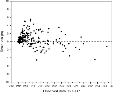
The analysis of residuals (fig. 3) shows that the model is well calibrated but tends to overestimate the piezometric head when it is low. This trend may be explained by the better calibration during high water periods, which has been done voluntarily to improve the model accuracy during high recharge events. In this way, the dewatering discharge could be ascertained precisely to avoid flooding of the extraction pit.
5
Groundwater modeling: Dewatering simulation
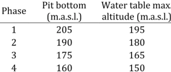
According to the blueprint of Lhoist Industries Ltd., the deepening of the Boverie Quarry would take place in four phases (tab. 1), each one corresponding to the creation and operation of a new extraction level. During each of these four phases, the bottom of the extraction pit will be lowered by 15 meters. In order to mitigate any potential groundwater contamination and to avoid any risk of flooding, the water table must be kept always at least ten meters below the bottom of the extraction pit. Giving the project specifications, the dewatering of each level should be achieved in one year and the water table should stabilize during the whole levels operation, i.e. 6.5 years.
Table 1 Operation schedule of the Boverie Quarry deepening
Phase Pit bottom (m.a.s.l.) Water table max. altitude (m.a.s.l.)
1 205 195
2 190 180
3 175 165
4 160 150
Dewatering simulation has been performed in transient conditions for a period of 30 years, with a monthly time step and monthly solicitations. The mean monthly recharge applied to the model has been calculated from the data collected between 2008 and 2017. The same recharge is applied to the model every year until the end of the simulation. Due to a lack of data, the infiltration of the E2F stream is the same one as for the model calibration. As for the recharge, the same solicitation is also applied every year. To represent the drying up of the Tridaine gallery and to avoid water inflow in the model, the corresponding Fourier boundary condition has been deactivated at the beginning of the simulation. As the downstream part of the E2F stream will not drain the groundwater table anymore during the quarry dewatering, the corresponding Fourier boundary condition has been deactivated for the whole simulation.
Modeling results (fig. 4) show that floor dewatering is achieved in one year with a constant pumping rate of 132 m3/h, except for phase 1 where the pumping rate is 145 m3/h. This higher
value required for the first floor dewatering might be explained by the higher drawdown (23 m) needed for the operation of this level, compared to the drawdown of phases 2 to 4 (15 m) (fig. 4a). On the other hand, the pumping well discharge required for the water table stabilization is constant from phase to phase, with a value of 113 m3/h (fig. 4b). The stability of the pumping rate
required during levels operation indicates that groundwater lateral inflows coming from the surrounding geological formations should be limited.
In the light of these results, the use of one single peripheral well should be enough to lower the groundwater table everywhere under the Boverie Quarry pit (fig. 4a). It is quite clear that the possibility to achieve the dewatering in such conditions mainly relies on the high hydraulic conductivity of the aquifer formation as well as on the limited lateral inflows from the surrounding geological formations. The model shows that the dewatering of the Boverie Quarry could be achieved while ensuring the drinking water supply of 50 m3/h required for the city and
Saint-Remy’s Abbey of Rochefort. Finally, a dynamic management of the well pumping rate could be done according to the hydrogeological conditions: when the local water supply rate and minimum piezometric level are respected, the well discharge could be adjusted to minimize groundwater wastage to surface water, avoiding over pumping of the aquifer.
6
Figure 4 (A) Dewatering simulation results for pumping well Lion-1 and piezometers located in the quarry;
(B) pumping well Lion-1 discharge during the different operation phases (X axis of both graphs are purely indicative)
Conclusions
The model developed with the SUFT3D research code seems to prove that the deepening project of the Boverie Quarry using one single peripheral well is feasible, owing to the high hydraulic conductivity of the aquifer as well as to the limited lateral inflows. The model has been calibrated, especially for high water periods. It shows that the discharge of the pumping well should be sufficient to guarantee the drinking water supply of both the city and abbey. However, Lhoist Industries Ltd. have already drilled two more wells, for security or water quality reasons. The modeling results still require to be validated by a long-term pumping test.
Acknowledgements
The authors would like to thank Lhoist Industries Ltd. for letting them access freely the Boverie Quarry and for sharing all the hydrogeological data they have gathered over time. The authors also thank the reviewers and Walter Verhaert who helped to improve the quality of this manuscript. Last but not least, they thank Isabelle Bonniver (UNamur) for the comprehensive hydrogeological synthesis of the site and Gae tan Rochez (UNamur) for his unconditional help during the plentiful fieldworks.
References
Brouyère S, Orban P, Wildemeersch S, et al (2009) The hybrid finite element mixing cell method: A new flexible method for modelling mine ground water problems. Mine Water Environ 28:102–114 . doi: 10.1007/s10230-009-0069-5
Orban P, Brouyère S, Batlle-Aguilar J, et al (2010) Regional transport modelling for nitrate trend assessment and forecasting in a chalk aquifer. J Contam Hydrol 118:79–93 . doi: 10.1016/j.jconhyd.2010.08.008 Poulain A (2017) Flow and transport characterization in vadose and phreatic zones of karst aquifers:
Experimental approaches in the Givetian limestones of South Belgium. PhD thesis, University of Namur, 226 pp
Younger PL, Banwart SA, Hedin RS (2002) Mine Water: Hydrology, Pollution, Remediation. Springer Science + Business Media, Dordrecht, 442 pp