.ft.
SLU
DOCTORAL THE SIS
No.
2008=78FACULTY OF FOREST SCIENCES
Land
Use Dynamics, Tree Diversity and Local
Perception of Dry Forest Decline in
Southern Burkina Faso, West Africa
Land Use Dynamics, Tree
Diversity and Local
Perception of Dry Forest
Decline in Southern Burkina
Faso, West Africa
Souleymane PARÉ
Faculty of Forest SciencesDepartment of Forest Genetics and Plant Physiology Umeå
Doctoral Thesis
Swedish University of
Agricultural
Sciences
Acta Universitatis Agriculturae Sueciae
2008:78ISSN 1652-6880
ISBN 978-91-861-9511-3 © 2008 Souleymane Paré, Umeå Tryck: Arkitektkopia AB, Umeå 2008
Cover: Forests (left), Shifting cultivation (center), illegal grazing in the Sissili protected forest (right).
Land Use Dynamics, Tree Diversity and Local Perception of Dry Forest Decline in Southern Burkina Faso, West Africa
Abstract
Conversion of tropical forests into cropland and pasture has risen incessantly during the last few decades. With the aim of providing evidence for informed-decision on sustainable forest management, this thesis examined the dynamics of land use change in Sissili province, southern Burkina Faso, whether tree diversity and natural regeneration are favored in protected forests under varying human population pressures and local perception of forest decline. Spatial analysis revealed a rapid land use change both at local and regional scales over the past 16 years, characterized by a high conversion rate of forest to agricultural land, driven by rural immigration, changes in farming systems and fuelwood extraction. The protected forest harbored relatively less species (45) than the unprotected forests (58). Irrespective of the forest conservation status, stem density and basal area were higher in a site with higher human population density than otherwise. Shannon’s measure of evenness and Fisher’s diversity index were significantly high in the less populated site and unprotected forests, respectively. Seedling density did not vary significantly between protected and unprotected forests and sites with varying human pressures, and the majority of the species was characterized by very low seedling density, with a clumped population distribution. A survey on uses of forests and perception on their decline revealed 82 plant species that are being used for various purposes (food, medicine, energy, animal feed and construction), suggesting the key role the forest resources play in poverty reduction and sustaining seasonal shocks (like food scarcity or income generation). The thesis draws the following major conclusions: 1) the size of cropland increases at the expense of declining forest cover both at local and regional levels; 2) the designation of protected areas by itself appears ineffective in ensuring conservation of tree diversity and natural regeneration in the Sudanian dry forest reserves; and 3) the local people depend on the forests to meet their subsistence, energy, income and medicinal needs, with distinct variability between gender, residence status, and ethnic group. The decline of the dry forest in the region has been perceived by the various stake-holders. To effectively protect the remaining dry forests, the forest management strategy should promote the idea of “conservation by utilization” where ownership and management right should be devolved to the local people and equitable benefit-sharing mechanisms established.
Keywords: Land use dynamics, Migration, Biodiversity, Protected forest, Regeneration,
Human population density, Local knowledge, Sustainable use
Author’s address: Souleymane Paré, Department of Forest Genetics and Plant Physiology,
slu, SE-901 83 Umeå, Sweden
Dedication
To my late father Ousmane Lahoko Paré, who passed away during the period of my PhD work; rest in peace dear daddy
To my mother, Bougnan Korotoumou
Contents
List of Publications 7 Abbreviations 8
1 Introduction 9
1.1 Background 9
1.2 Land use and land cover change 10 1.3 Drivers of land use change 11 1.3.1 Demographic drivers 13 1.3.2 Institutional and social drivers 15 1.3.3 Economic drivers 16 1.4 Effects of land use change 17
1.4.1 Effect of land use change on species
diversity 17 1.4.2 Impact of land use change on dry forest
recovery 18 1.4.3 Impact of land use change on climate 19 1.5 Participatory management of forests 20 1.6 Forest management and land use issues in Burkina
Faso 22
2 Objectives 25
3 Materials and Methods 26 3.1 Study sites 26
3.2 Methods 28
3.2.1 Study I 28 3.2.2 Studies II & III 29 3.2.3 Study IV 30 3.3 Data analysis 31
4 Results 32
4.1 Land use change and its drivers 32 4.2 Structure and diversity of Sudanian dry forest 34 4.3 Regeneration and spatial pattern of seedling
population 37 4.4 Uses and local perception of Sudanian dry forest
5 Discussion 44 5.1 Land use change in southern Burkina Faso 44 5.2 Human population pressure and conservation of dry
forest diversity 47 5.3 Human population pressure and tree regeneration 49 5.4 Local perception of vegetation decline and
priorities for conservation 51
6 Conclusions and recommendations 53
References 62
Acknowledgements 75
List of Publications
This thesis is based on the work contained in the following papers, referred to by Roman numerals in the text:
I Souleymane Paré, Ulf Söderberg, Mats Sandewall, Jean Marie Ouadba (2008). Land Use analysis from spatial and field data capture in Southern Burkina Faso, West Africa. Agriculture, Ecosystems & Environment 127, 277–285.
II Souleymane Paré, Mulualem Tigabu, Patrice Savadogo, Per Christer Odén, Jean Marie Ouadba (2008). Does designation of protected areas ensure conservation of tree diversity in the Sudanian dry forests of Burkina Faso? African Journal of Ecology (Accepted)
III Souleymane Paré, Patrice Savadogo, Mulualem Tigabu, Per Christer Odén, Jean Marie Ouadba (2008).Regeneration and spatial distribution of seedling populations in Sudanian dry forest in relation to forest conservation status and human pressure (manuscript)
IV Souleymane Paré, Patrice Savadogo, Mulualem Tigabu, Per Christer Odén, Jean Marie Ouadba (2008). Consumptive values and local perception of dry forest decline in West Africa (manuscript)
Abbreviations
CBD Convention of Biological diversity CSD Convention of Sustainable Development
ETM+ Enhanced Thematic Mapper Plus (ETM+) of satellite Landsat 7 IPCC Intergovernmental Panel on Climate Change
ITTO International Tropical Timber Organization
NGO Non-Governmental Organization
TM Thematic Mapper of the satellite Landsat 4
UNCED United Nations Conference on Environment and Development UNDP United Nations Development Program
1
Introduction
1.1
Background
Tropical dry forests comprise more than 40% of all tropical forests (Murphy & Lugo, 1986) and are the most threatened of all tropical forest types. More than half of the tropical dry forests (54.2%) are located within South America. The remaining area of dry forest is almost equally divided between North and Central America (12.5%), Africa (13.1%), and Eurasia (16.4%), with a relatively small proportion in Australasia and insular southeast Asia (3.8%) (Miles et al., 2006)
.
A prominent feature of tropical dry forests is their seasonality with respect to rainfall (Mooney, 1995), with a long dry season (4 – 8 months) and a somewhat unreliable rainy season in comparison to the rainforests where rain occurs year-round. According to Holdridge´s system of life form classification (Holdridge, 1967), tropical and subtropical dry forests and woodlands are found in frost-free areas where the mean annual biotemperature is above 17ºC, the annual rainfall ranges from 250 to 2000 mm, and the ratio of potential evapotranspiration to precipitation exceeds one. This classification encompasses woodland and forest ecosystems that are usually transitional between semi-desert or savanna and moist forests (Murphy & Lugo, 1986; Vieira & Scariot, 2006). Dry forests grow during the rainy season as do wet forests, but their growth decreases or even stops during the dry seasons, when temperature increases and humidity and water courses decline or dry up. In addition, plant species of this ecosystem have slower growth rates and more restricted reproductive episodes than tropical rain forest species, making them more susceptible to disturbance (Kalacska et al., 2004).African dry forest and woodland vegetation types are occurring within the savanna biome (Menaut et al., 1995) and are characterized by a more or
less continuous tree cover (70%), and cover approximately 43% of the total area of the continent. They have been under exploitation for thousands of years (Murphy & Lugo, 1986) due to their attractive environment, and consequently are the most threatened and less protected than other ecosystems (Mertz et al., 2007). Tropical dry forests in Africa have often been preferred for human settlement to wetter forest zones for biological and ecological reasons: they are easier to cut for agriculture; crop pests and weeds tend to be less aggressive; soils are often fertile; climate is more suitable for livestock; numerous food crops are more productive (Murphy & Lugo, 1986; Janzen, 1988), as well as rampant occurrence of trypanosomes in the more drier savannas and historic confrontation between different civilizations (e.g. the conflict between the Fulani civilization and the farming and hunting civilizations). They are also subjected to disturbances such as cutting for charcoal and fuelwood, in addition to grazing and frequent forest fire (Savadogo, 2007). These disturbances constitute the major sources of forest and soil degradation in tropical Africa (Murphy & Lugo, 1995). Several studies in the past indicate that Africa is undergoing unprecedented forest degradation as a result of climate change and mainly change in land use activities (Lambin, 1999; Stephenne & Lambin, 2001; Darkoh, 2003; Wardell et al., 2003), although this trend tends to be reversed in recent years in some places (Rasmussen et al., 2001; Herrmann et al., 2005; Olsson et al., 2005; Hiernaux & Le Houerou, 2006; Wezel & Lykke, 2006).
1.2 Land use and land cover change
Land use is defined as the intention underlying anthropogenic exploitation of land cover, while land cover refers to the biophysical state of the earth’s surface and immediate sub-surface, e.g., biota, surface water, ground water, soil, topography, and human structures (Turner II et al., 1993; Turner II et al., 1995). For instance, forest (a type of land cover) may be exploited for timber production (the land use), whereas grassland may be devoted to pasture, but in both instances land use is the main cause of changes in land cover. Land cover change can be sub-classified as land cover conversion or land cover modification. Land cover conversion is the complete replacement of one cover type by another, whereas land cover modification refers to subtle changes that affect the character of land cover, but do not necessarily change its overall classification. Hence, land use is the modification of land cover type, an example of which would be the intensification of agricultural use.
According to Veldkamp & Fresco (1996), land use is determined by spatial and temporal interactions between biophysical factors (e.g. soils, climate, vegetation and topography) and anthropogenic factors (e.g. population size and density, technology levels, economic conditions, the applied land use strategy, and social attitudes and values). Agarwal et al. (2002) developed an analytical framework that better illustrates this interaction, which summarizes models of human-environmental dynamics based on three critical dimensions: time, space and decision-making. Time and space are the first two dimensions, as all biophysical and human processes operate within them, and the third dimension of decision-making becomes relevant where human processes are involved.
1.3
Drivers of land use change
The biophysical factors, socio-economic activities, and cultural contexts associated with land use change show high spatial and temporal variability (Geist & Lambin, 2001). Furthermore, identifying the causes of land use change requires an understanding of how people make land use decisions, and how various factors (at local, regional, and/or global scales) interact in specific contexts to influence those decisions. Hence, drivers of land use change can be classified into two main categories: proximate and underlying cause (Ojima et al., 1994; Lambin et al., 2003; Leemans et al., 2003). Underlying causes are formed by complex relationships between social, political, economic, demographic, technological, cultural, and biophysical variables that constitute initial conditions in the human-environment relations. They originate from regional (districts, provinces, or country) or even global levels, with complex interactions between different levels of organization. Underlying causes are often exogenous to the local communities that manage land, and are thus uncontrollable by them, with only a few local-scale factors being endogenous to decision-makers.
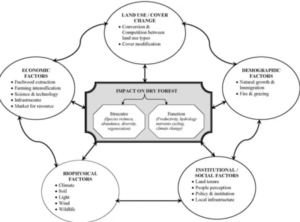
The conceptual framework represents a simplified version of land use change and process drivers (Fig. 1). The effects of each major driver and process are reviewed below. Since the biophysical factors cross-cut the various drivers, they are reviewed within each driver and process, as deemed relevant.
Figure 1. The conceptual framework illustrating the relationship between major drivers of land use change and
1.3.1 Demographic drivers
The exact role of population growth as a major driver of environmental change is strongly debated (Veldkamp & Fresco, 1996; Ningal et al., 2008), with neo-Malthusian and Boserupian theories dominating the discussion (Perz et al., 2005; Perz et al., 2006). According to Malthus (1989), population growth is a function of agricultural productivity. This theory, supported by various authors, is founded on the potential for human population growth to exceed the capacity of the available resources to sustain it (Ehrlich, 1968; Norgaard, 2001). Indeed, population growth is considered as a major cause of increasing demands for food, fuelwood, fodder, and other ecosystem services. Furthermore, people often face additional challenges when population growth is recorded, including low economic growth and limited means of income generation outside the utilization of local ecosystem services. Conversely, the theory of Boserup (1965) suggests that agricultural development is a function of population increase, resulting in changes to production methods and improvements in land fertility. Hence, population growth is seen as a cause of prosperity, and agricultural intensification (changing agricultural methods to raise production concentration at the cost of more work at lower efficiency) is mainly due to technological improvements that sustain population growth. She formulated her theoretical understanding of the relationship between population growth and agricultural change on historical Europe. Due to periodic famines and plague in Europe prior to the 18th century, the population was not large enough for the long-term benefits of more intensive agriculture. For that reason, more intensive methods, such as irrigation, were used in a few more densely populated areas. Boserup asserts that agricultural intensification, or the gradual change towards patterns of land use which make it possible to crop a given area of land more frequently than before is an important mechanism for increasing production. In describing this development, she states that small sparsely distributed populations use the land intermittently, with heavy reliance on fire to clear fields and fallowing to restore soil fertility in the wide-spread practice of ‘slash and burn’ farming. However, rising population density requires production concentration (output per unit of land per unit of time) to rise and fallow times to shorten. Thus, a growing population can use land more frequently and increase output by substituting technological inputs such as fertilizer or irrigation for fallow to retain soil fertility. If Boserup’s theory holds, one can expect the degradation of forest quality due to wide-spread shifting cultivation practices when population is low, albeit better
potential for recovery of secondary forests on abandoned fallows. At higher population level, the practice of fallowing is negligibly existed, thus leading to permanent change of the forest cover or simply deforestation. This, in turn, results in loss of biodiversity. However, direct examination of these theories remains elusive, despite their importance, largely because of the complexity of human interventions and their various effects on ecosystems (Luck, 2007). Boserup depicted agricultural intensification as a universal process cross-cutting all environments, but her model relied heavily on agro-ecological features of fire and fallow that are hardly universal; i.e., the relationship between production concentration and efficiency (output: input) may be quite variable among environments. Social context affects both the demands for agricultural products and the relative efficiency of different production methods, which in turn vary culturally. Another important aspect missing in her model is the role external economic systems play in shaping agricultural change through its effect on the cost of inputs and value of output beyond local energetic. Above all the variation in farmers’ ability to intensify agriculture as they wish or totally resorting into another alternative to intensification (mainly migration) is totally overlooked. Bilsborrow (2002) developed an alternative approach based on demographic-economic responses to migration. This recent approach emphasizes cultural and political factors when assessing population impacts on the environment (Perz et al., 2005). Indeed, the importance of policy factors in land use change were illustrated by Veldkamp & Lambin (2001), who suggested that international environmental treaties, such as the Kyoto Protocol, may drive significant changes in global land use. This evolution of the land use concept has favored models that capture the inherent complexity of population dynamics more completely, while also allowing the analysis of future trends (Kummer & Turner, 1994; Veldkamp & Fresco, 1996; Stephenne & Lambin, 2001). For instance, the simulation model of land use change in the Sudano-Sahelian region (Stephenne & Lambin, 2004) identifies pastoral lands, together with natural vegetation and croplands, as the land use types that generate the population's basic resources. Nevertheless, Miles et al. (2006) reported that virtually all tropical dry forests are exposed to a variety of threats that are largely caused by human activities. Consequently, population growth and food production increases the pressure on ecological systems, and is a major environmental concern in tropical countries (Nagendra et al., 2004; Wright, 2005; Etter et al., 2006; Pacheco, 2006).
1.3.2 Institutional and social drivers
In addition to demographic driver, land use is affected by socio-cultural, policy and institutional issues. In attempts to understand the effects of culture as a driver of ecosystem change, it is useful to consider culture as the values, beliefs, and norms that a group of people share (Cotton, 1997). In this sense, culture conditions individuals’ perceptions of the world, influences what they consider to be important, and suggests appropriate or inappropriate courses of action. Nevertheless, cultural differences have important impacts on direct drivers (Nelson et al., 2006). For example, cultural factors can influence consumption behavior (what, and how much, people consume) and may therefore be a particularly important driver of environmental change.
Socio-political drivers are those forces that influence the decision-making process, and include the quantity of public participation, the make-up of participants in public decision-making, the mechanisms of dispute resolution, the role of the State relative to the private sector, and levels of education and knowledge. Where public involvement in decision-making is concerned, recent trends towards democratic institutions have helped to empower local communities, women, and resource-poor households. However, the relationship between a country and its position and role in the global economy (i.e. dependency theory) has also been connected to environmental degradation (Ehrhardt-Martinez, 1998). For instance, deforestation may result from three types of dependency: export/trade dependency, debt dependency, and an influx of foreign capital. Globalization has also been suggested to underlie those processes that affect tropical land use change through, for example, expansion and liberalization of the markets, and agricultural intensification (Diouf & Lambin, 2001). During the past two decades, international initiatives have greatly contributed to the evolution of the national environmental policies and institutional changes (Glicken, 2000; Benjaminsen, 2001; Pearce et al., 2003) throughout the world. However, in Francophone West Africa, the participatory and community-based forest management have not been able to dismantle a long tradition of forest management which separates rights and users into two distinct categories: the commercial for the citizens and Government, and the subsistence for the rural people (Ribot, 2001). In addition, institutional factors, such as land tenure and legislation, can lead to land use/cover changes in tropical countries (Feder & Feeny, 1991; Reid et al., 2000).
1.3.3 Economic drivers
Economic activity is the consequence of human efforts to improve the quality of life, the outputs of which are determined by natural resources (Nelson et al., 2006). Although land use practices vary greatly across the world, the ultimate intention is generally the same; the acquisition of natural resources for immediate human needs, often at the expense of environmental conditions. By clearing tropical forests, practicing subsistence agriculture, intensifying farmland production, or expanding urban centers, anthropogenic activity is changing the world’s landscapes in pervasive ways (DeFries et al., 2004). Globally, croplands and pastures are the largest biome on the planet, covering almost 40% of the land surface (Asner et al., 2004). Many land use practices, such as fuelwood collection, livestock grazing and road expansion, can degrade forest ecosystems in terms of productivity, biomass, stand structures, and species composition, irrespective of whether such practices actually change the forested area (Foley et al., 2005). Furthermore, agricultural expansion is generally recognized as the primary economic driver of land use/cover changes in African dry ecosystems (IPCC, 2001; M.A., 2003; Carpenter et al., 2006). Commercial woodfuel extraction adds into the economic drivers of land use change, particularly in big town or city neighborhoods (Arnold et al., 2006). Overall, the growth in human and animal populations, which in turn increases demand for food and forage crops, drives the expansion of cropland and pastoral land, respectively. Kuznets (1955) has developed an alternative view of economic growth as a driver the environmental degradation in the developing countries, with a so called “Environmental Kuznet’s Curve”. According to this principle, poverty and rapid population growth may result on negative effects on the environment during the early stages of economic development, but this trend will be counteracted by later environmental quality improvements as incomes and living standards improve. However, Darkoh (2003) pointed out the necessity of appropriate interventions such as soil conservation measures and land-use policies, to prevent the inevitable degradation of land that will rise. Using cross-section data of protected areas for several countries, Dietz & Adger (2003) did not find an environmental Kuznet’s curve for species richness, and found that the conservation of biological diversity is a multi-faceted issue with spatial and cultural differentiation, confirming the complexity of the relationship between income per capita and environmental quality.
1.4
Effects of land use change
1.4.1 Effect of land use change on species diversity
Biodiversity conservation has gained global importance since the 1992 United Nations Conference on Environment and Development (UNCED). Biodiversity can be defined as the variety and variability among living organisms and the ecological complexes in which they occur (Darkoh, 2003). It is now a central issue in sustainable development due to the growing awareness of its importance for human survival and economic security, and the massive reduction in biodiversity that is anticipated to result from human activities (Forester & Machlis, 1996; Singh, 2002; Trombulak et al., 2004).
Human consumption patterns have exceeded the earth’s production capacity since the mid-1970s, and the demand for energy, food, and forest products continues to increase (Meffe et al., 2005). This increased pressure has resulted in 83% of the earth’s surface being affected by human activities, and related threats to biodiversity can be grouped as follows (Groom, 2005): habitat degradation, overexploitation causing local or global extinction of species or populations, invasive species threatening the dynamics or abundance of native species, and reductions in species diversity. Furthermore, poverty compromises the ability of people to conserve biodiversity in many developing countries. If current trends in global population density and growth continue, the increase in habitat degradation will instigate a 35% level of species extinction in Afrotropical zone species and an 8 to 10% level globally, by 2050 (Groom et al., 2005).
There is a close correlation between biodiversity status or change (e.g. species richness, forest cover) in African ecosystems and the spatiotemporal variation in human population density. This suggests that increases in population density may amplify threats to biodiversity (Wright & Muller-Landau, 2006; Cordeiro et al., 2007; Luck, 2007). Dry forests contain important and valuable resources, such as timber, medicinal substances, industrial materials and services (e.g. soil conservation, flood control, water supply), which are being reduced at an increased rate through deforestation mediated by population growth (Maass, 1995; Laurance, 1999; Darkoh, 2003; Foley et al., 2005). Three types of population-linked factors have been identified as contributors to dry ecosystem deforestation: changes in cultivation by local people,
spontaneous settlers (i.e. agribusiness actors), and government resettlement projects (Thapa & Weber, 1990), although the latter is not the case in West Africa. The conversion of dry forests to agriculture and pasture is occurring rapidly and causes significant destruction of forest structure and composition, while disrupting ecosystem functions. Furthermore, such high impacts on forest cover can alter the local or regional climatic conditions, in particular leading to decreases in rainfall (Charney et al., 1975) and increases in erosion and/or runoff and temperature (Maass, 1985; Lal, 1990). However, several studies in the Sudano-Sahelian zones have revealed the complexity of local land use situations, which are often difficult to predict and therefore need more investigation (Warren, 2002; Wardell et al., 2003; Burgos & Maass, 2004).
1.4.2 Impact of land use change on dry forest recovery
Forest cover in tropical areas is generally built up through natural processes, in which plants are replaced or re-establish by seed production (sexual reproduction) and/or asexual or vegetative reproduction (Bellefontaine, 2005b). Tree regeneration processes can be influenced by several seed-related factors, such as dispersal modes, viability, dormancy, and predation (Teketay, 1997; Condit et al., 2000; Khurana & Singh, 2001). In addition, tree regeneration can be influenced by various environmental factors, such as soil moisture, temperature, micro-scale disturbance, canopy cover, wind direction and speed, and slope gradients (Yamamoto, 2000; Ceccon et al., 2006; Vieira & Scariot, 2006). Biotic factors, such as herbivory and intra/inter-specific competition (for water, nutrients and space), can also influence seedling dynamics (Nagamatsu et al., 2002; Picard & Bar-Hen, 2002; Dembele et al., 2006). Many dry ecosystem species are characterized by asexual reproduction, which is generally induced by disturbances like fire, herbivory, and cutting (Bellefontaine, 1997; Gignoux et al., 1997; Bellefontaine et al., 2000; Sawadogo et al., 2002; Bationo et al., 2005; Bellefontaine, 2005a). Changes in human activities (e.g. conversion between land use types and changes in disturbance regimes, such as wood cutting, fire or grazing) may also directly or indirectly affect the regeneration of species (Scholes & Walker, 1993; Menaut et al., 1995; Kennard et al., 2002; Hoffmann & Solbrig, 2003). However, not much is known about the interrelationships of these abiotic, biotic, and anthropogenic factors, particularly in the Sudanian dry forests. Therefore, understanding natural regeneration and the pattern of population distribution is crucial when examining forest growth and
composition (Tesfaye et al., 2002; Ceccon et al., 2006), and when attempting to develop appropriate guidelines for regional restoration programs.
1.4.3 Impact of land use change on climate
The most pressing issues in global change are land cover and climate changes, with anthropogenic land modification and conversion being the predominant contributing factors (Turner II et al., 1993). Land use and cover influence biogeophysical, biogeochemical and energy exchange processes (Hulme, 1996; IPCC, 2001), and variations in these processes affect local, regional, and global climate patterns. Key processes include: uptake and release of greenhouse gases by the terrestrial biosphere through photosynthesis, respiration, and evapotranspiration; the release of aerosols and particulates from surface land cover perturbations; variations in sensible heat exchange between the surface and atmosphere due to land cover changes; variations in absorption and reflectance of radiation, as land cover changes affect surface reflectance; and surface roughness effects on atmospheric momentum that are land cover-dependent. Human activity can and does alter many of these processes and attributes, but weather and climate, as well as geological and other natural processes, are also important. For example, factors that cause land-cover changes, e.g. forest fires, alter ecosystems and release carbon dioxide, methane, carbon monoxide, and aerosols to the atmosphere. They also change land surface reflectivity, which determines how much of the sun’s energy is absorbed and available as heat, while vegetation transpiration and surface hydrology determine how this energy is partitioned into latent and sensible heat fluxes.
Studies on land use and cover provide critical information for the large-scale assessment of vegetation biomass and forest cover, which are key components of the carbon cycle. Goals for future studies of land use and cover change include the acquisition of very accurate biomass estimates for refining knowledge of carbon storage in vegetation; the understanding of regional land use changes that affect biomass; and the quantification of links and feedbacks between land use and cover change, climate change, and other related anthropogenic and environmental processes. The global climate and carbon storage processes are impacted by changes in forest cover, particularly those occurring in the tropics. However, the pattern of land use change is characterized by large variations between regions (Laurance, 1999).
1.5
Participatory management of forests
Participatory approaches in strategic planning and forest policies were adopted relatively recently (in the 1980s) in developing countries compared to the traditional forest conservation management, and have become a central decision-making tool (Buttoud, 1999). Forest conservation generally used to be achieved through formally designating certain areas as reserves or protected forests. However, conserving forest diversity in the reserves, although crucial for credible conservation strategy, is not sufficient for protecting all the diversity because 92% of world’s forests are outside formally protected areas (Lindenmayer et al., 2006; Boffa et al., 2008). This traditional conservation model of “National Parks”, pioneered in the USA, has been replaced by the new approach of “participatory conservation” for several reasons. First, this approach is based on the recognition of the local communities’ rights and increased integration of traditional knowledge and views in conservation policies (Colchester, 2004). Traditional ecological knowledge has become relevant to contemporary sustainable resource management, understanding complex systems, and solving emerging issues like global and climate change (Ford, 2000; Sen, 2005). Local knowledge of species decline and/or conservation is increasingly considered in forest conservation strategies (Lykke, 2000; Ouinsavi et al., 2005), and even in rangeland and livestock forage plant management (Farooquee et al., 2004), as it is acquired over long periods of time, and such observations are important sources of information when developing sustainable management practices for natural resources in general (Stringer & Reed, 2007), and forest ecosystems in particular (Shrestha & Dhillion, 2003; Ssegawa & Kasenene, 2007; Tabuti & Mugula, 2007). Environmental NGOs have especially contributed to the advancement of local knowledge in international initiatives, such as the Convention on Biological Diversity (Dumoulin, 2003). Second, a remarkable attention has been given to the role of forests and forestry in poverty reduction strategies in recent years, as one aspect of the Millennium goals (UNDP, 2003). In general, forests and the forestry sector can contribute to poverty reduction by addressing subsistence and vulnerability, income generation, energy, as well as agricultural and rural development. In many developing countries, there is a high dependence of people on forest resources for multiple uses (Bergeret & Ribot, 1990; Lykke, 2000; Ræbild et al., 2007) however this dependence may be crucial particularly for the very poor or landless farmers who often consume wild products to meet their daily subsistence needs and to reducing the vulnerability to external shocks (attenuate the need of consumption in time
of food scarcity (Ganemtoré, 2002)). Products derived from forests and trees are important sources of cash income and employment for the rural poor. An estimated 15 million people in Sub-Saharan Africa earn cash income from forest related activities, which are important especially for the most vulnerable groups including women and children (Oksanen & Mersmann, 2003). Numerous are those that use or sell wood as main source of energy. In Sub-Saharan Africa, an estimated 70 – 90% of the population relies on fuelwood and charcoal for energy. Forests and trees contribute to crop and livestock production by providing soil nutrient and animal fodder, averting soil erosion while maintaining water supply, and regulating weeds and pests, which are especially important for poor farmers working in marginal environments as most of them have no access to improved farming inputs.
These twin objectives – biodiversity conservation and poverty reduction – can be effectively achieved by devolving ownership and management of forest resources to local communities, lifting excessive regulations over the use of forest resources, and increasing the political capital of the poor, which are the essence of participatory forest management. FAO (2001) highlighted the guidelines to allow the benefits to local livelihoods from people-centered forestry to include rights to access, control and use of forest and tree resources; more say in decisions over use and management of forest resources; reduced vulnerability, not only through secure forest resources but also political empowerment; income from forest goods and services; improved governance though more effective local institutions; partnership to enhance capacities; direct benefits from environmental services; and increased powers of negotiation.
The participatory approach of natural resource management and the concept of decentralization reforms in West Africa took place over the last two decades (Ouedraogo, 2004). These reforms aimed to improve local management and development by transferring management responsibility and powers to local institutions (Ribot, 1999; Hermosilla, 2000). However, suitable conditions for more equitable and efficient management have not yet been established in Africa (Ribot, 2003; Anderson et al., 2006) and the real incorporation of the local communities’ priorities remains questionable (Ribot, 2001; Mwangi & Dohrn, 2008). During the last 15 years, several projects in forestry (80) have been initiated in Burkina Faso in cooperation with FAO, mostly focusing on fuelwood exploitation from the natural forests with local communities’ participation (MECV, 2004). The results
obtained in some forest exploitation areas by the project "Regional Program for the Traditional Energy Sector" - RPTES (from 2001 to 2004) are encouraging and in contrast with previous view of over-exploitation of Burkina natural forest (Ouédraogo & Nianogo, 2005). In some forest exploitation areas, such as Bougnounou-Nébielianayou, located in the southern region of Burkina Faso, local capacities were improved in all aspects of the management including fire control, direct seedling, reforestation, extraction techniques, exploitation of non-wood products, and restoration of degraded soils. More generally, these experiences demonstrate that natural forest exploitation in Burkina can contribute to poverty reduction strategies through income generation and their diversification (exploitation of wood, raising, apiculture, fishing, market gardening) for the benefit of poor people (Ouédraogo, 2005; Ouédraogo & Nianogo, 2005).
1.6 Forest management and land use issues in
Burkina Faso
In Burkina Faso, dry forests cover ca. 6,794,000 ha, representing 25% of the total land area and 48% of vegetation cover (FAO, 2006). Some of these forests are located in protected areas, such as national parks, fauna reserves, and classified forests or forest reserves, which collectively account for 27% of the country's total vegetation cover. Some clusters of dry forests are also located in the densely vegetated non-protected areas of the south-western part (Fontes & Guinko, 1995). Management of forests and woodlands in West Africa has been influenced by the political and environment histories of the region. In Burkina Faso, it is dated back to the colonial era. During this time, all forests and wooded areas and their rich fauna were open for exploitation by the local people to satisfy their basic needs in accordance with their customs. Restriction rose following the establishment of state classified forests in 1935 by the colonial power, with a status of total protection. The protected areas delineated were used as wildlife sanctuaries to prevent forests from being converted to cropland and its expansion (Shepard, 1992; Bellefontaine et al., 2000). The policy of total protection was based on the assumption that nature has the capacity of self regulation of natural disturbances, and therefore actions that can harmfully exceed this regulation capacity were forbidden. The severe Sahelian drought of the 1970s revealed the limitations of this approach and measures of soil and water conservation emerged in the northern part severely affected by the desertification. The importance of the
environmental issue is illustrated in the National Plan to Combat the Desertification of 1996: "The struggle against the desertification in a country as Burkina Faso, whose economy is essentially based on agriculture and husbandry, is not only a simple question of an ecologist vision, but instead a question of survival". This regulation was characterized by a dualism between citizens and rural people in the control and management of the forests. Under this separation, forest services and the elite typically gain the rights to harvest, transport and market valuable forest products, while the poor rural dwellers can access forest products with little or no commercial value (Ribot, 2001).
As in many countries of Francophone West Africa countries, the forestry sector in Burkina Faso was characterized by a lack of notable attention from the decision-makers for several decades after the independence (1960s). The development priorities were given to agriculture, and forest products were considered as picking-gathering products because of their low economic value (Nouvellet, 1993). Large-scale plantation projects initiated after the drought of the 1970s to provide fuelwood to the urban cities, but were not successful due to prohibitive cost and a lack of involvement of local people (Ouedraogo, 2001; Zida, 2007). With the development of village forestry in 1980s, the rural people stated to involve in the environment protection activities through tree planting, soils conservation, agroforestry improvement, construction of wind breaks and the use of improved stoves. During this time, the participatory approach to forest management emerged based on the involvement of local communities, which was more promising than the former top-down approach (Ouedraogo, 2002; Ouedraogo, 2003a; Kaboré, 2004). In the 1990s, under international initiatives (e.g. UNCED, the CBD, the CSD, Agenda 21, Helsinki and IITO and Dry Zone Africa processes) forests policies were revised and oriented towards sustainable development and biodiversity conservation (Glicken, 2000; Kaboré, 2004). In line with the recent evolution of environmental concept, most of the protected areas were managed mainly for provision of basic needs such as energy wood, environmental benefits (biodiversity conservation, wildlife), and curtailing forest degradation (Bellefontaine et al., 2000). The forest policy evolution was characterized by various legal dispositions directly or indirectly linked to forestry sector, including the Agrarian and Land Act, the Decentralization process, the Program Framework for management of national heritage, the National Program of rural land and territory management (i.e. PNGT), the Environmental Code, the National Program
of Forest management, the Forestry Code, the National Plan of Action for Environment, the Strategic plan for the scientific and technological research, the Integrated Rural Development Plan, the various National Plans of Action to Struggle against the desertification, Several National Strategic plans (e.g. for Biodiversity conservation, Climate change, Sustainable development and Poverty reduction). In the elaborated action plans, technical, political and legal aspects of natural forest management for the protected forests were incorporated, which includes the regulation of disturbance factors such as fire, tree cutting and livestock grazing, and also local communities efficient participation (Ouedraogo, 2003a; Kaboré, 2004; Zida, 2007).
As in many areas of West Africa, forest ecosystems of Burkina Faso are still subjected to common disturbances (e.g. agricultural clearing, wood extraction and grazing), which are exacerbated by human population growth (Attwell & Cotterill, 2000; Wezel & Lykke, 2006; Morton, 2007). Annual rate of deforestation in Burkina Faso is estimated as 0.35% per annum (FAO, 2006). In addition, forest reserves and national parks are not very well protected, leading them to be considered as 'paper parks' (Myers, 1994). The strong dependence of rural households on forests for croplands, grazing, and firewood, together with demands from cities for wood energy, is exacerbating pressures on the forests (Forester & Machlis, 1996; McKee et al., 2004; Neke et al., 2006). These pressures are amplified by migrant farmers who find these areas suitable for agriculture (Boutillier, 1985; Camp, 1992; Henry et al., 2003; Ouedraogo, 2003b). The migration zones of Burkina Faso are also subject to increasing pressure from livestock breeding leading to new territorial construction between various actors (Botoni, 2003; Augusseau et al., 2004)In the southern region of the country, where human pressure is accelerating forest degradation, institutional weaknesses are additional contributors to forest reserve deterioration (Ouedraogo, 2003a). Forest degradation, in turn, negatively affects the livelihood of rural people (Darkoh, 2003), and thus the forested zones of Burkina Faso need sustainable land management policies. Such management requires detailed knowledge of land use patterns; the structure, composition, and regeneration capacity of the existing forests. Also traditional local knowledge of plant use and resource management can be efficiently incorporated into sustainable land management policies, therefore, improving our understanding of the complex socio-economic and biophysical factors involved in land use dynamics and assisting in an informed decision-making on sustainable forest ecosystem management and biodiversity conservation in the region.
2
Objectives
The general aim of the work presented in this thesis was to gather information on land use change and its implication on the conditions of the Sudanian dry forest. The knowledge gained will hopefully support sustainable forest management and biodiversity conservation in the region. Specifically, the various studies presented in this thesis addressed the following questions:
1. Did the extent of the various land use types change over the last 16 years? What was the impact of this land use dynamics on the condition of the Sudanian dry forest in Southern Burkina Faso? (Study I);
2. Given a large decrease in forest cover in the region, does designation of protected areas ensure conservation of tree diversity under different human pressure situations? (Study II);
3. Again given a decline in forest cover, do conservation status of the dry forest and the extent of human pressure favor the regeneration and spatial distribution of tree seedling populations differently? (Study III);
4. Do the local people and various stake-holders perceive the decline in the dry forest in the region? What measures do they recommend to circumvent the current trend and better manage the forest? (Study IV).
3
Materials and Methods
3.1
Study sites
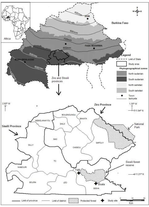
The first study was conducted in Sissili and Ziro provinces (11°02’-12°00’ N and 01°30’- 2°80’W), study IV in Sissili province alone, and studies II and III in the district of Bieha (Boala and Yale villages) located in Sissili province. All sites are located in the southern region of Burkina Faso, West Africa (Fig. 2). The area is characterized by low relief with an average altitude of 300 m a. s. l. and consists primarily of settlements, cultivated lands, open savanna woodlands, and clusters of dry forests. Phytogeographically, the study sites are situated in the Sudanian regional centre of endemism in the south Sudanian Zone (White, 1983). The vegetation includes protected and unprotected forests; the former are legal gazetted, such as Sissili protected forest and Kabore Tambi national park while the latter encompass forest formations around the villages, including secondary forests on fallows and parklands. The park and ranch of the region contain a rich fauna essentially composed of elephants, buffalos, springbuckk, waterbuck, warthogs, monkeys, hyenas, crocodiles. The flora of the region is dominated by perennial grass species such as Andropogon gayanus Kunth, A. ascinodis C.B. Cl, and Schizachiryum sanguineum (Retz) Alston (Fontes & Guinko, 1995). The ligneous species are represented mostly by Afzelia africana Smith ex Pers, Khaya senegalensis (Desv.) A. Juss and Pterocarpus erinaceus Poir which are important fodder species. The occurrence of scattered trees of species like Vitellaria paradoxa Gaertn. f., Parkia biglobosa (Jacq.) R. Br ex G. Don. and Tamarindus indica L. on croplands (often known as parklands) is also a common feature of the study area. The climate is dry tropical with a unimodal rainy season lasting from May to October (National Weather
Forecast Center). The mean (± SE) annual rainfall for the years 2000-2003 was 875.6 ± 26.0 mm, with 55 ± 2 rainy days per annum. The average annual temperature was 28°C, with a maximum average monthly temperature of 37.9°C in April and a minimum average monthly temperature of 17.6°C in December.
Most frequently encountered soils are Lixisols (tropical ferruginous soils), poorly to fully leached, overlying sandy, clayey-sandy and sandy-clayey material (Driessen et al., 2001).
The dominant agricultural system in the study area is traditional subsistence farming with cereals (such as sorghum, millet, and maize) and tubers (yam and sweet potatoes). Since a decade ago, there is a high competition between this traditional farming system and a more lucrative productive system: fuel wood extractions, cultivation of cash crops (with cotton and fruit-tree plantation) and ranching. In addition, rural migration is currently increasing the population density in the region, leading to an increase in pressure on the natural resources by various ethnic groups. The population is constituted of native ethnic group of Nouni, and migrant groups composed mainly of Mossi (originating from the centre and northwest of Burkina Faso), and Fulani (originating from northern Burkina Faso). The average population density is 30 inhabitants/km2 in Sissili and
33 in Ziro province.
Like in other rural areas, the Gurunsi territories are ruled by traditional authorities composed of two chiefs (the chief of village and the chief of land ownership and traditional divinity). Although their power is being progressively weakened by the modernization process, the traditional social structures are still involved in all important decisions within the village territory and are solicited extensively for problem-solving of social conflicts, access to land and natural resources, or local administration issues, implementation of the development or conservation projects, plans or programs at local scale (MED, 2005).
3.2 Methods
3.2.1 Study I
The first study assessed the land use changes at regional (Sissili and Ziro provinces) and local scales (Boala and Yale villages) over a period 16 years and its impact on the forest ecosystem. For this purpose, two satellite images from 1986 and 2002 were visually interpreted and processed to map land cover changes. The basic data source was Landsat satellite images (TM and ETM+): Path195 and Row 52 from November 1986 and October 2002, with 30 m spatial resolution. For the local scale analysis, aerial photographs from 1984 and 1997 and the satellite image from 2002 were
visually interpreted. To assess disturbances in the forests, a systematic stratified sampling design was applied where the protected and unprotected forests within a village were demarcated first, and then systematically sampled by laying circular plots (55 m radius) on grids. In Yale, the plots (91) covered 0.9% of the protected area of the village, and the same in the remaining unprotected area. In Boala, the plots (66) represented 1% of the total area of the village. The assessment included number of stumps of trees cut for fuelwood and local construction, number of trees pruned for animal feed, number of trees uprooted by elephants and the percentage of the plot with indicators of grazing (animal trails, hoof print and herbage removal). For both cases, additional secondary data sources (i.e. administrative, topographic and forest maps) were used, as well as ground control information.
3.2.2 Studies II & III
The second and the third studies examined the diversity of woody vegetation (II) and natural regeneration (III) in relation to forest conservation status (protected versus unprotected) and human population density (serving as proxy for human pressure) at two villages, Boala (14 inhabitant/km2) and Yale (30 inhabitant/km2), located close to the Sissili
forest reserve. A stratified systematic design was applied where the study site was first stratified based on human pressure as low (Boala) and high (Yale) and then based on the conservation status as protected and unprotected forests. Sample plots were selected and laid using a vegetation map obtained by visually interpreting aerial photographs from 1997. The number of plots in each unit was proportional (1%) to the size of each forest. Hence, a total of 127 circular plots (each with a 12 m radius) were used for collecting data on vegetation attributes. Species were identified in situ and nomenclature of species followed Arbonnier (2002).
In study II, all woody individuals that had a diameter ≥ 2.5 cm at breast height (dbh) and a height > 1.5 m were counted in each plot. These size classes enabled us to include individuals of short stature, which are typical of dry forests/woodlands. Disturbance indicators (e.g. lopping, cutting, and elephant damage) were also recorded at each plot in order to determine the extent of such damage. The relative ecological importance of each woody species and each family were expressed using the importance value index (IVI) and family importance value (FIV), respectively (Heikkinen & Birks, 1996; Galeano et al., 1998). A variety of diversity indices were calculated in order to permit a more precise comparison of the alpha diversity in each
forest type (Magurran, 2004). To compare diversity between forest types, β-diversity was calculated using Jaccard´s coefficient of similarity and Horns’ modification of Morisita´s index of similarity.
In the third study, woody individuals with a diameter at breast height (dbh) < 2.5 cm and below 1.5 m of height were recorded and considered as seedlings. The seedling species composition in the protected and unprotected forests at each site was compared using Sorensen’s similarity index (Krebs, 1999). The spatial distributional patterns of the seedling populations within the different sites and forest conservation types were analyzed using the standardized Morisita's index of dispersion (Ip), since it is relatively independent of population density (Krebs, 1999).
3.2.3 Study IV
The fourth study reports on an investigation of the utilization of tree species by local people, their perceptions of changes in the surrounding forests, and suggested solutions in the Sissili province of southern Burkina Faso. A combination of participatory rural appraisal, household interview and observational methods were used to collect the data. A participatory approach was implemented to gather information on the peoples' perception of forest resource dynamics in the region by holding an opinion-exchange meeting at Leo (the provincial city) in August 2003, with the participation of three groups of stakeholders. These included a group of 17 grass-root actors (villagers from Boala and Yale and ranch managers), a group of 22 decision-makers (delegates from the Environment, Animal Resources and Agriculture Ministries and the Ministries’ district and provincial offices) and finally a support group of six persons composed of delegates from NGO, the National Program of Land and Territory Management, the local cotton company and the training and extension officers. The information collected was related to the local natural resources, including forests and arable lands. The participants were asked to address the following specific questions. What is your understanding of land use changes around the two villages and the current condition of the forest ecosystem in Sissili province? What are the causes and consequences of these changes? What suggestions do you have for improving the management of forest resources?
Detailed information on local people's uses of woody species was obtained by conducting a household interview at Boala and Yale villages. Households were selected in which the head of the household was more
than 25 years old and had been resident in the village for at least 20 years at Yale and 10 years at Boala, assuming that people who satisfied these conditions were sufficiently qualified to provide accurate information regarding the use of species and forest dynamics. A sample size of 30% of eligible households was selected, which yielded 44 and 92 respondent households in Boala and Yale, respectively. The questionnaire was semi-structured, organized in seven sections: personal information, species present in the parkland and their dynamics, uses of the different species, the parts of plant used, product extraction modes (cutting, collection or pruning), location of their extraction sites (field, fallow or the forest), and observations on vegetation changes.
3.3 Data analysis
Land use data, as well as data from the interviews and field assessment were analyzed using descriptive statistics (study I). ANOVA was performed to examine whether conservation status and human population density affected the calculated diversity indices (study II) and the seedling richness and density (study III). The magnitude of any significant effects was determined by a statistic called partial eta squared (ηP2), and the effect
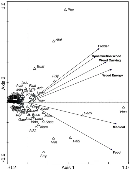
was considered to be small, moderate or large if the value of this statistic was 0.01, 0.06 or 0.14 respectively (Cohen, 1988). Curve-fitting was used to find the best function for describing the relationship between seedling and adult tree densities (study III). Principal Component Analysis (PCA) was carried out on species-seedling density and species-frequency of occurrence in sample plots to examine the regeneration conditions at individual species level (study III). PCA was also performed on species-use and plant parts-use matrices (study IV). The statistical analyses were performed using SPSS 15 software (Copyright SPSS for Windows, Release 2006. Chicago: SPSS Inc) and PCA using the software package CANOCO 4.5 and the ordination diagrams drawn in CANODRAW (ter Braak & Smilauer, 2002).
4
Results
4.1
Land use change and its drivers
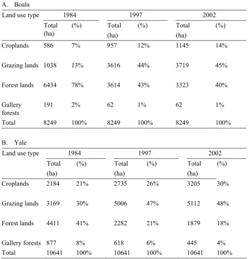
The assessment of land use change over a 16-year period showed that the trend was similar between the villages, although the magnitude of land use change differed. In both villages, cropland and grazing areas increased at the expense of decreasing forestlands (Table 1). The size of the forest land was diminished nearly by half in 2002 compared to its coverage in 1984, while the size of the gallery forest did not change much. In Yale, the size of croplands and grazing lands increased by 9% and 18% in 2002 compared to the sizes in 1984, while the forest land and the gallery forests declined by nearly 50% (Table 1). Locally, the annual rate of conversion to cropland was estimated at 0.4% to 0.5%.
At the regional level, the various land use types included extensive grazing areas, pastoral management units, subsistence and commercial agriculture, protected forests, and production forests mainly for fuelwood extraction. The actual size and proportion of the different land use types changed during the study period. In 1986, the grazing land had much higher proportion of the total regional area than other land use types while the size of croplands was substantially higher after 16 years (Table 2). The size of other land use types decreased during the study period; particularly the decrease was more notable in the gallery forest and grazing land. Interestingly, the annual conversion rate to croplands varied among districts within provinces. In Ziro province, the lowest conversion rate was observed in Cassou (0.1%) and the highest in Bougnounou (1.3%). In Sissili province, the lowest and highest conversion rates were observed in Silly (0.3%) and Niabouri (1.5%) districts, respectively.
Table 1 Land use change at a local level for the period 1984-2002
A. Boala
1984 1997 2002
Land use type
Total (ha) (%) Total (ha) (%) Total (ha) (%) Croplands 586 7% 957 12% 1145 14% Grazing lands 1038 13% 3616 44% 3719 45% Forest lands 6434 78% 3614 43% 3323 40% Gallery forests 191 2% 62 1% 62 1% Total 8249 100% 8249 100% 8249 100% B. Yale 1984 1997 2002 Land use type
Total (ha) (%) Total (ha) (%) Total (ha) (%) Croplands 2184 21% 2735 26% 3205 30% Grazing lands 3169 30% 5006 47% 5112 48% Forest lands 4411 41% 2282 21% 1879 18% Gallery forests 877 8% 618 6% 445 4% Total 10641 100% 10641 100% 10641 100%
Table 2. Regional land use dynamics in Sissili and Ziro provinces, southern Burkina Faso
during 1986 to 2002
1986 2002 Land use type
Area (ha) (%) (ha) (%) Annual change (%)
Forestlands 209561 17 197747 16 -0.38
Grazing lands 738176 60 632828 51 -0.88
Gallery forests 75949 6 55919 5 -1.63
Croplands 213414 17 340606 28 +3.75
The main drivers of land use change at local and regional scale were increase in human population, change in farming system and infrastructure development. There was an increase in population at both regional and local levels during the study period. At a regional scale, the annual rate of increase in population density was 3.3% with remarkable variation within district (from 1.8% to 9%). At a local level, there was also a similar increase in population with distinct difference in population density between the villages during the period 1985-2002. At Boala the influx ranged from 5 to 7 inhabitants/sq km while at Yale the corresponding values were 23 to 30 inhabitants/sq km.
The farming system was characterized by large scale commercial farming and subsistence farming (in the form of shifting cultivation and only for household consumption). Large size farming of commercial crops, such as cashew nuts, maize and beans, was found in seven districts within the region with varying land size; the highest being in Cassou (1228 ha) and the lowest in Bakata (120 ha). Cutting for fuelwood and local construction was a common disturbance on crops in Boala while it was common on grazing lands in Yale. Pruning of branches and grazing influence was largely observed on grazing lands in both villages while elephant damage was disproportionately higher on forest lands in Boala than Yale.
4.2 Structure and diversity of Sudanian dry
forest
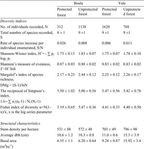
A total of 69 species, representing 52 genera and 26 families were found; 59 species across 48 genera were found at the site with high population pressure (HHP), while 58 species across 43 genera were recorded at the low population density (LHP) site. ANOVA revealed no significant differences in species richness between sites differing in population pressure or forest conservation status, nor was the interaction significant (Table 3).
The species abundance patterns displayed that the majority of the tree species were represented by a few individuals, while only a few species were represented by many individuals. ANOVA revealed that Shannon’s measure of evenness was significantly higher at the less populated site than the highly populated site (F[1, 122] = 6.22; p = 0.014; ηp2 = 0.048). The
moderate effect, for Fisher’s diversity index (F[1, 122]= 5.73; p = 0.008; ηp2 =
0.045) being significantly higher in unprotected forests.
Table 3. Tree diversity measures and structural attributes for protected and unprotected
forests in sites with low (Boala) and high (Yale) human population pressure in southern Burkina Faso Boala Yale Protected forest Unprotected forest Protected forest Unprotecte d forest Diversity indices
No. of individuals recorded, N 312 1138 1620 788 Total number of species recorded,
S
8 ± 1 9 ±1 9 ±1 9 ±1
Rate of species increase per individual enumerated, S/N
0.026 0.008 0.006 0.011 Shannon-Wiener index, H’= - ∑ pi
log2 pi
1.73 ± 0.13 1.83 ± 0.07 1.75 ± 0.07 1.78 ± 0.10 Shannon’s measure of evenness,
J’=H’/lnS
0.87 ± 0.03 0.88 ± 0.02 0.83 ± 0.02 0.83 ± 0.02 Margalef’s index of species
richness, DMg = (S-1)/lnN
2.17 ± 0.23 2.44 ± 0.12 2.25 ± 0.12 2.26 ± 0.17
The reciprocal of Simpson’s index,
1/λ= ∑ ni (ni-1) / Ni (Ni-1)
5.50 ± 1.02 5.00 ± 0.56 5.47 ± 0.56 5.42 ± 0.78
Fisher index of diversity α=N(1-x)/x, x is the log series parameter
3.19 ± 0.65 5.47 ± 0.36 4.41 ± 0.33 4.40 ± 0.50
Structural characteristics
Stem density per hectare 531 ± 88 572 ± 48 703 ± 49 796 ± 90 Average dbh (cm) 10.6 ± 1.2 10.3 ± 0.8 11.0 ± 0.6 15.3 ± 3.9 Basal area
(m2ha-1)
6.55 ± 1.1 6.20 ± 0.64 9.28 ± 0.87 15.92 ± 3.4
There was also a moderately significant interaction effect of human population pressure and conservation status on Fisher’s diversity index (p = 0.017; ηp2 = 0.045). In contrast, no significant differences were seen due to
population pressure, conservation status, or their interaction for either Shannon-Wiener’s index, the reciprocal of Simpson’s concentration index, or Margalef’s index of tree species richness. The comparison of species similarity (using Jaccard’s index) between forests types associated with the two sites showed a fairly low similarity between protected and unprotected
forests, with 59% and 49% similarity in HHP site and LHP site, respectively. A higher similarity, 66% and 82% for Jaccard’s and Morisita’s indices, respectively, was observed between the unprotected forests of both sites. In the protected forests, V. paradoxa (IVI= 44.28%) and Crossopteryx febrifuga (Afzl. ex G. Don) Benth. (IVI= 38.46%) stood out as the most abundant species at the site with LHP, while Detarium microcarpum Guilt. & Perr. (IVI= 53.35%) and V. paradoxa (IVI= 59.47%) were the most common species in HHP site. Other common species to both forest types were Burkea africana Hook. f. and Terminalia avicennioides Guilt. & Perr. The rarest species in the protected forests of both sites was Terminalia glaucescens Planch., which accounted for 0.81% of the IVI in LHP site and 0.21% in HHP site. The relative FIV revealed that Combretaceae (FIV= 122.89% and 92.52% for the protected and unprotected forests, respectively) was taxonomically diverse and constituted the largest group at LHP site irrespective of conservation status. This family was followed by Rubiaceae in the protected forests and Caesalpiniaceae in the unprotected forests. At the HHP site, Combretaceae was the most specious family in the protected forests, and was followed by Caesalpiniaceae. Other families with relatively high FIV values were Mimosaceae, Anacardiaceae, and Sapotaceae, the latter of which was solely represented by V. paradoxa.
A total of 1499 individual trees/ha with a dbh ≥ 2.5 cm and a height > 1.5 m were recorded at highly populated site, while 1103 trees/ha were found at the less populated site; the corresponding values for the basal area were 25.2 and 12.8 m2/ha (Table 3). The mean stem density was
significantly higher at HHP site than LHP site (p = 0.004), and the magnitude of this effect was moderate (ηp2 = 0.066). Basal area was also
significantly greater at HHP site (p < 0.001), and this effect had a relatively large magnitude (ηp2 = 0.107). There was also a significant interaction of
small magnitude between site and conservation status on the mean basal area (p = 0.044; ηp2 = 0.032). The dbh class distribution in the two sites
exhibited a similar pattern for each forest type, and the dominant class was comprised of individuals with 5-10 cm dbh. However, the pattern of the dbh class distribution varied between the selected species and conservation status mainly for V. paradoxa, D. microcarpum and B. africana. The height class distribution displayed a negative exponential trend for each site and conservation status. The height of trees generally ranged between 2.5 and 10 m. The assessment of disturbance indicators revealed that the trees in both sites were affected by human impacts (lopping and cutting) and
damage by elephants. Damage incurred by elephants was found to differ between the sites (p = 0.004; ηp2 = 0.066; with a mean occurrence per plot
of 4 ± 1 and 1 ± 0 uprooted trees for LHP site and HHP site, respectively). A total of 28 endangered and vulnerable species of high conservation importance were identified based on the IUCN Red List of Threatened Species (IUCN, 2004) and their national conservation status.
4.3 Regeneration and spatial pattern of
seedling population
A total of 63 species, representing 23 families and 48 genera, were recorded as seedlings; 43 species representing 35 genera were found in the protected forest, and 56 species representing 44 genera were recorded in the unprotected forest (Appendix 1). The families with the highest number of species were Combretaceae and Caesalpiniaceae, which jointly accounted for one third of the total species richness of the study sites. These were followed by Rubiaceae and Mimosaceae, which together accounted for one third of the total seedling species recorded. D. microcarpum and V. paradoxa were the most frequently occurring species in both forest types. Both forest types were generally characterized by a low proportion (18%) of abundant species (those with, for example, > 40 individuals ha-1) and a
low frequency of occurrence; however, the proportion of abundant species was higher in the unprotected forests (19%) than in the protected ones (5%).
At plot level, ANOVA revealed that there was no significant effect of conservation status on the species richness of seedlings (p > 0.05) while human pressure decreased (F[1, 122] = 8.94; p = 0.003; ηp2 = 0.068) richness
after significant adjustment by the covariate, distance to forest edge (p = 0.008). The interaction between conservation status and site did have a significant effect on species richness of moderate magnitude (F[1, 122] = 6.01;
p = 0.016; ηp2 = 0.047). Species richness was slightly higher in the
non-protected forest at Boala than Yale. A comparison, using Sorensen’s similarity index, of the seedling population richness between the forest types of the two sites showed that plots in the protected area of Yale and the unprotected area of Boala had the greatest similarity in species composition. The unprotected forests of the two sites had the least similarity.