HAL Id: hal-00296963
https://hal.archives-ouvertes.fr/hal-00296963
Submitted on 26 Sep 2006
HAL is a multi-disciplinary open access
archive for the deposit and dissemination of
sci-entific research documents, whether they are
pub-lished or not. The documents may come from
teaching and research institutions in France or
abroad, or from public or private research centers.
L’archive ouverte pluridisciplinaire HAL, est
destinée au dépôt et à la diffusion de documents
scientifiques de niveau recherche, publiés ou non,
émanant des établissements d’enseignement et de
recherche français ou étrangers, des laboratoires
publics ou privés.
Towards a network of observatories in terrestrial
environmental research
H. Bogena, K. Schulz, H. Vereecken
To cite this version:
H. Bogena, K. Schulz, H. Vereecken. Towards a network of observatories in terrestrial environmental
research. Advances in Geosciences, European Geosciences Union, 2006, 9, pp.109-114. �hal-00296963�
www.adv-geosci.net/9/109/2006/ © Author(s) 2006. This work is licensed under a Creative Commons License.
Advances in
Geosciences
Towards a network of observatories in terrestrial environmental
research
H. Bogena1, K. Schulz2, and H. Vereecken1
1Agrosphere Institute (ICG-IV), Institute of Chemistry and Dynamics of the Geosphere (ICG), Research Centre Juelich, 52425 Juelich, Germany
2Computational Environmental Systems, UFZ – Centre for Environmental Research Leipzig-Halle, 04318 Leipzig, Germany Received: 23 January 2006 – Revised: 22 May 2006 – Accepted: 3 July 2006 – Published: 26 September 2006
Abstract. In order to address the challenges of global change, interdisciplinary research in terrestrial environmen-tal science is of great importance. Several environmenenvironmen-tal re-search networks have already been established in order to monitor, analyse and predict the impact of global change on different compartments and/or matter cycles of the environ-ment. Typically these environmental research networks have focused on specific research questions, and compartments, such as CarboEurope, FLUXNET and ILTER. In this pa-per, we propose the establishment of a network of terrestrial observatories, defined as a system consisting of the subsur-face environment, the land sursubsur-face including the biosphere, the lower atmosphere and the anthroposphere. Hydrological units will be used as the basic scaling units in a hierarchy of evolving scales and structures ranging from the local scale to the regional scale for multi-disciplinary process studies. Al-though terrestrial systems are extremely complex, the terres-trial component in most process-based climate and biosphere models is typically represented in a very conceptual and of-ten rudimentary way. Remedying this deficiency is therefore one of the most important challenges in environmental and terrestrial research, and we suggest that terrestrial observa-tories could be an important step towards a new quality in environmental and terrestrial research.
1 Introduction
In the course of the 20th century, the activities of mankind and their consequences extended over the whole planet Earth putting at risk present resources for life and jeopardizing the development possibilities of future generations (e.g. EEA, 2004; McCarthy et al., 2001). The intensity of these anthro-pogenic interferences affects the global biogeochemical
cy-Correspondence to: H. Bogena
cle in a dramatic way. Atmospheric trace gases and aerosols control the quality of our air and have a great impact on the radiation budget of the atmosphere. The composition and distribution of these substances in space and time con-tribute in a manner still not fully understood to regional and global climate changes. Land use and land cover changes as a consequence of new EU agricultural policies or the ex-tended sealing of urban areas will have a significant impact on biodiversity and the buffering capacities of soil systems. Chemicals introduced into the environment will also alter the functioning of ecosystems and affect water and food quality. In order to evaluate the effects of regional and global natu-ral and anthropogenic changes and to develop technological, political and economic instruments for control and regula-tion, a comprehensive knowledge of the environmental sys-tems, processes and feedbacks is required. In order to ad-dress theses challenges, interdisciplinary research in terres-trial environmental science is of great importance. In the sense of sustainable development, the focus must not only be on short-term applications, but the time lags of environ-mental processes must also be taken into account that only lead to serious impacts on human society in the course of decades.
The term global change is used to encompass these multi-ple environmental and ecological changes. Global change effects are expected to occur on a medium- (10 years) to long-term scale (100 years and more). Global change is ob-served in all compartments of the Earth’s system, e.g. the increased concentration of CO2and other trace gases in the atmosphere, global warming, changing weather patterns, the loss of ozone in the stratosphere, land system changes caused by social, demographic and economic forces, and the ef-fects on ecosystems (e.g. deforestation, species extinction, and neophytes) (GLP, 2005).
The scientific community has responded to these envi-ronmental changes by performing dedicated experiments (e.g. Knorr et al., 2005) and by establishing environmental
110 H. Bogena et al.: Observatories in terrestrial environmental research
research networks to monitor, analyse and predict the impact of global change on different compartments and/or matter cy-cles of the Earths’ environment. Typically these environmen-tal research networks have focused on specific research ques-tions, and compartments, such as CarboEurope (http://www. carboeurope.org/), FLUXNET (http://www.fluxnet.ornl.gov/ fluxnet/index.cfm) or ILTER (http://www.ilternet.edu/). Car-boEurope and FLUXNET are coordinating regional observa-tions of exchanges of carbon dioxide, water vapour, and en-ergy between terrestrial ecosystems and the atmosphere. IL-TER consists of networks of scientists engaged in long-term, site-based ecological and socioeconomic research.
2 On the need for a network of terrestrial observatories
Recent publications demand a stronger integration of mon-itoring, modelling and regionalisation activities (Parr et al., 2003) as well as an increased realisation of controlled large-scale experiments (Osmond et al., 2004). The combination of these research activities requires a new research approach that is based on a clear definition of scales (spatial and tem-poral) in the systems under study and the way these scales are organised. Therefore it is inevitable that the research ac-tivities should be embedded in a geographically distributed infrastructure.
In general, the experimental and modelling activities of the existing research networks have not yet considered the concept of evolving scales and regionalisation issues in an appropriate way. A recent report from the ILTER coordinat-ing committee stated that more emphasis should be placed on putting the results and process-level studies into larger spatial contexts and on using process models as tools for extending field experiments to a wider range of conditions and to pre-dict the causes of environmental changes (Blair, 2004).
Only recently the CarboEurope network has introduced a key innovative activity that will allow the terrestrial carbon balance to be quantified at different scales and with known, acceptable uncertainties. To obtain this goal, the spatial and temporal resolution of the observational and modelling pro-gram will be increased in order to arrive at a consistent ap-plication of a multiple constraint approach of bottom-up and top-down estimates to determine the terrestrial carbon bal-ance of Europe with the geographical patterns and variability of sources and sinks.
The various systems are adapting at different rates to global changes, since the buffering capacities of the com-partments are diverse, e.g. soils are able to buffer pollutants more effectively and over longer times than the atmosphere as the result of higher quantities of reactive interfaces. So far, the existing research networks have focused strongly on spe-cific compartments of terrestrial systems, such as land sur-face, various parts of the atmosphere, and natural ecosys-tems, without considering their different buffer capacities. Although there is a growing awareness of subsurface
ter-restrial systems being affected by global change and the di-rect impact of human activity, less attention has been paid to these compartments. Typically measurements of terrestrial data have been used within the existing research networks to support or underpin findings made in other compartments (e.g. CarboEurope or ILTER). A comprehensive and in-depth analysis including the feedback mechanisms to explain and predict, for example, the observed decrease in soil organic matter, the expected changes in the soil moisture regime, evapotranspiration, groundwater recharge and runoff gener-ation, in a nested hierarchy of scales has not been the major focus of these networks. At present, the research infrastruc-ture for addressing these scientific issues is still lacking.
In addition to the impact of global change, which oper-ates in an indirect and global manner, terrestrial systems are strongly impacted by local and direct human activities such as land use changes, opencast mining, road and building con-structions, and deforestation. All these activities cause dra-matic changes in the terrestrial systems which are not yet monitored in an adequate scientific way.
The increasing anthropogenic interference in the terrestrial system and the changes involved require a multivalent and longer-term utilisation of research areas at the regional scale with corresponding personnel and financial expenditure. Nu-merous experiments (e.g. summarised in Giardina and Ryan, 2000) have been conducted in order to evaluate the effects of climate change on soil carbon dynamics. However, these experiments rarely continue for more than a few years and thus never provide information on the response of the large, slower pools that will dominate feedback from the soil to the atmosphere over timescales of decades or more (Powlson, 2005). The effects of climate change are much more complex than just an increase of a single parameter, since compensa-tion and acclimatisacompensa-tion processes may occur (Davidson et al., 2000).
A recent study on the long-term behaviour of soil organic matter in UK soils has demonstrated that there has been an observable decrease over the last twenty years (Bellamy et al., 2005). This loss of soil organic matter is attributed to an increase in temperature leading to a stronger degradation of organic matter. It is, however, practically impossible to verify and analyse these findings with mathematical models, because no data are available for parameterisation of the soil-plant-atmosphere system and the characterisation of bound-ary conditions. The salient question of whether this decrease is caused by global change or changes in farming practices can therefore not be corroborated by existing knowledge. At present there are no appropriate measurement platforms to register and observe these changes or the feedback between the soil-vegetation-atmosphere compartments for appropri-ate timescales.
Since anthropogenic changes of terrestrial systems are mostly a result of societal and economic developments (e.g. demographic evolution, legacy, land use planning etc.), it is necessary to include possible future changes in social and
economic boundary conditions. Those questions have not been addressed in the existing networks.
The wide range of environmental research initiatives in Germany are of outstanding quality. However, the Ger-man research communities, scientific and politically driven ones, suffer from deficiencies in integration and harmoni-sation. Apart from the long established meteorological net-works, Germany still lags behind with respect to worldwide ongoing initiatives of coordinating terrestrial research activ-ities and the establishment of observatories. As an exam-ple, the establishment of an LTER Network and sites in Ger-many (http://www.lter-d.de/) was first discussed in 2004 and is even now only in the initial phase of justification.
To meet these demands, the environmental scientific com-munity has recognized the need to establish terrestrial obser-vatories (TO) in different fields of research such as the eco-logically orientated NEON initiative (http://www.neoninc. org/) in order to put results and process level in a larger spatial context. Such observatories are considered as re-search instruments that consist of a geographically dis-tributed infrastructure, which is networked via state-of-the-art communications. Similar initiatives has been taken by the hydrological community (CUAHSI, http://www.cuahsi. org/index.html) and the environmental engineering commu-nity (CLEANER, http://http://cleaner.ncsa.uiuc.edu/people/) in the USA to bring forward hydrological research by es-tablishing long-term hydrological observatories having a de-fined regional representation.
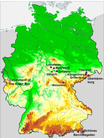
In the framework of the European research network Car-boEurope, test sites have been selected for detailed carbon budget analysis (Fig. 1). These sites are equipped with numerous high-quality environmental sensors, e.g. climate stations, eddy covariance towers, soil respiration chambers, soil moisture probes etc., for monitoring the carbon stocks and CO2fluxes in all relevant compartments and assembling essential state variables and parameters for modelling pur-poses. From Fig. 1 it becomes apparent that the sites are concentrated in the centre and in the far south of Germany. Also natural, mostly forested, sites are dominant within cur-rent observatory initiatives and an extension to anthropogeni-cally impacted, agricultural sites is required – a mission that could be associated ideally with the proposed TO.
3 Implementation of terrestrial observatories
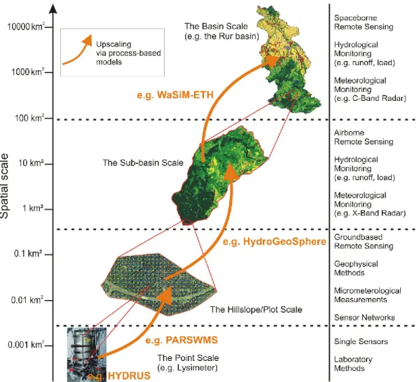
A terrestrial system in this context is defined as a system consisting of the subsurface environment, the land surface including the biosphere (organised in ecosystems), the lower atmosphere and the anthroposphere. These systems are or-ganised along a hierarchy of evolving scales and structures ranging from the local scale to the regional scale (Fig. 2). Hydrological units will be used as the basic scaling units, be-cause catchments are bordered by water divides representing laterally well-defined system boundaries.
Fig. 1. CarboEurope test sites in Germany and the catchment of the
River Rur.
In the framework of a TO, real-time measurement plat-forms have to be established that will allow terrestrial sys-tems directly influenced by human activities to be observed and enables the development of warning systems. Further-more, scientific experiments have to be carried out across a nested hierarchy of scales ranging from the local scale (small test sites) to large catchments.
In particular the establishment of terrestrial observatories will contribute to:
– studying the impact of land use changes, climate
change, socio-economic developments and human in-terventions on the evolution of terrestrial systems and their functioning and to analyse the interactions and feedback between the soil-vegetation and atmosphere compartments in these systems across a variety of scales;
– developing methods for upscaling parameters, fluxes
and state variables (PFS) that describe processes con-trolling matter fluxes in soil-plant-atmosphere systems representative of the functioning of the systems at the selected scales based on theoretical and modelling con-cepts (Fig. 2). This requires the measurement and obser-vation of multi-spatial and multi-temporal distributions
112 H. Bogena et al.: Observatories in terrestrial environmental research
Fig. 2. Hierarchy of evolving scales ranging from the local (point) scale to the regional (basin) scale, associated measurement techniques
and model-based upscaling.
of PFS in these systems. Especially the spatial varia-tion of PFS at different scales has not been taken into account in most of the operational networks up to now;
– providing high-quality data to validate existing and
newly developed model concepts (e.g. inverse mod-elling, stochastic data fusion approaches) and upscal-ing theories to estimate effective parameters, fluxes and state variables at various scales;
– bridging the gap between scales, measurements and
modelling currently present in hydrological and terres-trial sciences and developing and improving decision support systems for environmental management from the perspective of sustainable development;
– improving continuously integrated models that predict
the evolution of “man-made” terrestrial systems;
– promoting and supporting the development and use
of early warning systems (flooding, freshwater quality etc.);
– bringing together different disciplines to create
syner-getic effects, which will enable the analysis of interac-tions between natural patterns and processes of land-scapes with anthropogenic patterns and processes on different scales.
4 Criteria for terrestrial observatories
In order to capture terrestrial-atmospheric feedback, socio-economical disparities and demographical gradients the spa-tial scale of a terrestrial observatory should be in the range between 2000 km2 and 10 000 km2. Since hydrologic pro-cesses exert a fundamental control on aquatic and terres-trial metabolism and nutrient cycling, catchments repre-sent an ideal fundamental unit of TO. A distinct variety in climate, land use, demography etc. should be present over the whole catchment area to enable the consideration of mul-tiple site conditions. By combining different observatories within a network, even larger scale atmospheric feedbacks
and impacts and thus a more pronounced general link to the atmospheric research community could be established.
Near-natural zones (preferably national parks) should be part of the TO as reference sites. Comparative monitoring strategies that take into account the surrounding landscapes will enable the analysis of long-term environmental changes due to human impact. Ideally, the TO region should be the subject of prospective changes (e.g. open mining, renatura-tion arrangements, deforestarenatura-tion, economic and demograph-ical developments etc.) in order to analyse the effects of re-gional changes and disturbances.
Installations for the measurement of environmental and socio-economic quantities, influencing variables and indica-tors should be available for subsequent integration into the TO network. Within the terrestrial observatory, small-scale research facilities and test areas have to be in place in order to perform detailed process studies. By developing a con-cept of hierarchical scales this detailed information will be transferred to the regional scale (Fig. 2).
The TO has to be equipped with research instruments de-signed for long-term measurements. Important parameters, fluxes and state variables (PFS) for the compartments of the atmosphere, hydrosphere, soil, hydrogeology, and biosphere, as well as for socio-economic and demographic problems have to be monitored simultaneously. Different strategies should be considered depending on the time scale of ex-pected changes. Rapid, short-term variations will need to be monitored by fixed installed instruments that have to be net-worked via state-of-the-art communications in order to en-able near-real-time measurements and to simplify data man-agement, e.g. smart sensor networks. Smart sensor networks consist of a multitude of small sensors nodes embedded in the environment and are able to observe phenomena, e.g. temperature or soil moisture fields, with high temporal and spatial resolution. Slower variations of system states might best be observed by a system of mobile and flexible sensor networks that will operate periodically on a regular or event-driven basis thus allowing a more efficient and wider-area analysis. The monitoring and scientific programme has to be accompanied by high-performance systems for data storage and processing.
5 Prototype of a terrestrial observatory
Up to now it has never been attempted to set up multidis-ciplinary observatories of this spatial scale and complexity. This chapter aims to illustrate the concept of TO by choosing the catchment area of the River Rur as a concrete example to serve as a hydrology-related prototype for terrestrial ob-servatories. It covers a total area of 2354 km2and is situated in Western Germany (see Fig. 1). The catchment area ex-hibits a distinct land use gradient: The lowland region in the northern part is characterised by urbanisation and intensive agriculture whereas the low mountain range in the southern
part is sparsely populated and includes several drinking wa-ter reservoirs. Furthermore, the Eifel National Park is sit-uated in the southern part of the Rur catchment serving as a reference site. In the following, a monitoring concept for the Rur catchment is described that is capable of measuring the spatial-temporal variability of the main hydrological pro-cesses and interactions as well as the varying residence times of the terrestrial water stores.
Precipitation radars are considered suitable for estimating rates and distributions of precipitation fields on a range of scales by relating the reflection intensity Z to the precipita-tion intensity R. A network of point measurements of rain rates can be used in order to inversely establish the Z-R re-lation. The net ecosystem flux of H2O, momentum, sensi-ble and latent heat can be measured using eddy covariance systems, which will be installed across important gradients within the TO. These measurements will be co-located with radiation component budget measurements and standard me-teorological variables within stream-gauged sub-catchment areas.
Intensive soil moisture monitoring sites have to be collo-cated to climate towers for coordinated observation. Mea-surements will be made at several depths with TDR, FD, and pF sensors into the soil profile, where feasible as far as the water table. In addition to the multi-depth soil moisture mon-itoring sites, wireless sensor networks have to be established at the sub-catchment scale. The wireless sensor network technology has the potential to reveal dynamic changes in soil moisture with a high spatial-temporal resolution. Ground penetrating radar techniques should be applied for soil water content determination at the intermediate scale. The inte-grated measuring of water and heat fluxes and soil moisture allows the local closure of the water and energy budget at the plot scale. Such intensive test sites have to be placed along a transect across the TO in representative land cover, soil, and geologic settings to evaluate climate variability on recharge. In order to obtain spatially distributed information about river discharge rates, the TO needs to be partitioned into a nested set of sub-catchments that will span distinct assem-blages of hydrologic features and several orders of magni-tude in drainage area. These sub-catchments have to be in-strumented with flow velocity and water level measurement devices for a non-invasive, continuous and very precise mon-itoring of discharge rates and water quality in real time. More detailed measurements and characterisation of smaller, focal catchments have to be embedded within progressively larger catchments, allowing the critical evaluation and development of hydrologic scaling strategies. Additionally, for the anal-ysis of the groundwater flow system and groundwater ex-change rates on a regional scale the monitoring of natural tracers (e.g. radon) of ground and surface waters within the TO should be carried out.
The evaluation of the effects of global and regional changes on the hydrological regime in the Rur catchment have to be accompanied by an analysis of the consumptive
114 H. Bogena et al.: Observatories in terrestrial environmental research
water use and water management activities as well as point source emissions (e.g. water reservoirs, draining of mines, discharges from industrial and municipal sewage treatment etc.).
In order to monitor the processes controlling matter fluxes in soil-plant-atmosphere systems the described hydrological monitoring concept has to be extended by adding other rel-evant compartments (e.g. soil, vegetation, and atmosphere) and by a socioeconomic analysis. This may include the iden-tification of socioeconomic forces that drive the intensifi-cation and/or de-intensifiintensifi-cation processes (e.g. demographic and technological change) and the feedback to the ecologi-cal system (e.g. on the state of soil, water and air quality) as well as the analysis of ecological impacts of land use changes across and within sectors (e.g. from agricultural to industrial types or from chemical to energy production).
6 Conclusions
Environmental and terrestrial research still has to deal with a gap between the scale at which we understand the function-ing of terrestrial systems and the scale at which management strategies for our environment have to be developed and ap-plied. There are several reasons for this:
– Compared to the atmospheric or the marine
compart-ments, the terrestrial compartment is a highly complex and diverse system, exhibiting strong heterogeneities across all scales.
– Terrestrial systems have an inherent spatial
variabil-ity characterised by continuously evolving scales and a multitude of processes interacting in a complex manner within and across compartments of terrestrial systems.
– The prediction and description of these processes at
larger scales is hampered by the lack of validated mod-els caused by the non-availability of appropriate mea-surement technologies and scientifically based concepts and approaches to parameterise these models.
– In this respect, terrestrial research lags some way
be-hind atmospheric and marine sciences both in terms of operational measurement platforms and modelling.
– Terrestrial observatories present ideal locations for the
development and the validation of integrated modelling approaches at the regional scale.
Despite its complexity, the terrestrial component in most process-based climate and biosphere models is typically rep-resented in a very conceptual way. Against the background of global change, remedying this deficiency is therefore one of the most important challenges in environmental and ter-restrial research. Therefore, the implementation of terter-restrial observatories could be an important step towards a new qual-ity of environmental and terrestrial research.
Edited by: R. Barthel, J. G¨otzinger, G. Hartmann, J. Jagelke, V. Rojanschi, and J. Wolf
Reviewed by: anonymous referees
References
Bellamy, P., Loveland, P., Bradley, R., Lark, R., and Kirk, G.: Car-bon losses from all soils across England and Wales 1978–2003, Nature, 437, 245–248, 2005.
Blair, J.: Meeting Minutes of the Spring 2004 LTER Coordinating Committee (CC) Meeting, 28–29 April 2004, Santa Barbara, CA, 2004.
CarboEurope: http://www.carboeurope.org/, date of access: 7 June 2006.
Collaborative Large-Scale Engineering Analysis Network for Envi-ronmental Research (CLEANER): http://cleaner.ncsa.uiuc.edu/ people/, date of access: 7 June 2006.
Consortium of Universities for the Advancement of Hydrologic Sci-ence (CUAHSI): http://www.cuahsi.org/index.html, date of ac-cess: 7 June 2006.
Davidson, E. A., Trumbore, S. E., and Amundson, R.: Soil warming and organic carbon content, Nature, 408, 789–790, 2000. European Environmental Agency (EEA): Impacts of Europe’s
changing climate – an indicator-based assessment, EEA Report, No. 2/2004, 2004.
FLUXNET: http://www.fluxnet.ornl.gov/fluxnet/index.cfm, date of access: 7 June 2006.
Giardina, C. P. and Ryan, M. G.: Evidence that decomposition rates of organic carbon in mineral soil do not vary with temperature, Nature, 404, 858–861, 2000.
Global Land Project (GLP): Science Plan and Implementation Strat-egy, IGBP Report No. 53/IHDP Report No. 19, 2005.
International Long Term Ecological Research – Deutschland (LTER-D): http://www.lter-d.de/, date of access: 7 June 2006. Knorr, W., Prentice, I. C., House, J. I., and Holland, E. A.:
Long-term sensitivity of soil carbon turnover to warming, Nature, 433, 298–301, 2005.
McCarthy, J. J., Canziani, O. F., Leary, N. A., Dokken, D. J., and White, K. S.: Climate Change 2001: Impacts, Adaptation, and Vulnerability, IPCC Third Assessment Report, Cambridge Uni-versity Press, 2001.
National Ecological Observatory Network initiative (NEON): http: //www.neoninc.org/, date of access: 7 June 2006.
International Long Term Ecological Research (ILTER): http://www. ilternet.edu/, date of access: 7 June 2006.
Osmond, B., Ananyev, G., Berry, J., Langdon, C., Kolber, Z., Lin, G., Monson, R., Nichol, C., Rascher, U., Schurr, U., Smith, S., and Yakir, D.: Changing the way we think about global change research: scaling up in experimental ecosystem science, Global Change Biology, 10, 393–407, 2004.
Parr, T. W., Sier, A. R. J., Battarbee, R. W., Mackay, A., and Burgess, J.: Detecting environmental change: science and society-perspectives on long-term research and monitoring in the 21st century, The Science of the Total Environment, 310, 1–8, 2003.
Powlson, D.: Will soil amplify climate change? Nature, 433, 204– 205, 2005.