HAL Id: hal-00296826
https://hal.archives-ouvertes.fr/hal-00296826
Submitted on 16 Dec 2005
HAL is a multi-disciplinary open access
archive for the deposit and dissemination of
sci-entific research documents, whether they are
pub-lished or not. The documents may come from
teaching and research institutions in France or
abroad, or from public or private research centers.
L’archive ouverte pluridisciplinaire HAL, est
destinée au dépôt et à la diffusion de documents
scientifiques de niveau recherche, publiés ou non,
émanant des établissements d’enseignement et de
recherche français ou étrangers, des laboratoires
publics ou privés.
Use of microwave remote sensing data to monitor spatio
temporal characteristics of surface soil moisture at local
and regional scales
A. Löw, R. Ludwig, W. Mauser
To cite this version:
A. Löw, R. Ludwig, W. Mauser. Use of microwave remote sensing data to monitor spatio temporal
characteristics of surface soil moisture at local and regional scales. Advances in Geosciences, European
Geosciences Union, 2005, 5, pp.49-56. �hal-00296826�
Advances in Geosciences, 5, 49–56, 2005 SRef-ID: 1680-7359/adgeo/2005-5-49 European Geosciences Union
© 2005 Author(s). This work is licensed under a Creative Commons License.
Advances in
Geosciences
Use of microwave remote sensing data to monitor spatio temporal
characteristics of surface soil moisture at local and regional scales
A. L¨ow, R. Ludwig, and W. Mauser
Department of Earth and Environmental Sciences, University of Munich, Luisenstr. 37, 80333 Munich, Germany Received: 7 January 2005 – Revised: 1 August 2005 – Accepted: 1 September 2005 – Published: 16 December 2005
Abstract. Hydrologic processes, such as runoff production
or evapotranspiration, largely depend on the variation of soil moisture and its spatial pattern. The interaction of electro-magnetic waves with the land surface can be dependant on the water content of the uppermost soil layer. Especially in the microwave domain of the electromagnetic spectrum, this is the case. New sensors as e.g. ENVISAT ASAR, allow for frequent, synoptically and homogeneous image acquisitions over larger areas. Parameter inversion models are therefore developed to derive bio- and geophysical parameters from the image products. The paper presents a soil moisture inver-sion model for ENVISAT ASAR data for local and regional scale applications. The model is validated against in situ soil moisture measurements. The various sources of uncertain-ties, being related to the inversion process are assessed and quantified.
1 Introduction
Water affects all economic, cultural, social and ecological aspects of daily life and is basic to functioning matter fluxes and hence for a clean and stable environment. Its availability, quality and allocation is largely affected by Global Change, which summarizes the complex interactions of changes not only in the global climate and water system but also changes in population, development and economy. Thus solitary sci-ences, with their inevitably unilateral view of the world, are neither capable to understand the complex interactions between nature, water and man nor to develop methods for a sustainable water resource management under glob-ally changing boundary conditions. The same applies to the present state of observation systems, which often serve the very specific needs of small research communities and are of-ten not integrated into larger and more complex approaches. Correspondence to: A. L¨ow
(a.loew@lmu.de)
A major objective of recent Global Change research pro-grams as e.g. the GLOWA-Danube project (Mauser and Lud-wig, 2002; Ludwig et al., 2003) is therefore the development of complex integrative models which can be used as tools for scenario based decision making. A monitoring of large areas, based on remote sensing techniques, is mandatory to provide the needed spatially distributed input datasets to those mod-els to validate and improve the model results on a regional scale. New sensors, as ENVISAT ASAR (Advanced Syn-thetic Aperture Radar), enable frequent observations of large areas at regional scale with an appropriate spatial resolution for mesoscale applications. The ASAR Wide Swath Mode (WSM) has a high potential in this context (ESA, 2002). The swath width of 400 km enables the acquisition of homoge-neous, temporal consistent datasets of entire mesoscale river catchments at a spatial resolution of 150 m. Additionally, image acquisitions with higher spatial resolution is possi-ble with the image and alternating polarization modes (ESA, 2002), which allow for a better comparison of the image data with ground measurements.
A key parameter for the energy and mass fluxes at the land surface is the actual water content of the soil layer. An accurate and comprehensive, spatially distributed estima-tion of the soil moisture content is therefore needed. The potential to quantify soil moisture patterns of the top soil layer (3–5 cm) with microwave imagery has been success-fully demonstrated in numerous studies (e.g. Engman, 1998; Quesney et al., 2000; Dubois et al., 1995; Wigneron et al., 2003; Le H´egarat-Mascle et al., 2002). Contrasting earlier and rather experimental research efforts, data acquired from the ENVISAT ASAR sensor firstly enables to continuously monitor large areas with high frequency (3–4 images per week in mid-latitudes) and high spatial resolution from the local (30 m resolution/100 km coverage) to the regional scale (150 m/400 km).
The paper presents an inversion methodology for EN-VISAT ASAR data to retrieve the soil moisture content of the uppermost soil layer. The semi empirical approach is validated against in situ soil moisture measurements. Despite
50 A. L¨ow et al.: Use of microwave remote sensing data to monitor spatio temporal characteristics the fact, that remote sensing data provide independent
infor-mation about the interaction of electromagnetic waves with the land surface by means of reflected or scattered energy, each attempt to invert bio- and geophysical parameters from the data will be based on inversion models with a limited de-gree of accuracy. An uncertainty analysis of the presented soil moisture inversion approach is therefore conducted to assess the influences of data and model parameter induced uncertainties to the retrieved soil moisture values.
2 Testsite and datasets
The present work was conducted within the InFerno+ project, which has been established for the assimilation of remote sensing data in operational flood forecasting systems (Schulz et al., 2002). The testsites of this project, namely the Mosel, Neckar and Ammer river catchments, are located in southern Germany. All testsites are equipped with perma-nently registering soil moisture stations and a dense network of meteorological weather stations. A geographical informa-tion system with a spatial resoluinforma-tion of 30 m is available for the entire area, including information about the actual land cover, soil texture and topography.
More than 50 ENVISAT ASAR images, acquired since the year 2002 over the testareas form the database for the anal-ysis on local and regional scale. Extensive field campaigns were carried out during sensor passes to sample additional ground truth information about the actual soil moisture con-ditions on various agricultural test fields.
2.1 Data characteristics
The ENVISAT ASAR sensor allows for image acquisitions in different imaging geometries, which enables to monitor an area of interest from different sensor pathes and thus in-creases the temporal repetition frequency significantly. Due to the different imaging geometries, the incidence angle (an-gle between ellipsoid normal and incident beam) changes, which affects the amount of backscattered energy. The large swath width of a WSM image corresponds to incidence an-gles ranging from 15◦ to 45◦. Thus, parameter inversion models have to account for this incidence angle change and its effect on the backscattering coefficient.
For mesoscale image products, as the WSM mode, image pixels can not be treated as homogeneous. The backscatter-ing coefficient of a resolution cell is a function of different land cover types within the image pixel. To allow for a quan-titative estimate of land surface parameters from those image products, it is mandatory to care for the subscale heterogene-ity of the image pixels (L¨ow et al., 2003; Schneider and Op-pelt, 1998). Using a high resolution (30 m) land use classifi-cation developed by Stolz et al. (2004), the fractions of each land use can be determined for each mesoscale image pixel. This ancillary information is used for the preprocessing of the image data and the derivation of quantitative parameters from mesoscale ENVISAT ASAR imagery.
3 Determination of surface soil moisture from
EN-VISAT ASAR data
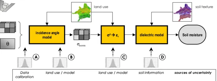
To derive quantitative information about the surface soil moisture from ENVISAT ASAR data, an appropriate prepro-cessing of the image data is crucial to obtain reliable esti-mates of the backscattering coefficient. These can be used to invert land surface parameters from the image. The prin-ciple methodology to derive soil moisture of the upper soil layer from ENVISAT ASAR data is outlined in the follow-ing. It has been described in more detail by L¨ow et al. (2004). The methodology is applicable at local as well as at regional scales. Figure 1 shows the principle data flow for soil mois-ture inversion from SAR data and the sources of model un-certainties to be discussed later on in Sect. 4.
3.1 Geocoding
The image geometrical and radiometrical properties are dis-torted due to changes in local topography. The image pix-els are displaced due to topography and the changing local scattering area results in significant backscatter changes up to several decibels. This has to be compensated to obtain reliable estimates of the backscattering coefficient as a func-tion of surface characteristics. The SAR images are there-fore precisely geocoded using the Range-Doppler approach after calibrating the ENVISAT ASAR data to image bright-ness values (β0). It has been shown, that SAR images can be normalized by taking into account ancillary information about local topography (L¨ow and Mauser, 2003; Small et al., 2004) and that significant improvements of the radiometric accuracy of the data can be achieved in this way (Riegler and Mauser, 1998; L¨ow, 2004). The local scattering area is cal-culated by taking into account the local slope and aspect with respect to the incident wave. The normalized backscattering coefficient σ0, being comparable to the backscatter from flat earth is obtained by normalizing the image brightness value by the local scattering area.
3.2 Incidence angle normalization
The terrain corrected backscattering coefficients are mainly a function of surface characteristics and the incidence angle. Figure 2 shows an example of the incidence angle depen-dency of the backscattering coefficient on crop and grass-land, as derived from multitemporal analysis of image statis-tics. Clearly can be seen, that the backscattering coefficient decreases with increasing incidence angle. Due to the large possible incidence angle range of ENVISAT ASAR data, a normalization of the incidence angle effects on the signal is mandatory for quantitative image analysis. This ensures the comparability between multiple image datasets. This nor-malization is achieved by using land use dependant linear in-cidence angle models as those shown in Fig. 2 to normalize a measured backscattering coefficient to a reference imaging geometry (L¨ow et al., 2004). It is shown that the normal-ization model only accounts for part of the variability of the
A. L¨ow et al.: Use of microwave remote sensing data to monitor spatio temporal characteristics 51
(2004). The methodology is applicable at local as well as at regional scales. Fig. 1 shows the principle data flow for soil
moisture inversion from SAR data and the sources of model uncertainties to be discussed later on in chapter 4.
θθ
incidence angle
model σσσσ0ÆÆÆÆεεεεr dielectric model
sources of uncertainty
Data
calibrationData
calibration land use / modelland use / model land use / modelland use / model soil informationsoil information
land use soil texture
σnorm
Soil moisture Soil moisture
A
A BB CC DD
Fig.1:
Principle of soil moisture inversion from ENVISAT ASAR data and sources of uncertainties
3.1 Geocoding
The image geometrical and radiometrical properties are distorted due to changes in local topography. The image
pixels are displaced due to topography and the changing local scattering area results in significant backscatter changes
up to several decibels. This has to be compensated to obtain reliable estimates of the backscattering coefficient as a
function of surface characteristics. The SAR images were precisely geocoded using the Range-Doppler approach after
calibrating the ENVISAT ASAR data to image brightness values (
β
0). It has been shown, that SAR images can be
normalized by taking into account ancillary information about local topography (Löw & Mauser, 2003; Small et al.,
2004) and that significant improvements of the radiometric accuracy of the data can be achieved in this way (Riegler &
Mauser, 1998; Löw, 2004). The local scattering area is calculated by taking into account the local slope and aspect with
respect to the incident wave. The normalized backscattering coefficient
σ
0, being comparable to the backscatter from
flat earth is obtained by normalize the image brightness value by the local scattering area.
3.2 Incidence
angle
normalization
The terrain corrected backscattering coefficients are mainly a function of surface characteristics and the incidence
angle.
Fig. 2 shows an example of the incidence angle dependency of the backscattering coefficient on crop and grassland,
as derived from multitemporal analysis of image statistics. Clearly can be seen, that the backscattering coefficient
decreases with increasing incidence angle. Due to the large possible incidence angle range of ENVISAT ASAR data, a
normalization of the incidence angle effects on the signal is mandatory for quantitative image analysis. This ensures the
comparability between multiple image datasets. This normalization is achieved by using land use dependant linear
Fig. 1. Principle of soil moisture inversion from ENVISAT ASAR data and sources of uncertainties.
data. The backscattering coefficient is as well influenced by soil moisture, vegetation effects and surface roughness which should be theoretically be taken into account in the normal-ization procedure. This can not be achieved for larger ar-eas due to missing data. The estimated angular backscatter variability is therefore an approximation to the land surface microwave interactions as function of incidence angle. The uncertainty which is induced by the normalization model is assessed in Sect. 4.
3.3 Soil moisture inversion
The developed soil moisture inversion approach is based on a semiempirical model which was formerly developed for ERS data (Rombach and Mauser, 1997). It has been shown in different test sites in Europe, that the model can be used to invert soil moisture with an accuracy of 4 vol.% (Bach and Mauser, 2003) and that it can also be applied for mesoscale SAR data (L¨ow et al., 2003). The model is mainly validated for vegetated areas and different crop types. The backscat-tering coefficient is known to be very sensitive to surface roughness as well as to soil moisture (Oh et al., 1992; Zribi and Dechambre, 2002). The bare soil contribution is atten-uated by the vegetation canopy and the influence of surface roughness therefore decreases. If additional surface rough-ness information is available it can be used to improve soil moisture inversion results (Zribi and Dechambre, 2002; L¨ow, 2004). Vegetation effects on the signal are treated to remain constant after a certain phenological stage which has been shown to be valid as a first approximation (Rombach and Mauser, 1997). Nevertheless soil moisture inversion results can be significantly improved if vegetation growth dynamics is taken into account in the inversion process by means of vegetation biomass and water content (L¨ow, 2004; Quesney et al., 2000; Mattia et al., 2003)
This model is adapted for ENVISAT ASAR data by com-pensating for the changing incidence angles and subpixel het-erogeneities.
As shown in Fig. 4 the relationship between the dielectric constant and mv is dependant on the soil texture. Thus
additional information about soil texture is required.
Incidence angle dependency (cropland & grassland)
incidence angle [°] 15 20 25 30 35 40 45 ba ckscat te rin g co ef fici e n t x 10.000 0 1000 2000 3000 4000 5000 cropland grassland y=-54.8x+3018.6, R²=0.80 y=-85.7x+4565.9, R²=0.67
Fig. 2: Incidence angle dependency of SAR backscatter for grassland and crop land
dielectric constant of soil ε'
0 10 20 30 40 50 60 Ba ck sca tt er [ d B ] -18 -16 -14 -12 -10 -8 -6 -4 -2 0 maize barley rye harvested meadow root crops
Fig. 3: Empirical relationship between dielectric constant and backscatter for various land use types
Fig. 2. Incidence angle dependency of SAR backscatter for grass-land and crop grass-land.
The approach consists of basically two steps. In a first step, the radar backscatter σ0is related to the dielectric con-stant of the soil by a 2nd order polynomial. The empirical relationships between the backscattering coefficient and the dielectric constant εr are dependant on the land use (Fig. 3).
Detailed information about the actual land use is therefore required to obtain best inversion results. If no or only impre-cise land use information is available, the uncertainties of the inversion results will increase. In forested and urban areas, soil moisture information can not be derived from the image data.
In a second step, the dielectric constant is converted to a volumetric soil moisture content mvusing a dielectric model
52 A. L¨ow et al.: Use of microwave remote sensing data to monitor spatio temporal characteristics
As shown in Fig. 4 the relationship between the dielectric constant and mv is dependant on the soil texture. Thus additional information about soil texture is required.
Incidence angle dependency (cropland & grassland)
incidence angle [°] 15 20 25 30 35 40 45 ba ckscat te rin g co ef fici e n t x 10.000 0 1000 2000 3000 4000 5000 cropland grassland y=-54.8x+3018.6, R²=0.80 y=-85.7x+4565.9, R²=0.67
Fig. 2: Incidence angle dependency of SAR backscatter for grassland and crop land
dielectric constant of soil ε'
0 10 20 30 40 50 60 Ba ck sca tt er [ d B ] -18 -16 -14 -12 -10 -8 -6 -4 -2 0 maize barley rye harvested meadow root crops
Fig. 3: Empirical relationship between dielectric constant and backscatter for various land use types Fig. 3.backscatter for various land use types.Empirical relationship between dielectric constant and
soil moisture (5.3 GHz) volumetric moisture 0.0 0.1 0.2 0.3 0.4 0.5 0.6 d ie le c tr ic c o n sta n t 0 10 20 30 40 sandy loam loam silt loam silt loam silty clay
Fig. 4: Dielectric constant of soils as function of water content and soil texture
soil moisture inversion from SAR data
measured soil moisture [Vol.%]
0 5 10 15 20 25 30 35 40 45 50 re tr ie ve d s o il m o istu re from S A R d a ta [ V o l.% ] 0 5 10 15 20 25 30 35 40 45 50 image mode (30m)
y=0.54x+10.78, R²=0.54, rmse=4.0 vol.% wide swath mode (150m) y=0.56x+9.16, R²=0.40, rmse=5.7 vol.%
Fig. 5: Comparison between measured and retrieved soil moisture values at 30m and 150m resolution
3.4 Model validation
To quantify the accuracy of the proposed soil moisture inversion scheme, comparisons with ground measurements are made at local and regional scale. The inverted soil moisture values from the image data (30m, 150m) are validated against in situ measured TDR probes. Fig. 5 shows measured and retrieved soil moisture values, as derived from different ASAR images with various imaging geometries. It can be seen, that the retrieved soil moisture values are almost within a range of ±5 Vol.% which is a promising result.
It has to be emphasized that these comparisons are made on the resolution cell size of the image data (30m, 150m). The in situ soil moisture measurements are only a representative for a small area and not for the entire resolution cell size of the SAR image. Due to the spatial variability of the soil moisture it is difficult to compare the point
Fig. 4. Dielectric constant of soils as function of water content and soil texture.
As shown in Fig. 4 the relationship between the dielectric constant and mvis dependant on the soil texture. Thus
addi-tional information about soil texture is required. 3.4 Model validation
To quantify the accuracy of the proposed soil moisture in-version scheme, comparisons with ground measurements are made at local and regional scale. The inverted soil mois-ture values from the image data (30 m, 150 m) are validated against in situ measured TDR probes. Figure 5 shows mea-sured and retrieved soil moisture values, as derived from dif-ferent ASAR images with various imaging geometries. It can be seen, that the retrieved soil moisture values are almost within a range of ±5 vol.% which is a promising result.
soil moisture (5.3 GHz) volumetric moisture 0.0 0.1 0.2 0.3 0.4 0.5 0.6 d ie le c tr ic c o n sta n t 0 10 20 30 40 sandy loam loam silt loam silt loam silty clay
Fig. 4: Dielectric constant of soils as function of water content and soil texture
soil moisture inversion from SAR data
measured soil moisture [Vol.%]
0 5 10 15 20 25 30 35 40 45 50 re tr ie ve d s o il m o istu re from S A R d a ta [ V o l.% ] 0 5 10 15 20 25 30 35 40 45 50 image mode (30m)
y=0.54x+10.78, R²=0.54, rmse=4.0 vol.% wide swath mode (150m) y=0.56x+9.16, R²=0.40, rmse=5.7 vol.%
Fig. 5: Comparison between measured and retrieved soil moisture values at 30m and 150m resolution
3.4 Model validation
To quantify the accuracy of the proposed soil moisture inversion scheme, comparisons with ground measurements are made at local and regional scale. The inverted soil moisture values from the image data (30m, 150m) are validated against in situ measured TDR probes. Fig. 5 shows measured and retrieved soil moisture values, as derived from different ASAR images with various imaging geometries. It can be seen, that the retrieved soil moisture values are almost within a range of ±5 Vol.% which is a promising result.
It has to be emphasized that these comparisons are made on the resolution cell size of the image data (30m, 150m). The in situ soil moisture measurements are only a representative for a small area and not for the entire resolution cell size of the SAR image. Due to the spatial variability of the soil moisture it is difficult to compare the point
Fig. 5. Comparison between measured and retrieved soil moisture values at 30m and 150m resolution.
It has to be emphasized that these comparisons are made on the resolution cell size of the image data (30 m, 150 m). The in situ soil moisture measurements are only a representa-tive for a small area and not for the entire resolution cell size of the SAR image. Due to the spatial variability of the soil moisture it is difficult to compare the point measurements with the image data. A systematic analysis of the variability of the soil moisture within agricultural fields revealed stan-dard deviations of the soil moisture values between 2 vol.% and 8 vol.%. This scale gap introduces additional uncertainty to the validation of the model results. Thus the variability of the retrieved soil moisture, compared to the in situ measure-ments is partly a result of the scale gap between the point measurements and the image resolution cell size, as well as uncertainties resulting from land use information and impre-cise soil texture maps.
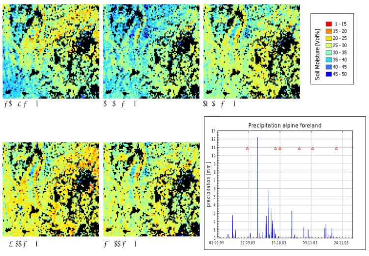
Figure 6 shows examples of derived surface soil moisture maps and their temporal development. It can be seen, that the soil moisture patterns are consistent with the observed precipitation evolution within the same area.
4 Uncertainty analysis
Each modelling process is associated with uncertainties which are the result of simplified assumptions being made in the model and imprecise input datasets provided to the model. The total model uncertainty is the result of the inter-ference of different contributing sources. For the presented soil moisture inversion model these sources of uncertainty are (Fig. 1).
1. image calibration errors: the radiometric calibration error of ASAR image products is within 0.5–1.0 dB (Rosich et al., 2003)
2. incidence angle correction: the empirical correction of the incidence angle effect on the signal, as shown in
A. L¨ow et al.: Use of microwave remote sensing data to monitor spatio temporal characteristics 53 13.10.2003 21.09.2003 04.11.2003 10.10.2003 20.11.2003
Precipitation alpine foreland
01.09.03 22.09.03 13.10.03 03.11.03 24.11.03 p re c ip ita tio n [ m m ] 0 1 2 3 4 5 6 7 8 9 10 11 12 13 S o il Moist u re [V ol%]
Fig. 6. Multitemporal soil moisture patterns around Munich (Germany) as a function of precipitation distribution.
Fig. 3 only accounts for a part of the variance while a certain amount remains unexplained by the linear re-gression model.
3. land use specific derivation of the dielectric constant (εr): To convert the backscattering coefficient to
dielec-tric constant values, the actual land use has to be known. Uncertainties result from non existing or imprecise land use information as well as from the inversion model it-self which is calibrated empirically
4. unknown soil texture information: the dielectric con-stant is converted to volumetric soil moisture with a high degree of accuracy using a dielectric mixture model. Due to a lack of spatially distributed precise soil texture information for the upper soil layer, the volu-metric soil moisture content (mv)can only be converted
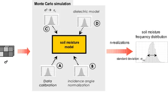
from dielectric measurements with uncertainties. In the following, the impact of the different sources of un-certainties on the soil moisture retrieval is assessed using a Monte Carlo based approach (Fig. 7). Soil moisture is in-verted for backscatter values in the range of −18 to −3 dB using the presented approach with a resolution of 0.05 dB.
For each backscatter value a number of 10 000 model realiza-tions is inverted to soil moisture values. The different model realizations are achieved by adding random gaussian noise according to Table 1 for the different terms of uncertainty mentioned above. These values are estimated from known SAR image calibration uncertainties (Rosich et al., 2003) as well as from assumptions being made for the error that could be induced by the different model terms. The incidence an-gle normalization uncertainty is derived from the residues of the linear regression line in Fig. 2 while the uncertainties of the estimates of the dielectric constant and volumetric soil moisture can be derived from the variability of the parame-ters which is shown in Fig. 3 and Fig. 4.
The frequency distribution and the first and second order moment of the obtained soil moisture values is calculated.
To assess the impact of the various uncertainty sources on the total model accuracy, simulations are also conducted where random noise is added only for a single variable. This gives a measure for the sensitivity of the model on the differ-ent uncertainty terms.
Figure 8 shows an example of uncertainty analysis results for arable land and an incidence angle of 30◦. The results obtained when only a single noise term is added, as well
54 A. L¨ow et al.: Use of microwave remote sensing data to monitor spatio temporal characteristics σ0 σ0 n-realizations soil moisture frequency distribution standard deviation:σmv soil moisture model Data calibrationData calibration dielectric model σ0Æ ε r incidence angle normalization A A BB C C D D Monte Carlo simulation
Fig. 7:
Assessment of uncertainties in soil moisture inversion by means of Monte Carlo simulations
Table I: Gaussian noise standard deviation (
σ
) for Monte Carlo based analysis of different terms of uncertainty
Uncertainty
source Unit
σσσσ
A Image
calibration
dB 0.5
B Incidence
angle
compensation
m²/m²
485
C Backscatter
to
dielectric constant
- 2.5
D Dielectric
model vol.%
3.0
The different contributions of the various uncertainty terms can be summarized as follows:
A) the image calibration has a small effect on the soil moisture retrievals. With increasing backscattering
coefficient, the influence of the calibration quality increases due to a reduced sensitivity of the backscattering
coefficient to soil moisture changes.
B) The influence of the incidence angle normalization procedure to the model accuracy is affected by the
magnitude of the backscattering coefficient. For low backscattering coefficients, corresponding to low soil
moisture content, uncertainties are higher than for those of higher backscatter values. This is obviously caused
by the better signal to noise ratio for the higher backscattering values due to the fact, that a constant gaussian
noise is used for the simulations for the entire backscatter range.
Fig. 7. Assessment of uncertainties in soil moisture inversion by means of Monte Carlo simulations.
Table 1. Gaussian noise standard deviation (s) for Monte Carlo based analysis of different terms of uncertainty.
Uncertainty source Unit σ
A Image calibration dB 0.5
B Incidence angle compensation m2/m2 485
C Backscatter to dielectric constant – 2.5
D Dielectric model vol.% 3.0
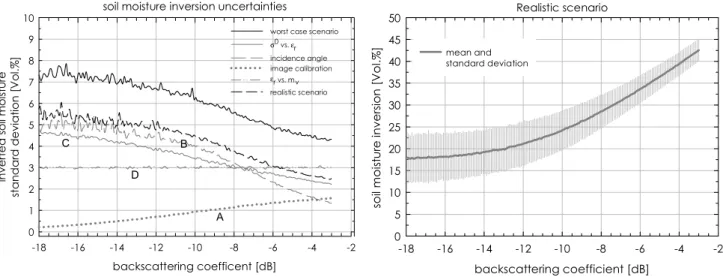
as the result of the interference of the different noise terms are shown. The interference result corresponds to a worst case scenario where no detailed information about the actual land use and soil texture is available. For this worst case, the standard deviation of the inverted soil moisture values is ap-proximately 7 vol.% for low backscattering coefficients and decreases to 4.5 vol.% for higher backscattering coefficients. The different contributions of the various uncertainty terms can be summarized as follows:
1. the image calibration has a small effect on the soil mois-ture retrievals. With increasing backscattering coeffi-cient, the influence of the calibration quality increases due to a reduced sensitivity of the backscattering coeffi-cient to soil moisture changes.
2. The influence of the incidence angle normalization pro-cedure to the model accuracy is affected by the magni-tude of the backscattering coefficient. For low backscat-tering coefficients, corresponding to low soil moisture content, uncertainties are higher than for those of higher backscatter values. This is obviously caused by the bet-ter signal to noise ratio for the higher backscatbet-tering val-ues due to the fact, that a constant gaussian noise is used for the simulations for the entire backscatter range.
3. If no detailed information about land cover is available, only a mean relationship between the dielectric constant and the backscattering coefficient can be assumed. This results in a standard deviations of 2.5 to 4.5 vol.% for the inverted soil moisture values.
4. The conversion of the dielectric constant to volumet-ric soil moisture content is dependant on the available soil texture information. The uncertainties in the soil moisture retrieval results, which are caused by a lack of soil texture information, contribute a systematic bias of 3 vol.% to the inversion results.
Typically, the different sources of uncertainties interfere and the resulting model uncertainty is higher than that of the singular error sources which is shown by the worst case sce-nario. Additional information can be provided to the inver-sion process by means of spatially distributed land cover and soil texture information which increases the accuracy of the soil moisture inversions. Figure 8 shows also the simula-tion results of such a more realistic scenario where the noise for the conversion of the backscattering coefficient to dielec-tric constant (C) as well as for the conversion from εr to mv
(D) was assigned a more realistic value of 1.0 due to prior land use and soil texture knowledge. It can be seen, that the uncertainties of the soil moisture retrievals decrease with higher backscattering coefficients. A significant reduction of the standard deviation over the entire backscatter range can be observed, compared to the worst case scenario. For low backscatter values, the inversion results have a standard deviation of approximately 5.5 vol.% which depletes below 3 vol.% for higher backscatter values.
Commonly, remote sensing derived surface parameters are validated against in situ measurements as it has also been done for the present model (Fig. 5). Typically the in situ mea-surements are treated to represent the expected true value,
A. L¨ow et al.: Use of microwave remote sensing data to monitor spatio temporal characteristics 55
soil moisture inversion uncertainties
backscattering coefficent [dB] -18 -16 -14 -12 -10 -8 -6 -4 -2 in ve rt e d soil moi st ur e st and a rd devi ati o n [V o l.% ] 0 1 2 3 4 5 6 7 8 9 10
worst case scenario
σ0 vs. εr incidence angle image calibration εr vs. mv realistic scenario Realistic scenario backscattering coefficient [dB] -18 -16 -14 -12 -10 -8 -6 -4 -2 so il mois tu re in ve rs io n [ V ol. % ] 0 5 10 15 20 25 30 35 40 45 50 mean and standard deviation A B C D
Fig. 8:
Soil moisture inversion uncertainties based on Monte Carlo simulations assuming singular and
combinations of different sources of uncertainty at an incidence angle of 30°: standard deviations of inverted soil
moisture values (left) and relationship between backscattering coefficient and soil moisture, including uncertainties
(right)
5 Conclusions
The proposed soil moisture inversion model has shown promising results at the local as well as at the regional scale.
It enables the homogeneous derivation of surface soil moisture for mesoscale watersheds. To obtain best inversion
results, appropriate land use and soil texture information is required. The uncertainty analysis revealed that inversion
uncertainties decrease with increasing soil moisture content. This is of particular interest for applications in flood
forecasting and surface runoff prediction. The uncertainties at higher soil moisture values are comparable to those
resulting from in situ measurements. Thus, ENVISAT ASAR data has the potential to provide spatially distributed soil
moisture information at a high level of accuracy if the necessary input datasets are available with sufficient precision. A
constraint remains in the fact that the soil moisture content of the root zone is typically required for hydrological
applications. Adaptive data assimilation techniques are therefore required to use remote sensing derived soil moisture to
update hydrological model state variables.
Acknowledgements. The work was supported by the German Space Agency (DLR) under contract #50EE0053 and the ENVISAT ASAR data was provided by the European Space Agency within their PI program which is gratefully acknowledged.
References
Bach, H., Mauser, W.: Methods and examples for remote sensing data assimilation in land surface process modelling, IEEE Trans. on Geoscience and Remote Sensing, vol.41, No.7, pp. 1629-1637, 2003.
Fig. 8. Soil moisture inversion uncertainties based on Monte Carlo simulations assuming singular and combinations of different sources of
uncertainty at an incidence angle of 30◦: standard deviations of inverted soil moisture values (left) and relationship between backscattering
coefficient and soil moisture, including uncertainties (right).
but they are as well associated with uncertainties. If ground based soil moisture measurements are made on a spatial res-olution being comparable to the SAR sensor resres-olution cell size (>30 m), the in situ measurements show soil moisture standard deviations between 1 vol.% up to 10 vol.% (L¨ow, 2004; Huisman, 2002). Based on an analysis of a large database of soil moisture measurements on multiple sites and agricultural crops, typical inner field soil moisture standard deviations were found to range from 2 vol.% to 5 vol.%. Thus, the variability of the in situ soil moisture measure-ments is within the same order than those resulting from un-certainties in the realistic soil moisture inversion scenario.
5 Conclusions
The proposed soil moisture inversion model has shown promising results at the local as well as at the regional scale. It enables the homogeneous derivation of surface soil mois-ture for mesoscale watersheds. To obtain best inversion re-sults, appropriate land use and soil texture information is required. The uncertainty analysis revealed that inversion uncertainties decrease with increasing soil moisture content. This is of particular interest for applications in flood fore-casting and surface runoff prediction. The uncertainties at higher soil moisture values are comparable to those result-ing from in situ measurements. Thus, ENVISAT ASAR data has the potential to provide spatially distributed soil mois-ture information at a high level of accuracy if the necessary input datasets are available with sufficient precision. A con-straint remains in the fact that the soil moisture content of the root zone is typically required for hydrological applications. Adaptive data assimilation techniques are therefore required to use remote sensing derived soil moisture to update hydro-logical model state variables.
Acknowledgements. The work was supported by the German Aerospace Center (DLR) under contract #50EE0053 and the ENVISAT ASAR data was provided by the European Space Agency within their PI program which is gratefully acknowledged. Edited by: P. Krause, K. Bongartz, and W.-A. Fl¨ugel
Reviewed by: anonymous referees
References
Bach, H. and Mauser, W.: Methods and examples for remote sens-ing data assimilation in land surface process modellsens-ing, IEEE Trans. on Geoscience and Remote Sensing, 41, 7, 1629–1637, 2003.
Dubois, P. C., van Zyl, J. J., and Engman, T.: Measuring soil mois-ture with imaging radar, IEEE Trans. Geos. Rem. Sens., 33, 915– 926., 1995.
Engman, E. T.: Microwave Remote Sensing of soil moisture: Progress, potential and problems, Proc. IEEE Int. Geos. RS Sym-posium, 489–491, 1998.
ESA (2002): EnviSAT ASAR product handbook, Issue 1.1, 1 De-cember 2002.
Hallikainen, M. T., Ulaby, F. T., Dobson, M. C., El-Rayes, M. A., and Wu, L.: Microwave dielectric behaviour of wet soil – Part I: Empirical models and experimental observations, IEEE Trans. Geosci. Remote Sensing., 23, 1, 25–34, 1985.
Le H´egarat-Mascle, S., Zribi, M., Alem, F., Wisse, A., Loumagne, C.: Soil moisture estimation from ERS/SAR data: Toward an operational methodology, IEEE Trans. Geosci. Remote Sensing., 40, 12, 2647–2658, 2002.
Huisman, S.: Mesasuring Soil Water Content with Time Domain Reflectrometry and Ground Penetrating Radar – Accuracy, Re-producibility and Feasibility, PhD Thesis University of Amster-dam, ISBN 90-76894-23-X, 2002.
L¨ow, A. and Mauser, W.: Generation of geometrically and radio-metrically terrain corrected ScanSAR images, Proc. IEEE Int.
56 A. L¨ow et al.: Use of microwave remote sensing data to monitor spatio temporal characteristics
Geos. RS Symposium, 21–25 July 2003, Toulouse., 6, 3995– 3997, 2003.
L¨ow, A., Ludwig, R., and Mauser, W.: Mesoscale soil moisture esti-mation from SAR data using subscale landuse inforesti-mation, Proc. IEEE Int. Geos. RS Symposium, 21–25 July 2003, Toulouse, 2, 1396–1398, 2003.
L¨ow, A.: Coupled modelling of land surface microwave interactions using ENVISAT ASAR data, PhD thesis, University of Munich, available at: http://edoc.ub.uni-muenchen.de/archive/00002764/, 2004.
L¨ow, A., Waske, B., Ludwig, R., and Mauser, W.: Derivation of near surface soil moisture patterns from ENVISAT ASAR Wide Swath data, Proc. 4th International Symposium on Retrieval of Bio- and Geophysical parameters from SAR data for land Appli-cations, 16.–19.11.2004, Innsbruck, 2004.
Ludwig, R., Mauser, W., Niemeyer, S., Colgan, A., Stolz, R., Escher-Vetter, H., Kuhn, M., Reichstein, M., Tenhunen, J., Kraus, A., Ludwig, M., Barth, M., and Hennicker, R.: Web-based modelling of energy, water and matter fluxes to support de-cision making in mesoscale catchments – the integrative perspec-tive of GLOWA-Danube. Physics and Chemistry of the Earth, 28, 621–634, 2003.
Mattia, F., LeToan, T, Picard, G., Posa, F.I., Alessio, A., Notarni-cola, C., Gatti, A.M., Rinaldi, M., Satalino, G., and Pasquariello, G.: Multitemporal C-band radar measurements on wheat fields, IEEE Trans. Geosci. Remote Sensing., 41, 7, 1551–1560, 2003. Mauser, W. and Ludwig, R.: A research concept to develop
in-tegrative techniques, scenarios and strategies regarding global changes of the water cycle, in: Climatic Change: Implications for the hydrological cycle and for water management, edited by: Beniston, M., Advances in Global Change Research, 10, 171– 188, 2002.
Oh, Y., Sarabandi, K., and Ulaby, F. T.: An empirical model and an inversion technique for radar scattering from bare soil surfaces, IEEE Trans. Geosci. Remote Sensing, 30, 2, 370–381, 1992. Quesney, A., Le H´egarat-Mascle, S., Taconet, O., Vidal-Madjar, D.,
Wigneron, J.P., Loumagne, C., and Normand, M.: Estimation of Watershed soil moisture index from ERS/SAR data, Remote Sens. Environ., 72, 290–303, 2000.
Riegler, G. and Mauser, W.: Geometric and Radiometric Terrain Correction of ERS SAR Data for Applications in Hydrologic Modelling, Proc. IEEE Int. Geos. RS Symposium, 6–10 July 1998, Seattle, USA, 1998.
Rombach, M. and Mauser, W.: Multi-anual analysis of ERS surface soil moisture measurements of different land uses, Proc. of the Third ERS Symposium: Space at the Service of Our Environ-ment, Florence 1997, ESA-SP-414, Vol. I, 27–34, 1997. Rosich, B., Zink, M., Torres, R., Closa, J., and Buck, C.: ASAR
instrument performance and product quality status, Proc. IEEE Int. Geos. RS Symposium, 21–25 July 2003, Toulouse, 2, 1109– 1111, 2003.
Schneider, K. and Oppelt, N: The determination of mesoscale soil moisture patterns with ERS data, Proc. IEEE Int. Geos. RS Sym-posium, 6–10 July 1998, Seattle, USA, 1998.
Schulz, W., Merkel U., Bach H., Appel F., Ludwig R., L¨ow A., and Mauser W.: Inferno – Integration of remote sensing data in oper-ational water balance and flood prediction modelling, Proc. Int. Conf. Flood Estimation, Berne, 6–8 March 2002, Switzerland, CHR Report no. II-17, pp. 659–668, 2002.
Small, D., Meier, E., and N¨uesch, D.: Robust Radiometric Terrain Correction for SAR Image Comparisons, Proc. IEEE Int. Geos RS Symposium, 20–24 September 2004, Anchorage, USA, 3, 1730–1733, 2004.
Stolz, R., Braun, M., Probeck, M., Weidinger, R., and Mauser, W.: Land use classification in complex terrain: the role of ancil-lary knowledge, Proc. EarSel Symposium Dubrovnik, CD-Rom, 2004.
Wigneron, J. P., Calvet, J. C., Pellarin, T., van de Griend, A., and Berger, M.: Retrieving near surface soil moisture from mi-crowave radiometric observations : current status and future plans, Remote Sens. Environ., 85, 489–506, 2003
Zribi, M. and Dechambre, M.: A new empirical model to retrieve soil moisture and roughness from C-band radar data, Remote Sens. Environ., 84, 42–52, 2002.