HAL Id: hal-03222423
https://hal.inrae.fr/hal-03222423
Submitted on 10 May 2021
HAL is a multi-disciplinary open access
archive for the deposit and dissemination of
sci-entific research documents, whether they are
pub-lished or not. The documents may come from
teaching and research institutions in France or
abroad, or from public or private research centers.
L’archive ouverte pluridisciplinaire HAL, est
destinée au dépôt et à la diffusion de documents
scientifiques de niveau recherche, publiés ou non,
émanant des établissements d’enseignement et de
recherche français ou étrangers, des laboratoires
publics ou privés.
Distributed under a Creative Commons Attribution - NoDerivatives| 4.0 International
To cite this version:
Johan Winterwerp, Thorsten Albers, Edward Anthony, Daniel Friess, Alejandra Gijón Mancheño, et
al.. Managing erosion of mangrove-mud coasts with permeable dams – lessons learned. Ecological
Engineering, Elsevier, 2020, 158, pp.106078. �10.1016/j.ecoleng.2020.106078�. �hal-03222423�
Contents lists available at ScienceDirect
Ecological Engineering
journal homepage: www.elsevier.com/locate/ecoleng
Managing erosion of mangrove-mud coasts with permeable dams – lessons
learned
Johan C. Winterwerp
a,b,⁎, Thorsten Albers
c, Edward J. Anthony
d, Daniel A. Friess
e,
Alejandra Gijón Mancheño
b, Kene Moseley
f, Abdul Muhari
g, Sieuwnath Naipal
h,
Joost Noordermeer
i, Albert Oost
j, Cherdvong Saengsupavanich
k, Silke A.J. Tas
b,
Femke H. Tonneijck
a, Tom Wilms
i, Celine Van Bijsterveldt
l, Pieter Van Eijk
a, Els Van Lavieren
m,
Bregje K. Van Wesenbeeck
ja Wetlands International, PO Box 471, 6700 AL, Wageningen, The Netherlands
b Delft University of Technology, CiTG, Environmental Fluid Mechanics, Delft, The Netherlands c Ostfalia University of Applied Sciences, Campus Suderburg, Germany
d Aix Marseille University, CNRS, IRD, INRA, Coll France, CEREGE, Aix-en-Provence, France e Department of Geography, National University of Singapore, Singapore
f Mangrove Restoration and Management Department, National Agriculture Research & Extension Institute, Georgetown, Guyana g Indonesian Ministry of Marine Affairs and Fisheries, Jakarta, Indonesia
h Anton de Kom University, Paramaribo, Suriname
i Witteveen + Bos Raadgevende Ingenieurs, Deventer, The Netherlands j Deltares, Delft, The Netherlands
k Faculty of International Maritime Studies, Kasetsart University, Sri Racha Campus, Chonburi, Thailand l NIOZ, Yerseke, The Netherlands
m Conservation International Suriname
A R T I C L E I N F O Keywords: Coastal erosion Mangrove-mud coast Permeable dam Bamboo fence Mud streaming Chenier
Building with Nature Nature-based solutions Ecological mangrove restoration
A B S T R A C T
Mangrove-mud coasts across the world erode because of uninformed management, conversion of mangrove forests into aquaculture ponds, development of infrastructure and urbanization, and/or extraction of ground-water inducing land subsidence. The accompanied loss of ecosystem values, amongst which safety against flooding, has far reaching consequences for coastal communities, exacerbated by sea-level rise. To halt erosion various nature-based solutions have been implemented as an alternative to hard infrastructure sea defenses, including mangrove planting and erection of low-tech structures such as bamboo fences, permeable brushwood dams, etc. These structures have been designed on the basis of best-engineering practice, lacking sufficient scientific background. This paper investigates the use and success of permeable dams over a period of about 15 years, describing their application in Guyana, Indonesia, Suriname, Thailand and Vietnam, summarizing the lessons-learned, and analyzing their functioning in relation to the physical-biological coastal system. Also an overview of relevant costs is given.
The basic philosophy behind the construction of permeable dams is the rehabilitation of mangrove habitat through re-establishment of the (fine) sediment dynamics – we refer to Building with Nature as the overarching principle of this approach. Our main conclusions are that a successful functioning of permeable dams requires (1) a thorough understanding of the physical-biological system and analysis of the relevant processes, (2) patience and persistence, including maintenance, as the natural time scales to rehabilitate mangrove green belts take years to decades, and (3) intensive stakeholder involvement. We give a list of conditions under which permeable dams may be successful, but in qualitative terms, as local site conditions largely govern their success or failure.
https://doi.org/10.1016/j.ecoleng.2020.106078
Received 2 June 2020; Received in revised form 22 September 2020; Accepted 29 September 2020
⁎Corresponding author at: Wetlands International, PO Box 471, 6700 AL, Wageningen, The Netherlands.
E-mail address: j.c.winterwerp@tudelft.nl (J.C. Winterwerp).
Available online 17 November 2020
0925-8574/ © 2020 The Authors. Published by Elsevier B.V. This is an open access article under the CC BY license (http://creativecommons.org/licenses/by/4.0/).
et al., 2020). Evidence suggests that mangroves are able to both reduce the economic impact of coastal hazards and increase the speed at which coastal economies can recover (Horchard et al., 2019). Many countries have therefore adopted green-belt policies to protect mangrove zones along their coast. For instance, by law Indonesia and The Philippines require mangrove green-belt widths of at least 100 m along open water. Yet, mangrove forests continue to be under threat. Worldwide, a total area of 9.736 km2 (about 7%) of mangrove has been lost between 1996
and 2016, while an estimated 1,389 km2 of remaining mangrove forests
are identified as degraded (Worthington and Spalding, 2018). Man-grove losses continue on every continent, although rates of loss have declined considerably from 1 – 3% in the late 20th century to 0.3 – 0.6%
in the early 21st century (Friess et al., 2019). However, Hamilton and
Casey (2016) report ongoing high losses in Asia, notably in Indonesia, Malaysia and Myanmar. The main causes of mangrove loss are trans-formation of forests into economic land use such as aquaculture and agriculture, wood production, and (urban) infrastructure. The future outlook is mixed, with new agricultural drivers of deforestation emer-ging (Friess et al., 2019), while erosion linked to sea-level rise and subsidence by e.g. ground water subtraction are expected to affect large areas of mangroves over the next century (Lovelock et al., 2015).
Worldwide, numerous rehabilitation efforts were initiated to halt/ reverse mangrove losses and to stop further coastal erosion. However, few have been successful, primarily because the biophysical and/or socio-economic conditions were not suitable for mangrove recovery (Lewis III, 2005; Samson and Rollon, 2008; Ellison, 2000; Wodehouse and Rayment, 2019). In the Philippines, for example, over a period of 20 years about 440 million mangrove propagules were planted on 440 km2 coastal area at a cost of USD 17.6 million, but survival rates were
on average 5 – 10% only (Primavera and Esteban, 2008). Survival rates are also low in Sri Lanka, with less than 20% successful replantation efforts (Kodikara et al., 2017). Other efforts to stop erosion have been carried out using more traditional coastal defense structures as well, such as sea walls, groins, (porous) coast-parallel breakwaters, etc. This is very expensive, does not work on the soft soils of muddy coasts (Kempfert and Raithel, 2002), and may lead to maladaptations, or path dependencies – “a response that does not succeed in reducing vulner-ability but increases it instead” (IPCC, 2001, p. 857; Barnett and O’Neill, 2010). Furthermore, these structures are generally reflective, scouring the seabed locally (e.g. Winterwerp et al., 2005, 2013; Anthony and Gratiot, 2012). Therefore, appropriate and site-specific approaches to coastal protection become increasingly important, which should involve the re-establihment of healthy mangrove green belts, as these trees are important ecosystem engineers controlling sedimenta-tion processes and coastal protecsedimenta-tion (Gutiérrez et al., 2011).
Disturbance of the fine sediment balance is a major, yet overlooked, root cause of the poor success of rehabilitation efforts on eroding coastlines (Winterwerp et al., 2005; Anthony and Gratiot, 2012; Besset et al., 2019). In these studies, the changes in sediment dynamics and bathymetry, which form the root cause of erosion, were also found to prevent mangrove re-establishment, and resumption of their coastal protection services. Hence, mangrove degradation may cause ac-creting/stable coastlines to flip towards an erosive state (Stanley and Lewis, 2009). Mangrove green-belt restoration can be realized through managed retreat, such as reconversion of cultivated land into mangrove forests. This has major socio-economic consequences, though, and is generally not popular. Therefore, Winterwerp et al. (2005, 2013) pro-posed to install non-reflective permeable dams along the eroding coasts
Chapter 2 presents, in alphabetical order, an overview of coastal re-habilitation/protection projects throughout the world using permeable dams. All projects have been based on best-engineering practice, as little scientific evidence was available on effectiveness of this method for erosion control in tropical (mangrove) environments. This best- practice is based on qualitative analyses of the functioning of salt-marsh works in NW-Europe, deployed since centuries – these are therefore briefly discussed below. In this paper, theory and lessons-learned are presented with the aim to provide knowledge and know-how for better informed designs in the future, discussing under which conditions this approach may be feasible, or not. These lessons include constructive aspects, the physics of the hydro-sedimentological system, the need for monitoring, and, last but not least, the socio-economic conditions re-quired for success.
1.2. The history of permeable dams in NW Europe
Managing authorities base their decisions on proven technology, and the best examples constitute the salt marsh works in NW-Europe. As early as the Roman era, small ridges of 0.1 – 0.2 m height were built in Europe around mean high water (MHW) on the lower supratidal marshes facing the North Sea (Lascaris and De Kraker, 2013). These dams probably functioned to reduce current velocities and wave impact at high tide, enhancing deposition of fine sediment. These ridges were built with sediment excavated from the surroundings, thereby probably creating ditches to dewater the reclaimed land during falling tide. In the first century BC, 1 m high and up to 14 m wide summer dikes were built from marsh sods on the middle intertidal marshes (Bazelmans et al., 1999). These restricted flooding to once or twice a year, fertilizing the land which thus became suitable for agriculture (Lascaris and De Kraker, 2013). Yearly winter storms, overtopping the dikes, provided fertile mud and nutrients to the land while submergence with salt water killed nematodes, improving crop health and productivity. In these zones, dwelling hills were often built, allowing permanent housing. This configuration of dams, dikes and dwelling hills constitutes one of the first examples of salt marsh works in the world.
In the north of The Netherlands dyke building on a larger scale started around the 10th to 11th century and became common practice in
the 12th and 13th century (Acker Stratingh, 1866; Andreae, 1881;
Rienks and Walther, 1955; Edelman, 1974). Where accretion occurred, additional dykes were erected seaward, built on the higher salt marshes of the upper supratidal zone. Since Medieval Times accretion was sti-mulated by earthen or stone dams and dewatering ditches, sometimes in rectangular patterns. In some cases brushwood was placed between these permeable dams (Vierlingh, 1577; Esselink, 2000). Since the 18th
century, land-reclamation works were carried out more systematically and at larger scale in the Wadden Sea in Germany, The Netherlands and Denmark (Probst, 1996; Bakker et al., 2002), using earthen dams and drainage channels in front of the dykes (Brahms, 1767; Stratingh and Venema, 1979; Verhoeven et al., 1980; Probst, 1996; Esselink, 2000). Then, in the first decades of the 20th century new standards for salt-
marsh creation were developed in Northern Germany and implemented in The Netherlands in 1930 (Dijkema et al., 1988; Esselink, 2000; Van Duin et al., 2007). These schemes consisted of three rows of inter-connected sedimentation basins in front of the higher intertidal flats, each measuring circa 200×200 m2 (and, in the Netherlands first
400x400 m2 and later 400x200 m2; De Glopper, 1986; Dijkema et al.,
emerging about 0.3 m above MHW, consisting of brushwood and held in place by vertical poles. Furthermore, a dense system of draining ditches, consisting of main channels and secondary drains was main-tained.
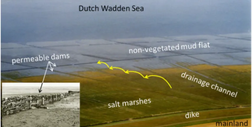
It is mainly the brushwood that dissipates waves. When sedi-mentation has reached a specific level, new basins are erected in front, thus building out into the sea, while vegetation starts to develop in the back, in the older basins (Fig. 1). Much of the contemporary salt mar-shes at the mainland of the Netherlands and Germany developed as result of this design, termed the Schleswig-Holstein method.
1.3. Permeable dams for coastal restoration
The basic philosophy behind permeable dams is to restore mangrove habitat by restoring the net sediment balance. The restoration of sedi-ment dynamics is being increasingly advocated as a pre-requisite for ecological restoration (Paola et al., 2011; Edmonds, 2012). The net sediment balance results from the difference between gross deposition and erosion rates, the latter two being orders of magnitude larger than the net effect (Winterwerp et al., 2013). A relatively small intervention in the coastal zone may therefore flip the net balance, initiating erosion or accretion. Permeable dams decrease wave activity, reducing wave- induced erosion, while enhancing gross sedimentation rates by trapping sediment-laden flows in their sedimentation basins. Dams are meant to be temporary and may become obsolete after mangrove rehabilitation. Their construction can be relatively cost-effective and low-tech, im-plying that they can be built and maintained by local coastal commu-nities, provided they have the basic training. This nature-based adap-tive approach can be regarded as an example within the Building with Nature (BwN) framework, applying natural forces in an integrated manner (De Vriend and Van Koningsveld, 2012; De Vriend et al., 2014), in concert with local communities to serve their socio-economic needs as well.
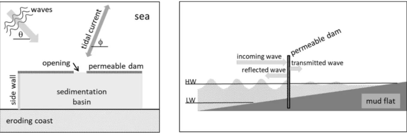
Fig. 2 depicts the definitions used for this BwN-approach in this paper. A permeable dam may have an opening and/or side walls, or not. Unless stated otherwise, all permeable dams consist of vertical poles supporting horizontally oriented elements, often brushwood. The area behind a dam is referred to as the sedimentation basin, also when side walls are absent. The (tidal) current makes an angle ϕ with the coast-line, and the waves an angle θ. Incoming waves are partly reflected, partly dissipated within the dam and partly transmitted. Mangrove habitat is generally found between MHW and high-high water spring (HHWS), though under very calm conditions mangroves may be found around mean sea-level (MSL) as well. Mudflat slopes are generally mild, i.e. of the order of 1:1000.
2. Examples of coastal rehabilitation projects
2.1. Guyana
The coastline of Guyana measures about 370 km. Ninety percent of the Guyana population lives in its low coastal plain, concentrated in the coastal area between the Essequibo and Berbice Rivers. This part of the coastline is mainly protected by earthen dams and concrete seawalls. The Guyana coastal system is characterized by a semi-diurnal tide with a 1 – 3 m range at neap and spring tide, respectively. In conjunction with the Guyana current, alongshore velocities towards the west of 0.2 – 0.5 m/s are induced. The climate is tropical and dominated by northeasterly Trade Winds. Also waves come from this direction, with periods between 8 and 10 s, and heights between 1 and 1.7 m, the higher values in the months November – March (Gratiot et al., 2007). The stability of the Guyana coast is governed by the about 30 km long mud banks migrating alongshore, colonized by mangroves at their landward side. Under the pressures of economic development, much of the mangrove-bearing coastal zone of Guyana has been transformed into settlements, agricultural land and aquaculture estates protected by coastal dikes. These defence structures are less effective in dissipating wave energy than mud banks. They also hinder the consolidation and subsequent mangrove colonisation of these banks, notably by enclosing mature mangrove forests and preventing propagule transport from these forests to mud banks (Anthony and Gratiot, 2012). East of the Berbice River and west of the Essequibo River, the mangrove-mud coast is generally in good condition, at locations more or less pristine. However, along the 80 km between these two rivers, in particular around Georgetown, mangrove forests have virtually disappeared, though may temporarily recolonize the coast when a mudbank ap-proaches (Figure 3).
The management and rehabilitation of mangroves in the coastal system falls under NAREI, the National Agriculture Research and Extension Institute. As a follow-up on the Mangrove Restoration Project, the Guyana Mangrove Restoration and Management Department was integrated within NAREI. Various rehabilitation pro-jects were initiated, amongst which: 1) Planting of mangrove and
Spartina grass, 2) Construction of sediment traps, permeable dams and
breakwaters, 3) Construction of restrictive gates and fences to reduce the impact of anthropogenic activities, 4) Community based mangrove management and livelihood initiatives such as tourism and beekeeping and 5) Extensive public awareness and education. Based on data from the most successful sites and comparison with the natural forest, NAREI has established a guideline for planting Avicennia germinans at 2.3 - 2.7 m above chart datum. During 2010-2018 over 500,000 seedlings were produced in community nurseries and planted along the coastline.
Permeable dams were constructed with local, resilient bamboo, which has a life time of about 3 – 7 years. The construction of the dams Fig. 1. Example of sedimentation basins and permeable dams in the Wadden Sea (The Netherlands) with details in inlay; yellow arrows indicate subsequent
was similar to the descriptions in Section 4. Figure 4 shows an aerial photo of some of the dams erected near Georgetown. The dams near Georgetown did not have durable results. However, along the left bank of the Essequibo River (Anna Regina and Devonshire Castle, west of Georgetown) 1.5 – 2 m siltation was monitored behind a 100 m long dam between 2013 and 2016. The higher siltation rate yielded bed levels a bit higher than the optima for mangrove rehabilitation. Part of the mangrove planting took place on these deposits.
2.2. Indonesia
Loss of mangrove habitat on the Indonesian islands is a major concern, as the archipelago depends largely on marine resources, thus on the ecosystem services provided by mangroves. Table 1summarizes these losses on four islands, based on 2010-data from the Indonesian Ministry of Forestry and Environment and 2015-data from the In-donesian Geospatial Data. Though considerable areas of mangroves were gained on Sumatra and Kalimantan, and to a lesser degree on Sulawesi, net losses are significant. Data from the Indonesian Ministry of Marine Affairs and Fisheries (MMAF) show that on Northern Java, more than 80% of the mangrove forests are damaged, directly affecting coastal stability: almost 750 km (44%) of the total 1690 km coastline is eroding, and in 2014 almost 130 km2 mangrove habitat was lost,
af-fecting more than 30 million people on Java alone. Though the majority of coastal erosion occurs in rural areas, the annual economic losses involved are estimated at 2.2 billion USD (MMAF, 2017a; Hendra and Muhari, 2018). Losses are attributed to urbanization, industrialization, conversion to aquaculture ponds, and subsidence. This rapid mangrove loss and degradation creates a strong imperative to restore mangrove forests and the ecosystem services they provide to coastal populations. In conjunction with national and local authorities, a first BwN-pilot in Indonesia for coastal rehabilitation with permeable dams was carried out in 2013 in Bogorame, a small village in Demak, central Java. Coastal erosion in Demak is severe, with land losses up to 100 m/yr as a result of wide-spread aquaculture in the one-time dense mangrove
forests, and because of subsidence. This coastal system is characterized by a diurnal tide with a few 0.1 to about 1 m tidal range, including a small semi-diurnal component. Wind, rain and waves follow seasonal patterns with the NW-monsoon from about November through April, with December through February being the wettest months. During these months, waves of about 5 s with offshore heights of typically 1.5 m erode the vulnerable coast further. This monsoon also drives an anti- clockwise residual current of 0.1 – 0.2 m/s in Demak coastal waters. The rest of the year, shorter waves are induced by a sea-land breeze, occurring in particular in the afternoons (MMAF, 2012).
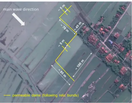
Two sedimentation basins were created by erecting permeable dams on the lost lands at the head of Bogorame, as this part of the village was severely at risk to erosion and flooding. Fig. 5 shows the remnants of the bunds previously forming the now-lost aquaculture ponds. The Fig. 2. Definitions used for the BwN approach, with (a) plan and (b) side view.
Fig. 3. Mangrove recolonization along the Guyana coast synchronizing with a migrating mudbank (dotted white ellipse).
Fig. 4. Mangrove recolonization along Guyana coast, east of Georgetown,
permeable dams were placed on top of these remnants, as they form a stable underground, reducing the risks of local scour. Construction of the dams was finished in November 2013. Fig. 6 presents the measured sedimentation volumes in the two sedimentation basins, showing a mean sedimentation rate of about 0.5 m in the four most dynamic months, whereas elsewhere erosion continued. Based on these pro-mising results, many more dams were constructed in Demak coastal area with a total length of more about 13.5 km, built and funded by various partners, with slightly modified designs, while still based on best engineering practices. Simultaneously, an extensive monitoring and basic research program was set up, in conjunction with a socio- economic development program with the local stakeholders (see Section 5).
Initially, these permeable dams trapped considerable amounts of sediment and overall, bed levels behind the dams raised. At some lo-cations spontaneous mangrove colonization was observed. Also, local communities planted Rhizophora in several sedimentation basins. Fig. 7 shows some photographs of the sedimentation patterns observed. First observations of longer term monitoring results indicate initial sedi-mentation behind the dams, but on the longer term sedisedi-mentation rates reduced considerably. More thorough analysis of these long-term re-sults was on-going at the time this paper was written. Over longer times, mangroves survived in only a few of the most protected sedi-mentation basins. Elsewhere, juvenile mangroves disappeared after one
or two years, most likely because the relative bed level dropped below mean sea level again. Apart from consolidation of the deposits, sub-sidence probably played a role, which was initially underestimated. Observational evidence and water-loggers revealed that subsidence rates of large parts of the coasts must be 0.05 m per year, or higher (Van Bijsterveldt et al., 2020c. Basically this implies that, over the project lifetime, the first dams, initially emerging above MHW, have subsided by 0.25 m or more, and are disappearing below MSL. These dams thus become less effective, and maintenance costs become higher, requiring more efforts to keep the dams in place.
In spite of these uncertainties and gaps in knowledge, the BwN- approach of coastal rehabilitation was adopted by the Indonesian government (MMAF, 2016 & MMAF, 2017b), and 6.3 km of permeable dams were constructed in 2017 at various locations on Java, and 1.7 km dam at Meranti (Sumatra). In 2018, another 3 km on Java, and 2 km permeable dams near Banyuasin (Sumatra) and 1 km near Penajam Paser Utara (Kalimantan). In 2019, another 1.5 km was built in Demak, and 9.5 km permeable dam at various locations in Sulawesi. As an example, Fig. 8 shows the permeable dams built in East Java.
Prior to the construction of permeable structures, a 150 m long seawall was built in Timbul Sloko using concrete cylinders. This seawall is locally known as the APO (Fig. 9), located along the original, pre- erosion coastline. Sedimentation behind the APO up to MSL took place in about two years, and one year later the first Avicennia seedlings were Fig. 5. First permeable dam pilot project in Indonesia in 2013, Bogorame, Demak.
observed. After that, the local community planted Rhizophora as well. In 2020, a mature, many meter high mangrove canopy has developed with both species, as shown in Fig. 9. As the APO is highly reflective, con-siderable scour took place in front, prohibiting seaward extension of the mangrove forest. Moreover, the APO is becoming unstable over time and some of its supporting structures have already collapsed. It is however a question whether a complete collapse of the APO would be problematic. The pile of concrete rubble would continue to dissipate wave energy, and the mangroves behind may well survive. If integrated with the coast behind, the construction of temporary hard structures, collapsing in a managed way, may therefore form an option in heavily degraded coastal systems, where waters are too deep for the application of permeable dams. Seaward extension of the coastline would then, of course, no longer be possible.
2.3. Suriname
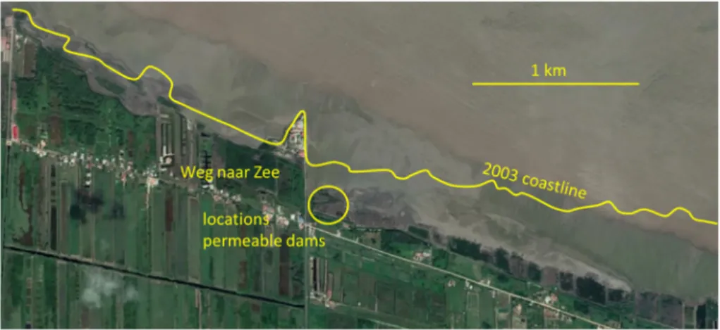
Suriname is part of the same coastal system as Guyana, together with French Guiana, and is characterized by the same hydro-sedi-mentological processes described in Section 2.1. The major part of the Suriname mangrove-mud coast is more or less pristine and in good condition. At large scale, the mangrove-mud coast alternatively ac-cretes and retreats by many kilometers with a periodicity of about 20 – 30 years (Augustinus, 1978, Augustinus, 2004; Anthony et al., 2010, 2019; see also Winterwerp et al., 2013). These dynamics synchronize with the migration of mudbanks along the coast: coastal reaches pro-tected by a mudbank accrete rapidly, whereas in between the banks, the coast retreats. Over longer time scales, the majority of the coast ac-cretes. However, at two locations, i.e. north of Paramaribo and further west, near Coronie, ongoing erosion occurs, likely as a result of man-grove conversion for agriculture and housing development (Winterwerp et al., 2013). In particular the erosion in the vicinity of “Weg naar Zee”, north of Paramaribo is problematic, as shown in Fig. 10.
Therefore a coastal rehabilitation plan was initiated in 2015, and a
series of permeable dams were constructed, as shown in Fig. 11, the locations of which are indicated in Fig. 10. Next to these constructions, a small-scale mangrove replanting program was executed in 2018. This work was mainly aimed at involving local stakeholders in mangrove rehabilitation efforts, and no systematic monitoring program was exe-cuted.
2.4. Thailand
The approximately 3,000 km shoreline of Thailand consists of about 1600 km sandy coasts, 330 km rocky coasts, over 1000 km muddy Fig. 7. 2019 sedimentation patterns, Bogorame, Demak, Java, Indonesia, photos December 2019 and January 2020.
Fig. 8. Example of permeable dams in Gresik Regency, close to Solo River, Java, Indonesia (photo by MMAF early 2019).
Fig. 9. APO, concrete seawall at Timbul Sloko, Demak, Indonesia (courtesy
COREM-UNDIP) with natural colonization by Avicennia (high vegetation) and planted Rhizophora (low vegetation).
coast, and the rest are other features such as inlets and estuaries (Department of Marine and Coastal Resources, 2017). For many dec-ades, coastal erosion is one of the chronic problems in the country. Along the upper Gulf of Thailand (GoT), coastal erosion up to 30 m/yr has been observed at some locations (Winterwerp et al., 2005). This coastline is mostly muddy and mangrove forest used to be abundant, but has been converted largely into aquaculture ponds. Five provinces along the GoT, i.e. Samutsongkhram Province, Samut Sakhon Province, Bangkok Metropolitan, Samutprakan Province, and Chachoengsao (Fig. 12) have struggled to stop erosion. Wave conditions are generally mild in the GoT, as follows from a hindcast of 20 years of wind data by
the authors using the JONSWAP method (Hasselmann et al., 1973; Kamphuis, 2010). Yet, offshore significant wave heights up to 2.5 m are predicted occasionally, in particular along the central part of the GoT around Bangkok Metropolitan and Samutprakan Province. Sa-mutsongkhram province and Samut Sakhon Province experience a milder wave climate with calm conditions for 90% of the time.
Coastal erosion along the upper GoT has been addressed by instal-ling low-crested revetments, sediment-filled geotextiles (“sand sau-sages”) and bamboo fences (Saengsupavanich, 2013). The latter con-stitute of single rows of vertically placed densely spaced bamboo poles (Fig. 13). Bamboo fences are functionally similar to permeable dams, Fig. 10. Coastal erosion around Weg naar Zee, Paramaribo, Suriname (Google Earth, 2019).
Fig. 11. Permeable dams constructed near Weg naar Zee, north of Paramaribo, Suriname (photos by E. Van Lavieren).
dampening waves and creating calm hydrodynamic conditions where sediment can settle.
During 1989 – 1993, at some locations Chachoengsao Province experienced coastal erosion rates > 70 m/yr. The local Sub-district Administration Organization (SAO) attempted to stop erosion by pla-cing sand sausages and bamboo fences, but was not successful due to the severity of the problem and limited budget. Later other govern-mental departments, including the Marine Department and the Department of Marine and Coastal Resources, have also placed sand sausages and bamboo fences. Again, the results were not satisfactory because the sand sausages sank into the soil. Experience with the bamboo fencing was not favorable as well, because (a) the bamboo lasted for two to three years, after which it decomposed into debris, (b) this debris drifted into the GoT, obstructing navigation and damaging the sand sausages placed elsewhere, and (c) part of the bamboo poles remains within the soil, wounding local fishermen collecting cockles and krill (Saengsupavanich, 2013; Pranchai et al., 2019). Debris can also damage the stems of landward mangrove vegetation, leading to observable degradation of the surrounding forest (Pranchai et al., 2019). From that time onwards, the SAO has hardly supported the construction of bamboo fences, but continued placing low-crested rock revetment. This technique proved more successful, while the growth of mangroves proved possible behind these revetments.
During 1995 – 2008, the average erosion rate at Bangkok Metropolitan’s coastline was about 8 m/yr. From 2008 to present (2020), Bangkok Metropolitan continued placing bamboo fences to stop further erosion (Fig. 13). However, here this technique also was not successful , and during 2008 – 2011, erosion rates of 9 m/yr were ex-perienced, despite the maintenance of the bamboo fences. During 2011 – 2013, erosion continued at rates up to 14 m/yr. Learning from the literature and Chachoengsao province’s experience, the Bangkok Metropolitan decided in 2014 to change their strategy and implement low-crested breakwaters instead. Thai law, however, requires to un-dertake an environmental impact assessment (EIA) for every type of breakwater, prior to construction. This EIA process is complicated in Thailand and took five years to complete, eventually being approved in February 2019.
Bamboo fencing appeared to be more successful though in Samutsongkhram and Samut Sakhon Provinces, and siltation rates up to 0.5 m in 28 months were reported anecdotally (Sukhothai Thammathirat Open University, 2013). Five years after the placement of the fences, the Department of Marine and Coastal Resources reported
evident mangrove growth behind the bamboo fences (Phiriyayatha, 2013). The department also elaborated on the proper selection of the bamboo, and how to involve local SAO and coastal communities in participatory construction (Sukhothai Thammathirat Open University, 2013).
Further south, along the west coast of Thailand, the coastal com-munity of Ban Klong Prasong, located on Klang Island in the Krabi River Estuary facing the open Andaman Sea has been impacted by coastal erosion and storm damage for many years (Enright and Nakornchai, 2015). The erection of a concrete seawall in 2003 by the Department of Public Works and of the Town and Country Planning, and its heigh-tening a few years later did not resolve flooding problems, but instead enlarged problems by water logging. Also replanting of mangroves (first
Rhizophora and later Avicennia marina) failed, with survival rates of
about 10% only. Therefore, under a previous Raks Thai project, com-munity members started to erect a 50 m long bamboo fence in April 2013, placed 50 m in front of the previously built seawall. Eight months later, about 0.15 m of sediment accumulated behind the fence (Fig. 14) The community planted Avicennia marina seedlings, of which 80% survived the first year. A double fence of 500 m length has been pro-jected in the area, but no long-term information is available.
2.5. Vietnam
The coastal zone of the Mekong Delta in Vietnam faces cumulative challenges such as urbanization, development of infrastructure, un-sustainable use of natural resources, population growth and increasing consumption. These challenges are exacerbated by the impacts of cli-mate change, i.e. (relative) sea-level rise, increased intensity of storms, and flooding, which ultimately result in erosion of the muddy coastlines (Carew-Reid, 2007; Schmidt-Thome et al., 2014; Schmitt and Albers, 2014; Joffre and Schmitt, 2019). Permeable dams were erected at various locations in the Mekong Delta. Their T-shaped design was based on experiments with a variety of configurations (Albers and von Lieberman, 2011), consisting of a long-shore and cross-shore part (Fig. 15), forming sedimentation basins of about 50×50 m2. The long-
shore dam dampens incoming wave energy (Fig. 16), while the cross- shore part is meant to reduce long-shore currents. In the longshore dams, openings of approximately 20 m were made to secure drainage and entrance of sediment-laden flow into the sedimentation basins. Flow velocities in the sedimentation basins are small, allowing the fine sediment to settle and consolidate – the latter is important for Fig. 13. a), (b), and (c) Bamboo fences along Bangkok Metropolitan coastline (d) drifted bamboo debris.
increasing stability against erosion and one parameter to assess the success of the measure (Albers et al., 2013).
Thus a total of 7,500 m of permeable T-shaped bamboo dams were installed on the east coast of the Lower Mekong Delta in Soc Trang and Bac Lieu Provinces (Fig. 15). In addition, 925 m of permeable dam was installed at the edge of the intertidal in Ca Mau Province between 2015 and 2016 (Fig. 16). The dams were about 1.4 m high, with their crest at MHW.
Two designs were tested in Soc Trang, a double row of bamboo fences filled with soft and another filled with stiff brushwood bundles. Wave measurements to quantify wave transmission through the permeable dams were carried out over a period of approximately six months to cover various storm and tidal conditions. Pressure transdu-cers were used to measure wave heights at two positions on the seaward and landward side of the bamboo dam, each about 5 m from the dam. The wave data were analysed and summarised in significant wave heights of 15-min periods (Schmitt et al., 2013), see Section 3.3 for the results. Flexible bundles were found more efficient in damping waves than stiff bundles; these can induce up to 80% reduction of the in-coming wave height.
Also the impact of these dams on floodplain restoration was mon-itored (Albers and Schmitt, 2015). For instance, in Bac Lieu Province a sedimentation rate of approximately 0.17 within seven months was
measured. The reduction of wave action within the sedimentation ba-sins also accelerates the consolidation of the deposited mud, thus in-creasing its stability against erosion. This is well demonstrated from mud density measurements at Soc Trang Province and photos of the landscape formed (Fig. 17). The colour of the mud and the natural re-generation of Avicennia alba indicate consolidation of sediment, de-veloping from the back of the sedimentation basins. On November 2012 the coast parallel elements of the permeable dams are still visible (Fig. 17). In February 2013 the beginning of sedimentation is observed. In November 2013 consolidation of sediments has started and natural regeneration of Avicennia occurred. The photo taken in January 2015 shows the growth of mangroves, which are no longer disturbed by wave action, owing to the elevation of the intertidal flats. Local stakeholder involvement also protects these mangroves from further anthropogenic effects.
3. Physical considerations
Before any detailed designs for construction can be made, as dis-cussed in Section 4, a conceptual design and long-term vison have to be setup. These should include the considerations in the following sec-tions.
3.1. System understanding
A key element for a successful application of permeable dams or any other intervention in coastal systems, is a good understanding of the geological, hydrological/hydrodynamic, morphological, sedimentolo-gical and ecolosedimentolo-gical elements, i.e. the natural system. On the basis of available data and a general understanding of coastal processes, a conceptual picture of the local sediment dynamics has to developed. Tidal ranges, direction and magnitude of tidal and residual currents, Fig. 14. Sedimentation and Avicennia marina behind the bamboo fence on
Klang Island, Thailand.
Fig. 15. Placement of T-dams in Bac Lieu Province, Viet Nam (courtesy Cong Ly and G.E. Wind, 2013).
Fig. 16. Wave dampening effect of bamboo T-dams in Ca Mau Province, Viet
direction, period and height of waves, and their recurrence are obvious parameters to be collected, in conjunction with coastal geometry and bathymetry, and sources and properties of (fine) sediment. Sediment availability in particular is of major importance in setting up a coastal rehabilitation plan, as this is a prerequisite for the rehabilitation of minerogenic mangrove habitats. In general, four sources of sediment in the coastal system can be identified:
1. Relic deposits from geological and biological processes. Geological deposits can be huge, providing a major source of coastal sediment. Examples are the Gulf of Bangkok, fed by sediments from the Chao Praya and minor Thai rivers, and the north coast of Java formed by terrestrial erosion of its many volcanos. Calcareous and marly muds, which are largely generated by marine organisms, are found in Florida, the Cayman Islands, Jamaica, Belize, the islands of the Great Barrier Reef, the coral islands of the west Indian Ocean, Yukatan and East Africa (Sauer, 1982),
2. Contemporary riverine input, local or remote. Though the majority of sediment has originally been brought to the coast by rivers, their contribution at the time scales of coastal erosion/rehabilitation is often small. For instance, only in the vicinity of larger rivers on Java (such as the Wulan, Demak), sediment input is considerable, in-itiating local delta formation. Exceptions are huge rivers, such as the Amazon in Brazil and the Fly River in Papua Guinea.
3. Longshore transport of sediment from riverine input or coastal erosion. Longshore transport of fine sediment is often small along muddy coasts. A major exception are the mud banks along the Guiana coastal system, dispersing Amazon sediment up to Venezuela.
4. Coastal erosion. With the erosion of mangrove-mud coasts, large amounts of fine sediment become mobilized, part of which remains in the coastal system for prolonged periods of time.
As many mangrove-mud coasts are under-researched, detailed hydro-sedimentological data are generally scarce. However, many free and/or global datasets exist that can be used to approximate coastal hydro-sedimentological dynamics. Appendix A provides some basic information on this. Next to these abiotic data, information on the local species of mangroves and their spatial distribution is required, together with data on the availability of propagules and their transport paths (Lewis III, 2005).
Of equal importance to the understanding of the natural system is insight into the causes and conditions of coastal erosion. Frequently encountered causes are:
•
subsidence, i.e. relative sea-level rise,•
conversion of mangrove forest into e.g. aquaculture ponds,•
urbanization and infrastructure, such as roads,•
coastal infrastructure, such as jetties and seawalls,•
water logging and/or loss of fresh water sources, and•
unsustainable wood harvesting.Though actual erosion events may occur under storm conditions, the
issues above generally reduce the resilience of a coastal system, and are therefore the root causes of coastal erosion.
3.2. Design philosophy and long-term vision
A major advantage of the erection of permeable dams along eroding mangrove-mud coasts is that these can be built offshore, i.e. there where land has been lost by erosion. If the dams function properly, (some) lost land may be regained through sedimentation. When the elevation has increased to a level where tidal inundation is below the threshold tolerance of mangrove species (Balke et al., 2011; Ball, 1988), the sedimentation basins are suitable for colonization by mangroves, and a next sedimentation basin in front can be installed by constructing new permeable dams further offshore (Fig. 1). Mangrove vegetation will then take over the role of the permeable dams and their main-tenance becomes obsolete. However, this is only possible if scour in front of the dams is limited, enabling regular sedimentation patterns in the basins without risks of water logging and/or too deep water un-suitable as mangrove habitat.
From a physical point of view, wave damping within a sedimenta-tion basin does not have to be complete. Wave energy has to be reduced to a point where sediment is no longer or only little remobilized during storms. Currently, we have no rules on how much wave energy has to be dissipated by the dams, though the conceptual “Windows of Opportunity” by Balke et al. (2011) may give some guidelines, pro-viding stresses which mangrove seedlings may survive.
Generally, coastal erosion is the result of decades of uninformed or even mis-management of the coastal system. Then, it is unlikely that rehabilitation can be achieved within a few years, even if the causes of coastal degradation have been stopped or reversed. This implies that patience and persistence is required by all parties involved (see also Chapter 5), requiring a long-term vision on the development of the coastal system, accounting for the physical constraints of the coastal system (e.g. sediment availability and pathways) and anticipating on the expected coastal developments, including further extensions sea-ward in due time, as in Fig. 1. Such a plan should include prioritizing of the locations of dam construction:
•
protection of life, housing and livelihood,•
protection of infrastructure, such as roads, service systems (water, sewage, …),•
protection of remaining fringes of mangroves.With respect to the latter, it may be an efficient strategy to try and built out from resilient stretches of mangroves, and/or from locations which are more or less stable, or accrete already. Of course, planning also requires securing stakeholder involvement, funds and possibly other boundary conditions over longer periods – we only touch shortly on stakeholder involvement in Section 5.
3.3. Wave damping by permeable dams
Waves approaching a permeable dam will be partly reflected, partly Fig. 17. Natural regeneration of Avicennia on restored floodplains in Soc Trang Province from the construction of the T-fences in October 2012 until January 2015
dissipated within the confines of the dam, and partly transmitted, as formalized by the following energy balance:
= + +
E Er Ed Et (1)
where E∞ is the energy of the incoming wave (E∞ ≡ ρgHs,∞2/8), with ρ is water density, g is acceleration of gravity, Hs the significant wave height, and Er, Ed and Et are the reflected, dissipated and transmitted wave energy (see also Fig. 2). A few experimental studies on wave damping through permeable dams have been reported in the literature, e.g. Mai et al. (1999); Sayah (2006); Haage (2018); and Jansen (2019). However, no generic design rules exist at present for dimensioning these permeable dams, though research is being carried out. Therefore, the formulation for wave attenuation by coastal vegetation by Dalrymple et al. (1984); Mendez and Losada, 2004 is used, assessing the work done by the wave-induced drag, integrated over water depth, neglecting vertical forces, and in which plants are schematized as ver-tical cylinders: = + E C DN k kh kh kh gk H 2 3 sinh { } 3 sinh{ } 3cosh { } 2 d d s 3 3 3 (2) where Ed is the wave energy dissipation [W], k and ω are wave number and frequency, h is water depth, N is number of elements, D is the characteristic diameter of cylinders/elements with effective drag coefficient per element Cd. Note that the porosity of this configuration reads ε = 1 − πND2/4, where n is number of elements per unit area.
However, the filling of brushwood structures consists of horizontal elements which may also exert drag in vertical direction to the flow. This is accounted for by Suzuki et al. (2019) by adding a vertical component to the dissipation term. As permeable brushwood dams are typically deployed close to the coast at small water depths, even the shortest waves behave as shallow water waves (i. e. c= gh) char-acterized by small to neglible vertical velocity components. Then the orientation of the elements is no longer relevant, see also Section 7. Thus, assuming negligible vertical drag forces, a relative damping rate can be derived by dividing Equ. (2) by (2g2/3π)ρC
dDN(Hs/2)3. This relative damping rate is plotted in Fig. 18 as function of water depth and wave period, showing that sensitivity to the wave period, thus length is not very large.
The rate of energy loss by wave dissipation is given by:
= Ec x E d d g d (3)
where cg is the group velocity of the waves. Integration and some ma-nipulation (see Dalrymple et al., 1984) gives the transmission coeffi-cient Hs,t/Hs,∞: = = + ++ k H H c DNH k L 1 1 t s t s D b s kh kh kh kh kh tot , , 4 9 , , (sinh ) 3 sinh (sinh 2 2 ) sinh 3 (4)
where Ltot is the thickness of the dam, Hs,t is the wave height trans-mitted through the dam, whereas Hs,∞ is the incoming significant wave height. Equ. (4) allows assessment of the wave dissipation that can be attained with a specific dam design, provided Cd is known, which is also a function of the wave period. For isolated cylinders, the drag coeffi-cient depends on (1) the ratio between wave excursion and cylinder diameter (Keulegan and Carpenter, 1958), denoted as the Keulegan- Carpenter number KC (≡U∞T/D = λw/D) or on (2) the Reynolds number ReD (≡U∞D/ν), where U∞ is the amplitude of orbital velocity
of incoming waves with period T and wave length λw, and ν is the viscosity of water. A number of studies have reported a reduction in drag coefficient for groups of cylinders under uniform flow, owing to a reduction of velocity and delayed flow separation from the elements (Nepf, 1999; Liu et al., 2008; Bokaian and Geoola, 2008). Heideman and Sarpkaya (1985) and Suzuki and Arikawa (2010) suggest that for multiple elements under waves, the ratio between wave excursion and element spacing determines the degree at which the flow approaching an element is hindered by the presence of surrounding elements, re-ferred to as sheltering. In more detail, modelling results by Etminan et al. (2019) suggest that sheltering only plays a role for element den-sities smaller than 0.016. When the element density increases, flow acceleration in between the elements yields narrower wakes and higher drag coefficients than in the case of isolated cylinders – the flow is blocked, and velocities in between the elements increase. Discerning whether sheltering or blockage governs the drag is essential to find the optimum element density for wave dissipation. At large KC, the
sensi-tivity of Cd to T decreases, and one may conclude that brushwood dam designs applicable under conditions of locally generated waves (e.g. Demak, Indonesia) are also suitable to more open coastal systems, characterized by swell, as in Vietnam. From an engineering point of view, optimizing permeable dam design implies maximizing the overall drag coefficient with a minimum of dam material, hence construction costs. However, it is stressed that the exact relations are not yet un-derstood, and more research is required for reliable predictive for-mulations.
In Vietnam, wave damping over flexible and stiff brushwood was measured in-situ over a period of six months, including storms with high waves. Fig. 19 presents the measured transmission coefficient kT in comparison to wave flume experiments, as a function of the ratio be-tween the freeboard of the dams Rc (see Fig. 31) and the incoming significant wave height Hs. The transmission coefficient kT is defined as the ratio of the mean transmitted wave height and of the incoming wave height (equ. (4)). The solid lines in Fig. 19 represent the best-fit through the measured values. The black triangles represent physical modelling data while the red squares and blue crosses in-situ mea-surements. Flexible bundles lead to smaller wave transmission coeffi-cients than stiff bundles, and thus have a larger wave dampening effect. On average, about 35% reduction of the initial wave height was mea-sured.
Finally, large blockage enhances the forces on the structures, in-creasing construction and maintenance costs, which is subject of Section 4 (see also Pranchai et al., 2019).
Waves along the direction of permeable dams are not hindered. It follows that the damping coefficients are reduced by a factor sin{θ}, for oblique waves (see Fig. 2).
3.4. Wave reflection
Further to Equ. (1) and Fig. 2, permeable dams do not only dampen waves, but also induce reflection. In the extreme case of a vertical impermeable structure (sea wall), full reflection occurs, and the am-plitude of the generated standing wave is twice that of the incoming wave. Bed shear stresses close to the structure then increase by a factor four with high risks of local scour at the foot of the sea wall. This is one reason that ample attention is paid in literature to wave reflection by coastal structures, as scour risks have to be minimized by costly bed Fig. 18. Dependency of relative wave damping as function of water depth and
protection. The degree of wave reflection is often given by the ratio of the heights of the reflected and incoming wave. However, we prefer a definition based on the ratio of reflecting and incoming wave energies (e.g. Yu, 1995), as energy is the preserved quantity, thus defining a reflection coefficient Kr = Er/E∞, where Er is the energy of the reflected wave, and E∞ of the incoming wave.
Relevant for the reflection by brushwood dams is the theoretical work by Dalrymple et al. (1991) on wave dissipation and reflection by vertical porous rubble mound walls. For shallow water conditions, they predict Kr = 0.2 – 0.4 for a porosity of ε = 0.4. Also Yu (1995) ana-lyzed wave reflection by thin vertical porous walls and found Kr ≈ 0.5 for a wide range of wall thicknesses (but all small compared to the wave length) – unfortunately, no information on the porosity of the walls studied was given. Laboratory flume experiments on regular arrays of cylinders were carried out by Haage (2018) for ε = 0.7 – 0.9 and by Jansen (2019) for ε = 0.6 – 0.9 at water depth of a few 0.1 m and wave
periods smaller than 2 s showing reflection coefficients of 0 – 0.4; the latter value for the more dense configuration (ε = 0.6). From field observations in Demak, a reflection coefficient of about 0.2 was esti-mated, at a porosity of about ε = 0.54. Though no detailed information on in-situ porosities of brushwood dams is available, we estimate re-flected wave energy at a few ten percent, maximal. Thus little scour in front of the permeable dams is to be expected, and new sedimentation basins in front can be designed efficiently.
Further to Section 3.4, reflection by oblique waves is also reduced by a factor sin{θ}.
Field observations on permeable dams in Demak during mild wave conditions showed wave damping between 20 and 80% (Gijón Mancheño et al., 2020), whereas a healthy mangrove forest may reduce wave heights by 0.2 – 1% per m vegetation (Horstman, 2014; McIvor et al., 2012, 2013). This implies that in sedimentation basins in front of e.g. dykes, wave reflection are likely to occur against these dykes, which may prevent sedimentation land/or mangroves colonization at the back of these basins. For instance, wave heights are doubled against a fully reflective seawall (100% reflection), thus erosive forces, scaling with the square of wave height, increase by a factor four. This implies that when less than 50% of wave energy is dissipated within a man-grove green belt, erosive forces at the back of that belt (in front of the seawall) are larger than at the coastline. This is sketched in Fig. 20, showing the effects of a fully reflective seawall/dyke within a mangrove forest at a location where 45% wave damping would have occurred in the undisturbed forest. As a result, mangrove stands are now attacked also from the back. If this would damage the forest, felling individual trees, wave damping further reduces, and wave attenuation increases further, etc. This sets a minimum green belt width of 50 – 250 m, de-pending on rate of wave dissipation by the mangrove vegetation for fully reflecting sea defenses. This is one reason that it is very difficult to rehabilitate mangrove habitat along solid dykes, as in some parts of the Guyana coast. Reflection-reducing features on such dykes/seawalls re-duces wave attenuation and may thus increase the success of mangrove rehabilitation in these environments.
Finally it is noted that permeable dams also deflect (tidal) currents owing to their hydraulic drag under stationary conditions (Gijón Fig. 19. Wave transmission coefficients of bamboo fences under various hydrological conditions (modified after Albers et al., 2013).
Fig. 20. Schematic of wave amplification by reflection against seawall, a)
Mancheño et al., 2020). This implies that fine sediment does not pass through these dams, or in small amounts only, if alternative pathways for the currents exist. Hence, their lay-out should be designed such that sediment can enter a sedimentation basin, as achieved for instance by the openings in the salt marsh works in NW Europe (Fig. 1).
3.5. Sediment trapping by permeable dams
The objective of permeable dams and bamboo fences is to create still (low dynamic) sedimentation basins, suitable for mangrove coloniza-tion. In this section, we presume that sediment is carried in suspension by the tidal flow towards these basins. The lay-out of the dams then follows from the local water depth:
•
If erected on intertidal areas, water movement, thus sediment transport towards and into the basins is primarily induced by tidal filling, thus by currents perpendicular to the coastline – this is the case in the Wadden Sea in NW Europe (Fig. 1), Indonesia, Solo River (Fig. 8), Thailand (Fig. 13 and 14) and Vietnam (Fig. 15, 16 and 17).•
If erected at deeper water (the basins are initially alwayssub-merged), water movement, thus sediment transport towards and into the basins is primarily induced by large-scale circulations, often with a profound component along the coast – this is the case in Demak, Indonesia, Fig. 5 and 7. It is noted, that dams in deeper water, submerged more or less permanently, also increases the risk of shipworm-induced damage (see below).
The dams in Guyana and Suriname have also been erected on in-tertidal flats, but sediment transport mechanisms are a bit different – see Section 3.6. This dependency of the transport paths of sediment as a function of water depth has profound implications for the configuration of the dams. On intertidal areas, the T-shaped dams (Fig. 1, 14, 15) are most effective as they allow sediment to enter the basins through the openings within the dams, and induce a drainage channel in a natural way, while preventing lateral losses.
In deeper water, one can profit from the large transport capacity by large scale circulations in the foreshore, bringing sediment efficiently towards the calm zone behind a coast-parallel dam, as sketched in Fig. 21. Side-walls (the T-dam configuration) would disturb these cir-culations, reducing sediment transport towards the sedimentation basin in the calm zone.
Data and modeling results on the sediment transport paths in Demak became available only after a substantial number of dams had been built. In hindsight, their configuration was not optimal as illustrated by the following observations, which exemplifies the need for a proper analysis of the coastal system.
3.5.1. Demak, Indonesia: shift from subtidal to intertidal
The strategy of a coast parallel dam in deeper water was followed in Demak, and indeed yielded many 0.1 m of sedimentation in the first monsoon season after construction. However, it was not anticipated that these sedimentation basins would become intertidal, thus blocking the large scale circulation, thereby blocking further feeding of the se-dimentation basin. In hindsight, T-dams should have been erected a year after construction around the newly formed intertidal basins al-lowing further sediment input and the generation of a drainage channel.
3.5.2. Wonorejo, Indonesia: lack of knowledge on current patterns
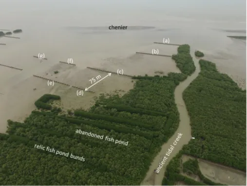
As an example of optimizing dam layout, the array of permeable dams constructed at Wonorejo, Indonesia, is further analyzed (Fig. 22), using the sedimentation patterns observed a year after their construc-tion. The entire bay left (i.e. west) of the tidal creek depicted in Fig. 22 consists of lost land, previously occupied by aquaculture ponds and historically vegetated by dense mangrove forest. A bit offshore, a small chenier is found (see below). Where possible, permeable dams were erected on the remnants of fish pond bunds for reasons of construc-tional stability. Our design philosophy was to build out mangrove ha-bitat from existing vegetation, but information on local current patterns was not available at the time. In hindsight, a shorter permeable dam (b), in conjunction with an extra dam between (b) and (c) would allow more sediment trapping between dam (b) and (c). An extra opening halfway dam (c) would allow more sediment transport to the area be-tween dam (c) and (d). Dams (f) and (g) are obsolete, and could better not have been built at all, as these block sediment transport towards the back of the bay.
The source of the sediment is local, i.e. mobile fine sediments stemming from erosion of the coast during previous events. The tidal creek does not bring any significant amounts of sediment to the coast. Its shape remains stable (for the time being) because of the sandy levees previously formed along its banks.
3.5.3. Bogorame, Indonesia: stimulating the formation of channels for drainage of the mangrove forest
The sediment deposits, in particular when becoming colonized by mangroves, will affect the current patterns further. These morphody-namic processes are ideally accounted for in the coastal rehabilitation long-term vision. Fig. 23 shows an example on how to stimulate the formation of channels within the deposits. Upon rehabilitation of the mangrove forest, such channels are required to drain the forest, pre-venting water logging.
3.5.4. Kien Giang, Vietnam: waves take and give
Next to the transport paths of sediment towards the sedimentation basins, its concentration is important, linearly affecting sedimentation rates. Suspended sediment concentrations are generally larger during storm, as high waves stir up sediment from the seabed. This is illu-strated in Fig. 24, showing measured sedimentation rates in five pilot plots in Kien Giang Province, at the very south of Vietnam (Cuong and Brown, 2012). This site faces the open ocean, and sea and swell are both important. At four plots various configurations of permeable dams were installed, closing off the sedimentation basins from the ocean (i.e. without openings in the dam). A fifth plot served as control. In the four pilot plots, about 0.1 m sedimentation was measured during the five months wet, wavy season. The open control plot experienced about 0.3 m sedimentation in the first two months, which was lost again though in the second half of the SW monsoon period.
These observations imply that:
•
Sediment transport and associated coastal rehabilitation takes place during the stormy season, as waves then stir up fines from the bed, being carried onshore by the tide,•
As waves also erode, the entire deposit in the control plot was lost Fig. 21. Permeable dam array constructed by MMAF at Gresik, Gresik Regency,again, probably because no more sediment was available in the foreshore to be stirred up by waves – thus sediment availability is a crucial parameter,
•
Thus waves take (erode) and give (mobilizing sediment), as pre-dicted by Winterwerp et al. (2005) – note that this is in particular true for the higher waves, smaller waves can erode the muddy bed, but mobilize too little sediment for mud flat buildup,•
The permeable dams are not entirely impermeable for sediment, but without openings trapping is less efficient. Thus sediment-laden water may be transported through permeable dams if alternative pathways are not available (water follows the path of least re-sistance),•
The permeable dams constructed did prevent erosion of sediment deposited behind the dams.Thus the important conclusion has to be drawn that coastal erosion and coastal accretion both take place during the wet, stormy season mainly, and it is thus the challenge to reduce erosion rates, while
maintaining, or enhancing sedimentation rates at the same time (see also Winterwerp et al., 2005).
3.6. Mud streaming by waves
Many mud coasts exhibit thicker or thinner layers of soft, fluid mud (e.g. Metha, 2013). Along the Guiana coast in northern South America, fluid mud forms an inherent part of the coastal system and the migra-tion of Amazon-borne mud along the coast in the form of mud banks (Anthony et al., 2010). In Indonesia, soft mud is formed at locations by remobilization and accumulation of eroded coastal sediment, as in Demak. Such soft mud layers are known to dampen waves efficiently by viscous dissipation, e.g. Gade (1958); Wells and Kemp (1986) and Kranenburg et al. (2011). In the direction of wave damping, so-called radiation stresses are induced (Longuet-Higgins, 1953; Sakakiyama and Byker, 1989; Rodriguez and Mehta, 1998), propelling the soft mud (Motohiko and Shintani, 2006) in the direction of wave propagation. This process is known as streaming. Streaming forms one of the major Fig. 22. Arrays of permeable dams at Wonorejo, Demak, Java, Indonesia (WI drone image, 2019).
mechanisms in onshore fine sediment transport at the leeside of the mud banks in the Guiana coastal system.
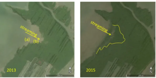
Fig. 25 shows an example of the large transport rates induced by streaming and the corresponding large sedimentation rates. Mangrove habitat was rehabilitated naturally in about 1.5 year, and rapidly co-lonized when the conditions became favorable. During a site visit in 2013, fluid mud thicknesses from a few 0.1 m at location (a) to more than a one meter at location (b) were observed.
It is obvious that erecting permeable dams in this area would be counter-productive, killing the onshore sediment transport, as it kills the driving force. This process was unknown and unforeseen at the time of installing a permeable dam some 100 m offshore from location (a), stopping the natural accretion at this location. Borsje (2017) elaborated further on the role and dynamics of streaming in the fine sediment dynamics in Demak coast, and conditions at which streaming may be expected.
3.7. The role of cheniers
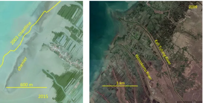
Fig. 26 and further inspection of Google Earth images reveals se-dimentary ridges along the Demak coastline, the majority at the 2003 pre-erosion coastline. Visual inspection during site visits (Tas et al., 2020) shows that these ridges consists of sand lenses sitting on an otherwise muddy substrate. Particle sizes were estimated at about D50
= 200 μm at the windward side to about 100 μm at the ridge leeside. We therefore refer to cheniers (e.g. Augustinus, 1989; Otvos, 2018), which may or may not be attached to the shore. Cheniers are en-countered along many coastlines across the world (Holland and Elmore,
2008), such as in Suriname and West Africa, where over time they may form terrestic sand ridges in the landscape. Paramaribo, for instance, was initially built on such ridges.
In the Demak coastal system, cheniers have a width of the order of 100 m, with a top above MSL, commencing below low water. Some of these cheniers are formed from coastal processes on riverine input of sand in the coastal area (Fig. 26, right panel). Other cheniers are likely being formed by local sorting and subsequent self-organization of se-diment previously eroded from the coastline (e.g. Augustinus, 1989). Over longer time scales, this sand of course has been brought into the coast system by the various rivers on Java.
As these cheniers are much steeper than the otherwise muddy coast, waves break at their windward side, losing considerable energy. They do therefore play an important role in mudflat development and the protection of the vegetation behind, as shown by the analysis by Van Bijsterveld (2015, Van Bijsterveldt et al., 2020a). Along the coast of Suriname, cheniers form ridges in between the mud banks of many meters height, protecting the hinterland. Note that at the location of Fig. 26 no chenier was encountered where streaming occurs.
The formation and dynamics of cheniers and their migration are largely unknown. Tas et al. (2020) collected data on chenier dynamics, mainly under quiet hydrodynamic conditions (0.2 m waves). They tested some hypotheses with mathematical models, and it is postulated that the large tidal volume behind this chenier presumably augments its dynamics largely. However, no data could be collected during storm conditions. Fig. 27 exhibits the importance of such storm conditions, showing how a cheniers moved about 100 m onshore within one to two weeks. Likely, its further migration is blocked by the permeable dam. Fig. 24. Measured sedimentation rates in Vietnam pilot plots – from GIZ, Practical Experience from Kien Giang Province, 2012.
At other locations, it was observed that upon landing on the coastline, cheniers suffocated existing mangrove vegetation. On the other hand, mature trees have been found on older sand riches along the coastline. Apparently, mangroves can colonize these more sandy substrates as well, hence forming a sustainable and solid protection of the mangroves behind, as for instance in the Guyana’s in South America. However, no detailed information is available on the time scales involved.
Though basic research on the formation and dynamics of the che-niers in Demak is still going on, it is anticipated that these detached cheniers are a temporary phenomenon. If formed from local sorting of eroded sediment, its source will become depleted one day, while pre-viously formed cheniers will have landed on the coastline, as observed with the chenier systems in the Guiana coastal system.
4. On the construction of permeable dams
In the following sections, the lessons-learned on constructing permeable dams in Demak, Indonesia are summarized. Their designs were partly based on the experience gained in Vietnam by GIZ (Von Lieberman, 2012). This section is based on the more comprehensive “Technical Guidelines Permeable Structures” (Wilms et al., 2018). These dams consist of horizontally placed brushwood, which mainly damp the waves, and vertical poles to hold the brushwood, as in Fig. 1. Most of the issues addressed are directly applicable elsewhere. The permeable dams need to stay in place long enough for mangroves to take over, which period is determined by the sediment accretion rate (in Demak, estimated at 2 – 5 years) and rate of mangrove recovery (in Demak, estimated at 3 – 5 years). A crucial aspect appeared the in-volvement of local stakeholders in construction, inspection, main-tenance and repairs. This issue is further addressed in Section 5. Fig. 26. Example of chenier formation Demak, Indonesia (Google Earth image) by (a) self-organization of eroded coastal sediment and (b) riverine sand input.