Protecting fossil sites in New Zealand
[Sauvegarde de sites fossilifères en Nouvelle-Zélande]
Bruce W. H
AYWARD1Citation: HAYWARD B.W. (2009).- Protecting fossil sites in New Zealand.- In: LIPPS J.H. & GRANIER B.R.C. (eds.), PaleoParks - The Protection and conservation of fossil sites worldwide.- Carnets de Géologie / Notebooks on Geology, Brest, Book 2009/03, Chapter 05 (CG2009_BOOK_03/05) Abstract: New Zealand has a rich and diverse heritage of fossil sites pertaining to every epoch from the Cambrian to the Holocene. An Inventory of the 313 fossil sites considered to be the scientifically and educationally most important was compiled in the 1980s and many of these are now protected within a range of reserve types, ranging from World Heritage and National Parks down to small local Scenic Reserves. Legal covenants have been used in just a few instances by private landowners to protect sites on their properties in perpetuity even after they have sold the land. In recent years the Resource Management Act (RMA) has been more widely used to achieve a lower level of planning protection for many of New Zealand's important fossil sites, as well as many other earth science features. A methodology is presented for objectively assessing the heritage values of earth science sites to justify their being scheduled on District Schemes (under the RMA) as outstanding natural features warranting protection from the adverse effects of developments. Scheduled sites may be on public or private land and dependent upon their fragility or robustness, certain development activities are prohibited, others require permits from the territorial local authority and others are allowed without a permit. Because of the inordinate cost of land purchase for reserves, planning protection under the RMA is likely to be the dominant method for protecting New Zealand's fossil sites in the future.
Key Words: New Zealand; earth science conservation; geopreservation; fossil sites; planning protection.
Résumé : Sauvegarde de sites fossilifères en Nouvelle-Zélande.- La Nouvelle-Zélande possède un ensemble de sites fossilifères où sont représentés tous les étages du Cambrien à l'Holocène. Un inventaire des ces 313 sites classés selon leur intérêt scientifique et pédagogique a permis dans les années 1980 leur classement en sites relevant du Patrimoine mondial, du statut de Parc National ou de simple parc local. La gestion est parfois confiée à des instances privées qui ne sont pas toujours les propriétaires du lieu. Ces derniers temps, l'adoption du Resource Management Act (RMA) a largement servi de base à la sauvegarde des sites fossilifères et plus généralement de tout site d'intérêt scientifique. Nous présentons une méthodologie d'évaluation et de classement des sites par districts en vue de garantir leur protection. Selon leurs caractéristiques, les sites peuvent être privés ou publics, à accès libre ou restreint. La mise en application du RMA paraît être la meilleure méthode de protection des sites naturels en les soustrayant aux variations incontrôlables du coût de la propriété foncière. Mots-Clefs : Nouvelle-Zélande ; patrimoine des sciences de la terre ; sauvegarde géologique ; sites fossilifères ; planification de la protection.
1 Geomarine Research, 49 Swainston Rd, St Johns, Auckland (New Zealand) b.hayward@geomarine.org.nz
Manuscript online since September 17, 2009
Introduction
New Zealand, situated on its own in the Southwest Pacific, has a rich and diverse geology, not only in volcanic, geothermal and tectonic areas, for which it is best known, but also in its marine sedimentary and fossil record. In its relatively small area (268,680 km2) there
are outcrops of marine sedimentary rocks of every epoch since the Cambrian (Fig. 1) and a complete, or virtually complete, record of geological time since the late Paleozoic.
New Zealand's location along the Pacific-Australian plate boundary has resulted in outcrops of uplifted deep marine sedimentary rocks, as well as shallow water examples, right through into the early Pleistocene. Terrestrial and freshwater sedimentary sequences are less
extensive but still provide a reasonable record of vegetation, but not of non-marine animals, since the Triassic.
Although no New Zealand fossil sites are likely to reach iconic World Heritage status in their own right, they do provide a window into the unique evolutionary history of this part of the world. Initially this biota lived along the New Zealand-New Caledonia coast of Gond-wana, but following Cretaceous breakup of this southern supercontinent the fossils record terrestrial and marine evolution on and around the New Zealand "ark" set adrift in the Southwest Pacific. New Zealand's Cenozoic marine fossil record is arguably the most com-plete and diverse in the Southern Hemisphere, certainly in the South Pacific.
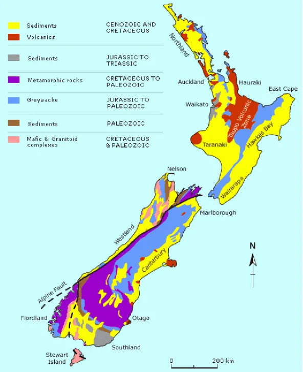
Figure 1: Simplified geological map of New Zealand showing location of unmetamorphosed or weakly metamor-phosed sedimentary rocks that contain fossils.
New Zealand paleontological
research
The study of New Zealand's rich fossil record began soon after European colonisation in the mid nineteenth century and flourished in the middle and late twentieth century with the establishment of dedicated macro- and micro-paleontological and palynological positions and national collections at the New Zealand Geological Survey (NZGS), now GNS Science. Other major paleontological research emanated from studies centred around paleontology lecturers at the Universities of Otago, Canter-bury, Victoria (Wellington), and Auckland. Today the bulk of New Zealand's fossil heritage and its biostratigraphy has been documented in scientific papers and especially in the NZGS Paleontological Bulletins (65 numbers) and its
recent successor in GNS Monographs. New Zealand paleontology is now in a phase of higher resolution studies to improve its biostra-tigraphic, paleoclimatic and paleoenvironmental utility. Taxonomically rarer elements of the fauna and flora are still being discovered and documented, particularly our sparse vertebrate fossil record.
In the early-mid twentieth century New Zealand paleontologists recognised that they couldn't use Northern Hemisphere biostrati-graphy to date New Zealand sequences, and so a whole set of New Zealand-specific biostra-tigraphic stages was established, based largely on mollusc and foraminiferal successions (e.g. FINLAY & MARWICK, 1947). These proved to be the key to unlocking an understanding of the complex Cretaceous-Cenozoic tectonic and
paleogeographic history of our country in the mid twentieth century (e.g. FLEMING, 1979). Today these stages are still used, but are pro-gressively more integrated with and calibrated to international time scales (e.g. COOPER, 2004).
Values and management of
fossil sites
The types of protection and management needed, if any, to ensure the long-term survival of any fossil site depends upon why it is impor-tant and what aspects are of scientific, educational or aesthetic value.
SITES VALUED FOR COLLECTING
Sites valued largely for collecting fossils include all important microfossil and palyno-logical exposures, biostratigraphic type and reference sections, and many robust or rapidly weathering or eroding macrofossil sites. For many of our man-made exposures and rapidly eroding natural sites, collection of important macrofossils as they are exposed (and their lodgement in a publicly accessible collection) can be regarded as one form of protection, as many survive only a short time before they weather or erode away.
These sites need to be kept fresh, free of vegetation and other obstructions, and be available for fossil collection (some with, others without a permit). With natural exposures this is usually best achieved by ensuring that natural erosive processes continue. With man-made exposures, such as road cuttings and quarries, this may require periodic removal of weathered material. Often these are the hardest sites to convince authorities to protect. It can be hard to argue for the protection of a bare face of rock simply because it contains unseen microfossils; or having persuaded authorities that protection of a robust, rich fossil site is warranted, persuading them that non-commercial fossil collection should be allowed without (or sometimes even with) a permit can be difficult.
SITES VALUED FOR THEIR IN SITU SETTING
Sites of this type include most macrofossil sites with strong paleoecological and paleoenvi-ronmental values. These require study and documentation of the relationship of the fossils to each other and to stratigraphic and sedimentological features. These sites are those where the fossils lose most of their value if collected and taken out of their setting, or where the fossil site has educational or aesthetic values. Sites of this type include most in situ fossil forests and trace fossil sites. If these sites are not eroding or weathering rapidly, they should have strong protection with limited collection only permitted on strong scientific grounds.
Threats to fossil sites
DEVELOPMENTIn common with most earth science featu-res, fossil sites can be lost through all forms of development, both large and small. These range from dam construction and urban spread, through the development of transport corridors and quarrying, to the erection or retaining walls and concrete or grass seed spraying of exposu-res. The anomaly is that in many instances some of our best fossil sites have only been exposed because of development-related activi-ties. A major difficulty is arguing for retention of some of these man-made cuttings, which much of society, including the biological conservationists, consider to be ugly eye-sores "needing" restoration.
NEGLECT
Many of our important fossil sites are stu-died or collected infrequently (e.g. once every decade). Between these visits many exposures (especially those that are man-made) become overgrown or weathered through neglect. While it may be possible to argue for periodic vegeta-tion clearance or bulldozing for sites visited regularly, especially by educational classes, it is more difficult to do so for those less visited.
COLLECTING
While recognising that collecting often "saves" our fossil heritage (see earlier), this needs to be balanced against the need to protect in situ values. Fossil sites need to be classified into:
1. those that are large and continually eroding and therefore robust enough to sustain ongoing educational collecting unencumbered by a bureaucratic permit system; and
2. those that are fragile (small, hardly eroding and with in situ values) where even uncontrolled scientific collecting can be extremely damaging.
In New Zealand, commercial fossil collecting is minor – probably because we do not have many of the charismatic fossils of some parts of the world – like dinosaur bones, amber fossils, ammonites. Unlike some countries, New Zea-land has no overall ban on the collection, ownership or export of fossils, although legislation does control the export of type and iconic specimens. If large-scale collection and sale of fossils is to be permitted, it should be confined to source areas like quarries where the fossils would otherwise be destroyed.
Protecting New Zealand fossil
sites
As in most other countries, increasing popu-lation and associated developments in New Zealand are progressively encroaching over and modifying the countryside with resultant dama-ge or loss of some important earth science features. New Zealand's fossil heritage is not exempt, and in some instances is more fragile and prone to damage and loss than many other earth science features.
There are many forms and levels of legal protection available for protecting New Zeal-and's fossil heritage, and all have been used to varying degrees, but there are still many unprotected sites that should be included in the system.
EXPORT CONTROLS ON NEW ZEALAND FOSSILS
In general New Zealand fossils in the field belong to the landowner, and permission to collect should be sought from them. Fossils on public land that is not in a reserve are generally available for anyone to collect and own. The Protected Objects Act, 2006 (URL:
http://www.mch.govt.nz/protected-objects/index.html), defines several categories of fossils as protected objects, that require a permit from the Ministry for Culture and Heritage for export out of New Zealand (even if on loan). These protected fossils are all the type specimens of all New Zealand-based fossils and "a fossil or part thereof including any developmental stage, shell, or skeletal or supporting element, of which there is not a sufficient selection in New Zealand public
collections to define the variation, range, and environmental context of the taxon or object."
RESERVES AND PARKS
The Reserves Act 1977 provides "for the preservation and management for the benefit and enjoyment of the public, areas of New Zealand possessing (...) natural, scenic, (...) geological, scientific, educational ( ...) features of value; ensuring ( ...) the preservation of representative samples of all classes of natural ecosystems and landscape which in their aggregate originally gave New Zealand its own recognisable character".
The National Parks Act 1980 provides "for the preservation in perpetuity (...) areas of New Zealand that contain scenery of such distinctive value, (...) and natural features so beautiful, unique or scientifically important that their preservation is in the national interest".
The Reserves Act provides for various cate-gories of reserves, having different levels of protection depending upon the reserve's values and uses.
World Heritage status. New Zealand has
three formally approved World Heritage sites. Two have been established for their spectacular volcanic and glaciated landforms, but none of the three contain any identified world heritage status fossil sites. Indeed it is unlikely that any New Zealand fossil sites would qualify for World Heritage status. Nevertheless there are three significant fossil sites (Table I) that incidentally occur within two of the three New Zealand World Heritage areas and therefore enjoy the highest level of protection.
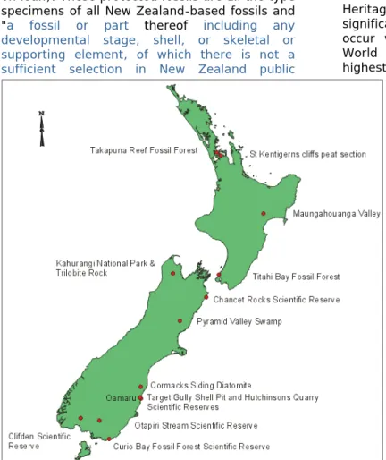
Figure 2: Location of important fossil sites mentioned in the text.
National Parks. New Zealand
has 13 National Parks (10% of country) largely protecting our more rugged and wilderness areas, composed predominantly of meta-morphic, plutonic and volcanic rocks. All are relatively large areas in natural vegetation and no fossil sites would qualify for this status on their own. Once again there are a few (11) fossil sites that have a high level of protection because of their incidental occurrence within one of our National Parks.
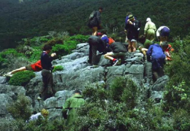
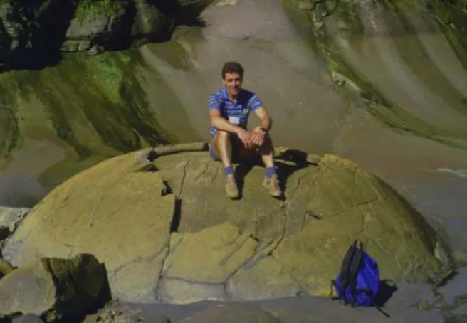
One of the most recently established national parks, Kahu-rangi (Fig. 2), includes most of the outcropping areas of pre-Permian Paleozoic rocks in New Zealand. Thus included within the park are many of our most important Cambrian (Trilobite Rock), Ordo-vician (graptolites) and Devonian fossil sites (Baton River). Trilobite Rock in the Cobb Valley is one
of the few fossil sites in a National Park that is a tourist attraction, as it is well known as containing New Zealand's oldest fossils. Until the area was gazetted a reserve, the 1000 m2
marble Trilobite Rock (roche moutonee) was damaged by extensive collecting, including the use of explosives on at least one occasion. Despite this, it is still largely intact (Fig. 3). It probably would have been more severely damaged if the trilobites it contains were more abundant and less fragmentary.
Figure 3: Trilobite Rock is well-known for New Zealand's oldest accessible fossils (Middle Cambrian). Prior to the creation of Kahurangi National Park in the 1990s, Trilobite Rock was damaged by collectors using explosives, but today it is a much-visited tourist attraction.
Nature, Marine and Scientific Reserves.
These three reserve types have the most stringent level of management and protection of all categories. For some access is only allowed by permit for scientific research, while all others have strict by permit-only controls on all forms of collection or damage. Nature and Marine Reserves are established mainly to protect natural ecosystems, and fossil sites within them attract the same level of strict protection, no matter what their values.
Scientific Reserves, on the other hand, are established primarily to protect an area for research purposes or to protect earth science features. Six of the earth science-based scientific reserves have been established to protect their fossil and biostratigraphic values and all are in the South Island (Table II, Fig. 2).
Curio Bay Scientific Reserve (Fig. 4) protects a 100 m-stretch of intertidal reef and low cliff containing remains of several Jurassic forests, with numerous in situ tree stumps and large fallen trunks (POLE, 1990). This is the best known fossil forest in New Zealand and the country's most visited and tourist-promoted fossil site, although yellow-eyed penguins wandering among the fossils sometimes divert tourists attention.
Four of the other five fossil-based scientific reserves were established in the 1970s-1980s through the energies of sympathetic managers of the local office of the Lands and Survey Dept (which at that time was responsible for
crown-owned reserves). Two protect small, former quarry face exposures of rich early Miocene brachiopod and mollusc fossils and the type localities of many species (Target Gully Shell Pit; Hutchinsons Quarry; HORNIBROOK, 1990). The other two protect the holostratotype sections of a local New Zealand Triassic biostratigraphic stage (Otapiri Stream), and of four, foraminiferal- and mollusc-based New Zealand Miocene stages (Clifden; HAYWARD, 1988).
The last fossil-based scientific reserve (Chancet Rocks) was established by Lands and Survey Dept. following submissions form the Geological Society of New Zealand to protect what were then inferred to be spectacular Cretaceous sponge fossils (LEWIS, 1984), but subsequent studies have reinterpreted as concretions around burrows (Paramoudra). More recent study has now identified a Cretaceous-Tertiary boundary section through this Scientific Reserve (LEWIS, 1984).
Figure 4: The Jurassic fossil forests at Curio Bay in Southland are protected within a Scientific Reserve.
Scenic Reserves, Regional Parks, Conservation Parks. These are the most
common categories of mostly smaller reserves and they occur throughout all parts of New Zealand. All plants, animals and landforms are protected within these reserves but the level of protection for rocks and fossils is variable, with permits required for collection in some but not in others. Many important fossil sites enjoy protection from larger scale developments through their incidental location within these reserves, but a number are still open for collecting. Law requires that all these reserves have management plans (with opportunities for public submissions) that should identify areas with heritage values that should be protected and areas that are suitable for the development of infrastructure for visitors and park management. Thus the occurrence of a fossil site within the boundaries of these reserves does not automatically ensure its long-term preservation. Its location, values, and suitable forms of management (e.g. vegetation clearance) need to be specified in the reserve's management plan.
Figure 5: Number of significant fossil sites of different ages listed in the New Zealand Geopreservation Inventory. Sites spanning more than one epoch are included in each age category.
In 1990, several crown land management agencies (Lands and Survey Dept, NZ Forest Service, NZ Wildlife Service) were combined to form the Department of Conservation (DoC), which now administers and oversees the creation and classification of all crown-owned reserves. Public input into these processes is provided through the existence of the New Zealand Conservation Authority and 14 regional Conservation Boards. These entities consist of central government-appointed members of the public, nominated by conservation, recreational, tourist, scientific and other groups, and Maori iwi, who provide advice on conservation policy and how DoC should spend its limited budget.
Regional Parks and some Scenic Reserves are owned and administered by regional and local councils with high-level management by representatives elected by the population in the region, district or city.
COVENANTS
These provide a different kind of legal protection with the land remaining in provate ownership. The Queen Elizabeth II National Trust Act 1977 encourages and promotes the provision, protection and enhancement of open space for the benefit and enjoyment of the people of New Zealand. Open space includes any area "that serves to preserve (...) landscape of aesthetic, (...) scenic or scientific (...) interest or value." With the owner's agreement a covenant is placed on the land title that protects in perpetuity a specified area, even when the land changes ownership. These covenants are usually used to protect areas of native forest on farms, but they have also been used to provide protection for smaller landforms, such as karst areas.
There are two important fossil sites that have QE II open space covenants (Table I). In the South Island, Pyramid Valley swamp is covenanted because of its value as the site of numerous intact fossil moa skeletons (Fig. 6), some of which have been delicately excavated and even have gizzard contents preserved that show the food of these large, flightless, extinct birds.
Figure 6: Moa bones. New Zealand's endemic flightless moa were killed off by Polynesian colonists a few hundred years ago. Several important Holocene moa bone-bearing fossil sites in caves and swamps are protected within reserves or with covenants.
Figure 7: Mangahouanga Stream is the most important source of Cretaceous vertebrate fossils in New Zealand. For this reason it has been covenanted by the private forest owners under the QEII Open Space Covenant system to protect access in its natural setting for future generations.
The other covenanted fossil site is Mangahouanga Valley, Hawkes Bay (Fig. 7), where numerous large concretions in the river bed have been found to contain the bones of a number of late Cretaceous dinosaurs, mosa-saurs and plesiomosa-saurs. Until recently this was
the only locality in New Zealand where land dinosaurs had been found (KEYES, 1984). It has taken nearly 20 years of patient attempts to achieve this level of protection, with the
plantation forest owner eventually being persuaded to protect the concretion-rich part of the valley in native forest and to allow collecting only by bona fide researchers.
Table I: Numbers of important fossil sites (listed in the New Zealand Geopreservation Inventory) protected within different reserve types.
Table II: New Zealand Scientific Reserves (SR) established to protect fossil sites. Imp. = scientific or educational importance assessed in the NZ Geopreservation Inventory as A = international; B = national.
PLANNING PROTECTION
Although many of New Zealand's important fossil sites are protected within reserves, a far greater number occur on private or public land (e.g. road and rail cuttings, river banks, coastal shore platforms and cliffs) that have no reserve status. Fortunately there is another level of protection that can be provided under our land planning laws. This is through the planning and consent processes of the many territorial local authorities (Cities and Districts) using the Resource Management Act.
The purpose of the Resource Management Act (RMA) is "to promote the sustainable management of natural and physical resources". Section 6(b) states that "the protection of outstanding natural features and landscapes from inappropriate subdivision, use, and development" is a matter of national importance. Outstanding natural features include fossil sites. The RMA provides for national policy statements to guide local authority plans. Among the national priorities set out in the New Zealand Coastal Policy Statement 1994, is the protection within the coastal environment of "visually or scientifically significant geological features" (Policy 1.1.3a).
It is through the planning process in each district or city that the majority of important fossil sites have been given some protection in the last 15 years. The process involves the preparation of a draft District Scheme, followed
by public submissions, cross-submissions, local body decisions and possibly appeals to the Environment Court. All local authorities are required by the RMA to have an operative district scheme that is updated every 10 years, through a further round of public consultations.
Some district schemes provide broad criteria for identifying "outstanding natural features", so they can be protected from damaging activities, all of which require a resource consent before they can proceed. Other schemes provide more certainty as to which sites are outstanding and need protection by listing them as a schedule in the scheme. Indeed more and more schemes are moving towards scheduling of outstanding features. In the last decade the Geological Society of New Zealand has had considerable success in having hundreds of geological features (including many fossil sites) and landforms scheduled in district schemes.
The proposed scheduling of a site can be challenged and appealed should the landowner or other interested party be opposed. In these instances the challenge for the local authority or geological community, who may have propo-sed or supported a scheduling, is to prove in a court of law (Environment Court) that a site does indeed qualify as an "outstanding natural feature".
Table III: New Zealand fossil sites ranked as internationally significant (A) in the New Zealand Geopreservation Inventory.
The New Zealand
Geopreservation inventory
Well before enactment of the Resource Management Act, the Geological Society of New Zealand had realised that the greatest impediment to protecting our earth science heritage, including outstanding and repre-sentative fossil sites, had been a lack of readily accessible information on exactly which these sites were. As a result compilation of the New Zealand Geopreservation Inventory was begun.The inventory now contains 3400 sites country-wide and is largely complete. It is fully computerised with a wide variety of data about each site, including an assessment of its
scientific, educational or scenic importance (291 have an international ranking, 1357 national and the remainder regional). Sites have also been assessed for their vulnerability to complete destruction or major modification by human activities, and their current protected status documented. The Inventory is main-tained by the Geological Society of New Zealand with a copy held by the Department of Conservation in Wellington.
Regional Inventory listings have been produced and distributed to all land management agencies and conservation groups in the country. This information now forms the basis for identifying the outstanding natural features scheduled in District Schemes. Indeed
some District Schemes define their scheduled sites as being those listed in the inventory as of a particular year, whereas it would be preferable if sites were individually scheduled and their extent legally surveyed.
Initial compilation of the inventory was undertaken in 15 categories – one of which was fossil sites. All New Zealand paleontologists were asked to nominate sites for inclusion and the first draft list was circulated seeking comment, particularly to ensure that the best representative examples of fossil sites form each era and of each fossil group were included. Twenty-eight paleontologists then provided information to fill the inventory fields that identify each site's location and extent, its scientific and educational significance, more detailed description, together with information on age, land management, references and informants. The most experienced paleontologists with an overview of most of New Zealand's fossil sites of different ages were also asked to rank the scientific importance of each site, as international, national or regional.
The first compilation was completed in 1987 (HAYWARD & WARD, 1987), but the compiled results of this category have never been made publicly available, as it was considered that it would provide an easy guide to the best fossil sites in New Zealand, that might be un-scrupulously used by a commercial collector. Individually the location of all sites have been published in the literature and listed in the New Zealand Fossil Record File (URL:
http://www.fred.org.nz/) but using these
sources a commercial collector would have to do a lot of work to find sites and this gives them a level of protection.
The 1987 compilation of fossil sites category contained 297 sites, and by 2006 there were 313 fossil sites listed in the New Zealand Geopreservation Inventory (Fig. 3): 41 are clas-sified as internationally important (Table III), 201 national, and 71 as regional. Clearly many of New Zealand's regionally and locally significant fossil sites are not listed, but it is not considered important at this stage to seek their legal protection.
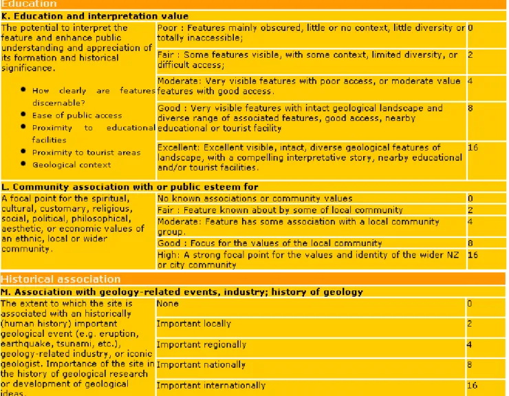
Table IV: Criteria and grading scheme developed for use in Auckland District Scheme for objective scoring the values of earth science heritage sites (including fossil localities). A total score of 40+ is required for a site to be scheduled for protection in the District Scheme.
Although the Inventory includes statements of scientific significance and description, there is insufficient information and the assessments of value are of variable quality and lack sufficient objective rigour to be used on their own to defend the protective scheduling of a site before an Environment Court judge. Because of this, New Zealand's most populous and proactive local authority, Auckland City, contracted the author and the late Les Kermode to develop a more objective scoring scheme to identify "outstanding natural features" in earth science, that would be credible and defendable in a court of law. The design of the scheme was required to be modelled on that already in use for historic buildings and archaeological sites.
Assessing geological values
Auckland City Council has developed the following scheme for scoring the heritage values of earth science sites. Landforms and geological sites of known heritage value are identified from the Geopreservation Inventory, the scien-tific literature and additional field surveys. Thirteen criteria are then used to score the values (Table IV) of each identified site. Foreach site, the scores for the criteria are summed and a cut-off point of at least 40 points must be attained before a site is considered to be of sufficient heritage value for scheduling in the District Scheme.
GEOLOGICAL VALUES
Given most weight are the geological or scientific values of a site. The first criterion is the geological significance of the site, which addresses the question: "How important is the feature to the understanding of the geology or biotic evolution of NZ or the Earth?" Scored highest are sites that are of international significance, followed by national, regional, district-wide, or just significant for under-standing the local geology. The second criterion is the rarity of the site type. It addresses the question of whether this type of site is rare internationally, nationally, regionally etc. Stratotypes of New Zealand biostratigraphic stages or type localities of fossils are scored only under scientific value, as all of these are otherwise unique. A standard method of scoring these has been devised with type localities for international stratotypes scoring the maximum,
followed by New Zealand stratotypes, then type localities of macrofossil species and finally microfossil type localities.
Three additional criteria in this section provide lower value scores. These are scientific potential, representativeness and diversity. Scientific potential addresses the question: "How much potential is there to expand information and understanding of this site through scientific techniques?" Represen-tativeness assesses the "extent to which an exposure is a good example of the type of fossil site", and diversity assesses how many site types or components are present (e.g. macrofossils, trace fossils, cross-bedding, un-conformity, etc.).
CONTEXT AND INTEGRITY
The first criterion in the context section assesses whether the site is a component of a larger group of associated features, what is the significance of the group, and what contribution does the site make to the group. Groups of features might include a cluster of fossil sites that together span the Jurassic in a particular region or collectively include the range of trace fossils found in a widespread formation. The second criterion in the context section assesses the visual contribution of the feature to the wider landscape.
Three criteria are used in the integrity section. The first evaluates whether the feature is located and surrounded by its original setting, and if not whether it can be restored. The other two criteria are used to deduct points from a sites score depending upon the extent of past
loss, if the intrinsic attributes of the feature have been damaged by nature or humans, and an assessment of how permanent a feature is likely to be, given natural weathering and ero-sional processes.
EDUCATION AND HISTORICAL ASSOCIATION
The first criterion in the education section looks at the potential to interpret the feature and enhance public understanding and appreciation of its fossil significance. The assessment process includes how clearly displayed are the features, the ease of public access, proximity to educational facilities, or tourist areas, and the geological context. The second criterion here assesses the community association or esteem for the site or feature. The historic association section has a single criterion, which assesses the site or feature's association with geology-related events (e.g. eruption, tsunami, flood), geology-related industries (e.g. early stone quarry) or the history of geological studies (or association with an iconic geologist).
PROTECTING DIFFERENT TYPES OF FEATURES
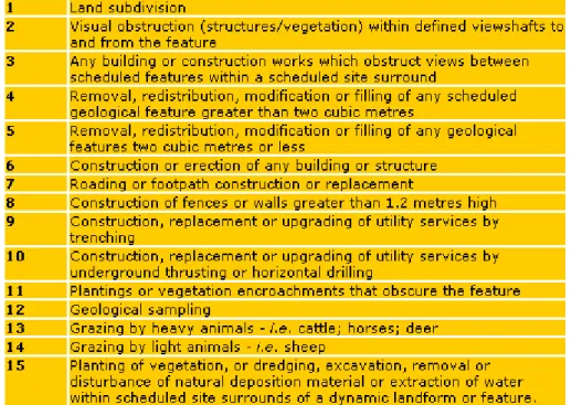
The Auckland City scheme has been developed to recognise also that earth science sites are highly variable and that different types require different levels of protection and diffe-rent types of management. Thus all scheduled sites are placed in one of six feature types (Table V). Fossil sites could be categorised in any of four of these – smaller, more fragile features; exposures of geological materials; fragile exposures; or caves.
Table V: Feature type categories developed for use in Auckland District Scheme for determining which activities are permitted, discretionary or prohibited.
A matrix has been constructed which identifies what proposed activities (Table VI) on a scheduled site are permitted, discretionary (require a council decision based on predicted impact) or prohibited, dependent upon its feature category. For fossil sites the range of proposed activities include: subdivision, excavation, construction of buildings, roads,
footpaths or fences, plantings or vegetation encroachment, grazing, geological sampling.
Thus for a fragile fossil forest all the above activities would be prohibited, except geological sampling by permit only and perhaps construction of a footpath judiciously sited to avoid damage. For a large, robust, rapidly
eroding fossil site in a stream bed, grazing and geological sampling might be permitted without a permit, and all other activities could be dis-cretionary.
Case studies
TITAHI BAY FOSSIL FORESTTitahi Bay is a suburban beach on the west coast of Wellington City. Protruding from the intertidal sand in the middle of the beach are the fossil remains of a Last Interglacial fossil
forest. Some local residents use the beach for launching small boats with trailers towed by motorised vehicles. These sometimes damage the fossil forest and sometimes the boaties remove forest obstacles from the launching area. In the 1990s other members of the local community began complaining that vehicles on the beach were a safety hazard for their families while sunbathing or playing on the beach. The fossil forest was listed in the Geopreservation Inventory and subsequently scheduled on the draft Wellington Regional Coastal Plan.
Table VI: List of activities that are classified as permitted, discretionary or prohibited on scheduled earth science sites dependent upon the feature type category.
In the 1996 the complaining group of locals asked the Wellington Regional Council to ban cars from the beach to more fully implement protection of the fossil forest. At the planning hearing, a Geological Society of New Zealand representative provided an objective assess-ment of the values of the fossil forest (CAMPBELL, 1996, 1997) and eventually after a long battle, vehicles were banned from that part of the beach where the best examples of the fossil forest occur.
TAKAPUNA FOSSIL FOREST
Takapuna is a suburban beach on Auckland's North Shore. Reefs and low cliffs of late Pleistocene basalt lava flow occur at the north end of the beach. Within these flows are preserved the moulds of the lower trunks of in situ trees (Fig. 8) and the higher trunks and branches of trees that had collapsed into some flows and had been rafted along. In the early 1970s, prior to the RMA, a carpark was built over half the northern reef destroying a large area of fossil forest.
Figure 8: Takapuna fossil forest comprises moulds of over 200 tree stumps preserved by the molten basalt lava that flowed around them. The site now has planning protection through its scheduling as an outstanding natural feature on the District Scheme.
Following enactment of the RMA, the remaining parts of Takapuna fossil forest have been scheduled for protection in the North Shore District Scheme. This coast is subject to periodic storm waves that undermine parts of the low lava flow cliffs and large blocks of basalt sometimes fall out. Unfortunately a main sewer pipe runs along the top of this low cliff and the erosion could cause a breach in the
sewer line with disastrous pollution potential. Rather than construct a completely artificial erosion protection wall across the face of the tree-mould-bearing lava flow, the local council opted for the heritage geologist's suggestion for a lower impact method of grouting beneath and between the blocks with colour-matched dark grey concrete. Thus the goals of protecting both the sewer and the fossil forest have been achieved.
ST KENTIGERN'S COLLEGE CLIFFS PEAT SECTION
St Kentigern's college is built on the banks of the Tamaki Estuary in Auckland city. In an 8 m-high cliff on the edge of the school grounds is the best exposure in the region of a 1 myr old section of interbedded peat and distal ignim-brite deposits. Fossil pollen in the peat provide an unparalleled insight into the vegetation of this part of New Zealand during several glacial/interglacial cycles at the start of the mid-Pleistocene Climate Transition.
For many years the local council has been in negotiations with St Kentigerns College trying to persuade them to allow a public walkway, planned for the length of the Tamaki Estuary, to be sited along the top of the cliff on their land. Eventually a compromise was reached with the council planning to construct a 2 m-wide and 2 m-high path at high tide level along the base of the cliff. The college would contribute to the cost as the mud-crete path would also serve as an erosion protection barrier for their land.
Figure 9: Coastal path and wooden bridge specially constructed at the base of the St Kentigern College cliffs to provide for continued erosion and viewing of the early Pleistocene sequence of peat and distal ignimbrite.
Fortunately the peat section was already scheduled on the District Scheme, which specified that consultation with the Geological Society of New Zealand was a pre-requisite to the granting of any permits to undertake work in the vicinity of scheduled sites. The geologists pointed out that the proposed path would spell the end of the peat-ignimbrite exposure, as without continued erosion at the base it would quickly weather to clay and become covered in vegetation. The Geological Society suggested that a 10 m-long wooden bridge be constructed across the front of the best stratigraphic
exposure to allow continued erosion of one part of the cliff (Fig. 9). Permits were granted and the pathway and bridge were constructed in 2006. The path now provides ready viewing access to the section which the college and the public can now use for educational purposes.
CORMACK'S SIDING DIATOM TYPE LOCALITY
Cormack's Siding was a low cutting and earth platform used for loading stock onto a now-disused railway line in North Otago. The locality was right next to a main road and the cutting provided a readily accessible source of fresh late Eocene Oamaru Diatomite (EDWARDS, 1991). In the heydays of amateur diatomists in the late 19th century many samples of diatomite from this locality were sent around the world as exchange samples. As a result Cormack's Siding became the type locality for over 13 species of archaeomonads and 108 species of diatom (EDWARDS, 1991), and was therefore a site of international importance.
The site was not regularly visited by geologists, and unfortunately before it could be added to the local District Scheme schedule it was bulldozed away and completely destroyed during road widening in 2000.
VANISHED WORLD TOURIST TRAIL
The Oamaru district in North Otago is well-known for its richly fossiliferous marine sedimentary strata, mostly of Eocene, Oligocene and Miocene age, but also including some Cretaceous concretions (Fig. 10) con-taining near-complete skeletons of marine Reptiles (e.g. CRUICKSHANK & FORDYCE, 2002). Several localities have been the source of some unique whale bones and partial skeletons and the fossil bones of some of the largest-ever recorded penguins (2 m tall; FORDYCE & JONES, 1990).
In the early 2000s, a group of geologically-literate local citizens saw an opportunity to promote tourism in the Oamaru area. They teamed up with Otago University-based verte-brate paleontology specialist Ewan FORDYCE to produce a pamphlet and road guide to the best and most easily accessible fossil sites in the district (FORDYCE, 2002). A visitor centre with educational displays of fossils has been opened at Duntroon (URL:
http://www.vanishedworld.co.nz/index.htm). The pamphlet outlines a self-drive tour around a mixture of public and privately-owned fossil and other geological sites that tell the geological history of the Oamaru area. Ewan realised that the raised public profile of these sites would increase their educational value and increase the appreciation by a number of landowners of the valued fossil sites they owned and should care for.
Figure 10: Large plesiosaur-bearing concretions such as this at Shag Pt, are part of the Vanished World Fossil Trail, which through public education is helping to protect the fossil heritage of the Oamaru district.
This innovative concept is a first for New Zealand, linking education and protection of fossil sites in a way not dissimilar to the Geo-Parks programme in some countries elsewhere.
The future
In New Zealand we already have many categories of reserve, covenant and planning, well-suited our more important fossil sites. I see no need for the introduction of a new category, such as GeoParks. Indeed, the New Zealand public are already somewhat perplexed and find it difficult to understand the differences between the existing categories of reserve, and thus it would be difficult to persuade decision-makers that yet another category was needed.
In the last 20 years there has been a significant decline in the gazettal of formal reserves to specifically protect earth science features and fossil sites in New Zealand. This undoubtedly reflects the increasing costs of public purchase of private land to achieve such status. In the foreseeable future the goals of earth science conservation, including fossil sites, are likely to be best achieved by a combination of increased use of covenants over private land and implementation of a more rigorous and objective methodology for the scheduling of an increasing number of fossil and other earth science sites on district schemes. Both these instruments do not require the enormous expense of land purchase and rely on the education of the land owners so that they will recognise and cherish the fossil treasures they are guardians of.
The downsides to the use of the RMA are: 1. that a lower level of protection to that of
reservation or covenanting is achieved; 2. protection relies in part on the
decision-making of elected local politicians, the vagaries of local body politicians, and the recommendations of local authority planning staff;
3. this method requires continued vigilance on behalf of earth science
conser-vationists to ensure that local authorities are carrying through the excellent policies of the RMA and not ignoring earth science conservation, forever the poor cousin of biotic conservation.
To achieve our earth science conservation goals will require continual education of local body planners as to the equal value and needs of this aspect of conservation.
Acknowledgements
I thank Hamish CAMPBELL, Ewan FORDYCE, Hugh GRENFELL and Jere LIPPS for reading the manuscript and suggesting improvements
Bibliographic references
CAMPBELL H.J. (1996).- Titahi Bay fossil forestfloor.- Geological Society of New Zealand, Newsletter, Auckland, n° 110, p. 22-24. CAMPBELL H.J. (1997).- Wellington fossil
loca-lities. Geological Society of New Zealand Annual Conference Field Trip Guide FT 1.- Geological Society of New Zealand, Miscellaneous Publication Series, Auckland, MP95B, p. 1-17.
COOPER R.A. (ed., 2004).- The New Zealand geological timescale.- Institute of Geological and Nuclear Sciences, Monograph, Lower Hutt, n° 22, 284 p.
CRUICKSHANK A.R.I. & FORDYCE R.E. (2002).- A new marine reptile (Sauropterygia) from New Zealand: further evidence for a Late Cretaceous Austral radiation of cryptoclidid plesiosaurs.- Palaeontology, London, vol. 45, n° 3, p. 557-575.
EDWARDS A.R. (1991).- The Oamaru Diatomite.-
New Zealand Geological Survey, Paleon-tological Bulletin, Wellington, n° 64, 260 p. FINLAY H.J. & MARWICK J. (1947).- New divisions
of the New Zealand Upper Cretaceous and Tertiary.- New Zealand Journal of Science and Technology, Wellington, (B, General research section), vol. 28, p. 228-236.
FLEMING C.A. (1979).- The Geological history of New Zealand and its life.- Auckland University Press, Auckland, 141 p.
FORDYCE R.E. (2002).- Vanished world fossil trail, North Otago, New Zealand.- Vanished World Inc., Duntroon, pamphlet.
FORDYCE R.E. & JONES C.M. (1990).- The history of penguins, and new fossil penguin material from New Zealand. In: DAVIS L.S. & DARBY J.D. (eds.), Penguin biology.- Academic Press, San Diego, p. 419-446
HAYWARD B.W. (1988).- Clifden Scientific Reserve, Southland.- Geological Society of New Zealand, Newsletter, Auckland, n° 80, p. 16-21.
HAYWARD B.W. (1990).- Trilobites, dinosaurs and moa bones. The story of New Zealand fossils.- Bush Press, Auckland, 104 p.
HAYWARD B.W. & WARD B. (1987, unpublished).- Inventory of New Zealand fossil localities of international, national and regional impor-tance.- Geological Society of New Zealand,
Auckland, Unpublished Report 87/1, 106 p. HORNIBROOK N. de B. (1990).- Hutchinsons
Quarry and Target Gully shell pit geological reserves, Oamaru.- Geological Society of New Zealand, Newsletter, Auckland, n° 89, p. 46-49.
KEYES I.W. (1984).- Joan WIFFEN and the Mangahouanga Stream reptiles: a profile.- Geological Society of New Zealand, News-letter, Auckland, n° 63, p. 29-32.
LEWIS D.W. (1984).- Chancet Rock Scientific Reserve.- Geological Society of New
Zea-land, Newsletter, AuckZea-land, n° 66, p. 61-63. POLE M. (1990).- The Curio Bay Scientific
Reserve.- Geological Society of New Zealand, Newsletter, Auckland, n° 89, p. 34-37.
WEAVER S.D. & HAYWARD B.W. (1983).- An inventory and assessment of New Zealand geological and geomorphological features of national and regional importance.- Geological Society of New Zealand, News-letter, Auckland, n° 59, p. 22-24.