HAL Id: hal-00297401
https://hal.archives-ouvertes.fr/hal-00297401
Submitted on 28 Jun 2007
HAL is a multi-disciplinary open access
archive for the deposit and dissemination of
sci-entific research documents, whether they are
pub-lished or not. The documents may come from
teaching and research institutions in France or
abroad, or from public or private research centers.
L’archive ouverte pluridisciplinaire HAL, est
destinée au dépôt et à la diffusion de documents
scientifiques de niveau recherche, publiés ou non,
émanant des établissements d’enseignement et de
recherche français ou étrangers, des laboratoires
publics ou privés.
Atmospheric patterns for heavy rain events in the
Balearic Islands
A. Lana, J. Campins, A. Genovés, A. Jansü
To cite this version:
A. Lana, J. Campins, A. Genovés, A. Jansü. Atmospheric patterns for heavy rain events in the Balearic
Islands. Advances in Geosciences, European Geosciences Union, 2007, 12, pp.27-32. �hal-00297401�
www.adv-geosci.net/12/27/2007/ © Author(s) 2007. This work is licensed under a Creative Commons License.
Geosciences
Atmospheric patterns for heavy rain events in the Balearic Islands
A. Lana, J. Campins, A. Genov´es, and A. Jans`a
Centre Meteorol`ogic de les Illes Balears, Instituto Nacional de Meteorolog´ıa, Spain
Received: 27 February 2007 – Revised: 18 April 2007 – Accepted: 13 May 2007 – Published: 28 June 2007
Abstract. The Balearic Islands, as well as other
Mediter-ranean regions, are occasionally affected by heavy rain events, which can produce numerous damages. This study contributes to improve the understanding of the dynamical mechanisms that produce heavy rain events by means of a classification of their related atmospheric patterns.
Heavy rainfall dataset for the Balearic Islands and some gridded atmospheric parameters, derived from the HIRLAM-INM-0.5◦analyses, were the data used in this study. Heavy rain events were recorded at a set of pluviometric stations along the Balearics for a period of 9 years, from June 1995 to May 2004. The 1000 hPa and 500 hPa geopotential heights (hereafter φ1000and φ500), as well as the 850 hPa temperature
(T850) were the fields utilized in the classification.
By means of a principal components analysis (PCA) the number of variables was reduced. The cluster analysis (CA) was then applied on those new variables and eight atmo-spheric patterns were finally obtained. Most of the patterns showed a strong relationship between heavy rain events and cyclones.
1 Introduction
The Western Mediterranean countries are affected by episodic severe weather phenomena, like heavy rain events (HR, hereafter), that usually produce numerous damages and, consequently, a strong economical and social impact in the area.
In the particular case of the Balearic Islands, the presence of a cyclone related to the heavy rain events has been ob-served in previous works by different authors, like Campins et al. (2006a), Jans`a et al. (2000) and Romero et al. (1999), and it is on the basis of the MEDEX project. The MEDEX
Correspondence to: A. Lana
project has the objective of improving the knowledge and the forecasting of the cyclones that produce high impact in the Mediterranean weather, focusing especially on heavy rains and strong winds (see http://medex.inm.uib.es).
The present study is an attempt to improve the understand-ing of the dynamical mechanisms that produce these phe-nomena, from a statistical point of view. The objective is to obtain the atmospheric patterns (hereafter, AP) that pro-duce heavy rain events in the Balearic Islands. Some previ-ous studies that analysed the synoptic atmospheric patterns related to extreme precipitation in other Mediterranean areas can be found in Houssos and Bartzokas (2006) and Romero et al. (1999).
2 Data and methodology
According to the data included in the MEDEX database and for the purpose of this study, a heavy rain event is defined as one that produces at least 60 mm of rain in 24 h, at least in one pluviometric station. This threshold is similar to that used in other previous works (Jans`a et al., 2001).
This study is a continuation of that of Campins et al. (2006a) whose main objective was to demonstrate the rela-tionship between heavy rain and strong wind events in the Balearics and the presence of a cyclone in the area. As it is explained in Campins et al. (2006a), the rainfall data used in this study were registered between June 1995 and May 2004 at 216 pluviometric stations placed at the Balearics. 157 events of heavy rain were registered throughout these 9 years. This implies an average of 17.4 events per year (see Table 1 from Campins et al., 2006a), in which 8.6 events were noted in autumn (≈50%). In 135 events of the 157 HR events (≈87%) a cyclone center was detected within a radius of 600 km around the Islands. Furthermore, the location of the cyclone center allowed the feeding of warm air to the HR affected area (for further details see Campins et al., 2006a).
28 A. Lana et al.: Atmospheric patterns for heavy rain events
Table 1. Number of HR events per season for each AP and for the
total set of events.
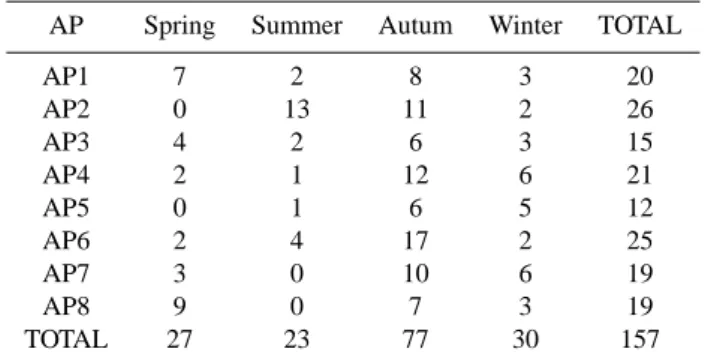
AP Spring Summer Autum Winter TOTAL
AP1 7 2 8 3 20 AP2 0 13 11 2 26 AP3 4 2 6 3 15 AP4 2 1 12 6 21 AP5 0 1 6 5 12 AP6 2 4 17 2 25 AP7 3 0 10 6 19 AP8 9 0 7 3 19 TOTAL 27 23 77 30 157
In order to obtain the atmospheric patterns, smoothed grid-ded data from the High Resolution Limited Area Model from the Instituto Nacional de Meteorolog´ıa, with a 0.5◦
latitude-longitude resolution (HIRLAM-INM-0.5◦), were used. The
study area comprised the domain from 33.5◦N to 45.5◦N,
and from 6◦W to 11◦E. This placed the Balearics at the cen-ter of the study area, and took into account a great part of the Western Mediterranean Sea that affects the meteorolog-ical conditions of the islands, as the Gulf of Genoa and the coast that surrounds the islands.
For each HR event, the value of φ1000, φ500 and T850 at
the 875 grid points belonging to the area described above, were considered to be relevant in the heavy rain generation. HIRLAM-INM-0.5◦ analyses are available four times in a day (at 00:00, 06:00, 12:00 and 18:00 UTC), whereas rainfall data matched for a 24 h period, between 07:00 UTC of day D and 07:00 UTC of day D+1. In order to consider a correspon-dence between rain events and analysed fields, the analysis with the closest cyclone center to the Balearics (within a ra-dius of 600 km) was selected (Campins et al., 2006a). If any cyclone was located a distance higher than 600 km, or even if no cyclone was detected, 12:00 UTC was selected as the representative for the 24 h interval.
Atmospheric patterns related to HR events were derived by using PCA and CA (Yarnal, 1993). First of all, the T-mode (day-by-day) correlation matrix was subjected to PCA for each parameter. Only the most important extracted com-ponents were considered, that is, by accounting at least the 90% of the total variance. Thus, 6 components were stored for geopotential at 1000 and for the temperature at 850 hPa and 4 components for geopotential at 500 hPa. After that, the CA was applied to the total matrix of loadings (with 16 load-ings) of the 157 events. The CA classifies objects (days in this case) in groups, whose elements are similar (in the sense of the PC loadings). In other words, days with similar load-ings on the extracted components were clustered together. The clustering algorithm was the non-hierarchical k-means method (Anderberg, 1973). This algorithm minimizes the
total (or sum of) intra group sum of squares (W ), and W de-creases as the number of groups (k) inde-creases. In this method the number of groups needs to be indentified before the al-gorithm proceeds. The optimal number of groups was se-lected when the decrease was not significant. In the present study the decrease of W respect to k was calculated for k=2 to k=20. Furthermore, to explore the possible number of groups, tree diagrams, obtained from hierarchical methods, were also examined.
3 Results
3.1 HR Atmospheric Patterns
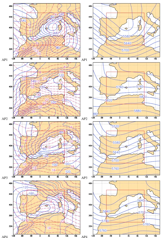
Eight AP were obtained (hereafter AP1, AP2,...AP8). For each one, mean fields were obtained for parameters at differ-ent levels by averaging all the gridded analysis for the mem-bers of that AP. The following description is mainly based on the atmospheric fields, φ1000, φ500and T850, used to obtain
the patterns (see Fig. 1). Furthermore, in order to deepen into the description of the AP, other fields as 850 hPa geopoten-tial height and the relative humidity at 925 hPa and 850 hPa, were also considered (not shown here).
An aspect that must be taken into account is that each AP is an average of different atmospheric fields of the days clas-sified in each cluster. Therefore each AP must be analysed bearing in mind that it is not a real atmospheric pattern, but an average of real ones.
AP1 is characterized by an intense low pressure centre close to Balearics at 1000 hPa, and a trough that extends from the Atlantic up to the Balearics at 500 hPa. A frontal wave in thermal and relative humidity fields at 850 hPa is clearly suggested, which could induce a flow of wet and warm air over the islands.
Apart from AP5, the weakest cyclonic structure at 1000 hPa for all of the patterns, is represented by the average of AP2. At 500 hPa a weak trough over West Europe with a zonal flow over the Balearics can be outlined. The thermal field at 850 hPa presents a warm ridge over the Iberian Penin-sula, coinciding with low values of relative humidity. Over the Balearics a strong thermal gradient separates cold air at the North from warm air at the South. Moreover, a maritime low placed at the southwest edge of the Mediterranean that extends inland Spain is observed. This pattern occurs mainly in summer. In this season, the cyclones tend to be over land, concentrated in the Iberian Peninsula and Algeria, and Mo-roccan coast region (Campins et al., 2006b). AP2 is the most frequent of the patterns, with 26 events (≈17% of the total events).
AP3 is characterized at low levels by an extended low pres-sure system that includes the Balearic Islands, the Gulf of Lyon and the Gulf of Genoa. The geopotencial field at up-per levels shows a trough over the Iberian Peninsula, with a southwesterly flow over the Balearics. There is a cold
AP1 AP1
AP2 AP2
AP3 AP3
AP4 AP4
✾
Fig. 1. Left panels: geopotencial at 1000 hPa (blue solid lines, 10 gpm) and temperature at 850 hPa (red dashed lines, 1◦C). Right panels: geopotencial at 500 hPa (blue solid lines, 30 gpm) for AP1, AP2, AP3 and AP4. In solid red box the sudy domain where the classification was performed.
30 A. Lana et al.: Atmospheric patterns for heavy rain events
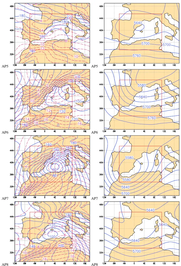
AP5 AP5
AP6 AP6
AP7 AP7
AP8 AP8
Fig. 1. Continued for AP5, AP6, AP7 and AP8.
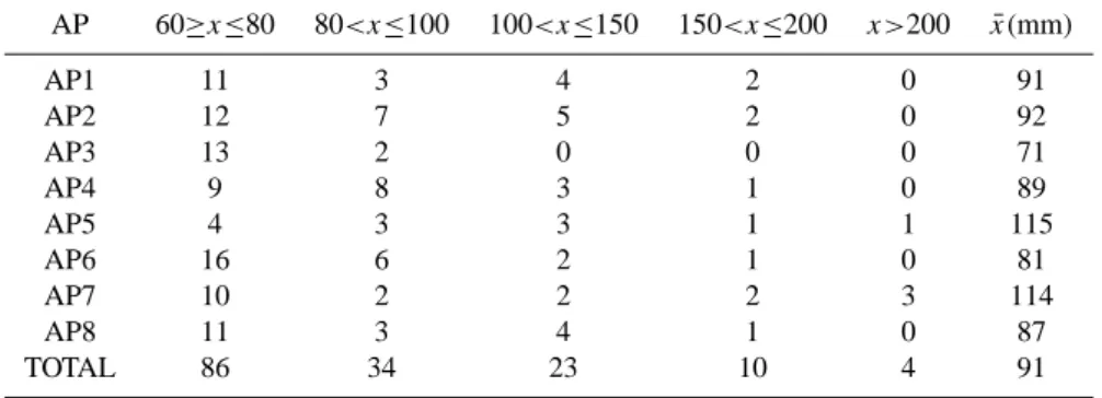
Table 2. Number of HR events for different intervals of maximum rainfall (in mm/24 h) and mean value of maximum rainfall ( ¯x(mm)) for
each AP and for the total set of events.
AP 60≥x≤80 80<x≤100 100<x≤150 150<x≤200 x>200 x(mm)¯ AP1 11 3 4 2 0 91 AP2 12 7 5 2 0 92 AP3 13 2 0 0 0 71 AP4 9 8 3 1 0 89 AP5 4 3 3 1 1 115 AP6 16 6 2 1 0 81 AP7 10 2 2 2 3 114 AP8 11 3 4 1 0 87 TOTAL 86 34 23 10 4 91
advection over Iberian Peninsula and a warm ridge over the islands. This warm air flows over the sea, so a large amount of moisture can contribute to the precipitation feeding.
There is a low pressure center in AP4, right next to the Balearics at low levels. At high levels this pattern is chara-terized by a trough over the Iberian Peninsula that produces southwesterly flow over the Balearics. The temperature dis-tribution exhibits a thermal ridge over the islands, that could bring warm flow to the archipelago from North Africa. At low levels, this pattern presents high values of relative hu-midity over the Balearics and hence the feeding of moisture to produce precipitation is guaranteed.
AP5 is the less frequent pattern, with only 12 events of heavy rain. At low levels, this pattern is characterized by a pressure trough and a warm ridge to the east of the islands. As a result, an easterly warm flow is induced over the sea, accounting for large values of humidity. At 500 hPa, a cut-off low just over the Balearic Islands is observed.
There is a cyclone at low levels in AP6, situated over the Gulf of Genoa, that induces cold advection from the North, reaching the Balearic Islands. At high levels, the presence of a trough that extends from France to the Iberian Peninsula favours the upward motion.
AP7 presents a deep cyclone. At 1000 hPa, the cyclone is situated over the Balearics, it is very intense, and at 500 hPa there is a cut-off situated in the southwest of the Balearics. This situation induces warm and moist air to the islands, as it is shown by the temperature field and the trayectory over the sea, which is an important factor for the generation of heavy rain events.
Pattern AP8 presents a cyclone over the Islands at low levels. At 500 hPa, there is a weak trough that covers the Balearic Islands. The temperature structure indicates no re-markable features, with a weak gradient over the Balearics.
4 Discussion and further remarks
In order to study the relationship between the patterns and the HR events, both the pluviometric histograms and the HR seasonal distribution were obtained for each pattern. Tables 1 and 2 show those distributions.
As Fig. 1 shows, the presence of a cyclone centre near the Balearics is observed in most of the AP. In six of them (AP1, AP3, AP4, AP6, AP7 and AP8) the cyclone is clearly associated with the HR events. Besides the presence of a cy-clone, the 850 hPa temperature field is quite similar for these patterns, with a warm ridge or a frontal structure, that could induce warm air to the islands. However, at 500 hPa there is a wide variety of atmospheric structures. On the one hand, in AP1 and AP8, the trough extends from the Atlantic Ocean up to the Balearics. On the other, the trough extends from the West of Europe, over the Iberian Peninsula in patterns AP3, AP4 and AP6. Finally, AP5 and AP7 show a cut-off at up-per levels. Moreover AP7 is a very rainy one, with a mean maximun precipitation of 114 mm per day, and as it was ex-pected, almost all of the cases of this pattern are in autumn.
In summary, in spite of the differences between patterns, a general scenario for heavy rain in the Balearics can be described: at low levels an intense cyclone drives warm and moist air towards the islands, which ascent is usually favoured at upper-levels.
There are two patterns with a weak cyclone at low levels that deserve special attention: AP2 and AP5.
As mentioned in the previous section, AP2 at 500 hPa presents a zonal flow over the Balearics and a weak trough over the West Europe. When a deeper analysis of some par-ticular cases is performed, a short-wave trough, embeded into the mean flow can be found (which is smoothed in the mean field). This short-wave trough is accompained with a cold air intrusion to the Mediterranean through the gulf of Lyon, which could act as a trigger mechanism. As many of these events are registered in August and first days of September, these condicions are able to produce local convection. In fact, for most of these events HR was recorded in just one point.
32 A. Lana et al.: Atmospheric patterns for heavy rain events
AP5, unlike the other patterns, is not always associated with a cyclone at low levels. However, as Table 2 shows, this pattern is the most rainy one. As it has been mentioned, the low level circulation is characterized by a warm easterly flow that ensures the continous feeding of moist air. In addition, the presence of a cut-off at high levels favours the lifting of the air. These conditions finally contribute to the great effi-ciency of precipitation.
5 Conclusions
Eight atmospheric patterns have been obtained to explain the heavy rain events in the Balearic Islands. In spite of the fact that the patterns do not correspond to real atmospheric con-figurations, being obtained by averaging real fields, most of them reproduce the presence of a cyclonic structure at low levels, close to the rain affected region.
Two main groups can be distinguish according to the in-tensity of such a cyclone. For most of the patterns, the pres-ence of an intense or moderate cyclone at low levels and the configuration at upper levels can consistently explain the oc-currence of rain. Only in two cases (AP2 and AP5) the cy-clone is weak or not clearly present at low levels, although a weak cyclonic circulation is always suggested. AP5, the most rainy atmospheric pattern, presents a cut-off at upper levels, consistent with the presence of heavy rain. The zonal configuration at high levels and the weak cyclonic circula-tion at low levels for AP2 renders the HR mechanism not evident, but the great number of members belonging to this pattern produces a smoothing of small scale features.
The atmospheric patterns could explain the heavy rain events of the Balearic Islands and could be a helpful tool for the improvement of the forecast of these severe weather events.
Acknowledgements. The authors wish to thank M. A. Picornell for
her helpful comments. This work has been partially funded by the CICYT CGL2005-05681/CLI grant.
Edited by: P. Alpert, H. Saaroni, and E. Heifetz Reviewed by: two anonymous referees
References
Anderberg, M. R.: Cluster Analysis for Applications, Academic Press, New York, 1973.
Campins, J., Jans`a , A., and Genov´es, A.: Heavy rain and strong wind events and cyclones in the Balearics, Adv. Geosci., 7, 73– 77, 2006,
http://www.adv-geosci.net/7/73/2006/.
Campins, J., Jans`a, A., and Genov´es, A.: Three-dimensional struc-ture of Western Mediterranean cyclones, Int. J. Climatol., 26, 323–343, 2006.
Houssos, E. and Bartzokas, A.: Extreme precipitation events in NW Greece, Adv. Geosci., 7, 91–96, 2006,
http://www.adv-geosci.net/7/91/2006/.
Jans`a, A., Genov´es, A., and Garc´ıa-Moya, J. A.: Western Mediter-ranean cyclones and heavy rain. Part I: Numerical experiment concerning the Piedmont flood case, Meteorol. Appl., 7, 323– 333, 2000.
Jans`a, A., Genov´es, A., Picornell, M. A., Campins, J., Riosalido, R., and Carretero, O.: Western Mediterranean cyclones and heavy rain. Part II: Statistical approach, Meteorol. Appl., 8, 43–56, 2001.
Romero, R., Sumner, G., Ramis, C., and Genov´es, A.: A classica-tion fo the atmospheric circulaclassica-tion patterns producing significant daily rainfall in the Spanish Mediterranean area, Int. J. Climatol., 19, 765–785, 1999.
Yarnal, B.: Synoptic Climatology in Environmental Analysis, Bel-haven Press, London, 1993.