by Bachelor of Architecture
Anubhav Gupta TVB School of Habitat Studies
New Delhi, India. (2001) Submitted to the Department of Urban Studies and Planning I Department of Architecture
in partial fulfillment of the requirements for the degrees of Master in City Planning I Master of Science in Architecture Studies
at the
MASSACHUSETTS INSTITUTE OF TECHNOLOGY June 2005
© 2005 Anublav Gupta. All Rights Reserved
J. 1
.-Author
Anubhav Gupta Deparfment of Architecture Urban Studies and Planning
May 12, 2005
Certified by
fA f5di d i
Certified by
Professor Julian Beinart
Accepted by
Professor Dennis Frenchman
Accepted by
Professor Julian Beinart
MASSACHUSETTS INS E OF TECHNOLOGY
JUN 2 8 2005
LIBRA
R1ES
ROTCH
Professor o Urban Stu es an anning Thesis Supervisor
'T9
Professor of Architecture Thesis Supervisor'hair, MCP Committee, Department of Urban Studies and Planning
I
\-) Professor of Architecture Chairman, Departmental Committee for Graduate Studentsthe c
hofhrby gets to MiT
pem
o to eprod e d to
tMe pubicy paper and
ele-onic copies of ths theis
doCanent I whoe
or In nrtProuessor Lawrence J. v ale
The author hereby grants to MIT permission to reproduce and to distribute publicly, paper and electronic copies of this thesis document in whole or in part.
THESIS COMMITTEE
Lawrence J. Vale Department Head and Professor of Urban Studies and Planning Department of Urban Studies and Planning, MIT Julian Beinart Professor of Architecture Chairman, Departmental Committee for Graduate Students Department of Architecture, MIT Michael Dennis Professor of Architecture Department of Architecture, MIT
Thesis Supervisors
Thesis Reader
DOMINION GEOMETRIES: Colonial construction & Postcolonialpersistence of the Imperial in the New Delhi Plan
by
Anubhav Gupta
Submitted to the Department of Urban Studies and Planning Department of Architecture On May 12, 2005 in partial fulfillment of the requirements for the degrees of
Master in City Planning | Master of Science in Architecture Studies Abstract
New Delhi is not only the capital of India but the capital of the world's largest democracy. Conceived and built by the British, the New Delhi plan translated British India's home policy in sandstone. The government's administrative hierarchy and centralization of power was directly represented in the physical plan that impressed its magnificence and power over a country awakening to freedom. A realized grand vision imperial plan in an ideologically contradictory circumstance of independence and democracy is the unique departure point for this work. Divided in two parts corresponding to the colonial and postcolonial timeframes, this thesis attempts to answer the central questions of:
e How was the Imperial constructed in colonial Delhi?
* How and why has it persisted in the postcolonial evolution of New Delhi?
At the macro level, this research engages intersecting themes of political ideology, physical planning, policy, culture and evolution in contemporary city form. The motivation for this research emerges from my own subscription to the fact that "[New Delhi today is] a kind of an overgrown capitol complex, resolutely detached from the rest of the city."' In my view, it is the persistence or resistance of the "Imperial" in the post colonial democratization of New Delhi that is largely responsible for the fractures in the city's identity, urban form, sustenance and evolution.
Thesis Supervisors Title
Prof. Lawrence
J.
Vale Professor of Urban Studies and Planning, Department Head, DUSP, MIT Prof. Julian Beinart Professor of Architecture, Chairman, Departmental Committee forGraduate Students, MIT
ACKNOWLEDGEMENTS
,- was born and raised till the age of three in New Delhi. After a hiatus of nearly thirteen years, I returned to my home city to go to architecture school. It is here that I really came to respect and appreciate the rich history, architecture and cultural legacy of my great city. However, I simultaneously longed to understand the reason behind certain disconnects, fractures and general inequity that is explicit in the fabric of the city today. Three enriching years of my education at MIT has provided me the tools and intellect necessary to frame my questions in order to understand the city. Through this thesis, not only have I been able to examine the issues plaguing New Delhi, but in the process I have developed a personal appreciation for the complex roots that have caused such cleavages in its urban fabric. Although it is true that this journey has tempered my optimism (as a citizen) greatly, I will always carry a glimmer of hope (as an architect and urban designer/planner) that a better, more livable, equitable and sustainable city will rise giving its citizens the much needed pride that they deserve.
This Master's thesis would not be in the form today without the patience, guidance, knowledge and direction of my thesis advisors at MIT, Prof. Lawrence
J.
Vale and Prof. Julian Beinart. I have tremendously benefited from our discussions and your critical comments on my work. I would also like to thank Prof. Michael Dennis (thesis reader), Prof. Dennis Frenchman (academic advisor) and Greg Morrow for their friendship, interest and continuous support during my tenure at MIT. My sincerest gratitude goes to Prof. Mark J. Schuster and my colleagues in his wonderful thesis prep class who prompted me to think seriously about my thesis topic and frame the right research questions.I also wish to thank the numerous departments/people/organizations that have generously provided for my invaluable source of funding over the past three years:
Department of Architecture, MIT
Department of Urban Studies and Planning, MIT
Kenneth Kruckemeyer - Department of Transportation and Logistics, MIT
Prof. William Porter - Department of Architecture, MIT
ACKNOWLEDGEMENTS
Prafulla Mukerji Scholarship Fund, New
Jersey
G.D. Goenka Scholarship, IndiaFinally, I would like to thank my parents and my sister for their unconditional love and support in seeing me through my academic, professional and personal pursuits over twenty seven years of my existence. Last but not least, none of this would have been possible without the unconditional love, patience, support and companionship of my wife Aditi Mitra. She not only revised my various drafts to make the final product what it is, but also constantly engaged and challenged me to broaden my intellectual perspective. Apart from being my second set of eyes into the world, her knowledge and kindness never cease to amaze me and for that I am eternally grateful.
Unless otherwise mentioned, all views and conclusions in this thesis are entirely my own.
-DOMINION
GEOMETRIES
ColSIIAL CIMSTEIChSI
ANR
P114'C91NIAL PER3S TENCE IF TIE IMPEIAL
IN' TBE
EW
LI
PLAN
O"
li K ii II ill/7
F
k
9
~iI 4I.
Ii
I II
DOMINION GEO
COLONIAL CONSTRUCTION ANl
METRIES
PBSTCSLSNIAL PERSISTENCE OF
TIE IMPERIAL IN TIE NEW BELMI PLAN
ANUBHAV GUPTA
To my Parents
You are to me what evey parent hopes to be to their child. Thank You!
To the Citizens of New Delhi
Who patiently await its regeneration as a truly democratic capital city of India.
Plan of New Delhi, Canopy of George V Sources: Andreas Volwahsen, Imperial Delhi
Robert Grant Irving, Indian Summer Plan of New Delhi, Canopy of George V Sources: Andreas Volwahsen, Imperial Delhi
Robert Grant Irving, Indian Summer DEDICATION
Freut
livar
INTRODUCTION
1.1 On Delhi ...- 17
1.2 On Colonial and Imperial ... 21
1.3 On Imperialism ... 23
1.4 On Urban Artifacts ... 27
1.5 On Persistence of the Imperial ... 29
PROLOGUE
2.1 Delhi of Whores and Lovers ... 332.2 The Ghosts of Delhi ... 34
COLONIAL PERIOD
3.1 British in India/Delhi ... 373.2 Shifting the Capital ... 39
3.3 Setting the Stage .... 41 3.3.1 Patrons
3.3.2 Designers
CONTENTS
3.3.2.2 Herbert Baker 3.3.2.3 H.V. Lanchester
3.4 Imperial Planning Process ... 49
3.4.1 Site Selection
3.4.2 Evolution of City Plan 3.4.2.1 Stages
3.4.3 Sanctioned Plan 3.4.3.1 Geometry
3.4.4 Models of Inspiration (Precedents) 3.4.4.1 Paris
3.4.4.2 London
3.4.4.3 Washington D.C. 3.4.4.4 Canberra
3.5 Imperial Designs: Indian Realities ... 65 3.5.1 Separation, Land use and Zoning
3.5.2 Duplicitous Imperialism 3.5.2.1 Plan
3.5.2.2 Landscape
3.5.2.3 Buildings
3.5.3 Realized Master Plan in a Confused Circumstance
3.6 Conclusion - How the Imperial had been Constructed ... 81
POSTCOLONIAL PERIOD
4.1 Partition, Independence and Democracy ... 87
4.2 Transfer of Capital ... 91
4.3 Setting the Stage
4.3.1 Patrons: Gandhi, Nehru
4.3.2 Committees, Agencies and Master Plans 4.4 Indian 4.4.1
4.4.2
4.4.3 4.5 Indian 4.5.14.5.2
Planning Process DemocratizationMaster plans and Development Preservation
Designs: Imperial Realities
Separation, Land use, Zoning, Symbol Institutional Persistence of the Imperial 4.6 Conclusion - How the Imperial has Persisted
A,
J
AFTERWORD
5.1 Final Remarks
5.2 New Developments, Future research, Recommendations
h
SELECTED BIBLIOGRAPHY
ILLUSTRATION CREDITS
... 95 ... 105 ...119
...
129 ... 133 ...135
...
141
...
151
INTRODUCTION
1.1
ON DELHI
New Delhi, the capital of India represents a palimpsest of over 3,500 years of history and splendor witnessed in the remains of many cities built, abandoned, plundered, renovated and rebuilt over succeeding waves of time. Its persistence and continuous existence has lived through nearly four centuries of documented urban planning since Shahjahan's old Delhi
(1638) through Lutyens' New Delhi (1912) and the continuing Master Planned Delhi (1957 Fig. 1 Valled City of Shahjahanabad onwards). In the past, this strong tradition of planning has often been informed or
perpetuated by events of political upheaval. These include the Mughal occupation of India (pre-nineteenth century), the East India Company defeating the Mughals in 1803 to take over Delhi, shifting of British India's capital from Calcutta to New Delhi (1911) and finally the partition & independence of the country in August, 1947.
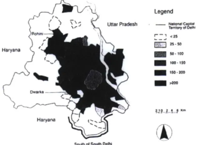
Today the National Capital Territory of Delhi occupies an area of 1486 sq. km., housing a population of nearly 13.8 million people2. In comparison, when conceived by the British, New Delhi was to cover an area of 13 sq. km. for a projected population of 65,000 people.
2 From: http://www.econommatch.com/stateprofies/deU/rofile.htm Date Accessed: April 11, 2005.
3 Singh, Patwant and Dhamija, Ram. (eds.) Delhi: The Deepening Urban Crisis. (Delhi: Sterling Publishers Pvt. Ltd., Fig. 2 British P/anmed New Delhi
INTRODUCTION
Fig. 3 Briish Planned New Delhi
Fig. 4 Alaster Planned New Delhi
Fig. 5 National Capital Region
At this time in 1911, the population of Delhi was about 400,0004 which rose to 636,000' (in the rest of Delhi and the new planned city which spread over an area of 170 sq. km.) in 1931 after the completion of the capital. The advent of Indian independence and partition saw an exodus of nearly 500,000 refugees from Pakistan to Delhi between 1947 and 1950.6 Over the following years, New Delhi assumed the significance of a capital as well as a central employment center for North India continuing to attract numerous migrants from the rest
of the country. Today, a National Capital Region (NCR) covering 30,000 sq. km. has been
delineated to manage its growth while the city continues to sprawl outward attracting a and population explosion is the persistence of a 'garden city' suburb with low densities in the heart of the city (British planned New Delhi). The lack of public infrastructure and growth management strategies, rising land values, unemployment and a dysfunctional planning mechanism have further caused visible fractures between the center and rest of the city.
Whether there is a disconnect between the planning process and existing ground realities or
simply the lack of socio-political will that drove strong traditions of urban planning in the
4 Ibid., 17.
5Jain, A.K. The Making of a Metropolis.: Planning and Growth of Delhi. (New Delhi: National Book
Organization, 1990): 73.
6 Singh, B.P. and Varma, Pavan K. (eds.) The Millennium Book on New Delhi. (New Delhi: Oxford University
Press, 2001): 56 (caption).
simply the lack of socio-political will that drove strong traditions of urban planning in the past, "[New Delhi today is] a kind of an overgrown capitol complex, resolutely detached
from the rest of the city."7 For many reasons (as discussed below), this thesis begins it's diagnosis at the heart of the city - British Imperial Delhi to find symptoms that may lead to the root cause of Delhi's present day problems of inequity, inefficiency, sprawl, constrained resources, rising land values etc. Although the basis for the first colonial settlement in Delhi was perhaps directly related or influenced by the Mughal walled city of Shahjahanabad, this study assumes British planned New Delhi to be the precursor for urban form and evolution
of the capital as we see it today.
The documented historical evolution of the imperial (British) city reveals inherent physical, economic, socio-cultural and political drivers implicit in the plan that propagated the development of the city (land use patterns, density distribution and segregation) in the post colonial era. The consequence of these implicit drivers of form allowed to manifest in the absence of a comprehensive master plan (in the postcolonial era) has New Delhi struggling with the densities and urban implications of contesting tri-polarities - in simultaneously representing a defensible seat of power (ceremonial precinct), a residential enclave for the elite and a central business district for the entire city. Furthermore, the imperial plan'srelationship (more so the lack of it) with Shahjahanabad is briefly discussed in the
M' L/ I Legend aUttr Pradesh - No-- tCa=
S o25 F 6 s50 d
so -SOD5
South 01 SCUth DON
Fig. 6 IDensity distribution
Fig. 7 Tii-polarNature
INTRODUCTION
planning of the imperial city but mostly discounted for the lack of its determinant role in the postcolonial period of the city's evolution. This elucidates the fact that the implicit drivers of form responsible for segregation between the British planned city and the native city continued to operate in the postcolonial era. Hence, it is the persistence of these drivers that has isolated the Capitol District from the haphazard development of rest of the city (Shahjahanabad included) and in part responsible for contrast created within the city.
INTRODUCTION
1.2
ON COLONIAL AND IMPERIAL
It may be useful at this early stage to make a distinction between the colonial and the imperial Several writers have used these terms interchangeably. In his article 'A Definition of Colonialism', R.J. Horvath maintains that the important difference between the two phenomena appears to be the presence or absence of a significant number of settlers from the colonizing power residing in the colonized state. He asserts that while "Colonialism refers to that form of inter-group domination in which settlers in significant numbers migrate permanently to the colony from the colonizing power, Imperialism on the other hand is wherein few if any, permanent settlers from the imperial homeland migrate to the colony."' Anthony King, on the other hand does not accept Horvath's classification of New Delhi under the imperial order for two reasons - "first, the British community in India referred to themselves as 'colonial' and to their society as a 'colonial society'; [second] because there were always a large number of permanent roles in the colonial system in India which were continuously filled from metropolitan society."9
8 Horvath, R.J. ' definition of Colonialism', in Current Anthropology, 13, 1, 45-57. (1972).
9 King, Anthony D. Colonial Urban Development: Culture, sodalpower and environment. (London: Routledge and Kegan Paul Ltd., 1976): 17-18. King describes New Delhi as a colonial city. "The British colonists may change but as fast as one man goes, another steps into his place..."
Fig.8 British Imperialism
INTRODUCTION
This thesis takes into account both views. While it acknowledges King's contention that British presence in India was in fact 'colonial', however, the act of British planned New Delhi was 'imperial' for two reasons - first, the British themselves referred to conceiving the city under imperial collective memory and under the imperial mode of urban design; second, by the time the capital was completed in 1931, the inevitability of Indian independence had catalyzed the steady decline of the British empire. The years between 1931 and 1947 witnessed the gradual return of the British administration to their imperial homeland. Hence, New Delhi's circumstantial existence rests upon unique parameters that validate its imperial antecedents - a city conceived to enshrine the ideals of western imperialism, populated by a
declining colonial population in preparation to be handed over to house the capital of the largest democracy in the world under Indian self rule.
INTRODUCTION
1.3
ON IMPERIALISM
"The British when they built New Delhi, for example were clear about what they wanted -they wanted an Imperial City. They were also clear in their mind when -they developed Calcutta, Bombay and Madras - they wanted colonial cities.""' At the time, the collective memory of the classical imperial city, pre-eminentlv Rome, had a marked impact on urban design across the globe especially for competing British imperialists." Although Rome itself was little more than a provincial town with some impressive ruins, the idea of Rome was ubiquitous. As torchbearers of the Roman imperial legacy, the British used Classical architecture to represent the idea of Rome, because to them "...the Classical was the embodiment of the highest aspirations of imperialism..." 2
Britain's self proclaimed imperial inheritance from the Romans "took shape in a variety of ways, from the iconography of individual buildings and public statutory, through the shape and form of public spaces, both permanent and ephemeral, to the planning of the whole
10 Evenson, Norma. The Indian Metropolis A View towards the West. (London: Yale University Press, 1998): 182. "1 Betts, R. The allusion to Rome in British imperialist thought of the nineteenth and early twentieth centuries' in Victorian Studies, 15. (1971): 149-159.
12 Lang, Jon and Desai, Madhavi. Architecture and Independence: The search for identity - India 1880-1980 (Delhi, India: Oxford University Press, 1997): 147.
Fig.10 The idea of Rome
INTRODUCTION
Fig.12 Built manifestation - idea of Rome
cityscapes."" In New Delhi, the imperial memory was manifested through the overwhelming scale and Classical iconography of buildings strategically placed at the termini of hexagonal axial geometry which was imposed on the cityscape. It's embodied meaning -that of a new dominating social order was carefully choreographed in spatial organization almost in a theatrical display of power and control at all times. Also implicit in the metaphor of exhibition and theatre (discussed later in further detail) were the hierarchical separationist structures between the theatre (imperial) and the circus (native); inclusive and the exclusive and finally the haves and the have-nots. 14
In their article 'Imperial cities: Overlapping territories and intertwined histories', Driver and Gilbert cite Eric Hobsbawm's foreword to Art and Power in which he "identifies three demands which the state makes on public art and architecture - the glorification of power itself, organization of art as public drama and service of art as education or propaganda."'5 They further assert that imperial urbanism has time and again used these demands to exploit
13 Driver, Felix and Gilbert, David. (eds.) impeial Cities: Landscape, Display and Identity. (New York: Manchester University Press, 1999): 9.
14 Various Sources: Fletcher, Ya6 Simpson. "Capital of Colonies: real and imagined boundaries between metropole and empire in 1920's Marseilles." (136-154) in Driver et al.; Ryan, Deborah S. "Staging the imperial city: The pageant of London, 1911." (117-135) in Driver et al.; jyoti, Hosagrahar. "City as a Durbar: Theatre and Power in Imperial Delhi'" (83-105) in Alsayyad, Nezar. (ed.). Forms of Dominance. (Brookfield: Ashgate Publishing Company, 1992)
architecture and urban design. The case of New Delhi exemplifies this exploitation and points to a deeper meaning implicit in Hobsbawm's three demands revealing a duality in the nature of imperialism (one of power accompanied education). The same duality is also embedded in the term 'dominion' which implies domination and subjugation, but by the same token engenders political allegiance to the subjugated in working towards the peaceful betterment of the whole. Seen as two contrasting sides of the same coin, a regressive desire to express power and superiority reinforces a progressive responsibility to educate and modernize the subjugated. Similarly, the responsibility to modernize requires the necessary superiority and power to bring about positive change. The exploitation of architecture and urban design that Driver and Gilbert refer to stems from this dual nature of imperialism. Here the built expression of power is justified by the responsibility to modernize, often leaving the latter unfulfilled, rather dubiously magnifying the former as a result. It is to make this distinction clear in intention and action for which imperialism may be understood as the combination of the following:
* Conservative Impeialism: Form of imperialism primarily concerned with the subjugation/domination of new territory and its subjects which is usually manifested through a regressive desire to display power and control at all times.
" Liberal Impedialism: Form of imperialism primarily concerned with the pledge of
political allegiance which is usually manifested with a progressive responsibility to uplift, educate and modernize the dominated territory and its subjects.
INTRODUCTION
While one may be used as the means to the other's end (discussed later on), either way, New Delhi may be seen as an imperial urban artifact of British Colonialism in India. The terms colonial and postcolonial are strictly used to refer to time frames while the term imperial is used as the primary qualifier in this study. Although the Mughal city of Shahjahanabad also fits an imperial qualification, British planned New Delhi remains the focus of this thesis.
INTRODUCTION
1.4
ON URBAN ARTIFACTS
The term urban artifact is borrowed from Rossi's The Architecture of the City where he argues
that their characteristics return us to some major themes of individuality, locus, design and memory'. He consciously excludes the theme of function in these attributes voicing his critique of naive functionalism maintaining that "any explanation of urban artifacts in terms
of function must be rejected if the issue is to elucidate their structure and formation." [Rossi
conceives that] "Function, physiological in nature, can be likened to a bodily organ whose function justifies its formation and development and whose alterations of function imply an alteration of form."17 While Rossi rejects function, he advocates for tpe as a more accurate classifier of urban artifacts.
Although New Delhi adheres to all attributes laid out in Rossi's construction of an urban artifact, it also differentiates from it in the complexity of its nature. While the imperial may be classified as the type'" of its form, the change in the city's identity (from imperial to democratic) over time remains ambiguous to the physically limited clarity of Rossi's
16 Rossi, Aldo. The Architecture of the City. (Cambridge, USA: The MIT Press, 1983): 32. 1 Ibid., 46.
18 Evenson (1998): 106. "Baker advocated a type of architecture that may be called 'imperial' rather than
specifically European."
Fig.14 Cognitive structure of Delhi
INTRODUCTION
Fig.16 Imperial urban artifact
construction. Perhaps the attributes of Kevin Lynch's The Image of the City (Legibility, Structure, Identity and Imageability)'9 describes better Delhi's qualification as an urban artifact. As for the notion of memory, on one hand, Rossi's concept of memory is compounded by the clash between the physical determinism of the imperial type (manifested through strong iconography, axiality, scale, hierarchy and segregation) and the desire to democratize as a result of it (after independence); on the other hand, it is burdened by antiquity and pressures of preservation inhibiting functional evolution of a contemporary metropolis. "To some, the city embodied an obsolete imagery and a waste of urban land. To
others, it seemed a precious artifact to be preserved.20
"9 Lynch, Kevin. The Image of the City. (Cambridge, USA: The MIT and Harvard University Press, 1960): 1-13
2
0 Ibid., 190.
INTRODUCTION
ON PERSISTENCE OF THE IMPERIAL
Examining the capitol district of New Delhi as an imperial urban artifact then provides physical, social, cultural and political benchmarks of comparisons (through colonial and postcolonial time frames). These comparisons are used to construct a coherent narrative that corroborates the claims made in this thesis. Although on the face of it, New Delhi appears to have accepted changes in use and identity over the years, the physical determinism of the imperial (not limited only to type but also ideology, symbolism, identity and institutionalization) persists and embodies the city's inertia to resist change. The relatively unchanged characteristics of the plan's built imperial ideologies are a testimony to this inertia. They have therefore led to a notion of persistence of the imperial, which has defied the democratization of the plan as attempted through the master planning of Delhi in its postcolonial era. Many have viewed this persistence more as a resistance in support of an imperial image of Delhi "as a sheltered enclave for the administrative elite."2'
Anthony King points out that the symbolic representation of imperial power continues to persist in Delhi. He argues that "the inherently separationist structures of the [imperial] city and its asymmetrical power relations are being continuously reinvented, albeit in an internal
IITJOtAL flG(IOAL
POLWAL
Fig.17 Persistence of the Imperial
INTRODUCTION
[imperialist] form."" Kevin Lynch comments on the 'bi-polar' form (native and foreign) of colonial cities, "Once the colonial hold is broken...as in Delhi today, the hierarchies and segregations are simply taken over and perpetuated by the new native elite."" In his essay 'The Contemporay Architecture ofDelhi', Menon concurs citing an institutional persistence of the imperial propagating the continuance of assumptions and policies implicit in the imperial plan. "After independence, continuing the pursuit of these urban and architectural intentions became an article of faith with planners of Delhi."24 Menon's view owes its origins to
western import of experts recruited by the Ford Foundation to set up the first Master Plan
of Delhi shortly after Independence. "Far from rejecting westernization, many Indians
persisted in equating it with progress, optimistically anticipating an era of technical advancement and industrial prosperity."25 It seems ironic that the preservationists (to mobilize two decades after independence) were fighting for the same cause as the progressivists at the advent of independence while the ideologists still continue the struggle to break away from their imperial ghosts in pursuit of a purely indigenous paradigm. "The preservation of the colonial buildings and layout of Lutyens' New Delhi is largely the result
22 King, Anthony D. Spaces of Global Cultures: Architecture Urbanism Identiy. (London, U.K.: Routledge, 2004): 142.
23 Lynch, Kevin. A Theory of Good Cip Form. (Cambridge, USA: The MIT Press, 1981): 21.
24 Menon, A.G.K. "The Contensporay Architecture of Delhi." in Dupont, V., Tarlo, E. and Vidal, D. (eds.) Delhi: Urban S)ace and Human Dimensions. (Delhi: Manohar, Centre De Science Humaines, 2000): 147.
25 Evenson (1998): 183.
INTRODUCTION
of the extent to which political and administrative elites continue to invest in this area."26
Whether it was the plan itself, the ideology it promulgated, the origins and development of the post-colonial planning process, vested political interests, antiquity or simply the lack of foresight and comprehensive planning, the imperial persists and impedes sustainable development and the future of New Delhi. It is in the light of these views, that this thesis is conceived.
Broadly divided into two parts corresponding to colonial and postcolonial time frames, the thesis attempts to answer the central research questions of:
* How was the 'Imperial' constructed in colonial Delhi?
e How and why has it persisted in the postcolonial evolution ofNew Delhi?
Through an urban historical narrative, the first part examines the construction of the 'Imperial' while the second part validates its persistence by analyzing critical decisions that were influential in the inception and urban evolution of the postcolonial city.
26 Gupta, Naravani. "Concern, Indiference, Controrersg: Reflection on Ffty Years of Conservation." in Dupont, V., Tarlo, E. and Vidal, D. (eds.) Delhi: Urban Space and Human Dimensions. (Delhi: Manohar, Centre De Science Humaines, 2000): 147.
2.1 DELHI: OF WHORES AND LOVERS
The introductory excerpt from Khushwant Singh's book Delhi, reads:
'" return to Delhi as I return to my mistress Bhagmati when I have had my fill of whoring in
foreign lands. Delhi and Bhagmati have a lot in common. Having been long misused by rough people they have learnt to conceal their seductive charms under a mask of repulsive ugliness. It is only
to their lovers, among whom I count myself; that thej reveal their true selves.'"
In contrast when the famous Indian poet, Mirza Asadullah Khan Ghalib28 asked his soul: What is Delhi?
It replied: If the world is the body, Delhi is its soul
The journey from Ghalib's soul of the world to the Singh's mistress of the east begs the conjuring of Delhi's eternal ghosts that inhabit its tirelessly revisited palimpsest.
27 Singh, Khushwant. Delhi. (New Delhi: Penguin Books, 1990): 1.
28 Mirza Asadullah Khan Ghalib was a famous poet in late eighteenth century (1796-1869) during the Mughal occupation of India.
Fig.18 Old Delhi, today
PROLOGUE
2.2
THE GHOSTS OF DELHI
Different authors have argued on the actual number of cities or settlements that have J
~Loccupied
Delhi since its origins in 1450 B.C.21 It has also been rare that any two successivesettlements occupied the same site in the environs of Delhi partly alluding to documented evidence of River Jamuna shifting its course gradually eastward to its present position. Whether there have been seven cities3" as documented by Hearn in 1906 or seventeen settlements in all, Delhi's permanence today is embodied by several transient existences carelessly embedded within its fabric over time. In comparison to Delhi's timeless historic origins, the content of this thesis deals with a rather recent past spanning only the last 14 Ohundred years. In recent living memory, these hundred years remain a good indicator of Singh's analogical reality of misuse and transformation between Ghalib's nineteenth century Fig.20 17 settlements f Delhi question and today's exhausted urban metropolis.
29 Singh et al. (2001): Introduction.
30 Hearn, G.R. The Seven Cities of Delhi. (London: W. Thacker and Company, 1906).
31 Breese, Gerald. Urban and Regional Planning for Delhi-New Delhi Area: Capital for Conquerors and County.
(Princeton: Princeton University Press, 1974): 4-7 adapted from Kulshreshta, S.K. Image of Delhi: Capital ofIndia. Paper at 17th Annual Town Planning Seminar, New Delhi, 1968.
3.1
BRITISH IN INDIA/DELHI
In 1498, Vasco da Gama's discovery of a sea route to the Indies opened up the possibilities
of European trade with the east. Soon to follow the Portuguese in lure of indigo, spices and
silk were the British (1608), Danish (1616), Dutch (1658) and French (1664) traders who began to set up trading out posts off the coast of India. As history would have it, British East India Company's quest for trading monopoly in India soon gave way to Britain's colonialist ambitions.3 2 By 1784 the East India Company was appointed governor of India holding unprecedented autonomous power as vested in it by the British Parliament." With Calcutta as the first capital of British India, the Company gradually began moving westward towards the struggling Mughal controlled territory of northern India.
In 1803, British forces first arrived in Delhi at the invitation of Mughal ruler Shah Alam II who was losing to the powerful forces of Maratha leader Daulat Rao Scindia. General Lake
of the East India Company defeated the Marathas and subsequently installed "the first
[British] Resident of Delhi as the 'protector' of the Mughal crown."34 From then on, Delhi witnessed a tightening British hold followed by an eventual dissolution of the Mughal rule in
32 Cohn, Bernard S. India: The SocialAnthropology ofa Civiization. (New Jersey: Prentice Hall, 1971): 69-78. 33Alsavyad (1992): 85.
3 4
Jain (1990): 65.
Fig.21 East India Company
COLONIAL PERIOD
mm mm
- - Uo5T~
Fig.23 Coronation Durbar spatial order 1877
1858. The demise of the Mughal Empire was a result of the 'Sepoy Mutiny' in 1857 (also referred to as the First War of Indian independence) that attempted to re-install independent Mughal rule in India. Following the mutiny, the British Parliament passed the India Act on August 2, 1858 transferring all powers from the East India Company to the British monarchy in London. By this time, British troops had already set up Civil Lines north of the walled city as a planned development. Parts of the old city wall were demolished to create access and better living conditions for the new British residents.
In 1877, under the auspices of Lord Lytton, the first Imperial Assemblage was held in Delhi to proclaim Queen Victoria the empress of India. It is interesting to note that the Mughal Durbar (formal court) which the British sought to displace with their Assemblage also had in it the same implicit separationist structures, strict spatial order and public drama common to the ideals of conservative imperial urbanism. The Assemblage's successful mimicry of the Mughal urban spectacle sowed the seeds of Delhi's British imperial lineage. With more of such Coronation Durbars35 to follow, Britain had begun its theatrical display of imperial power over the native Indian race. Soon the sights of the empire would be mapped upon
the sites of the city.
Fig.24 Coronation Durbar site, 1911
3s Two other Coronation Durbars followed in 1903 and 1911.
COLONIAL PERIOD
SHIFTING THE CAPITAL
3.2
It may have either been to escape from Calcutta's unhealthy climate and political instability36, or, Delhi's strategic central location in the Indian subcontinent that may have prompted the notion of shifting the capital of the British Raj from Calcutta to Delhi. Geographically, Delhi
is equidistant from Karachi, Bombay, and Calcutta, which were the main cities of trade and
power at the time. It was also a junction of six railway lines that connected the northwest with the rest of India. It seemed only obvious from then on that conditions for a plan of previously unknown proportions was feasible in the vast environs available around Delhi to construct a living tribute to British imperialism and its unified rule over the Indian race. After much discussion, the British administration agreed that, "the ancient walls of Delhi would enshrine an Imperial tradition comparable with that of Constantinople, or that of Rome itself."17 Rumored to be a closely guarded secret until in December 1911, at the Coronation Grand Durbar held in Delhi, King George V formally announced the transfer of the British capital from Calcutta to Delhi.
3 A growing sense of nationalism in Calcutta as a result of the partition of Bengal by Lord Curzon in 1902 had the British government worried. They saw Delhi's Mughal imperial lineage as a ripe opportunity to seamlessly replace authority and gain loyalty to proceed with their own imperial ambitions.
31Volwahsen, Andreas. Imperial Delhi
- The British Capital of he Indian Empire. (New York, USA: Prestel Verlag,
2002): 11.
Fig.25 Coronation Durbar, 1911
APGHAN~STAP4
K
I NDIA
Fig.26 Location of Delhi CEYLON
COLONIAL PERIOD
As the official word percolated through the British intelligentsia, there were fierce debates in the architectural, social and political circuits in England regarding the question of style employed in the formation of the new capital. A definitive "Imperial Style" had never been achieved, although the search for one had preoccupied the British throughout their stay in India. On the one hand were the partisans of Indo-Saracenic" design, who proposed the use of the pre-existing architectural traditions of Akbar's Fatehpur Sikri and Shahjahan's Shahjahanabad, and on the other were whose who promulgated assertive imperialism, 27 Indo-Saracenic Mysore 1912
insisting that European classicism alone could represent the empire in stone. For various political reasons, the king himself was strongly in favor of the vernacular Mughal style of architecture - "I do hope all goes well", Edwin Lutyens wrote, "and I shall be able to satisfy the King's Mogul taste."" This issue remained an ongoing debate throughout the planning process.
Fig.28 European Classicism_
38 Lang et al. (1997): 99-106.
"Indo Sarcenic Architecture was an effort to provide a visible symbol of an aspect of British policy in India... It was supposed to serve as an imperial gesture to revive Indian traditions.. .also had political aspirations as a symbol of power that had displaced the Mughals. It helped to obscure the exploitative nature of British Imperialism."
39 Percy, Clare and Ridley, Jane (eds.) The letters of Edwin Iutyens to his wig Lad Emiy. (London, UK: Collins, 1985): 260.
Fig.
I
3.3
SETTING THE STAGE
3.3.1
The Patrons
There were two key political figures put at the task of the design, construction and execution
of the new capital by the British crown. The British secretary of State for India, Lord Crowe
(in London) and the Viceroy of India, Lord Hardinge of Penhurst; both remained in constant touch with each other throughout the project. As the plot thickened, Lord Hardinge emerged as one of the key influences on the master plan.40 Hardinge was posted in Washington DC as a diplomat during which time new plans for the American capital reviving L'Enfant's vision were being put forth by the McMillan commission. Impressed with the conception of the American capital he "repeatedly adopted Pierre Charles L'Enfant's and George Washington's ideas as a yardstick for comparable decisions in the design and construction of Imperial Delhi."4" Hardinge was also instrumental in identifying the site atop Raisina Hill, which formed the terminating element of the celebrated main axis
of Lutyens' scheme for the imperial capital. Due to his strong preferences and ideology,
4
0IVolwahsen
(2002): 29.
The budget for the construction of Imperial Delhi was fixed in London at k6,113,600 for an estimated time of construction for 6 years. The official opening of the new capital happened only nineteen years later in 1931 at an incredibly inflated budget, which was far more than expected. It was Hardinge's sheer grit and determination that drove the colossally expensive project to completion in the twilight of the declining British Empire. 41 Ibid.
COLONIAL PERIOD
Fig.30 Delhi Town Planning Committee
Hardinge was often a difficult client to the architect, and as a result, there were clashes as described by Volwahsen, similar to 'Michelangelo and Pope Julius II'42 between the patron and the architect. For political reasons and his acquired sensitivity to local context, Hardinge was always in favor of incorporating the Indian aesthetic in the imperial design for the capital.
By 1913, the Delhi Town Planning Committee appointed by the British Viceroy (Hardinge) and the India office consisted of Edwin Lutyens and Herbert Baker (newly appointed architects); John A. Brodie, a municipal engineer, Capt. George Swinton and others. Henry V. Lanchester, the only member with prior experience in India was appointed the advisor to the committee. Other engineers like T.R.J. Ward, W.B. Gordon and C.E.V. Goument played important roles in rationalizing proposals made by the designers during the design process based on possibilities of planting the ridge, minimizing blasting and alterations to natural drainage patters inherent on the site.
42 Ibid.
3.3.2 The Designers:
3.3.2.1 Sir Edwin Landseer Lutyens - The Artist
Although a prominent country house architect in London at the time, Lutyens was "perhaps
a surprising, though imaginative choice"43 given that he had never designed a large public building let alone cities or townships. He came to India with the grandiosity of Rome and Paris in his mind and more importantly as a dejected man after his failures in Britain's other big colony of South Africa. His marriage to the daughter of the former Viceroy of India, Lord Lytton, clientele contacts in London's elite gentry and his successful work in the Hampstead Garden Suburb had definitely opened some doors for him. His primary focus was to procure the architectural commission of the government house, a precondition that he imposed in return for serving on the Town Planning Committee during the first meeting with Sir Raymond Ritchie." Lutyens displayed a lack of interest in the greater plan beyond ensuring views to and from his buildings. This seems evident as he moved from site to site during the selection process with little or no change to his initial sketches of the government house. The urban plan seemed subservient in creating the appropriate setting for his iconographic buildings.
43 Gradidge, Roderrick. Edwin Lutyens-Architect Laureate. (London, UK: George Allen & Unwin, 1981): 68. 44 Hussey, Christopher. The Ife of Sir Edwin Lutyens. (London, UK: Country Life Limited, 1953): 245.
Fig.31 Hampstead Garden Suburb
COLONIAL PERIOD
Fig.33 Imperial views
ill 711:
>~Fig.34 GeometrisiZed Palladian idioms
Indian architecture, to Lutyens seemed to be 'all pattern' and 'veneered joinery'45 which was offensive to his Ruskinian ethic of simplicity, grand massing and honestly expressed materials. Hence, Lutyens cared less for historic monuments that did not conform to his
plans, pronouncing them as 'awkwardly situated' and a 'nuisance spoiling avenues and
proposed building sites. He dismissed the Eurasian hybrid Gothic (as in Bombay) and the Indo-Sarcenic buildings as a 'particular form of vulgarity' that the British Rule had as its monument.46 The arrogant political incorrectness in his views and design ideology often worried the British administration.47
Urbanistically, Lutyens was more of an artist than a town planner looking to create a majestic (read imperial) setting for his architectural masterpiece. Architecturally, his convictions were crystallized in Palladian and Western Classicist idioms. In his mind, the only architectural vocabulary that could represent the British Empire and be adaptable to various climates was Classic. He described his buildings akin to an Englishman dressed for the climate rather than
45 Percy et al. (1985): 250.
46 Hopkins, Andrew and Stamp, Gavin. (eds.) Lutyens Abroad. (Rome, Italy: The British School at Rome, 2002): 169.
47 Hopkins et al. (2002): 187. "He has, I fully believe, great genius; but, uncontrolled, he will produce a building or buildings intended to insult the aspirations of everything Indian."
... ME
being paraded with native costumes like in a fancy dress ball.4' Lutyens' fear of losing the
project, rather than an acquired taste for the Indian aesthetic made him finally adopt a few elements from the local palette as seen in the realized plan and its architecture. Symbolically, although oblivious to content (imperialism), in the majestic settings created for his buildings and the Western European Classicist imagery of his architecture, Lutyens (by default) created the impetus for the imperial capital.
3.3.2.2
Sir Herbert Baker - The ImperialistIn 1913, Baker, who had just successfully completed building projects in Pretoria, joined the capital project on Lutyens' recommendation. Many speculate that the British Crown agreed to commission Baker to keep a check on Lutyens' politically incorrect genius. "Unlike Lutyens, whom he felt focused his genius increasingly on the abstract and geometrical elements of architecture, Baker always believed in the importance of content in art."" In his ideological aspiration for the new capital, Baker wrote to Lutvens - "It must not be Indian nor English, nor Roman, but it must be Imperial.""' He further qualified this in his paper, 'Architecture in relation to the Empire', where he perceived Imperial rule to be principally for the benefit of not Britain but of the subject peoples, raising them to standards and ideals
%qPepe 1.
I do hope all goes well and
I hall be able to satisfy the King's Mogul caste.
You can't dres
the King like this, or
/
H
lketis biareL
rim Wumy. lpand the Queen N a veiled
like this, countenance.
t have Wrieten to Victor who is at eehanu ne, a~rnd ho wone him. witich would be fun. lIfwe mnet in Rnyulpretnce
S lge the giggles, which would flghnhim Fig.35 'The King' Mogul taste"
4 Irving, Robert Grant. Indian Sumi/rer. (London, UK: Yale University Press, 1981): 167. 49 Hopkins et al. (2002): 174.
COLONIAL PERIOD
Fig.36 Sir Herbert Baker
befitting self-government." Baker equated his Liberal Imperialism with progress of the Indian race and saw it as a responsibility of Britain over its colonies.
For this reason, Baker also had respect for the Indian context and existing typologies in view
of the long-term future of his built imperial postage on the country. His guiding principles
were to weave into the fabric of the universal forms of architecture, the threads of Indian traditional shapes and features that were compatible with the climate, and use of the building. His fusion of indigenous architectural forms with European Classicism in his Secretariat buildings was a calculated response to practical climatic needs as well as the requirements for political symbolism. Baker believed in creating a British imperial stamp on Delhi, but doing so in a way, which was sensitive to the local context by giving function to recognizable Indian elements through his design genius.
Architecturally, Baker's buildings embodied a strong (intentional) imperial iconography although, with many Indian elements that were subservient in serving climatic and functional needs of the building. Symbolically, based on Edward Said's5 2 construction of Orientalism,
5 Hopkins et al. (2002): 175.
52 Ridley, Jane. 'Lutyens' New Delhi and Indian Architecture.' in Hopkins et al.: 185. Edward Said has shown that
Orientalism (the development by the West of a Paradigm of the East) was an attempt by the West to gather knowledge about the East to invent the Orient and therefore control it. By his definition, the western advocates
COLONIAL PERIOD
Baker's use of Indian elements out of choice and Lutyens' use of them for the lack of it only darkened the built form's imperialist shadows cast upon the native people; symbolic with an
air of masterful control of everything Indian within the dominant imperial superstructure.
3.3.2.3 Henry Vaughin Lanchester
Planner of Cardiff3 , Lanchester was already in India practicing and courting the Viceroy.54 He is probably the least credited of the plans contributors. He was responsible for introducing the cross axial plaza, the first vistas to Indrapat, Humayun's and Safdarjung's tombs and the proposed water park at the King's Way terminus. These ideas were initially
WJ
Fig.37 Chattis, Chgjas, Jallis
of the invented style of oriental architecture were true Imperialists as their agenda was one of control. (Orientalism, 1995).
s3 Ridley, Jane. The Architect and his Wife. (London, UK: Chatto & Windus, 2002): 212.
4 Volwahsen (2002); Lord Hardinge to Sir Raymond Ritchie. Simla, July 11, 1912. Lord Hardinge's Papers. Cambridge University Library, Cambridge, UK.
In his book, Imperial Delhi, Andreas Volwahsen describes Lutyens' apprehension of working with Lanchester fearing professional rivalry for the commission of buildings in the new capital. Lord Hardinge had displayed a preference for Lanchester's proposals time and again, which was a constant worry for Lutyens during the initial stages of the project.
COLONIAL PERIOD
ridiculed by Lutyens"5 but later adopted by him in his plans. They form the popularly recognized characteristics of the imperial plan today. Lanchester, "like his friend Patrick Geddes, evinced a preference for corrective surgery on existing fabric, rather than for wholesale development."6 He believed that every necessary improvement should maintain the general character of the city. Hardinge described Lanchester as "by far the most practical and sensible" and felt that in a month in India he had accomplished much more than the committee had done in nine weeks. It cannot be ascertained from the available texts if Lanchester was in definite favor of the Indo-Sarcenic view but he was certainly against the creation of a brand new geometry to be imposed on the existing palimpsest of Delhi.
ss Miller, Helen. Patrick Geddes, Socia/Evolutionist and C0 Planner. (London: Roudedge, 1990): 235.
56 Irving (1981): 57. s7 Ibid., 62
COLONIAL PERIOD
3.4 IMPERIAL DESIGN & PLANNING PROCESS
3.4.1 Site selection
After a rigorous two-month site study exercise, the committee on May 2, 1912, selected a site three miles southwest of Shahjahanabad around the Raisina Hill for the imperial capital. This was a well-drained, healthy area between the ridge and the river, which was chosen for its 'aspects, altitude, water, health, virgin soil and views across old Delhi to the wilderness of ruined tombs that form the remains of the seven older Delhis'. The Raisina Hill stood 50 ft. above the ground plane and commanded a splendid view of the entire area. There was still speculation about the site as late as January of the following year when the Viceroy announced a change of decision in favor of the North Delhi Durbar site. The committee reassembled and after an extensive study, rejected the latter site for lack of space, flooding issues and distance from military cantonments. The original south site (of Raisina Hill) at the foot of the Delhi ridge was resubmitted and agreed upon.
Fig.38 Sunej of Delhi
COLONIAL PERIOD
Palams of Indiah Rajii5
Govement House Malcha site Fig.40 Stage 1 Fig.41 Stage 2
Ar-) C:
Red fort ... .. ... .... ... . ...3.4.2 Evolution of the City plan
Stage 1: Lutyens, Swinton and Brodie - July 16, 1912
The first design consisted of a principal axis running from the Jama Masjid in Shahjahanabad to the Government House that sat on top of the Malcha hill. This northeast-southwest axis was to be conceived on the lines of Champs Elysees in Paris. The axial view from the Government house to India's largest mosque, the Jami Masjid, was the key theme to express continuity from the previous Mughal Empire. Palaces of the Indian royalty lined up between the Government house and a large Circus that sat on a low summit between the hill and the mosque. The Viceroy objected to frequent right angle intersections which were similar to the normal layout of cantonments and civil stations in India.
Stage 2: H.V. Lanchester -July, 1912 onwards
The second design retained the siting of the government house but introduced a cross axial plaza with two secretariat blocks to break the monotony of long main avenue. There was sensitivity to historical monuments and landmarks by preserving them in parks. Curved street concepts were especially borrowed from Regent Street in London to unfold variety. There was a residential grid and a commercial zone with a system of open spaces for
COLONIAL PERIOD
'adequate aeration.'
Stage 3: Lanchester's revised layout - August - September, 1912
The main avenue planned through the village of Paharganj would alone incur costs of k180,000 excluding the relocation of its 15,000 residents. To avoid this expensive expropriation (as expressed by Hardinge) the main axis was turned 45 degrees southeast towards the ancient fortress of Indrapat. Lanchester suggested 3 avenues radiating from the government house towards many identified focal points instead of a primary avenue. This design did not fulfill Lord Hardinge's standards. He was opposed to too many curved streets and the suggestion of 6 secretariats in front of the Viceregal residence.
Stage 4: Hardinge and Lutyens. Appraisals from Michael Nethersole and C.E.V.
Goumet - December 1912.
Lord Hardinge had 'discovered' the Raisina Hill as a potential site for the government house during a site visit in July 1912. He thought that the Malcha site was 'far too distant' and suggested that the government house should face east and occupy the rear of Raisina Hill to dominate the cityscape. Engineers and forest officers were consulted regarding the deforestation of the Hill, which was deemed possible.
Fig.42 Stage 3a
Fie.43 Stage 3b
COLONIAL PERIOD
Fig.45 Stage 5 a
Fig.46 Stage 5 b
Fig.47 Stage 6a
Stage 5: Hardinge- January - February 1913
Yet another reversal of Lord Hardinge's mind caused the committee to reconsider the North Delhi site in January 1913. The exhausted (possibly desperate) committee concluded that a small dense city could be built on the site at great expense with minimal chance of future expansion. Two different options were produced as layout A and B to satisfy the viceroy's contention. The decision was reverted back to the original South site on Raisina Hill.
Stage 6: Lutyens, Baker and the committee - February - March 1913
Lutyens and the committee quickly reoriented their previous proposals towards stage 4 and gained control of the planning process. The Government house that sat on top of the Raisina faced a primary axis to the river Jamuna. A large commercial circle and a train station was planned at the northern end of a cross axis. The Viceregal Lodge (earlier government house) was moved further back to make room for the 2 Secretariat blocks. The view to the mosque from the Lodge was hence lost.
Interestingly, common to allplans was an alien geomety imposed on the cityscape. Its centerpiece was always conceived as a pedestalized acropolis, protected by an embattlement of secretariat buildings and approached by a ceremonial axis or axes that subsumed the traditions of the past; reaffirming its power and control over the native landscape.
COLONIAL PERIOD
.3.4.3 Sanctioned Plan
The final plan with its characteristic hexagonal and triangular pattern was now emerging. Nodes were used as either monumental terminuses or to place other functions like museums and archives. The interface with the Jamuna River formed a marina at the east end of the main processional avenue. The final plan was approved for detail drawings on March 20, 1913 based on the rationale presented in the third and final report of the Delhi Town Planning Committee. With an overarching need for foresight, "the final report maintained that a well planned city should stand complete at its birth and yet have the power of receiving additions without loosing its character."58
The theme of the imperial was explicit in the layout of the sanctioned plan where the Viceregal Lodge and its flanking secretariats "commanded, like an autocrat, with its two fists, the view of India Gate [All India War Memorial Arch added to the vista in 1920], or symbolically India." 9 To the east of the acropolis was the processional Kingsway that led to the ancient fort of Indrapat symbolically subsuming the origins and past empires of Delhi. Articulated with giant Jamun trees and water bodies on either side, the progression of the vista to the capitol complex was symbolically deliberate where "imagination is led from
Fig.48 Stage 6b
Fig.49 Sanctioned plan
ss Breese (1974): 14.
COLONIAL PERIOD
Fig.50 Sanctioned plan
machinery to the prime moving power itself.'6" Halfway down the avenue, at right angles with this celebrated vista was the Queensway that terminated with a new railway station on the north and the Anglican cathedral on the south. The Queensway was envisioned as a processional route for the distinguished visitor moving south from the railway station through the intersection of the two avenues progressing westward to the capitol complex. The junction formed an 'intellectual plaza' around which four civic buildings (Oriental Institute, National Museum, National library and Imperial Record Office) were carefully placed. Secondary routes from the railway station radiated southeastward to the river & the east end of the Kingsway, and, southwestward to the capitol complex and a loop road behind it. While the central vista was about 440 ft. wide, all other avenues ranged in width from 60ft. to 300 ft.
The conception of New Delhi's geometry was a combination of imperial aspirations, limited response to local context (only where it fitted an imperial frame) and numerous precedents that were sometimes made explicit (by its patrons and designers) and other times remained implicit during the planning and design process.
60 Irving (1981): 73.
COLONIAL PERIOD
3.4.3.1
Geometry
Various texts have attempted to explain the origins of the hexagonal geometry as employed by Lutyens and the Town Planning Committee in New Delhi. Of these the most prominent are:
- Direct influences from precedents - Paris, London & Washington DC as described further in the thesis.
- Prevalent ideas of hexagonal planning developed on the City Beautiful and Garden City ideals to incorporate economic advantages, efficient land use and provision of sustainable growth as demonstrated by Charles Lamb, Noulan Cauchon, Arthur
Comey and Barry Parker between 1904 and 1934.61
- Triangle and the Hexagram - Masonic Symbols, Hindu Cosmology and Mughal
Geometry."
- Geometrisized morphology of a system of natural waterways on the topography.63
Fig.51 Hexagonalplanning
*~d~i, ~ A
NJ
Fig.52 City Beautiful, Ebenezer Howard
61 Ben-Joseph, Eran and Gordon, David. "H-exagonal Planning in Theory and Practice." in journal of Urban Design,
Vol. 5, No. 3, 237-265. (2000).
62 Volwahsen (2002): 60-73.
63 Cherian, Danny. 'The New Delhi Plan: Borron'ed Visions, Fragmented Landscapes and Unified Plans." Unpublished paper, MIT. (2003).