HAL Id: insu-01891307
https://hal-insu.archives-ouvertes.fr/insu-01891307
Submitted on 9 Oct 2018
HAL is a multi-disciplinary open access
archive for the deposit and dissemination of
sci-entific research documents, whether they are
pub-lished or not. The documents may come from
teaching and research institutions in France or
abroad, or from public or private research centers.
L’archive ouverte pluridisciplinaire HAL, est
destinée au dépôt et à la diffusion de documents
scientifiques de niveau recherche, publiés ou non,
émanant des établissements d’enseignement et de
recherche français ou étrangers, des laboratoires
publics ou privés.
Tertiary diachronic extrusion and deformation of
western Indochina: Structural and 40Ar/39Ar evidence
from NW Thailand
Robin Lacassin, Henri Maluski, P Leloup, Paul Tapponnier, Chaiyan
Hinthong, Kanchit Siiribhakdi, Saengathit Chuaviroj, Adul Charoenravat
To cite this version:
Robin Lacassin, Henri Maluski, P Leloup, Paul Tapponnier, Chaiyan Hinthong, et al.. Tertiary
diachronic extrusion and deformation of western Indochina: Structural and 40Ar/39Ar evidence from
NW Thailand. Journal of Geophysical Research : Solid Earth, American Geophysical Union, 1997,
102 (B5), pp.13 - 23. �10.1029/96JB03831�. �insu-01891307�
Tertiary diachronic extrusion and deformation of western
Indochina: Structural and 4øAr/39Ar evidence
from NW Thailand
Robin
Lacassin,
• Henri
Maluski,
2 P. Herv6
Leloup,
l Paul
Tapponnier,
• Chaiyan
Hinthong,
3
Kanchit
S iribhakdi,
3 Saengathit
Chuaviroj,
3 and
Adul Charoenravat
3
Abstract. The Wang Chao and Three Pagodas
fault zones cut the western part of the
Indochina block and run parallel to the Red River Fault. Evidence of intense ductile left-
lateral shear is found in the Lansang gneisses,
which form a 5 km wide elongated core along
the Wang
Chao
fault zone.
Dating
by 4øAr/39Ar
shows
that such
deformation
probably
termi-
nated around 30.5 Ma. The Wang Chao and Three Pagodas
faults offset the north striking
lower
Mesozoic
metamorphic
and magmatic
belt of northern
Thailand.
4øAr/39Ar
results
sug-
gest that this belt suffered rapid cooling in the Tertiary, probably around 23 Ma. These results
imply that the extrusion of the southwestern
part of Indochina occurred
in the upper Eocene-
lower Oligocene. It probably induced rifting in some basins of the Gulf of Thailand and in the
Malay and Mekong basins. In the Oligo-Miocene, the continuing
penetration
of India into
Asia culminated with the extrusion of all of Indochina along the Ailao Shan- Red River
fault. This occurred concurrently
with the onset of E-W extension
more to the south. Plotting
in a geographical
reference frame the diachronic time spans of movement on left-lateral
faults east and southeast
of Tibet implies that the northward
movement of the Indian indenter
successively
initiated new strike-slip faults located farther and farther north along its path.
Introduction
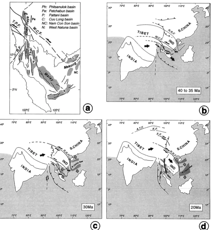
The indentation of India into Asia has induced large strain in Tibet and adjacent regions. In regions directly facing the Indian indenter, geophysical and geological evidence bring forth the importance of N-S crustal shortening. India's pene- tration has also produced a large amount of deformation on the sides of the collision zone. In particular, a part of the conver- gence has been taken up by the eastward expulsion of conti- nent-size blocks away from the path of India [Tapponnier et
a/., 1982, 1986; Peltzer and Tapponnier, 1988; Arrnijo et al.,
1989]. By successively pushing Indochina and Tibet/South China toward the ESE along great sinistral strike-slip faults, India removed a significant volume of Asian lithosphere from the frontal collision zone. This allowed transfer of part of the convergence-induced shortening toward the East. By the way of strike-slip motion, such shortening was transformed into crustal extension, seafloor spreading, and ultimately subduc- tion near the eastern tips of the strike-slip faults [Tapponnier
et al., 1986; Peltzer and Tapponnier, 1988; Briais et al., 1993].
One crucial tenet of this model, the Tertiary extrusion of Indochina and the concurrent opening of the South China Sea, is now corroborated by field and laboratory evidence on rocks
1 Laboratoire de Tectonique, M6canique de la Lithosphere; URA
1093, Centre National de la Recherche Scientifique, Institut de Physique du Globe de Paris.
2 Laboratoire
de G6ochronologie
G6ochimie
et P6trologie,
URA
5563, Centre National de la Recherche Scientifique, Universit6 Montpellier.
3 Geological
Survey
Division,
Department
of Mineral
Resources,
Bangkok, Thailand.
Copyright 1997 by the American Geophysical Union.
Paper number 96JB03831.
0148-0227/97/96JB-03831 $09.00
of the Ailao Shan-Red River shear zone along the northern
boundary of Indochina. Along this 1000 km long zone, 700
+200 km of sinistral motion occurred between --35 Ma and
17 Ma [Sch•irer et al., 1990; Harrison et al., 1992; Schi•rer et a/., 1994] by ductile shear within a 10 to 20 km wide zone [Tapponnier et al., 1990a; Leloup et al., 1995]. In Yunnan, this
Cenozoic left-lateral shear, and the coeval --E-W shortening
are the clearest Phanerozoic tectonic events. More to the
South, within Indochina, the major deformation phases are re- ported to be of Paleozoic or lower Mesozoic age [Bunopas,
1981' Seng6r and Hst;i, 1984' Hahn et al., 1986; Hutchinson,
1989; Ahrendt et •, 1993; Maluski et al., 1995a], but the im- portance of the Tertiary imprint remains to be assessed. The ages of the strike-slip faults and shear zones that affect the
Indochina block (Figure 1) are poorly constrained. Were such faults initiated by the India-Asia collision, as postulated by
Tapponnier et al. [1986] ? Was there north-south diachronism, from Thailand to eastern Tibet, in the onset of left-lateral strike-slip faulting? Finally, was the opening of the Cenozoic
basins of the Gulf of Thailand and of northern Thailand coeval
with such strike-slip movements? As a step to answer those
questions, and to better understand the timing of extrusion on the east side of India, we present here a structural analysis of the Wang Chao and Three Pagodas fault zones of NW
Thailand,
combined
with 4øAr/39Ar
dating
in these
zones
and
adjacent to them.Tectonic Setting
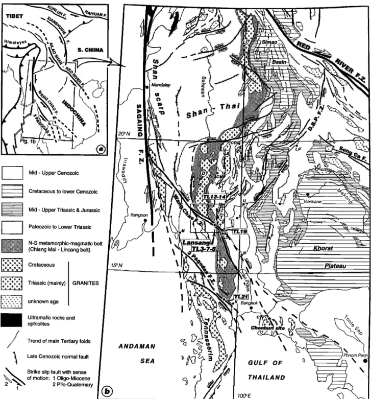
Overview of the Geology of NW Thailand
Located in the triangle-shaped northern corner of Indochina (Figure l a), NW Thailand is a mountainous region with mode-
rate elevation (culminating at Doi Inthanon, 2576 m, D on
Figure lb) and rocks of various types and ages [Baum et al.,
1970; Department of Mineral Resources, 1982; Hahn et al., 10,013
10,014
LACASSIN
ET AL.' TERTIARY
DEFORMATION
OF NW THAILAND
TIBET
S. CHINA
[
/
Mid - Upper Cenozoic
Cretaceous to lower Cenozoic
Mid - Upper Triassic & Jurassic
'Vientiane •
...
'"'":':•
Paleozoic
to
Lower
Triassic
I•'•':'"'"::'""•:•iii...."•iil
N-S
(Chiangmetamorphic-magmatic
Mai- Lincang belt)belt
,..,.,,,• Cretaceous
'+'+'+'+1
++++++++I Triassic (mainly) GRANITES
+4.+4.+4.+4.'11
[++•i,.
,•+
??++?+
t unknown
age
i
Ultramafic
rocks
and
... ophiolites
....'
ß
"
Trend
of main
Tertiary
folds
..- ...'
'• Late
Cenozoic
normal
fault
2••1•
Strike
of motion: 10ligo-Mioceneslip
fault
with
sense
2 Plio-Quaternary 15ON Bangkok,, ß Chonburi ANDAMAN <•
SEA
• •7.:•
GULF
OF
q
(•
100ø
E
THAILAND Oo .o Khorat ßFigure 1. Structural
and geological
sketches
of SE Asia showing
location
of studied
areas
in northwestern
Thailand.
(a) Map
of major
Cenozoic
faults
of mainland
SE Asia
and
eastern
Tibet
[after
Leloup
et al., 1995].
Arrows
show
senses
of finite
motion
on strike-slip
faults.
Boxed
area
refers
to Figure
lb. (b) Structural
sketch
map
drawn
from 1:5,000,000
scale
geological
map
of Asia [Department
of Mineral
Resources,
1982], Landsat
and
Spot
satellite
images,
ONC (Operational
Navigation
Chart)
and
TPC (Tactical
Pilot
Chart)
topographic
maps.
Geological
offsets
(solid
arrows)
are inferred
to have
occurred
coevally
with Tertiary
extrusion
of
Indochina
[Tapponnier
et al., 1986,
1990a;
Leloup
et al., 1995].
Present-day
senses
of motion
(open
arrows),
deduced
from
morphological
offsets
and
seismicity,
are opposite
to finite
geological
offsets
[Le Dain et al.,
1984].
Trends
of main
Tertiary
folds
(dotted
lines)
are
deduced
from
geological
maps
and
satellite
imagery.
TL3-7-8,
TL13-14,
TL19,
and
TL21
refer
to samples
dated
using
4øAr/39Ar
ttechnique
(see
also
Figure
2).
DBPFZ
is Dien Bien
Phu fault zone;
Li, La, D, and
T, Lincang,
Lampang,
Doi Inthanon,
and
Tak metamor-
phic
or magmatic
massifs;
U, Uttaradit;
CM, Chiang
Mai; CR, Chiang
Rai; S, Sukhothai;
N, Nakhon
Sawan;
K, Kanchanaburi;
C, Chonburi;
L, Loei;
P, Petchabun;
M, Moulmein;
LP, Luang
Prabang.
Boxed
area
refers
1986]. It lies --1500 km south of the eastern Himalayan synta- xis and 200 km east of the dextral Sagaing fault (Figure 1), present-day strike-slip boundary between India and Indochina. The most prominent structural feature of the region is the Chiang Mai-Lincang belt (CM-L belt), a north-south,--70 km wide anticlinorium of metamorphic and magmatic rocks (Figure lb). Toward the north, this belt forms the western bor- der of the folded, Mesozoic Simao basin (Figure lb), while south of the Gulf of Thailand it continues as the "main range batholith" along the Thailand-Malaysia border [Hutchinson, 1989]. This belt is offset by several strike-slip faults, the most prominent ones being the left-lateral Wang Chao and Three Pagodas fault zones (Figure lb). The metamorphic rocks are mostly high-grade paragneisses, orthogneisses and mica- schists. As they are locally overlain by less-metamorphic Paleozoic rocks, a Precambrian age has been ascribed to the gneisses and micaschists [Baum etal., 1970; Bunopas, 1981; Department of Mineral Resources, 1982; Hahn et al., 1986]. Contacts are generally faulted, however, and there is little evidence of stratigraphic conformity of the Paleozoic onto the gneisses [Bunopas, 1981; Hahn et al., 1986]. The high-grade metamorphic rocks pass to deformed migmatites and are in- truded by granitic plutons of mainly Permo-Triassic age [Braun et al., 1976; Beckinsale et al., 1979; Hahn et al., 1986]. According to Cobbing et al. [ 1992], syntectonic migmatization and granite intrusion correspond to two successive stages of the same event, pointing to a Permo-Triassic age, rather than Precambrian, for the high-grade metamorphism. Younger magmatic and metamorphic events are suggested by radio- chronologic studies and by the presence of Cretaceous or Tertiary granites in the CM-L belt [Cobbing et al., 1992; Dunning et al., 1995]. Larger Cretaceous to Paleogene granite plutons [Beckinsale et al., 1979; Hutchinson, 1989; Cobbing et at, 1992], offset left-laterally by the Three Pagodas fault zone [Tapponnier et al., 1986], are found west of the belt from west- em peninsular Thailand in the south to the Tenasserim moun- tains of southern Burma and perhaps along the Shan scarp region (Figure lb).
East of the CM-L belt, other large Triassic granite plutons have intruded the low-grade Paleozoic rocks of the Sukhothai fold belt [Department of Mineral Resources, 1982; Hahn et al.,
1986], between Sukhothai and Chiang Rai (S and CR, respec- tively, on Figure lb). Apart from a broad antiform of Siluro- Devonian rocks east of Chiang Mai (CM on Figure lb), the Sukhothai belt is chiefly made of upper Paleozoic to Meso- zoic series (Carboniferous-Permian; Lower-Middle Triassic; Upper Triassic to Jurassic, separated by unconformiies) of sedimentary, volcanic and volcaniclastic (rhyolitic and ande- sitic) rocks [Bunopas, 1981; Department of Mineral Resources, 1982; Hahn et al., 1986]. The latter Jurassic red bed series represents the southern extension of the Mesozoic to lower Cenozoic series of SW Yunnan (Figure lb). Likewise, most of the folds of the Sukhothai belt (Figure lb) prolongate those of the Simao basin where they are clearly due to Tertiary, ENE- WSW compression [Tapponnier et al., 1990a]. Across NW Thailand, the N-S trending fold axes are bent into an S shape along the strike-slip faults north of Chiang Rai (Figure lb). The folds are generally upright, though eastward to south- eastward verging folds are reported along the borders of the Sukhothai belt [Hahn etal., 1986]. Late Cenozoic grabens are localized along synclines of this former fold belt (Figure lb). The sharp morphology of some of the --N-S normal faults that
bound these grabens suggests that they are active. This tec- tonic style resembles that of Yunnan where active =E-W extension [Tapponnier and Molnar, 1977; Allen et al., 1984] overprints the earlier Tertiary ENE-WSW compressional structures with mid-Tertiary thrusts reactivated as Plio-
Quaternary normal faults [Tapponnier et al., 1990a; Leloup et
at, 1995]. N-S grabens also exist below the central Thailand depression, beneath Quaternary sediments and in the Gulf of Thailand [Polachan et al. , 1991 ].
The Sukhothai fold belt is bounded to the east by the right-
lateral Dien Bien Phu fault zone [Tapponnier et al., 1986],
whose trace is composed of several segments (Figure lb). Some of the segments are presently reactivated in a "rever- sed," left-lateral sense. NE of Uttaradit (U on Figure lb), a
belt of ultramafic and mafic rocks, associated with basaltic to andesitic metavolcanics, blueschists [Barr and Mac Donald,
1987] and turbidites, stretches parallel to the Dien Bien Phu
fault zone (Figure lb). This belt marks the suture zone bet- ween the eastern, active margin of the Shan-Thai block,
formerly the Sukhothai belt, and the passive margin of the
Kontum-Khorat block to the SE [Bunopas, 1981; Barr and Mac
Donald, 1987]. Subduction and subsequent collision probably
occurred between the Upper Permian and the Middle Triassic [Bunopas, 1981; Sengdir and Hsii, 1984; Barr and Mac Donald, 1987; Hutchinson, 1989]. East of this suture zone, the Loei
fold belt (L on Figure lb), affected by strong Triassic (Indo-
sinian) folding, also displays pre-Upper Devonian deformation and metamorphism and may follow a Paleozoic suture zone [Hahn et al., 1986]. Farther SE, post-Early Triassic folds and
thrusts are clear on seismic profiles of the Khorat plateau (Figure lb) where they are unconformably capped by the more
gently folded, Mesozoic to lower Cenozoic, Khorat red bed series [e.g., Mouret, 1994].
Previous Geochronological Studies in NW Thailand Most of the geochronological studies performed in Thailand
have been focused
on dating the various
granitoids
using Rb-
Sr whole rock isochrons, or K-Ar dating of minerals [Hahn et
at, 1986]. Some of the published
Rb-Sr ages [e.g., Braun et
at, 1976] are based on limited data sets, hence questionable
[Beckinsale et al., 1979]. Furthermore, K-Ar dating on min- erals is inadequate to unravel complex thermal histories and
may not date intrusion [Beckinsale et al., 1979].
Granitoids in the Chiang Mai-Lincang and Sukhothai belts have yielded Triassic ages ranging mainly between --240 Ma
and --200 Ma [e.g., Braun et al., 1976; Beckinsale et al., 1979;
Hahn et al., 1986; Cobbing et al., 1992]. For instance, the Tak
granodioritic to syenogranitic [Mahawat et al., 1990] batholith
(T on Figure lb) gave Rb-Sr ages between 208 +4 and 219 + 12 Ma [Beckinsale et al., 1979; Hahn et al., 1986]. The ages of the Lampang granite (La on Figure lb) fall in the
same range (212 +12 Ma [Beckinsale et al., 1979]). Toward the
north, the Lincang batholith (Li on Figure lb), yielded an
older age with a large uncertainty (270 +59 Ma, Rb-Sr [Liu Changshi et al., 1989]). South of the Gulf of Thailand, in the
Main Range batholith, U-Pb zircon dating (220 Ma to 198 Ma) confirms the Triassic age of the N-S magmatic belt
[Liew and Page, 1985; Hutchinson, 1989].
Reliable geochronological results on metamorphic rocks are sparse. One U-Pb zircon discordia from a sample of the Lansang gneisses (Tak-Mae Sot section, Figures 2 and 3)
10,016
LACASSIN
ET AL.' TERTIARY
DEFORMATION
OF NW THAILAND
ooo oooooooooooooo• •,o . ooooooooo I , oo oooooooooooooo ooo -~.. ooooo(•oooo ooooooooooooo ooo ooo ooooooooooooooooooooooooooo•ooooooooooooooo o ooooooooooeoooo oooo(• ooooooooooo ... :/::: ... '• •ooo• ... • ... oo•OOOOOOOOOOOOO oo o,o ooooo, oooooooooooooooøøøøøiøøøøøoooooo
ooooooooo/ooooo oooo• oooooooooo ooooo ooooooooooooooooo ooo oooooooooooooooooooooo oooooooooooooooooooooooSPOT K.J. 257~316 & 258~317
km
o I 2
i ! i
...
:,"'* ...
:
....
i.::L,•7"
? section
of Fig.
4
--"-.-,.,•.. '" U/Pb et al., 1993) km o 1 2 i I I Ordovician • .-. "::'5
'"• Mylonitic
metasediments
'-<.. foliation strike...
structural
directions
(foliations)
Figure 3. (a) Part of Spot K.J. 257-316 and 258-317 images showing Lansang park and Tak-Mae Sot highway
area. (b) Geological interpretation drawn from SPOT images and map of Campbell [1973]. Lansang mylonitic
gneisses are in grey. Foliation trends drawn from field measurements and SPOT images. Location of dated samples (TL3, 7, 8, TA34) and approximate location of U/Pb dated sample from Ahrendt et al. [1993] are shown. TA39 refers to sample of figure 8d. Site h7 along Huai Lansang corresponds to site of strain measure- ments of Lacassin et al. [ 1993].
10,018 LACASSIN ET AL.; TERTIARY DEFORMATION OF NW THAILAND
gave an imprecise lower intercept age around 200 Ma
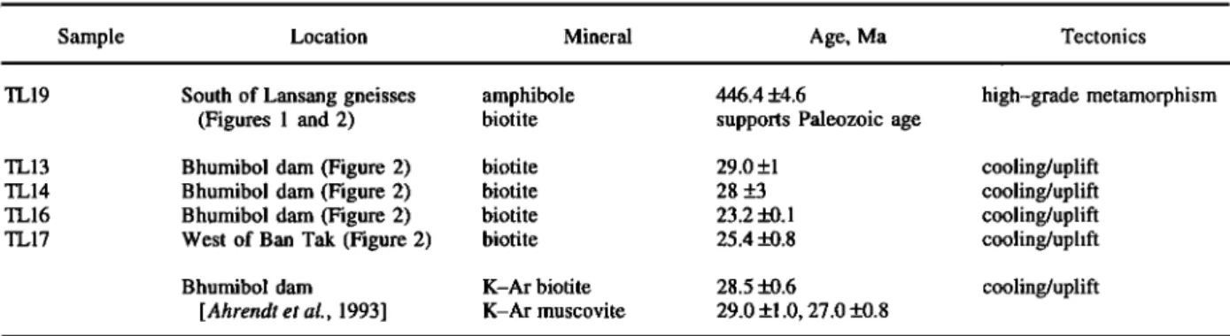
[Ahrendt et al., 1993]. K-Ar ages on biotites and illites from
these gneisses (31.9 Ma to 29.6 Ma) are interpreted to result
from Tertiary cooling [Ahrendt et al., 1993]. Other Tertiary K-
Ar ages on biotites and muscovites (27 to 29 Ma) are reported from the eastern border of the Chiang Mai-Lincang belt at the
Bhumibol dam (Figure 2) and farther north near Hot and Chiang Mai (18 to 22 Ma) [Braun et al., 1976; Ahrendt et al., 1993]. In the region west of Chiang Mai, U-Pb dating of orthogneisses from the Doi Inthanon range (D on Figure lb) yielded zircon lower intercept ages between 211 and 203 Ma, representing the age of the granitic intrusion [Dunning et al.,
1995]. Monazites gave nearly concordant U-Pb ages of
84 +2 Ma and 72 +1 Ma, interpreted as the age of the high- grade metamorphism [Dunning et al., 1995]. The Mae Klang
granite, which intrudes the eastern border of these gneisses,
yielded concordant monazite and zircon results with an age of
26.8 +0.5 Ma [Dunning et al., 1995]. This latter granite is inter-
preted to have been emplaced during Oligo-Miocene low-
angle normal faulting concurrent with the uplift of the high-
grade gneisses [Mac Donald et al., 1993; Dunning et al., 1995].
More to the south the Thabsila gneisses [Bunopas, 1981] that form fault-bounded slivers within the Three Pagodas fault zone, yielded Rb-Sr ages of 391 Ma and 560 Ma at two dif- ferent locations [Bunopas, 1981]. K-Ar dating of biotites from these gneisses, however, gave Tertiary ages of 36 +1 Ma, 33 +2 Ma [ Bunopas, 1981]. These results suggest that the Chiang Mai-Lincang belt, site of Triassic granite emplace- ment, has suffered Upper Cretaceous and Tertiary deformation and metamorphic events whose importance and kinematics need to be assessed more precisely in many places.
Wang Chao, Three Pagodas Fault Zones and Adjacent
Geological Units
The Wang Chao (also called Mae Ping or Papun) and Three Pagodas fault zones extend for about 450 and 250 km, respectively (Figure lb). They probably continue toward the SE under the Chao Praya plain and in the Gulf of Thailand
[Bunopas, 1981' Tapponnier et al., 1986]. Both zones are com-
posed of several strands striking NW-SE on average, roughly parallel to the Red River fault zone (Figure lb). They cut and offset left-laterally the Chiang Mai-Lincang belt (Figure lb), and distort the post Jurassic N-S trending fold axes [Le Dain et
d., 1984; Tapponnier et al., 1986]. Tapponnier etal. [1986] and Peltzer and Tapponnier [1988] thus inferred that the total left-
lateral offset (=300 kin) on these fault zones was a result of the Tertiary indentation of India within Asia. North of Chiang Mai, smaller conjugate dextral faults also offset the N-S metamorphic belt and bend the fold axes (Figure lb). That segments of these faults are active is suggested by their sharp traces and the presence of river offsets on Landsat and SPOT images. The present-day slip senses deduced from such mor- phological offsets, however, are opposite to the finite geologi- cal offsets (Figure lb). The way in which the =N-S trending Quaternary normal faults and grabens branch on these strike- slip faults (Figures lb and 2), and fault plane solutions of
earthquakes [Le Dain et al., 1984] confirm the present-day slip
senses. As in Yunnan, the upper Cenozoic deformation is thus compatible with E-W extension and N-S compression, per- pendicular to the former mid-Cenozoic E-W shortening.
West of Kanchanaburi (K on Figure lb), geological maps
[Bunopas, 1976; Department of Mineral Resources, 1982;
Siribhakdi et al., 1985] show a 25 km wide zone of NW striking fault-bounded slivers parallel to the trend of the Three Pagodas fault zone (TPFZ). Most of these slivers are made of Permian or Triassic limestones, but metamorphic rocks (gneisses, quartzites, marbles) mapped as Precambrian
(Thabsila gneisses) or lower Paleozoic [Bunopas, 1976] are
exposed discontinuously in this zone. These metamorphic rocks generally show steep foliations and horizontal stretching lineations, both trending NW-SE parallel to the TPFZ. In some gneisses the lineation forms spectacular rods parallel to the fault zone. In this zone we sampled an orthogneiss to assess the age of metamorphism and deformation (Figure lb).
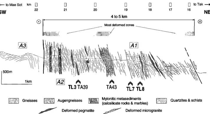
Along the Wang Chao Fault zone (WCFZ), deformed rocks are exposed in the region of the Lansang National Park, SW of Tak (Figures lb and 2). There a 5 to 8 km wide belt of my- lonitic gneisses (Lansang gneisses) may be traced for about 130 km on geological maps and SPOT images (Figure 2). The fabric of the gneisses is clear on the images, everywhere nearly parallel to the boundaries of the gneiss belt and to the foliation and lithological banding observed on the outcrops (Figures 2 and 3). This belt is bounded to the SW by a steep fault zone with a sharp trace on SPOT images (Figures 2 and 3). Near the Lansang Park and for about 30 km north- westward, the rather steep northeastern range front, incised by small canyons, is marked by triangular facets (Figure 3). Such morphology implies recent uplift of the gneiss core by normal movement on the NE dipping fault that bound the gneisses to the NE (Figures 2 and 3). SPOT images show another NE dip- ping normal fault, also marked by triangular facets, within the gneisses (Figure 3). This fault limits to the NE the waterfalls of Huai Lansang, which are restricted to its footwall attesting
for throw. South of the Mae Nam Tun valley (Figure 2), right-
stepping fault segments, striking more easterly, form the north- ern boundary of the gneisses and cut across the mountain range. The Lansang gneiss core pinch out NE of Tha Song Yang (Figure 2). Still farther NW, the WCFZ is marked by parallel NW-SE striking faults, and by elongated hills of Triassic limestone along Mae Nam Moei river (Thai-Burma
border). We have studied the deformation of the Lansang
gneisses and mylonites along two sections SW of Tak (Lansang-Mae Sot road, Huai Lansang sections, Figure 3). Lansang Mylonitic Gneisses
Earlier work: Petrography and general structure. The Lansang gneiss core is made of strongly deformed metasedi- ments (quartz-feldspar-biotite (Q-F-Bi) paragneisses, mica- schists, calcsilicate rocks, marbles), orthogneisses, and veins of pegmatite, quartz and microgranite [Campbell, 1973]. All these rocks dip steeply (>45 ø ) toward the northeast (Figure 4). The most frequent rocks are the Q-F-Bi gneisses, often migmatitic, that locally bear garnet, hornblende, and silli-
manire [Campbell, 1976]. The calcsilicate rocks and marbles
occur as bands of laminated mylonites parallel to the foliation and to the compositional layering of the surrounding gneisses (Figures 3, 4, and 5a). These rocks are interbanded with para- gneisses and micaschists and with deformed pegmatite veins and orthogneisses (Figures 4 and 6). The close association of these rock types suggests a metasedimentary origin for the Q-
F-Bi gneisses [Campbell, 1973]. The calcsilicate rocks, made of alternating green and purplish-brown bands, bear quartz,
plagioclase, pyroxene, hornblende, calcite, _ muscovite and phlogopite, _ garnet [ Campbell, 1976]. In these rocks, micro-
-• to Mae Sot
sw
km
21 20 19
4to5 km
Most deformed zones :::::::::::::::::::::::::::::::::::::::::::::::::::::::::::::::::::::::::::: • •i:i:i:i:i:i:i:i:i:i:i:i:!:i:i:i:i:i:i:!:i:i:!:!:i:i:i:i:i: :i 18 17 •] to Tak 16
TL
3 TA39
TA43 TL
7 TL
8
NE Mylonitic metasedimentsGneisses
":•"• Augengneisses
•!'•• (calcsilicate
rocks
&
marbles)
[••[ Quartzites
&
schists
...fJ Deformed
pegmatite
..•:••'" Deformed
microgranite
Figure 4. Geological section of Lansang mylonitic gneisses along Tak-Mae Sot highway (located on Figure 3b). Arrows labeled TL3, TL7, and TL8 locate dated samples. TA39 and TA43 correspond to samples of
Figures 8d, and 8a, respectively. Sites of K-Ar dating of [Ahrendt et al., 1993] are named A1, A2, and A3 (see
text and Table 1). Most deformed zones are defined by prominent mylonitic textures, banding, and stretching lineations. On top, numbers 16 to 22 show approximate location of kilometer marker along road.
probe analyses (amphibole/plagioclase thermobarometry) yiel-
ded an estimate of 800 +50øC for the high-grade meta-
morphism [Martelet, 1994]. The marble bands are made of a
laminated dark gray rock bearing 90% of cal cite (+ quartz,
feldspars, amphibole, phlogopite) [Campbell, 1976]. They contain up to 1 m wide boudins of calcsilicate rocks and of leucocratic granite (Figure 5f). A =500m thick band of
calcsilicate and marble rocks is found in the middle of the
gneiss core along both the Tak-Mae Sot road and Huai Lansang sections (Figures 3b, 4, and 6). Metaigneous rocks comprise leucocratic gneisses and deformed pegmatite veins as well as granodioritic intrusions [ Campbell, 1976]. Most are
affected by penetrative deformation. According to Campbell, high-grade metamorphism, migmatization, and emplacement
of leucocratic intrusions during the Precambrian would have been followed by intrusion of granodioritic rocks and by "postmetamorphic" mylonitization in the Paleozoic. The U- Pb age obtained by Ahrendt et al. [1993] on the gneisses possi- bly suggests, however, that high-grade metamorphism occur-
red around --200 Ma.
Characters of the ductile deformation. A major penetra- tive, ductile deformation, with steep foliations and nearly horizontal lineations (Figures 4, 5b, 6, and 7), affects all rock
types of the Lansang gneisses. This deformation is particularly
strong in the most deformable calcsilicate and marble band in the central part of the gneiss stripe (Figures 5a and 5d). On
fiver-polished outcrops of Huai Lansang (site h4, Figure 6, for instance), they show clear macroscopic evidence of intense, nearly horizontal stretching and shear, including decimetric
sheath folds, asymmetric boudinage with widely pulled-apart elements, meter-scale shear zones, rolling structures, and a
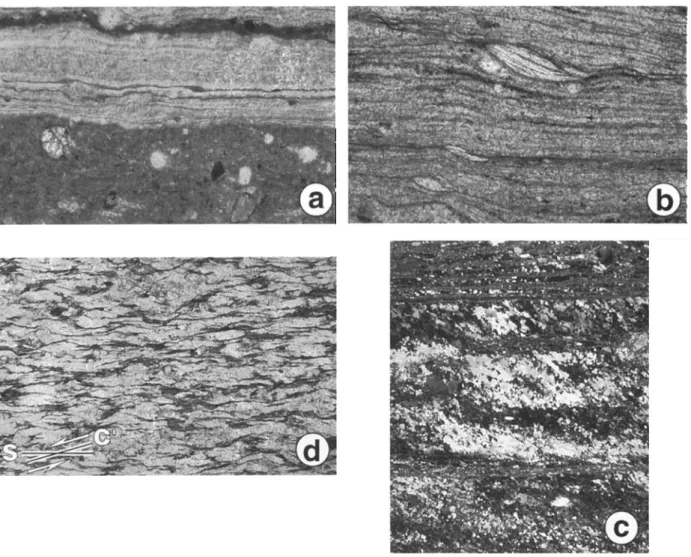
prominent lineation (Figure 5b). Stretched garnets locally form thin elongated pink ribbons within these rocks. Under the microscope, the alternating white and darker bands of calc- silicate rocks appear extremely fine grained (Figure 8a). The finely laminated white bands, made of quartz and feldspar, bear stretched feldspar porphyroclasts commonly with elon- gated asymmetric tails. The darker bands are made of a fine- grained, calcitic matrix, embedding small rounded porphyro- clasts of K-feldspar, plagioclase, hornblende, pyroxene, epidote, garnet and quartz of relatively homogeneous size (80to 200gm) (Figure 8a). The gray marbles present a similar microstructure with again a very small size of the
calcite crystals within the matrix. This may suggest that grain
boundary sliding or perhaps cataclastic shear has been a
dominant deformation mechanism in these calcitic bands and
that mylonitization has not been accompanied or followed by calcite recrystallization.
Most of the paragneisses, micaschists, and orthogneisses are mylonitic and show left-lateral shear bands (Figure 5e). The granitic and pegmatitic veins are generally as deformed as gneisses. Horizontal outcrops usually show these veins cut by shear planes and highly stretched [Lacassin et al., 1993], while vertical sections perpendicular to lineation display
folded veins (Figure 5c). Under the microscope, the gneisses
generally bear biotite that outlines the foliation and the shear planes and marks the stretching lineation together with elon- gated ribbons of quartz and feldspars. Muscovite occurs as sheared asymmetric crystals (Figure 8c) and may form trails of pulled apart fragments. Quartz rich gneisses and micas- chists often bear ribbons of elongated quartz crystals with a clear shape fabric oblique to the foliation and banding of the rock (Figure 8c).
a. o • 0 '"-- Z• ======================================== • ======================================== • '-•;-'-•.'===================== c• z E
10,022 LACASSIN ET AL.: TERTIARY DEFORMATION OF NW THAILAND
N
N
N
(•
Tak-Mae
Sot
road
. (Lansang region, Fig. 3) (Lansang region, Fig. 3)
Figure
7. Measurements
of foliation
and lineation
trends
in Lansang
mylonitic
gneisses
(Schmid
net, lower
hemisphere):
(a) along Huai Lansang
River and (b) along
Tak-Mae Sot Road. (c) Lineation
and foliations
in
probable
southeastward
extension
of Wang
Chao
shear
zone
near
Chonburi
(Chonburi
site
on Figure
lb).
Close to the SW border of the gneisses, the banding of the rocks and the foliation planes are steep to nearly vertical (Figure 4). They flatten a little toward the NE and dip 45 to 60 ø NE in the NE half of the gneiss stripe (Figure 4). More gently dipping foliation planes are locally found where meter to 10 m scale folds fold the foliation. In spite of these varia- tions in dip, the foliation planes always strike nearly parallel to the trend of the gneiss belt (Figures 3b, 6, 7a, and 7b) and bear everywhere a gently plunging stretching lineation (Fig- ure 5b, 6, 7a, and 7b). Plunges of the lineation generally range between 0 ø and 20 ø toward the SE (Figure 6, 7a, and 7b).
Evidence for intense left-lateral shear. Clear shear sense
indicators are found along Huai Lansang (Figure 6). There the
detailed
study
of more than 25 river-polished
surface
outcrops
yields systematic, left-lateral, macroscopic shear senses, confirmed by microstructural observations made on polished samples and under the microscope. Shear senses are deduced from various shear criteria [e.g., Hanmer and Passchier, 1991 ]. C/S and C'/S microstructures [Berth• et al., 1979a, b] are
common in gneisses (Figures 5e, 5g, and 8d), for instance, at
sites h 1, h2, h3, and h5 (Figure 6). Feldspar porphyroclasts are stretched, forming elongated, asymmetric tails commonly with
well-developed rolling structures [Van Den Driessche and
Brun, 1987; Hanmer and Passchier, 1991]. At site h6 (Fig- ure 6), in marbles, stretched leucogranite or quartz veins form
meter-scale rolling structures in which rotated boudin
fragments are connected by elongated tails (Figure 5f). Asym- metric foliation boudinage also give consistent left-lateral shear sense [Platt and Vissers, 1980; Gaudemer and Tappon- nier, 1987]. Under the microscope (Figure 8), shear senses are given by rolling structures, asymmetric boudinage of porphy- roclasts, C or C' planes, deformed mica fishes [Hanmer and
Passchier,
1991], and oblique
shape
fabrics
of quartz [Brunel,
1980]. Along the Tak-Mae Sot road, determination of shear senses was more difficult in the field because of the lack of
nearly horizontal
outcrops,
but the microstructural
study of
collected samples confirms the left-lateral shear sense.
The small-scale
mylonitic
banding
of the rocks,
the strong
deformation
of porphyroclasts,
which are often elongated
and
exhibit long tails, the pervasive
occurrence
of asymmetric
boudinage
and C/S microstructures
are qualitative
indicators
of the intensity of ductile strain. Decimetric sheath folds re- folding the mylonitic foliation are found in the central calc-
silicate band along both Huai Lansang (waterfalls 2 and 3,
Figure
6) and Tak-Mae Sot road, together
with folds parallel
to the lineation (a folds). At site h5 along Huai Lansang
(Figure
6), large-scale left-lateral foliation boudinage
is
combined
with such folds, thus forming complex
3-D struc-
tures.
Some of these
structures
refold already
foliated
marbles
with boudins
of mylonite,
pegmatite,
or quartz.
Together
with
the widespread
occurrence
of mylonitic
fabrics,
the presence
of sheath
folds and a folds is consistent
with intense
progres-
sive shear [Cobbold and Quinquis, 1980; Lacassin and
Mattauer,
1985; Malavieille, 1987]. At the macroscopic
scale
the surface-balanced restoration of stretched veins from the
northeastern
part of the gneiss
stripe
(site
h7, Figure
3) provi-
des minimum
estimates
of the extension
suffered
by these
veins (265 to 786%) [Lacassin et al., 1993]. In the central calc-
silicate
bands,
restoration
of stretched
porphyroclast
using
the
same technique gave extension values of at least --450 to
865% [Martelet, 1994]. Assuming
simple shear, these exten-
sion values imply lower bounds of 7 to 9 _+ 3 for the shear strain (¾) [ Lacassin et al., 1993; Martelet, 1994].
Nature of the Wang Chao-Lansang shear zone. The
presence of widespread mylonitic fabrics with foliations,
stretching lineations, and left-lateral shear criteria consistent
from the microscopic
to the regional
scale imply that large
sinistral
shear
occurred
in the Lansang
gneiss
belt and led us
to conclude that this belt is a major left-lateral ductile shear zone (the Wang Chao-Lansang shear zone). There is no clear
evidence
that would permit to infer that early shear
increments
have
occurred
in this zone under
high-temperature
conditions
as in the Ailao Shan-Red River shear zone [Leloup
and
Figure 8. Microstructural characters of Lansang gneisses. (a) Mylonitic calcsilicate marbles (sample TA43, located on Figure 4). White quartzo-feldspathic ribbons alternate with darker bands made of fine-grained calcite matrix embedding rounded porphyroclasts (clinopyroxene, plagioclase, hornblende, K-feldspar, quartz, epidote). (b) Mylonitic paragneiss with sheared asymmetric muscovite crystals (sample TA30, located on Figure 6). (c) Mylonitic micaceous quartzite (sample TA31, located on Figure 6). Ribbons of recrystallized quartz grains with elongation oblique to ribbon edges and foliation. Sense of obliquity implies left-lateral shear. (d)C'/S gneisses (sample TA39, located on Figure 4) with left-lateral shear planes deforming biotite crystals.
assemblages are found in porphyroclasts (e.g., Figure 8a) and the pegmatitic and granitic veins are always deformed, sug- gesting that their emplacement predated most of the sinistral shear increments. On the other hand, progressive left-lateral shear clearly occurred under decreasing P/T conditions. Shear planes present various obliquities relative to foliation planes, ranging from nearly parallel to 200-40 ø (Figure 5e, 5g, and 8d). The oblique shear planes generally strike more east- erly (N120øE on the average) than the regional trend of the Lansang gneiss stripe, suggesting that they represent C' planes [Berthd et al., 1979b]. Some of the latest brittle-ductile left- lateral shear planes contain chlorite. Brittle-ductile shear zones, with evidence of cataclasis at decimetric scale, also affect the calcsilicates and marbles (Figure 5d). In these rocks, more penetrative low-temperature deformation, with
possibly cat•c. lastic shear, might have occurred in the fine- grained ribbons embedding rounded porphyroclasts
(Figure 8a). This body of evidence implies that progressive left-lateral shear, or at least late shear increments, occurred
along a retrograde P/T path and were still ongoing at tempera- tures below the brittle-ductile transition in presently exposed
rocks. Locally, in the northeastern part of the Lansang gneiss
stripe, foliation planes bear chlorite-bearing down-dip slick-
ensides due to normal, down to the NE, slip. Though minor compared to the ductile sinistral shear, these structures sug- gest that the gneisses have been brought to the surface by late normal faulting as for the Ailao Shan-Red River shear zone [e.g., Leloup et al., 1995].
Chiang Mai-Lincang Belt Between the Lansang Area
and Bhumibol Dam
To constrain the structure and age of the gneisses of the N-
S metamorphic belt cut and offset by the WCFZ (Figure lb),
we sampled metamorphic rocks on either side of the Lansang gneisses, mostly where easily accessible, to the north (Figure 2). Between Sam Ngao and the Bhumibol dam, a --5 km long section cuts steeply dipping metamorphic rocks
10,024 LACASSIN ET AL.: TERTIARY DEFORMATION OF NW THAILAND (Yan He complex [Bunopas, 1981]) west of the late Cenozoic
active Sam Ngao normal fault (Figure 2). Near the dam, the section exposes vertical schists, quartzites, quartz-bearing marbles, and rhyolitic to andesitic tufs with small feldspar porphyroclasts. These different rock types are finely inter- mixed, with 10 cm to 1 m scale banding. They display a verti-
cal bedding parallel foliation (S0/]) striking N175øE on the
average. This foliation is strongly crenulated by folds with nearly horizontal axial planes, defining a N-S horizontal lin- eation. East of the dam series, one finds reddish schists (metapelites?) and a series of micaschists, metagreywackes, and quartzites. As at the dam, these rocks show steep bedding parallel cleavage affected by microfolds with N-S axes and a horizontal strain-slip cleavage (S 2) parallel to their axial planes. That micaschist sequence is bounded to the east by quartz-bearing marbles dipping steeply toward the east. The eastern part of the section is made of augengneisses, followed by low-grade schists and sandstones (Cambrian [Bunopas, 1981]), separated from the gneisses by a postmetamorphic fault. These moderately deformed gneisses form N-S striking rods with poorly defined foliation. Occasional garnet, silli- manite, andalusite, and cordierite are reported in the gneisses and micaschists [Bunopas, 1981]. Since we found no evidence of shear along this section, it seems probable that the rods in the gneisses, and the crenulation lineation in the quartzites, marbles, and schists mark fold axes rather than a strike-slip
direction.
South of the dam section, west of Ban Tak, a large river bed outcrop also displays deformed metamorphic rocks (TL17 on Figure 2). The large-scale fabric, parallel to the Son folia- tion, may be followed in continuity from the dam section to this outcrop on the SPOT images (Figure 2), suggesting that both expose the same sequence. The eastern part of the out-
crop is made of granite cut by nearly vertical brittle-ductile
left-lateral shear zones and en 6chelon veins striking
=N140øE,
and N120øE, respectively.
To the west, the granite
intrudes a metasedimentary series made of alternating bands
of grey to green quartzites, schists, marbles and calcsilicate
bands bearing quartz, K-feldspar, plagioclase, pyroxene, car- bonates, and + garnet [Martelet, 1994]. Some bands bear large (1 to 10 cm) pink poecelitic garnets. In these rocks, the folia- tion strikes N-S on the average, dipping 70 ø toward the west, and bears a weak lineation plunging 40 ø to 60øS. The western part of the outcrop displays migmatitic gneisses and ortho- gneisses, with N10øE striking, vertical foliations, and lineation plunging =50øS. Deformed and undeformed veins of pegmatite and quartz intrude the metasediments and the gneisses.
The border of the Chiang Mai-Lincang belt thus displays different rock types (calcsilicates, marbles, quartzites and mi- caschists, migmatitic gneisses and orthogneisses intruded by
pegmatitic and Quartz veins), mostly undeformed to moder-
ately deformed. These lithologies resemble those found my- lonitized within the Lansang gneisses. In particular, the green
metasediments bearing large garnets found west of Ban Tak
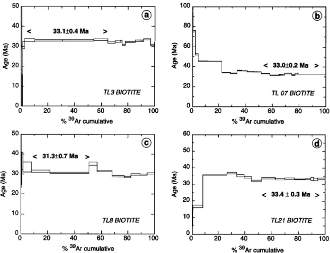
50 40 •' 30 < 20 10 0 0 50 40 •, 30 o• 20 10_ < 33.1+0.4 Ma > TL3 BIOTITE , I , I • I , I • 20 40 60 80 100
% 39Ar
cumulative
< 31.3_0.7Ma > - TL8 BIOTITE lOO 80 •' 60 v40
20 0 0 60 50 40•- 30
20 1033.0+0.2
Ma
TL 07 BIOTITE I I I I I I i I 20 40 60 80% 39Ar
cumulative
100 < 33.4+0.3Ma > TL21 BIOTITE I I I I I I I I I 0 I I I I I I I I I 20 40 60 80 100 0 20 40 60 80% 39Ar
cumulative
% 39Ar
cumulative
lOO
Figure
9. Results
of 4øAr/39Ar
biotite
dating
from
Wang
Chao
shear
zone
(samples
TL3, TL7, and
TL8) and
Three Pagodas fault (sample TL21). Samples located on Figures 2, 3b, 4, and 6.could represent the parent rock type of the thinly banded green, grey, and brown mylonites of the central part of the Lansang gneiss stripe.
Age of Tectonometamorphic Events
We have dated metamorphic minerals from 11 samples of the Lansang mylonitic gneisses and other geological units
nearby
(located
on Figures
lb, 2, and
3b) using
the 4øAr
/39Ar
technique. The description of the dated samples and the fac-
tual presentation of the results and age spectra are given in
the appendix. These results are graphically displayed on Figures 9 to 11 and summarized on Tables 1, 2, and 3. Analytical results are available on IPGP web site (http://www. ipgp.jussieu.fr/depts/tecto.html) or on request to the authors.
Early Oligocene Sinistral Shear Along the Wang Chao and Three Pagodas Faults
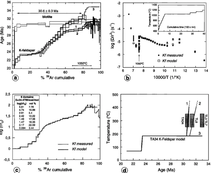
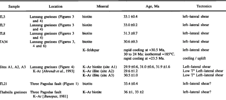
Biotites from the four samples of the Lansang gneisses yielded clustered results. Plateau ages, calculated for the flat part of the spectrum, are close to 33 Ma for TL3 and TL7, 31.3 Ma for TL8, and 30.6 Ma for TA34 (Figure 9 and Table 1). For TL3, TL8, and TA34, the total ages, calculated for the whole spectrum, are close to plateau ages (Table 1). Except for TL7, isochrons ages calculated from the inverse correlation plots are comparable, within uncertainties, to
plateau
ages,
and 4øAt/36At
ratio are close
to the atmospheric
ratio (Table 1).
Modelization of the TA34 K-feldspar spectrum assuming a discrete distribution of domain sizes for argon [Harrison et al.,
1991; Lovera et al., 1991] provides a reasonable fit of the re-
36 • • • • -2
34
[-
30.6
+
0.3
Ma
,, ...:i!?
....
3
-3 32 30'
5-4
'•' 28 '• -5 "• 26 24 -6 2220
•W
, 1050':'0
, '
-7
0 20 40 60 80 100•)
% 39Ar
cumulative
6 400 200 000 800 600 Cumulative time (100 x mn) 400 I , I • I , 0 10 20 30øt,
I
[] Kf modelß Kf
measured
1050øC I I I I I I I , 7 8 9 10 11 12 13 10000/T (1/øK) 14 2,5 , 500 1,5 0,5 -0,5 8 domains E--34.4756 kcal/mol Iog(r/ro) vol % 5.61 7.78 4.74 16.88 3.81 5.4 2.42 10.22 1.48 17.36 1.47 16.35 0.17 22.59 0.094 3.44 .• 300• 200
- E Kf measured I-- Kf model - 400 100TA34 K-Feldspar model
20 40 60 80 100 20 22 24 26 28 30 32
•)
% 3eAr
cumulative
(•)
Age
(Me)
Figure 10. 4øAr/39Ar
results
obtained
on TA34 sample
(Wang
Chao
shear
zone,
located
on Figure
3b and 6).
(a) Age spectra of biotite and K-feldspar. Shaded curves show modeled K-feldspar age spectra for thermalhistories
1 to 3 of Figure
10d. (b) and (c) Fit of model
and data
on the Arrhenius
plot calculated
from
39At
dif-
fusivities (Figure 10b), and on the log (r/to) plot (Figure 10c). On Figure 10b and 10c, inserts show used thermal heating procedure and domain characteristics, respectively. (d) Thermal histories inferred from K-feldspar results. Solid lines show the three thermal histories discussed in text (fit to age spectrum is shown on Figure 10a). Only thermal histories 1 and 2 fit both K-feldspar and biotite results. Boxes show results of biotite dating (Tables 1 and 2) with closure temperature of biotite taken to be 300 _+50øC.
;2
10,026 LACASSIN ET AL.: TERTIARY DEFORMATION OF NW THAILAND o o [ I ' I' [ I I • I ' I I I C• , I , ,I , , I [ I [ 0 0 0 0 0 0 0 CO [43 •' ('0 OJ ,,-- (elAI) o
]
I(•l [ I ' I ' I ' [ [ [ ' [ •
- ,• 0 0 0 0 C) 0 0 CO OJ O0 •' (m) e6v [ I [ I [' I© ^
I • I ] I [ I . II , i , i , [ , i.. ,'--'-:-p ,, I , i 0 0 0 0 0 0 0 0 0 0 0 0 0 0 0 0 (•) i i (eR) eSv c)• i , i i i • i ,' i • i •,/• , i • i • o
o
• +1 ½___.. v c)•1 • , i • i ,• i , i , i , i • I • i ,
c) 0 0 0 0 0 0 o r4D O4 01D •!' (e•) c) 0 0 0 0 0 0 0 0 0 0 0 0 0 0 0 0 0 (•IAI)Table 1. Results
of 4øAr/39Ar
Dating
on Biotites
and
Amphibole
, ..
Sample Plateau Age, Ma Total Age, Ma Isochron Age, Ma
, TL3 biotite 33.1 + 0.4 32.6 + 0.4 33.0 + 0.3 TL7 biotite 33.0 + 0.2 37.0 + 0.2 (30.0 + 0.5) TL8 biotite 31.3 + 0.7 31.2 + 0,7 31.4 + 0.3 TA34 biotite 30.6 + 0.3 30.5 + 0.5 31.4 _+ 1.8 TL 13 biotite 29 + 1 46.2 +_ 3.5 27.3 + 0.6 TL14 biotite 28 + 3 44.6 + 3 26.2 + 1 TL 16 biotite 23.2 + 0.1 24.3 + 0.1 23.0 + 0.6 TL17 biotite 25.4 ñ 0.8 28.1 + 0.6 (27.2 + 0.6) TL 19 biotite 359 + 6 TL19 amphibole 464.4 + 4.6 438.2 _+ 3.5 450 _+ 5 TL21 biotite 33.4 + 0.3 32.7 + 0.8 (32.6 + 0.5) 4øAr/36Ar 294 + 5 (1848 + 50) 288 + 9 286 +_ 5 324 + 15 344+ 10 335 + 10 (227 + 12) 262 ñ lO (320 +_ lO)
Results for plateau ages are those retained for the age of the mineral. Values in parentheses are not significant (data clustering on isochron).
sults (Figure 10) for eight domains with a common activation energy of 35.5 kcal/mol. Such activation energy is quite low for K-feldspar (commonly 40 to 55 kcal/mol) but leads to a good fit to the experimental Arrhenius plot, except for the last 10% of Ar release (Figures 10b and 10c). Taking these do-
main characteristics (Figure 10c), theoretical age spectra [Lovera et al., 1991] have been calculated for three possible
cooling histories (Figures 10a and 10d). For cooling histories 1 and 2 (Figure 10d) we have not attempted to model the bump in the age spectrum, likely due to excess argon [Foster et al.,
1990]. This lead to modeled spectra shortcutting this bump
(Figure 10a). These very similar thermal histories imply rapid cooling from --400øC to =185øC starting between 32.5 and 31 Ma (histories 2 and 1, respectively, Figure 10d) in order to fit the last 16% of Ar release (Figure 10a). After this rapid cooling and a first isothermal step (--185øC), a second phase of cooling occurs at 23.5 Ma before the final isothermal step (--75øC). Assuming closure temperature of 300 +50øC for biotite, the age of TA34 biotite lie on, or is very close to, cooling curves 1 and 2 (Figure 10d). Note finally that an at- tempt to model the bump in the age spectra by neglecting the
last 16% of degassing gave a cooling history unconstrained at high temperature and incompatible with biotite ages (curve 3, Figure ! 0d).
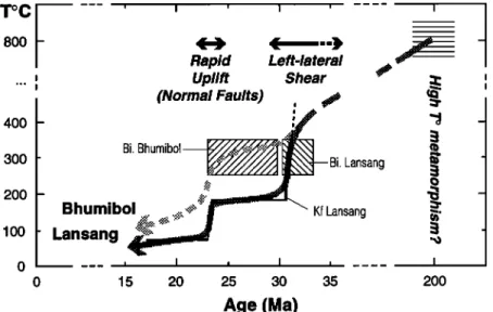
In view of the intense shear strain of the rocks, and of the retrograde character of the late deformation structures, we in-
fer that the biotite ages obtained in the Lansang gneisses (33
and 30,6 Ma, Table 2) date the late stages of ductile left- lateral shear along the Lansang-Wang Chao fault zone. The thermal history deduced from TA34 K-feldspar dating and modeling supports this view (Figures 10 and 12). It shows that rapid cooling from --400øC down to 185øC, thus probably lower than the brittle-ductile transition, occurred around
31 Ma. This rapid cooling was probably coeval with the last
increments of ductile left-lateral shear (Figure 12). The bio- tite of the same sample gives an age of 30.6 Ma in full agree- ment with the feldspar thermal history (Figure 10). The other samples give slightly different biotite ages (Table 1 and Fig- ure 10d), suggesting that thermal histories and times of biotite closure for argon differed somewhat from place to place along section, or along strike in the gneisses, as in the Ailao Shan- Red River shear zone [Harrison et al., 1992, 1996].
Table 2. Summary of Dating Results on the Wang Chao and Three Pagodas Fault Zones
Sample Location Mineral Age, Ma
TL3 Lansang gneisses (Figures 3 biotite 33.1 _+0.4
and 4)
TL7 Lansang gneisses (Figures 3 biotite 33.0_+0.2
and 4)
TL8 Lansang gneisses (Figures 3 biotite 31.3 _+0.7
and 4)
TA34 Lansang gneisses (Figures 3, biotite 30.6 _+0.3
4 and 6)
K-feldspar rapid cooling at =30.5 Ma,
30 to 24 Ma: isothermal =185øC.
rapid cooling at =23.5 Ma. Sites A1, A2, A3 Lansang gneisses (Figure 4)
K-Ar [Ahrendt et al., 1993]
K-Ar biotite (site A 1) K-Ar illite (site A2) K-Ar illite (site A3)
29.9 +0.6, 31.0 _+0.6, 31.9 +1.6
29.6 +1.2 30.5 +1.0
TL21 Three Pagodas fault (Figure 1) biotite 33.4 _+0.4
Thabsila gneisses Three Pagodas fault K-Ar [ Bunopas, 1981 ] K-Ar biotite 36 +1, 33 +2 Tectonics left-lateral shear left-lateral shear left-lateral shear left-lateral shear left-lateral shear cooling / uplift Left-lateral shear Low T ø Left-lateral shear Low T ø Left-lateral shear left-lateral shear? left-lateral shear?