Architektur Markt/Marked Architecture:
A New Marketplace for Dresden
by
Carter Johnson
Bachelor of Arts in English Literature Columbia University, 1994
SUBMITTED TO THE DEPARTMENT OF ARCHITECTURE IN PARTIAL
FULFILLMENT OF THE REQUIREMENS FOR THE DEGREE OF
MASTER OF ARCHITECTURE
AT THE
MASSACHUSETTS INSTITUTE OF TECHNOLOGY
FEBRUARY 2000
02000 Carter Johnson. All rights reserved.
The author hereby grants to MIT permission to reproduce and to distribute publicly paper and electronic copies of this thesis document in whole or in part.
Signature of Author:_____________________________ 'Deliar{melt of Architecture January 14, 2000 Certified by: Michael Dennis Professor of Architecture Thesis Supervisor Accepted by: Bill Hubbard, Jr. Adjunct Associate Professor of Architecture Chairman, Department Committee on Graduate Students Department of Architecture MA8AHU07TT IN~tITUTE
OFTECHNOLOOY
APR
142000
Advisor
Michael DennisProfessor of Architecture
Massachusetts Institute of Technology Cambridge, Massachusetts
Readers
Dennis AdamsProfessor of Visual Arts Mark Jarzombek
Associate Professor of History and Architecture
5
Arkitektur Markt/
Marked Architecture:
A New Market for Dresden
by
Carter deCoursey Johnson
Submitted to the Department of
Architecture on January 21, 2000 in
the Partial Fulfillment of the
Require-ments of the Degree of Master of
Architecture
This thesis is an investigation into the design and
ideology of public space in the historical core of
Dresden, more specifically, public space as it is
related to history, commerce, and the monumental in
architecture. The design of cities and buildings is
always ideological, and the spaces within within
which they sit and which they design-various
physi-cal, textual, electronic, media, and cyberspaces-are
always marked and tainted by this ideology.
In the West, the design of cities is also linked to
violence, and their construction always also
repre-sents their destruction. An astute awareness of this fact
can produce Architectures and Spaces that can
communicate some of what is invisible in any
ideo-logical action and representation, as architecture is
both.
An essential part of this thesis is the research into the
history of Dresden in Saxony in the former East
Germany. After an intense investigation into the
changing and evolving spatial and architectural
make-up of the city, a site was chosen that was a locus for
all the issues addressed.
The final component of the thesis is a programmatic
theme that revolves around functions of the market
space and the monument in cities. Historically, they
both serve many different functions for all aspects of
life in a city. The investigation will involve a design in
which its conception, functions, and form are the
direct result of and responses to the various types of
spaces that cities occupy.
Thesis Supervisor: Michael Dennis
Title: Professor of Architecture
Title Page 1
Thesis Committee 3
Abstract 7
Introduction
History 14Site 22
Design
Final Project 31Bibliography 53
I-.
MARKT ARKTEKTUR/ARCHITECTURE MARKED: A NEW MARKET FOR DRESDEN
CARTER deCOURSEY JOHNSON
I
DRESDEN SITE HISTORY]tie nisiory o uresoen, ine principal city or
saxony,
is a tumultuous history. The founding of the first settlement on the site of the modern city known as Dresden might havebeen as far back as the early twelfth century A.D., and since that time scarcely a century has passed without the
occurrance of a major upheaval to thoroughly alter the spatial character, configuration, and/or size of the city. It has known one destruction after another, due to fire and war; at least three revolutions, due to advances in technology and to changes in ideology; and the fancy of many leaders each with a desire to leave his own mark and imprint on the city with countless building programs and rebuilding programs.
As a result of this sort of repeatedly interrupted development
of the city, it has taken on various identities throughout the
centuries in which its past has been consistently inundated
by the present.
fig.2, 3: views of 13th century Dresden with its
walls and block structure centered around the Altmarkt. The location of the Annenkirche to the northeast of the city, outside the walls and the late site of the Frauenkirche, thought to be the site of the earliest settlement of the area.
fig. 5: three dimensional view of Dresden from 1270
showing the primary religious, court, and civic buildings inside the early walls, indicating a small walled settlement. fig. map of Dresden, 1529, indicating the rationally planned walled city organized around the Rathaus and the Altmarkt (red), and the irregularly planned settlement growing outside the walls around the A -n naeh / unIlA\
Modern Dresden occupies a valley along both banks of the river Elbe: Alten Dresden on the south bank, centered around the Neumarkt and the Altmarkt; and the Neustadt to the north with it's focus around the market along the river bank.
Interest-ingly, however, and belying their respective titles, the Neustadt is actually older than the Dresden lying to the south with its Roman grid, its orientation around a rigidly organized central market (Altmarkt) within a walled compound, and founded with a tollhouse that controlled access across the bridge along a busy trading route. What is now the core of the city, therefore, actually began as a device used for territorial and economic control which necessarily requires embattlements to protect its stake in such an imposition on the landscape. The city's core and its original walls, however, originally excluded what came
Tig. o: image or uresoen viewed from the southern walls,
1519, prior to the construction
at the end of the century of the second ring of walls.
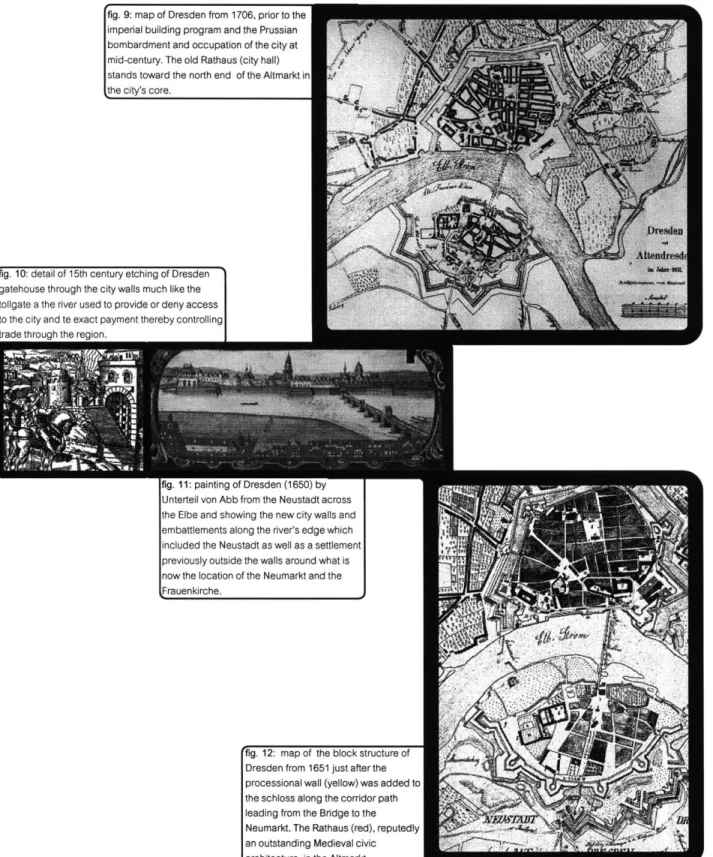
fig. 8: image from 1570 showing the bridg across the Elbe joining the walled Alten
nrpsdan (rinhti and the Neustadt (Ift)_
to be known as the Neumarkt within which resided the
Frauenkirche. This site which housed an even earlier church is thought to have been the location of a settlement existing earlier than that which came to be known as the Neustadt. This part of Dresden was later incorporated within the city, as was the Neustadt, with the erection of newer larger walls around the settlements in the late sixteenth century.
In the middle of the seveenteenth century, much of the city was destroyed, having been occupied by the Prussians. It was shortly thereafter that the city embarked upon a very ambitious building programe that saw the erection of a number of important Baroque edifices along or near the southern bank of the Elbe, the Zwinger most notably, establishing a monu-mental face as an entrance into the city from from the river. From its multiple origins around the bend in the Elbe, Dresden had remade itself from a provincial trading outpost into a symbol of magnificence for all of Saxony.
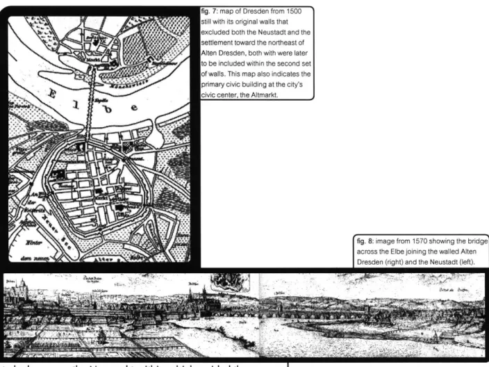
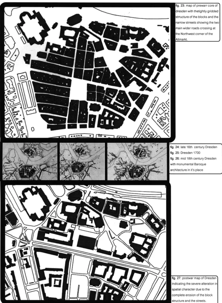
fig. 9: map of Dresden from 1706, prior to the imperial building program and the Prussian
bombardment and occupation of the city at mid-century. The old Rathaus (city hall) stands toward the north end of the Altmarkt in the city's core.
fig. 10: detail of 15th century etching of Dresden gatehouse through the city walls much like the tollgate a the river used to provide or deny access to the city and te exact payment thereby controlling
trngi= thrni tnh th= reninn
rig. ii: painung or uresaen kIb0U) Dy
Unterteil von Abb from the Neustadt across the Elbe and showing the new city walls and embattlements along the river's edge which included the Neustadt as well as a settlement previously outside the walls around what is now the location of the Neumarkt and the Frauenkirche.
fig. 12: map of the block structure of Dresden from 1651 just after the processional wall (yellow) was added to the schloss along the corridor path leading from the Bridge to the
Neumarkt. The Rathaus (red), reputedly an outstanding Medieval civic architecture, in the Altmarkt.
ig. 13: 1813 map of
Dresden Neustadt
and Alten Dresden ust after the end of he French
>ccupation and the
-emoval of the walls around the city core.
Shown is the figure
)round of the city, ncluding the 3aroque architecture along
:he water's edge ncluding the Kwinger (1), the 3opienkirche (2), and the :rauenkirche. This aarly nineteenth :entury map
aredates
the railroad and the extensive-hanges wrought on
:he city as a result of
-apid
industrializa-ion.
n9ig. q:; inis i uo
map of the Elbe's south bank shows the Schloss (center) prior to the erection of the Sophienkirche
(1), the Zwinger (2),
and the
'fig. 15: Painting by court painter from Italy, Benardo Belotto, of the bridge leading into Alten Dresden; Sophienkirche in the foreground, the Frauenkirche in the background.
'fig. 16: A composite map of Dresden past and
present showing development of the core of the city. The basemap represents the blocks and buildings before the firebombing with various shaded areas superimposed to indicate the changing shape and confiuration of the city. The small irregularly curving area represents the original walls and city core; the blue areasrepresent the location of the second generation of defensive walls, and the greyed areas represent the buildings, both newly and re-constructed, that have been built in the place of the ,old core since 1945.
fig. 17: The Sophienkirche, represented
under construction (left) and the Frauenkirche (right), both built during the first half of the 18th century and here shown as details from paintings by Bernardo Belotto, were part of a whole series of Baroque buildings and constructions that helped transform the city into a treasure trove of art and architecture and solidifv it as
ng. la: uresaen, 1 (bu, immeiately after the Prussian bombardment of the city with the resulting destruction (shown above) in black, including the Kreuzekirche (red).
The nineteenth and twentieth centuries were also as
thor-Dughly transformative as previous times in Dresden's history. With the rapid industrialization and growth that eventually took place in the last century and the early part of this one which brought, perhaps most significantly, the railrood through the city, it became something else yet again. Clearly, however, no one single time changed the physical reality as much as World War 11 and the firebombing of Dresden's inner core. It was an event that completely eradicated what had been known as Dresden up until then. The history and traces of the past still live on in the new city built upon the soil of the old, both in the newly constructed and recon-structed buildings as well as in the collective memory of its past. It does not disappear, but intead layer upon layer accumulates, fragment upon fragment, trace upon trace. All evidgnce may disappear and remain invisible, but absence still marks the surface.
fig. 19: a map of prewarr Dresde' core before the bombing by the B~ritish and American warplanes.
THE ALTMARKT SITE
The Altmarkt lies in the center of the city's core and is the historical heart and essence of its existence. From Dresden's inception as a post constructed to defend economic, political and geographic interests, it marked the center of a certain power asserted onto the landscape and its inhabitants. It was an ideological space that marked and controlled a river crossing and a crossroads. It is here in the middle of the city's core that is the target site of this project.
By initiating the rebuilding of many of the city's
cherished baroque, ninetheenth century, and medieval buildings, as well as through its reorganization of the city's spatial make-up, the DDR struggled to monumentalize its approach to history in order to naturalize its ideological connection to it. As such, the state was able to not only to
walls around Alten Dresden, Dresden Neustadt, and the settlement beyond the walls to the Northeast.
fig. 21: 15th century map of ddresden showing the
Rathaus in the center at the Altmarkt.
fig. 22: 16th centry map with second set of walls
around Alten Dresden, the Neustadt and expanded to contain the Neumarkt.
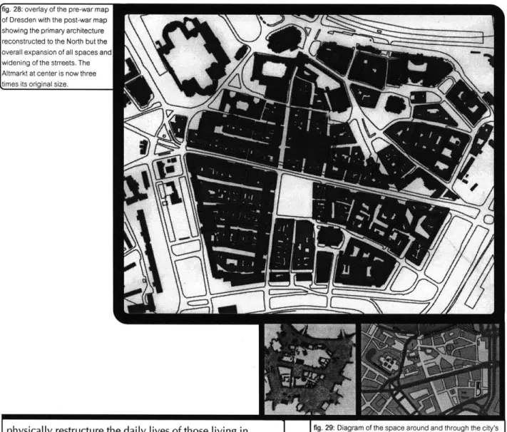
g. 23: map of prewarr core of
resden with thetightly gridded trructure of the blocks and the arrow strreets showing the two
lain wider roads crossing at
ie Northwest corner of the itmarkt.
fig. 24: late 16th century Dresden fig. 25: Dresden 1700
fig. 26: mid 18th century Dresden
with monumental Baroque architecture in it's place
fig. 27: postwar map of Dresden
indicating the severe alteration in spatial character due to the complete erosion of the block structure and the streets.
9MA
fig. 28: overlay of the pre-war map
of Dresden with the post-war map showing the primary architecture reconstructed to the North but the overall expansion of all spaces and widening of the strreets. The Altmarkt at center is now three times its original size.
physically restructure the daily lives of those living in Dresden and their relationship to its physical existence, but also to affect and invoke a new notion of space as infinite and flowing. Architecture existed within it, no longer defining it. Its radical re-shaping of the city-s infrastructure around the automobile and the rapid construction of quick and cheap housing for those who had been left homeless by the war and the bombing left little of the original spatial character of the old city core in tact.
The emphasis had shifted from urban spaces to more sub-urban experiences; from the pedestrian to the car, from spatial sequence to movement through space. It became an ad-hoc agglomeration of incomplete housing schemes. Wherever the newly planned architectural,
fig. 29: Diagram of the space around and through the city's
core, demonstrating the extreme expansion of the
spacearound the core that had been where the second set 01 city walls before they were destroyed at the turn of the 19th century, and which now are large highways.
fig. 30: Diagram of the city core showing the primary
automobile circulation (in red) around the core and through the widened Willsdruffer Strasse.
fig. 31: Aerial photograpf of the city's core and the
Altmarkt. The North-South axis is clear, running from top to bottom. Here, the Altmarkt is shown being used as a parking lot and prior to the construction of buildings marking the edge at the south of the market. Very little block structure and street edge can be discerned.
ig. jz: i ne pnmary axes sTii exist as in 1ne
:ity's historical core, but now widely
ixpanded spatially, especially the east-vest Willsdruffer Strasse, the crossroads
hat lie to the Northwest of the Altmarkt.
fig. 33: Here"' a photograph of the North-West axes from teh southwest of the Altmarkt with a new building being constructed and which begins to confine space in the street and market by defining a clear edge, not a popular or common modernist technique.
fig. 34: The Altmarkt shown above, three times the size of the original central space, with it's market active. The reconstructed
Kreuzekirche lies in the center, and the Rathaus to the right in the hoto
much less defined and abstracted version of what had existed prior to the bombing. Attention shifted, partly of necessity, to a more generalized and thereby abstraced notion of collective provision, and away from the specific individual experience. As such, the Altmarkt is remade into a much more monumen-tal space for mass demonstration instead of a smaller place for religious, commercial, and civic activity. The state sought to construct an entirely new architectural and spatial experience that, like its North American counterpart alienated the individual in the name of providing for his/her needs.
Redevelopment in Dresden in the re-unified GermanRepublic in the 1990's continues on some of the moves begun by the previous regime, namely by continuing the reconstruction of the monuments of the past and initiating
ig oo: sire-map wiin ne mitmarKi in ie center.
additional reconstructions. Moreover,
like
the previous attemptDto completely remake Dresden anew, this new regime's own building programme proposes and attempts to remake the city but this time by (re)covereing the past. The attempt is twofold: first, by utilizing New Urbanist planning techniques that recover the past's tradional building and spatial strategies in a renewed commitment to spatial definition for the individual experience; second, by (re)covering the recent modernist socialist architecture and planning, and thereby obscuring the past once again, but this time not in the clothes of something new and revolutionary. Rather, its presentation of itself, as are its strategies, is also covered by tradition and on the past. Such attempts, thus similiarly alienate the occupants from history and the past.
Embarking on a programme of infil, the modernist spatial and architectural ethos is concealed and, morreover, bolstered by a predominance of architectural references to
fig. 36: facing top:
Looking east along Wilsdruffer Strasse toward the Kulturpalasz
fig. 37: facing bottom:
Looking northwest across Wilsdruffer Strasse from the northeast corner of the Altmarkt.
fig. 38: top left: Looking
east across the
... ... ... A ltm arkt.
fig. 39: top right:
Looking southeast across the Altmarkt
toward the
Kreuzekirche.
fig. 40: bottom left:
Looking south along th east side of the Altmarkt.
fig. 41: bottom right:
Looking south along the west side of the Altmarkt.
fig. 42: siteplan of the project/intervention with the fig. 43: siteplan with a disassembled
configura-screen apparati arranged around the central tion of the apparati no longer addressing the
(re)covered excavation. excavation in the center or self-consciously
addressing themselves in the arrangement as a
coherent spatial edge.
fig. 44: East-West site-section through the Altmarkt showing the
I IV. qjj#. CLdZIVVUZL ZI..LUI I UI UI IV OPPC31OL CIU L LI IV VUY UI ilIV
excavation with its stair ascending to the second level and th
mechanized mobilization system below grade. I
I
THE FINAL PROJECTstyles of t e past centuries. is istorica a lienation, furt er-more, is twofold: The programatic functions of building develop-ments newly constructed and proposed for the city's core are overwhelmingly commercial and corporate. Owing to a reduc-tion in populareduc-tion, and motivated to pursue develoopment in the
pursuit of residents and especially capital, the large majority of new development concerns itself primarily with the retail industry, tourism, or commerce. Rather than the traditional mix of residential, accompanied by the requisite retail and services, and commerce supported by industry, the newly ocnfigured and
proposed core operates primarily as a tool to generate capital for remote corporate interests.
Viewed from this perspective, the newly refilled core is i hollow shell and the historicised archicture and and spatial
fig. 45: exterior facade of single apparatus showing large L.E.D. screen and smaller ionized glass projection screens belnw.
agendas as images to sell the past. The monuments ' reconstructed with the darkened and weathered original stones and masonry as well as pristine unweathered units, instead of representing a complicated aproach to a more complete history (replete with its destructive goals), dutifully serves to authenticate this new version of history, semingly to seamlessly connect past to present. This, like the previous epoch, in these great buildings,architecture, and urban planning of the present are monumentalized to represent the past.
Within the core of my proposal for a project in this site at the heart of the city of Dresden lives a similar urge to monumenalize, and thereby to edify and
Iig.
46: view of exterior L.E.D. screen, smaller ionized glassprojection screens, and dimly, the interactive computer screens inside the second level.
fig. 47: oblique
exterior view of L.E.C screen, smaller ionized glass projection screens, and stair to second level.
to (re)cover the past with architecture and planning of the present by architecturally, programmatically, and symbolically redefining Dresden's central open space, the Altmarkt.
Like all previous architectural reconstructions and restorations, the primary and most permanent architectural motive of the project is the desire to recover a piece of history, here in the form of the original Rathaus (home of the Medieval civic institu-tions) in the Altmarkt. Reported to have been a fine example of Medieval non-ecclesiastical architecture, the ruins of this structure (having once been part of an
fig. 50: view of interior glass facade with large
L.E.D. screen just inside and staircase to second
level to the left.
archeological investigation) is covered over beneath the surface of the market space.
The heart of this project, therefore, would be to recover these ruins. But in order to avoid and criticize the 'official' appropriation of these ruins and in order to resist iconographic exploitation of them on the scale of the Zwinger ro the Frauenkirche by the current and successive regimes, once the ruins were re-excavated and recovered, they would once again be re-covered with a new ground surface. Unlike a conventional earthen burial, capped by a symbolic and descriptive marker with a continuous spatial, textual, symbolic-,
fig. 51: interior facade I
relationship with the present, this site would remain unmarked, partially in order to aviod any romantic or nationalistic associa-tion with some mythic past a la Wagner.
Above ground, and surrounding this burial site on three sides is a series of apparati used, in part, to view ruins that now lie below grade and obscured by a layer of concrete. defining the edges of the ap, these apparati also define a new central space of the city, a space within a space, an object within an object, as this core space had once been as a walled medieval city in the landscape with its central open space. They screen this new space from the rest of now much larger space of the Altmarkt, and really all of surburbanized Dresden, by allowing passage ,below and sightlines through.
new monument retuses any tacile reassurance that the present space bears any affirmative relationship to history. It assures us only of history's destruction and disappearance, denying any iconographic exploitation for our own peace of mind. The ruins themselves cannot be exploited for their reality and truth as all that is present are images.
Although they may be shown with the objective "eye" of the surveillance camera, no one may bear witness. They merely state and it is with this statement that we become aware of the real power of these images. It is not for their iconic value, their symbolic value which may be used to affirm the verity and validity of history, for we are made acutely aware here that history is a conglomeration of such images of the past somehow ,unified into a single vision. Rather, it becomes clear to us that th
tig. b4: intenor tacace J
past, to act out a blasphemy of the sacred. The moment we observe or commemorate the history here, is that moment "His-tory" is soiled and tarnished.
This space of daily life is a monument to history in the very instant it denies its own monumentality. Any romantic reassurance in some idyllic pre-fascist era as thes ruins may seen to promise is now made even more remot by the knowledge that "History" always belongs to someone. Disassembled, however, the space becomes less coherent an object and begins to decom-pose. Once an object in itself, the space itself now begins to compose objects, where it was once composed, as the apparati separate themselves from the allignment and assert tehir own individuality as objects. Intended partly as shelters and anchors for vendors, each apparatus extends over a large area to offer
I-Foom for various vendors and and activities beneath. In addition to providing a covered outdoor space, for marketing purposes they may be moved by the vendors beneath to any spot along its track to some ideally suited location in the Altmarkt. Moreover, each apparatus is supplied with four smaller video projection screens to be used for advertising purposes both by the vendors and to be sold to other busi-ness and services throughout Dresden. Alongside and slightly below the images of the ruins, therefore, willb e the images >f commerce.
The third programmatic function of teh apparatus is Tiore didactic in nature. Due to the growing tourist interests n Dresden since reunification, and teh retail and commerce hat serve, advocate, and promote its growth, each apparatus
may serve as part of a tourist center to educate and offer information to tourists of Dresden's architectural and artistic heritage. On platforms twenty feet above ground
level which provide the shelter to the vendors below, each apparatus is to be furnished with an additional large L.E.D. screen. On these screens, however, the various architec-tural attractions of the area would be displayed inwards on the opposite facace of the apparati as a sort of virtual tour of Dresden. If further historical or cultural information were required or desired, additional desktop computer-sized interactive screens would be available on each
platform accessible by a stair attached to each apparatus. When alligned, a singular linear virtual tour passage from apparatus exists around the central (re)covered excavation.
On one face lies a service to tourists meant to be followed and affirmed by visits to the actual site of historical, architectural and artistic interest and further backed-up with historical data and information; and on the other face lie the silent ruins surmounting the more colorful, active, attractive and engaging smaller screens fo advertisements: history and commerece on one side, entertainment and education on the other. On the inside lies the verifiable and legitimated past, the "history of the victors" as Benjamin would note, and on the outside lies the image which only promotes itself and its own proliferation, the images of the ruins and of commerce.
Amid this spectacle of images wander the city's inhabit ants and tourists alike, one moment segregated and the next intermingling in the open market space. At any time one may
view the other among the images and realities of history and commerce. The daily life of the inhabitants mixes here with the consumption of the tourists. Time passes, days progress, and the present retreats into the past becoming history. All that
remains constant really are the memories and the traces of the past in our minds. The passage of time is only evident upon the changing objects and people, what it means and represents
however lies only in our collective knowledge and conscious-ness of the past. The only mistake of this knowledge is believ-ing that it contains all experience, every history.
.8
6
fig. 61
view from south east
*
lookingDaniel Libeskind has something interesting to offer on this subject of the invisible.
I think one should not be too impressed by what is called 'physical space.'
Physical space is good for physics: it's not an architectural space and it is interesting that most architects still talk about architecture as if it were grounded in physics-not just Euclidean physics but also physics of the building. It's clear that a building is not made out of glass and bricks-but is constituted by something else. It might be grounded on these
ig. 67: interior view looking
down alligned passage from
one
apparati to the next,reating a virtual tour.
figs. 68: images of
hyical model.
hierarchies of material reality but that would be to say that human beings were based on fish or protozoa; of course they are but there is a difference between foundation and formation.
And the foundation and meaning of architecture and space is not merely upon some image of the past or of commerce, the exploitation or consumption of that image, but upon ALL those who occupy it. Moreover, it is also the recognition that to construct architecture and space, as history, is always todesecrate it, to fragment it and all of those to whom it belongs.
Bibliography
Loeffler, Fritz. Bernardo Bellotto gennant Canaletto: Dresden W 18 Jahrhrdet; Koehler & Anelay,
Leipzig.
Papri, Eva. Festung Dresden. Ans der Geschichte der Dresdner Stadtbifestiguay, 1997.
Figure Credits
1 Illumination zu Ehren Napoleons und des Kaisers Franz 11. am 18, Mai 1813, aquarelle. Stadtmuseum Dresden 2 Dresden um 1200, eine regelmabige Anlage mit einfachem Mauerring, Rekonstructions zeichnung von 0. Trautmann, 1916
0. Trautmann, Der Boden Dresdens vor 700 Jahren, in Dresdner Geschichtsblatter 1916/3. 3.Situation Dresden vor 1519
Sachsisches Hauptstaatsarchiv, Hansen Beiers abris der Stadt Dresden, Loc. 4451. 4 Dresden 1270, Rekonstruktionszeichnung von R. Spehr, 1990
Das Dresdener Schloss, Monument sachsischer Geschichte un Kultur, Dresden 1990.
5 Burgerliche Frau aus Dresden, nach 1500 Kupferstich aus dem Dresdner Totentanz A. Wech, Der
Chur=Furstlichen Sachsischen weitberuffenen REsidentz=und Haupt+Vestung Dresden Beschreib: und Vorstellung, Nurnberg 1680.
6 Stadtansicht Dresdens vor 1519, Blick von Suden, kolorierte Zeichnung nach einem Holzmodell von 1521
Stadtmuseum Dresden.
7 Stadtgrundriss von Dresden um 1500 Sachsischer Schulatlas von Lang-Diercke. Anfang 20, Jahrhundert. 8 Ansicht von Dresden, von Osten gesehen, Federzeichnung von Gabrielle Tola, 1570 Stadtmuseum Desden. 9 Friedrich August Graf von Rutkowsky, Kupferstich von Chr. Sysang
Militarhisorisches Museum der Bundeswehr, Dresden.
10 Vor einer'belagerten Stadt, Stadttor mit Fallgater und Zugbrucke, Kupferstich, 16. Jahrhundert.
L. Fronsperger, Kriegsbuch, 3. Teil, 1573.
11 Dresden vom Altendresdner Ufer, Gemalde um 1650, Unterteil von Abb. 90.
Statliche Kunstammlungen Dresden, Rustkammer.
12 Dresden und Altendresden mit den Befestigungen von 1634, den grossen Bastionen Dilichs um Altendresden undder Feldbefestigung um die Residenz, Plan von Samuel Nienborg, 1651. Sachsiches Hauptstaatsarchiv.
13 Dresden 1813 mit den Napoleonischen Feldbefestigunge, Kopie einer Handzeichnung von H. Aster 0. Richter, Atlas zur Gerschichte Dresdens, Dresden 1898.
14 Heinrich Graf Bruhl, Kupferstich von Lorenzo Zucchi. Staatliche Kunstsammlungen Dresden, Kupferstich-Kabinett.
15 Bernardo Bellotto gennant Canaletto, 1758
'6 Wasserlaufe und Hochwassergrenzen in und um Dresden, Plan von Chr. Adam, 1958
Arbeits-und Forschungsbericht zur Sachsischen Bodendenkmalpflege des Landesamtes fur Archaologie Dresden, Bd. 3;7, 1995, S. 205-209.
'7 Bernardo Bellotto Gennant Canaletto, 1758.
18 Dresden 1760, mit den Feldbefestigungen um die Stadt, mit Angabe der Zerstorungen 1758/59 sowie der
preusischen Beschiessung nach einer Handzeichnung.