HAL Id: tel-02474315
https://tel.archives-ouvertes.fr/tel-02474315v2
Submitted on 11 Feb 2020HAL is a multi-disciplinary open access archive for the deposit and dissemination of sci-entific research documents, whether they are pub-lished or not. The documents may come from teaching and research institutions in France or abroad, or from public or private research centers.
L’archive ouverte pluridisciplinaire HAL, est destinée au dépôt et à la diffusion de documents scientifiques de niveau recherche, publiés ou non, émanant des établissements d’enseignement et de recherche français ou étrangers, des laboratoires publics ou privés.
and embedded GPS and its application in dike
monitoring
Yilin Zhou
To cite this version:
Yilin Zhou. 100% automatic metrology with UAV photogrammetry and embedded GPS and its application in dike monitoring. Geophysics [physics.geo-ph]. Université Paris-Est, 2019. English. �NNT : 2019PESC2033�. �tel-02474315v2�
Universit´e Paris-Est
´
Ecole Doctorale MSTIC
Math´ematiques & Sciences et Technologies
de l’Information et de la Communication
Sp´ecialit´e: Sciences et Technologies de l’Information G´eographiqueTH`
ESE DE DOCTORAT
En vue de l’obtention du grade de :
Docteur de l’Universit´e Paris-Est
pr´esent´ee et soutenue le 6 D´ecembre 2019 par :
Yilin Zhou
M´etrologie 100% automatique par photogramm´etrie a´eroport´ee
l´eg`ere et GPS de pr´ecision permanent et embarqu´e, application
au suivi de digues
Composition du jury :
Directeur de th`ese: Marc Pierrot-Deseilligny IGN-ENSG
Rapporteur: Pierre Grussenmeyer INSA Strasbourg
Rapporteur: Peter Sturm INRIA Grenoble Rhˆone-Alpes
Examinateur: Francesco Nex University of Twente
Examinatrice: Marie-Odile Berger INRIA Nancy Grand Est
Pr´esident du jury: Pascal Monasse ENPC
Encadrante: Ewelina Rupnik IGN-ENSG
Paris-Est University
MSTIC Doctoral School
Mathematics & Sciences and Technologies
of Information and Communication
Domain: Sciences and Technologies of Geographical Information
Ph.D Thesis
To obtain the grade of :Doctorate of Paris-Est University
presented and defended on 6th December 2019 by :
Yilin Zhou
100% automatic metrology with UAV photogrammetry and
embedded GPS, and its application in dike monitoring
Composition of the jury :
Supervisor: Marc Pierrot-Deseilligny IGN-ENSG
Reviewer: Pierre Grussenmeyer INSA Strasbourg
Reviewer: Peter Sturm INRIA Grenoble Rhˆone-Alpes
Examiner: Francesco Nex University of Twente
Examiner: Marie-Odile Berger INRIA Nancy Grand Est
President of jury: Pascal Monasse ENPC
Co-supervisor: Ewelina Rupnik IGN-ENSG
R´ESUM´E
Le d´eveloppement des plateformes de v´ehicules a´eriens autonomes (UAV) en fait une source de donn´ees pr´ecieuse pour les applications d’inspection, de suivi, de car-tographie et de mod´elisation 3D. Le drone ouvre de nouvelles applications dans la photogramm´etrie a´erienne rapproch´ee et introduit une alternative peu coˆuteuse `a la photogramm´etrie classique pour v´ehicules pilot´es.
La cartographie de corridors, est l’un des domaines d’importance consid´erable pour la photogramm´etrie par drone, car largement sollicit´ee pour le suivi et la gestion de certaines infrastructures — les autoroutes, les voies ferroviaires, les voies navigables et les ol´eoducs. En raison de la g´eom´etrie particuli`ere de la sc`ene, ceci est un cas `a prendre avec pr´ecaution. Les erreurs s’accumulent facilement sur la plus longue dimen-sion de la sc`ene et une d´eformation en bol est souvent observ´ee; de plus, la plan´eit´e de la sc`ene introduit de fortes corr´elations entre les param`etres `a d´eterminer. Ces deux facteurs r´eunis rendent plus difficile l’obtention de r´esultats de haute pr´ecision dans la configuration corridor par rapport `a une g´eom´etrie de prise de vue plus classique.
Cette th`ese est un projet de recherche initi´e par la CNR, un concessionnaire fluvial, responsable de la maintenance et de la surveillance de ses ouvrages hydrauliques, et plus particuli`erement des digues. L’objectif est d’appliquer la photogramm´etrie par drone pour obtenir un suivi 3D dense, plus rapide et moins ch`ere, pour l’ausculation de ces digues. Dans le cadre de la th`ese, nous cherchons `a r´eduire le travail de terrain tout en maintenant une pr´ecision cartographique ´elev´ee, en l’occurence, diminuer le nombre de points de contrˆole au sol (GCP).
Dans un premier temps, des simulations sont r´ealis´ees pour mieux comprendre cer-tains probl`emes de cartographie de corridors qui impactent la pr´ecision finale. Ensuite, des ´etudes plus approfondies sont men´ees sur les trois aspects qui nous int´eressent le plus. Le premier porte sur la g´eom´etrie de l’acquisition a´erienne, et plus pr´ecis´ement sur l’influence des images obliques, des images nadir de diff´erentes hauteurs de vol, ainsi que la possibilit´e d’une calibration de cam´era en vol et son application `a une g´eom´etrie d’acquisition d´efavorable. Le deuxi`eme vise `a am´eliorer les performances d’acquisition des cam´eras m´etriques haute gamme. La d´eformation de l’image introduite par la varia-tion de la temp´erature de la cam´era est ´etudi´ee et mod´elis´ee. Une m´ethode de correction de cet effet thermique est propos´ee, ses performances sont ´evalu´ees sur des jeux de don-n´ees terrestres et a´eriens en configuration de corridors. Le dernier s’int´eresse `a l’effet de l’obturateur roulant utilis´e dans les cam´eras grand public, qui est vu couramment sur les plateformes UAV du march´e. Deux m´ethodes sont pr´esent´ees pour calibrer le temps de lecture de la cam´era, une propri´et´e qui n’est souvent pas donn´ee par les fabricants de cam´eras. Une m´ethode en deux ´etapes est propos´ee pour la correction de l’effet de l’obturateur roulant, ses performances sont ´evalu´ees dans les configurations de bloc et de corridor.
Mots clefs : UAV, suivi de digue, cartographie de corridors, g´eom´etrie d’acquisi-tion, effet thermique, obturateur roulant
ABSTRACT
The development of unmanned aerial vehicle (UAV) platform makes it nowadays a valuable source of data for inspection, surveillance, mapping and 3D modeling issues. UAV photogrammetry opens various new applications in close-range aerial domain and introduces a low-cost alternative to classical manned vehicle photogrammetry.
Corridor mapping, one of the fields with substantial importance for UAV photo-grammetry, is largely demanded in the surveillance and management of infrastructure assets – highways, railways, waterways and pipelines. Due to the special geometry of the scene, corridor mapping is one case that needs taking precautions. Errors accumu-late easily on the longer dimension of the scene and a bowl effect is often observed; the flatness of the scene introduces strong correlations between parameters to be determi-ned, these two factors together, make it more difficult to obtain high accuracy results in corridor configuration than in classical ones.
This thesis is a research project initiated by the CNR, a river concessionary, which has the responsibility of the maintenance and surveillance of its hydraulic facilities, more particularly the dikes. The objective is to apply UAV photogrammetry, which is faster, cheaper and offers a 3D dense reconstruction of the scene, to the monitoring of dikes. While maintaining a high surveying accuracy, a reduced field work, i.e. the number of ground control points (GCPs) is expected.
In the first place, simulations are carried out to gain an insight of several problems of corridor mapping that impact the final accuracy. Then, thorough investigations are conducted on three aspects that interest us the most. The first study focuses on the aerial acquisition geometry, discussions are given on the influence of oblique images, nadir images of different flight heights as well as the possibility of an in-flight camera calibration and its application on unfavourable acquisition geometry. The second study aims to improve the acquisition performance for high-end metric cameras. The image deformation introduced by camera temperature variation is investigated and modelled. A method for the correction of this thermal effect is proposed, its performance is eva-luated on both terrestrial and aerial datasets of corridor configuration. The last study interests in the rolling shutter effect for consumer-grade cameras, which is commonly seen in UAV platforms on the market. Two methods are presented to calibrate the camera readout time, a property that is often not given by camera manufacturers. A two-step method is proposed for the correction of rolling shutter effect, its performance is evaluated in both block and corridor configurations.
Keywords : UAV, dike monitoring, corridor mapping, acquisition geometry, ther-mal effect, rolling shutter
Acknowledgements
Three years of PhD life have passed in the blink of an eye and here I find myself at the end of the journey. I will always cherish the three years I spent here. Not only because it has been a wonderful experience I shared with great people, but also because it taught me that the world is interesting and fascinating when you stay open-minded and curious.
I consider myself fortunate to have had the opportunity to do research and pursue a PhD. I will never take for granted the support, inspiration, and guidance I’ve received, in a country that is 10000 km away from my home in China, by a bunch of people that come from different cultures and speak different languages than me. Thanks to them, I have never been homesick, except when my stomach fancies Chinese food.
My gratitude first goes to my thesis supervisor, Marc Pierrot-Deseilligny, without whom my thesis would never have been accomplished. Under his supervision, I have learned not only how to work, but also how to be humble and indulgent. I would like to thank him for having given me time to make mistakes, to learn and to progress.
I would also like to thank my industrial supervisor, Paul-Henri Faure, for the finan-cial and operational supports he provided me, on behalf of the Compagnie Nationale du Rhˆone (CNR).
To the MicMac team with whom I spent three years, I am incredibly happy and thankful. My sincere thanks goes to Ewelina Rupnik, for being a wonderful supervisor, a friend from whom I learned a lot, not to mention all the fines she had for being the prime driver on the way to data acquisitions. To Mehdi Daakir, for being an impeccable friend in both my work and personal lives. He spent countless weekends with me, helping with data processing and writing; he also picked me up when I locked myself out of my apartment. To Giang Nguyen, for all the joy he brought to me with his unintentional humor and his endless creativity. The only way I can possibly thank each of them is through a long-lasting friendship.
My gratitude also extends to all my colleagues from LOEMI, with whom I have always felt like a spoiled child. To Christian Thom, for sharing his wisdon whenever I came to him with problems, and for sharing his insight and understanding of quantum physics. To Christophe Meynard, for unreservedly providing me with help, for sharing with me his passion for the sci-fi novel The Three-Body Problem and for suffering through a 20-hour drive with me in a car without air conditioning. To Olivier Martin, for all the technical and instrumental support, for being a great friend with whom I play badmintion, go to market, share tea time, and joke around with. I am sure he will be the best father for his daughter Rose. To Jean-Philippe Souchon, for showing me his great passion about music which encouraged me to pursue my own passion, and for sharing with me the life of his guinea pig. To Jean Michael M¨uller, for his wisdom, for always providing me help, and for buying me the fabulous movie poster from Good Morning England.
I would like to express my appreciation to all the fellows of the research team: Jonathan Lisein, Imane Fikri, Lulin Zhang, Mohamed Amjad Lasri, Ahmad Audi, Evelyn Paiz, Raphael Sulzer, Qasem Safari, Stephane Guinard, Oussama Ennafii,
Na-moments we shared together. I would like to acknowledge my colleagues from ENSG: Antoine Pinte, Marc Poup´ee, Jean-Fran¸cois Hangou¨et, Patricia Pellardi, Jean-Pierre Papelard, Serge Botton, Jacques Beilin, for the help they provided during my thesis. I would like to thank my colleagues from team TS at IGN: Laurent Heydel, Paul Bou-quet, Fabien Bergerault and Sylvain Gonnet, for their participation in data acquisition and processing. I would like to acknowledge the staff of Universit´e Paris-Est: Sylvie Cach and Fatima de Freitas, for their help on administration procedures.
A special gratitude goes to Cl´ement Bouch´e, for always being understanding and supportive. Your one-of-a-kind humor and jokes added an irreplaceable flavour to my PhD student life.
Last but not the least, I would like to thank my parents for always being there for me and for always letting me pursue my dreams. Confucius said, “whilst thy father and mother are living, do not wander afar. If thou must travel, hold a set course.” I hope to live up to their expectations and to never worry them.
Compagnie Nationale du Rhˆone (CNR) Direction du Port de Lyon
1, rue de Chalon-sur-Saˆone 69007 Lyon
France
Institut National de l’Information G´eographique et Foresti`ere (IGN) 73 avenue de Paris
94165 SAINT-MAND´E
France
Ecole Nationale des Sciences G´eographiques (ENSG) 6-8 Avenue Blaise Pascal
Cit´e Descartes Champs-sur-Marne 77455 Marne la Vall´ee France
Table of contents
Table of contents
1 Introduction en fran¸cais 1
1.1 Contexte . . . 1 1.1.1 IGN . . . 2 1.1.2 CNR . . . 2 1.1.3 Surveillance de digue . . . 3 1.2 Besoins et attentes . . . 4 1.3 Organisation et contributions . . . 6 2 Introduction 9 2.1 Context . . . 9 2.1.1 IGN . . . 10 2.1.2 CNR . . . 10 2.1.3 Dike surveillance . . . 10
2.2 Needs and expectations . . . 12
2.3 Organization and contributions . . . 14
3 State of the art 17 3.1 UAV plateforms . . . 17
3.1.1 GNSS . . . 18
3.1.2 IMU . . . 19
3.2 UAV Photogrammetry . . . 20
3.3 Photogrammetry Processing . . . 20
3.3.1 Interior orientation . . . 21
3.3.2 Exterior orientation . . . 21
3.3.3 Bundle block adjustment (BBA). . . 23
3.4 Corridor mapping . . . 24
3.5 Hardware . . . 25
3.5.1 Off-the-shelf UAV platforms . . . 25
3.5.2 IGN lightweight metric camera . . . 25
3.5.3 IGN GeoCube . . . 26
3.6 Software . . . 27
3.6.1 MicMac . . . 27
3.6.2 RTKLib . . . 28
4 Simulation and analysis 31 4.1 Introduction . . . 32
4.2 Data generation and research design . . . 33
4.2.1 Generation of a synthetic dataset . . . 33
4.2.2 Problem simulation and result evaluation . . . 34
4.3 Experiments and results . . . 35
4.3.1 Erroneous focal length . . . 35
4.3.2 Gradually varied focal length . . . 36
4.3.3 Error coming from rolling shutter effect . . . 37
4.4 Conclusion and Discussion . . . 42
5 Study of aerial acquisition geometry 43 5.1 Introduction . . . 44
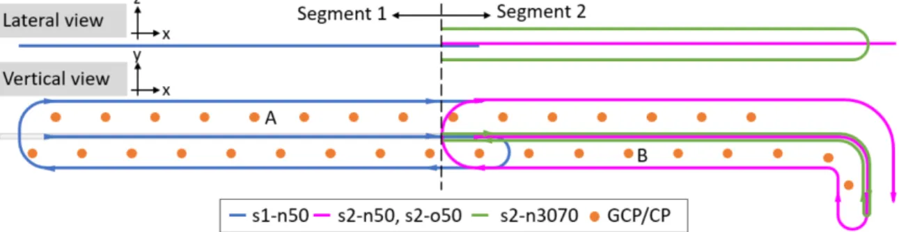
TABLE OF CONTENTS 5.3 System design . . . 46 5.3.1 UAV . . . 46 5.3.2 Camera . . . 47 5.3.3 GNSS module . . . 47 5.4 Methodology . . . 47 5.5 Data acquisition . . . 49 5.5.1 Acquisition field . . . 49 5.5.2 Flight design . . . 50 5.6 Data processing . . . 51
5.6.1 Topographic data processing . . . 51
5.6.2 GNSS data processing . . . 51
5.6.3 Synchronization of GNSS and camera modules . . . 51
5.6.4 Photogrammetric data processing . . . 52
5.7 Results . . . 53
5.7.1 Influence of oblique images . . . 56
5.7.2 Influence of multiple flight heights . . . 56
5.7.3 Basic flight configuration . . . 56
5.8 Discussion . . . 57
6 Study of thermal effect 59 6.1 Introduction . . . 60
6.2 State of the art . . . 60
6.3 IGN lightweight metric camera . . . 61
6.3.1 Generalities . . . 62
6.3.2 Temperature registration . . . 62
6.4 Calibration of thermal effect . . . 63
6.4.1 Thermal model . . . 63
6.4.3 Deformation determination with bundle adjustment . . . 69 6.5 Experimental evaluation . . . 71 6.5.1 Terrestrial acquisition . . . 71 6.5.2 Aerial acquisition . . . 75 6.6 Conclusion . . . 78 6.7 Further Work . . . 79
7 Study of rolling shutter effect 81 7.1 Introduction . . . 82
7.2 State of the art . . . 83
7.3 Problem formulation . . . 83
7.4 System and calibration . . . 84
7.4.1 Drone and camera . . . 84
7.4.2 Calibration of readout time . . . 85
7.5 Research design . . . 90
7.6 Experiments and results . . . 93
7.6.1 Introduction of datasets . . . 93
7.6.2 Camera calibration model . . . 94
7.6.3 Data processing . . . 95
7.6.4 Results . . . 96
7.7 Conclusion and perspective. . . 103
8 Conclusion and Perspective 107
A GNSS processing with RTKLib I
B An example of the RTKLib configuration file V
C Photogrammetric processing with MicMac IX
TABLE OF CONTENTS
C.2 Commands for special purposes . . . XV
D Acquisition report LP2017 XIX
D.1 Context and objective . . . XIX
D.2 UAV and embarked sensors . . . XX
D.3 Topographical landmarks . . . XX
D.4 Acquisition plan . . . XXI
D.5 Discussion . . . XXII
E Acquisition report Roche2018 XXV
E.1 Context and objective . . . XXV
E.2 UAV and embarked sensors . . . XXVI
E.3 Topological landmarks . . . XXVI
E.4 Acquisition plan . . . XXVII
F Acquisition report LP2018 XXIX
F.1 Context and objective . . . XXIX
F.2 UAV and embarked sensors . . . XXX
F.3 Topographical landmarks . . . XXX
F.4 Acquisition plan . . . XXXI
G Supplementary results XXXIII
G.1 Simulation of Gaussian noise on tie points . . . XXXIII
Table des figures XLV
Chapter 1
Introduction en fran¸
cais
Contents
1.1 Contexte. . . 1 1.1.1 IGN . . . 2 1.1.2 CNR . . . 2 1.1.3 Surveillance de digue . . . 3 1.2 Besoins et attentes. . . 4 1.3 Organisation et contributions . . . 61.1
Contexte
Selon la d´efinition d’UVS International, un drone (UAV) est un avion g´en´erique con¸cu pour fonctionner sans pilote humain `a bord (Remondino et al. [2011]). Dans le pass´e, le d´eveloppement de syst`emes et de plateformes UAV reposait principalement sur des objectifs militaires. De nos jours, les syst`emes UAV jouent un rˆole croissant dans le domaine de la g´eomatique. Le drone ouvre de nouvelles applications dans la photogramm´etrie a´erienne rapproch´ee et introduit une alternative peu coˆuteuse `a la photogramm´etrie a´erienne classique (Colomina and de la Tecnologia [2008]; Eisenbeiß [2009]).
La cartographie de corridor, largement utilis´ee pour le suivi et la gestion des infra-structures — les autoroutes, les voies ferroviaires, les voies navigables et les ol´eoducs, est l’un des domaines d’importance majeure pour la photogramm´etrie par drone. Ce travail de th`ese est un projet de recherche en partenariat entre l’Institut National de l’Information G´eographique et Foresti`ere (IGN) et la Compagnie Nationale du Rh^one (CNR). L’objectif est d’utiliser la cartographie de corridor pour r´ealiser le suivi des ouvrages hydrauliques de la CNR, et plus particuli`erement des digues.
Malgr´e le d´eveloppement rapide des plateformes UAV, des capteurs embarqu´es et des solutions logicielles de traitement de donn´ees, la cartographie de corridor reste dif-ficile `a cause de sa g´eom´etrie particuli`ere. Dans ce travail, la sc`ene d’int´erˆet est relev´ee `
eci-sion de la cartographie afin de d´etecter le plus pr´ecocement possible des mouvements signalant des d´efauts potentiels.
1.1.1
IGN
L’Institut National de l’Information G´eographique et Foresti`ere (IGN),
anciennement nomm´e Institut G´eographique National, est un ´etablissement pu-blic fran¸cais. Fond´e en 1940, il produit et g`ere des informations g´eographiques pour la France m´etropolitaine et ses d´epartements et territoires d’outre-mer. Il d´eveloppe en permanence de nouveaux produits et g´eo-services pour r´epondre aux besoins croissants et ´evolutifs de donn´ees cartographiques et d’informations g´eolocalis´ees. Grˆace aux UMR (Unit´e Mixte de Recherche) auquels l’institut participe, l’UMR LaSTIG (Laboratoire
en Sciences et Technologies de l’Information G´eographique), l’UMR IPGP (Institut
de Physique du Globe de Paris) et Lif (Laboratoire d’inventaire forestier), l’IGN maintient un haut potentiel d’innovation dans les domaines de la g´eod´esie, de la topographie vectorielle, du traitement d’images et de l’inventaire forestier.
Le travail de cette th`ese est r´ealis´e au sein de l’´equipe de recherche ACTE du la-boratoire LaSTIG. L’´equipe de recherche se concentre sur les m´ethodes et les outils permettant l’acquisition de donn´ees g´eor´ef´erenc´ees et structur´ees g´eom´etriquement. Ses activit´es de recherche consistent en :
• conception, production et calibration d’instruments m´etrologiques innovants ; • estimation fine de la pose et recherche d’images par le contenu ;
• mod´elisation du signal ´electromagn´etique pour une interpr´etation physique des images ;
• structuration g´eom´etrique et compr´ehension de la sc`ene.
1.1.2
CNR
La Compagnie Nationale du Rh^one (CNR) produit le quart de l’hydro´electricit´e fran¸caise et est le premier producteur fran¸cais d’´energie exclusivement renouvelable. En tant que concessionnaire du Rhˆone, la CNR g`ere la navigation sur le fleuve et agit quotidiennement pour assurer la maintenance et la s´ecurit´e de ses ´equipements. La CNR poss`ede notamment un patrimoine de 50 barrages, ´ecluses, centrales hydro´electriques et 400 km de digues.
Le laboratoire CACOH de la CNR est le garant de 80 ann´ees d’exp´erience dans le do-maine de l’hydro´electricit´e et du d´eveloppement des cours d’eau. Le CACOH se concentre maintenant sur la maˆıtrise des risques hydrauliques et l’optimisation du fonctionnement des structures. `A la pointe de la technologie, il contribue `a faire en sorte que la CNR soit en mesure de garantir le plus haut niveau de suret´e.
CHAPTER 1. INTRODUCTION EN FRAN ¸CAIS
1.1.3
Surveillance de digue
Les digues sont des structures hydrauliques artificelles qui r´egulent les niveaux d’eau. Elles sont sous l’influence continue des conditions m´et´eorologiques et des r´ e-gimes fluviaux variables. Il est donc tr`es important de surveiller la d´eformation et de localiser les zones vuln´erables pour un traitement en amont.
Pour cette ´etude, la digue de La Palli`ere de la CNR a ´et´e choisie comme site d’int´erˆet (cf. Figure.1.1). Cette digue est situ´ee sur le Rhˆone `a Culoz, France et a ´et´e construite dans les ann´ees 1980. Soumise `a des tassements depuis sa construction, cette portion de digue fait l’objet d’une surveillance sp´ecifique. Actuellement, la CNR utilise princi-palement trois proc´edures de surveillance des digues et de d´etection des d´efauts sur le site de La Palli`ere : la surveillance visuelle, la surveillance de la charge hydraulique interne et la surveillance altim´etrique.
Figure. 1.1 – Le site d’int´erˆet, La Palli`ere.
Surveillance visuelle Des techniciens effectuent une inspection visuelle `a la re-cherche de d´efauts visibles tels que des fuites, des affaissements ou tout signe d’avertis-sement. La surveillance visuelle est efficace pour d´etecter les signes visibles de d´efauts. C’est le premier niveau de d´etection.
Figure. 1.2 – Un profil transversal de la digue et l’installation de pi´ezom`etres. Source : rapport interne du CNR.
Surveillance de la charge hydraulique interne Les digues du Rhˆone ne sont
pas ´etanches et sont donc con¸cues pour subir continuellement une charge hydraulique. Des pi´ezom`etres sont install´es tous les 300 `a 500 m`etres sur les profils transversaux de la digue (Figure1.2). Les mesures pi´ezom´etriques permettent de suivre le rabattement hydraulique entre le Rhˆone et le canal de drainage. Cette auscultation permet de v´erifier le bon fonctionnement hydraulique de l’ouvrage.
Surveillance altim´etrique Outre les mesures pi´ezom´etriques, un r´eseau de r´ef´erence altim´etrique est install´e le long de la structure et r´eguli`erement examin´e par nivellement direct. La surveillance altim´etrique permet de suivre l’´evolution du profil de la structure avec une pr´ecision millim´etrique sur les points mesur´es. Un ´eventuel affaissement peut ˆ
etre identifi´e en comparant les profils mesur´es `a diff´erents moments.
1.2
Besoins et attentes
Le r´eseau de pi´ezom`etres et de r´ef´erences altim´etriques permet une surveillance de points identifi´es de la digue. Cependant, une surveillance globale ne peut ˆetre r´ eali-s´ee, un ´eventuel d´efaut entre deux points mesur´es peut ˆetre n´eglig´e. La CNR et l’IGN ´
etablissent donc un partenariat d´eveloppant des m´ethodes d’acquisition permettant un suivi 3D dense de la digue. `A cette fin, des acquisitions Lidar terrestres et a´eriennes ont ´et´e r´ealis´ees dans certaines zones. Un suivi 3D dense peut ˆetre r´ealis´ee, cependant, ce type d’acquisition reste coˆuteux (l’application sur une grande surface est limit´ee), fastidieux (stations multiples, temps d’acquisition important) et insatisfaisant sur la pr´ecision finale (pr´ecision d´ecim´etrique).
L’´erosion interne, premi`ere cause de rupture de digues, est l’int´erˆet central du pro-jet ERINOH (´erosion interne des ouvrages hydrauliques), lanc´e en 2006 et regroupant 75 organisations collaboratrices. Des tests sur des mod`eles physiques sont r´ealis´es au sein de CACOH (Beguin [2011]), l’´etude montre que certaines ´erosions internes peuvent provoquer des d´eformations `a la surface de la digue (cf. Figure.1.3). Un effondrement `
a petite ´echelle de plusieurs centim`etres peut ˆetre le signal d’une ´erosion interne. La d´etection de ces changements est donc importante pour la surveillance des digues et la pr´evention des risques.
CHAPTER 1. INTRODUCTION EN FRAN ¸CAIS
Figure. 1.3 – A et B : mod`ele physique dans lequel l’´erosion interne est simul´ee. C : comparaison de mod`eles 3D dans le cas d’un tassement. Source : rapport interne de la CNR,
Beguin[2011]; Tournadre[2015].
C’est ici que la photogramm´etrie a´erienne devient int´eressante. Les mod`eles de sur-face topographiques de haute pr´ecision et l’analyse diachronique permettent de d´etecter les d´efauts de la digue avant que des dommages graves ne se produisent. Dans le cadre de l’optimisation de ses m´ethodes de surveillance et d’auscultation, la CNR ´etudie depuis 2011 l’usage des drones et de la photogramm´etrie comme moyen compl´ementaire aux m´ethodes traditionnelles. Le drone en tant que vecteur offre de multiples avantages : les acquisitions peuvent ˆetre effectu´ees mˆeme sur des sites inaccessibles par voie terrestre, la dur´ee d’acquisition est plus courte, le coˆut d’acquisition est inf´erieur.
La CNR esp`ere obtenir comme r´esultat final un mod`ele de surface num´erique (DSM), sous la forme de nuage de points. Dans le cas d’une surveillance r´eguli`ere, une pr´ecision centim´etrique est attendue. En cas d’intervention `a la suite d’un ´ev´enement exception-nel, une pr´ecision de 3 cm est attendue (cf. Table. 1.1). Pour r´epondre `a ces attentes, la CNR et l’IGN ont collabor´e sur une premi`ere th`ese portant sur le suivi de digue par photogramm´etrie par drone. La th`ese Tournadre [2015], d´emarr´ee en 2012, avait uti-lis´e des cam´eras grand public non ´equip´ees de syst`eme GNSS embarqu´e. Cette th`ese avait mis au point un protocole d’acquisition et de traitement permettant d’arriver `a une pr´ecision centim´etrique avec un point d’appui tous les 100 m. Bien qu’il r´eponde aux attentes de la CNR, le besoin en densit´e de points d’appui reste une limitation forte pour le d´eploiement op´erationnel. L’objectif de la pr´esente th`ese est d’arriver `a la mˆeme pr´ecision avec peu ou pas de point d’appuis, en b´en´eficiant des progr`es du mat´eriel d’ac-quisition (cam´eras photogramm´etriques et syst`eme GNSS embarqu´e) et en optimisant les m´ethodes d’acquisition et de traitement. De nos jours, une reconstruction 3D dense peut ˆetre r´ealis´ee avec des solutions de pointe. Par cons´equent, l’accent de notre th`ese sera mis sur l’obtention des orientations int´erieure et ext´erieure de la cam´era d’une haute pr´ecision.
Type d’Acquisition Fr´equence d’Acquisition Longueur de Sc`ene Pr´ecision Attendue Besoin R´egulier 1 fois/an jusqu’`a 1 km 1 cm
D´etection de d´eformations
pour la surveillance d’une zone sensible bien d´efinie.
Exceptionnel si n´ecessaire plusieurs kilom`etres 3 cm Comparaison `a un ´etat initial apr`es un ´ev´enement exceptionnel. Table. 1.1 – Besoins et attentes de la CNR pour la surveillance de digues.
1.3
Organisation et contributions
Au cours de ce travail de th`ese, nous ´etudions trois m´ethodes qui am´eliorent la pr´ecision des mesures 3D dans des acquisitions photogramm´etriques a´eriennes pour une sc`ene de configuration corridor, tout en minimisant le nombre de points de contrˆole au sol.
Une br`eve pr´esentation de l’´etat de l’art est donn´ee dans le Chapitre3. La pr´ esen-tation couvre dans un premier temps les plateformes UAV et les syst`emes de navigation embarqu´es, la photogramm´etrie par drones mettant l’accent sur l’orientation des cap-teurs et la cartographie des corridors. Ensuite, le mat´eriel et les logiciels li´es `a ce travail sont pr´esent´es.
Pour optimiser le protocol d’acquisition et de traitement, il faut prendre compte de tous les aspects de la chaine de travail. Pour orienter la recherche, des ´etudes sont effectu´ees premi`erement avec des simulations dans le Chapitre 4, sur des probl`emes qui nous int´eressent potentiellement. En examinant les probl`emes avec la simulation, nous obtenons un aper¸cu du probl`eme avant de d´eterminer l’axe de recherche et de mener des enquˆetes approfondies. Les probl`emes abord´es dans ce chapitre incluent : la focale erron´ee dans la pr´ecalibration de la cam´era et l’influence des images obliques ; la focale progressivement modifi´ee en raison de l’effet thermique de la cam´era ; et l’effet de l’obturateur roulant. Des investigations approfondies sont ensuite men´ees sur ces trois aspects.
Dans le Chapitre 5, nous abordons d’abord la g´eom´etrie de l’acquisition a´erienne pour la cartographie de corridor, des exp´eriences sur des jeux de donn´ees r´eels sont m´en´ees et analys´ees. L’influence des images obliques et des images nadir de plusieurs hauteurs de vol est ´etudi´ee. La possibilit´e de la calibration de cam´era en vol et son application `a une g´eom´etrie d’acquisition d´efavorable sont examin´ees.
Le Chapitre 6 se concentre sur l’am´elioration de la performance des cam´eras m´ e-triques. La d´eformation thermique dans l’espace image introduite par la variation de temp´erature des cam´eras m´etriques est ´etudi´ee. La d´eformation thermique est mod´ e-lis´ee avec deux m´ethodes ind´ependantes pour l’auto-v´erification. Une correction des effets thermiques est propos´ee pour am´eliorer la pr´ecision des mesures 3D. La perfor-mance de la correction propos´ee est ´evalu´ee sur un jeu de donn´ees terrestre lin´eaire et sur un jeu de donn´ees a´erien de cartographie de corridor.
`
A la fin, nous prenons du recul pour regarder la chaine de travail dans l’ensemble. Une pr´ecision de cartographie ´elev´ee peut ˆetre obtenue avec une g´eom´etrie d’acquisition optimis´ee et une mod´elisation appropri´ee de la cam´era m´etrique. Nous nous posons la
CHAPTER 1. INTRODUCTION EN FRAN ¸CAIS
question si les plateformes d’UAV grand public peuvent atteindre le mˆeme niveau de pr´ecision apr`es des traitements n´ecessaires. Le Chapitre 7´etudie un probl`eme majeur qui limite la performance des cam´eras grand public, l’effet de l’obturateur roulant. Deux m´ethodes sont propos´ees pour calibrer le temps de lecture d’une cam´era `a obturateur roulant. Une approche est propos´ee et impl´ement´ee pour la correction de la d´eformation de l’image introduite par l’effet de l’obturateur roulant. La performance de la correction est ´evalu´ee sur les jeux de donn´ees de configuration de blocs et de corridors.
Enfin, les conclusions et les perspectives sont donn´ees dans le Chapitre 8.
Le travail de la th`ese est pr´esent´e sous la forme de publications. Pour chaque sujet trait´e, les publications associ´ees sont r´epertori´ees au d´ebut du chapitre. Ici, un r´esum´e des publications est donn´e comme suit :
Revue internationale avec comit´e de lecture
• Zhou, Y., Daakir, M., Rupnik, E., Pierrot-Deseilligny, M. (2020). A two-step approach for the correction of rolling shutter distortion in UAV photogrammetry. ISPRS journal of photogrammetry and remote sensing, 160, 51-66.
• Zhou, Y., Rupnik, E., Meynard, C., Thom, C., Pierrot-Deseilligny, M (2020). Simulation and Analysis of Photogrammetric UAV Image Blocks : Influence of Camera Calibration Error. Remote Sensing, 12 (1), 22.
• Daakir, M., Zhou, Y., Pierrot-Deseilligny, M., Thom, C., Martin, O., Rupnik, E. (2019). Improvement of photogrammetric accuracy by modeling and correcting the thermal effect on camera calibration. ISPRS journal of photogrammetry and remote sensing, 148, 142-155.
• Zhou, Y., Rupnik, E., Faure, P. H., Pierrot-Deseilligny, M. (2018). GNSS-assisted integrated sensor orientation with sensor pre-calibration for accurate corridor mapping. Sensors, 18 (9), 2783.
Conf´erence internationale avec comit´e de lecture
• Zhou, Y., Rupnik, E., Meynard, C., Thom, C., Pierrot-Deseilligny, M. (2019). Simulation and Analysis of Photogrammetric UAV Image Blocks : Influence of Camera Calibration Error. ISPRS Annals of Photogrammetry, Remote Sensing and Spatial Information Sciences, 195-200.
Conf´erence nationale avec comit´e de lecture
• Zhou, Y., Rupnik, E., Faure, P. H., Pierrot-Deseilligny, M. (2018). GNSS-assisted accurate corridor mapping with small UAV. Congr`es CFPT, 25-28 june 2018, Paris, France.
Poster
• Reconstruction 3D de sc`ene type corridor `a partir d’images a´eriennes et de don-n´ees GNSS. Zhou, Y., Rupnik, E., Pierrot-Deseilligny, M. Les 28es journ´ees de la Recherche de l’IGN, 18-19 april 2019, Paris, France.
Chapter 2
Introduction
Contents
2.1 Context . . . 9 2.1.1 IGN . . . 10 2.1.2 CNR . . . 10 2.1.3 Dike surveillance . . . 102.2 Needs and expectations . . . 12
2.3 Organization and contributions . . . 14
2.1
Context
According to the definition of UVS International, a UAV is a generic aircraft designed to operate with no human pilot on-board (Remondino et al. [2011]). In the past, the development of UAV systems and platforms are mostly driven by military purposes. Nowadays, UAV systems are taking an increasing role in geomatics field. UAV photogrammetry opens various new applications in close-range aerial domain and introduces a low-cost alternative to classical manned aerial photogrammetry (Colomina and de la Tecnologia [2008];Eisenbeiß [2009]).
One of the fields with substantial importance for UAV photogrammetry is the cor-ridor mapping, which is largely used in the surveillance and management of infra-structure assets – highways, railways, waterways and pipelines. This thesis work is a research project in partnership between the Institut National de l’Information G´eographique et Foresti`ere (IGN) and the Compagnie Nationale du Rh^one (CNR). The aim is to apply corridor mapping in the monitoring and maintenance of CNR’s hydraulic facilities – the dikes.
Despite the rapid development of UAV platforms, on-board sensors and data pro-cessing software solutions, corridor mapping remains challenging due to its special geo-metry. In this work, the scene of interest is surveyed for monitoring purposes. Different methods are investigated for the improvement of the mapping accuracy to detect as early as possible the movements that indicate potential defects.
2.1.1
IGN
The Institut national de l’information g´eographique et foresti`ere (IGN),
previously named Institut g´eographique national, is a French public state admi-nistrative establishment. Founded in 1940, it produces and maintains geographical in-formation for France and its overseas departments and territories. It develops constantly new products and geoservices to meet the growing and evolving needs for cartographic data and geolocalized information. Thanks to the research laboratories in which the ins-titute is involved, the UMR LaSTIG (Laboratory in Geographical Information Science and Technology), the UMR IPGP (Institute of Physics of the Globe of Paris) and the Lif (Forest Inventory Laboratory), the IGN maintains a high level of innovation potential in the fields of geodesy, vector topography, image processing and inventory forest.
The work of this thesis is carried out within the research team ACTE of the laboratory LaSTIG. The research team focuses on all methods and tools which allows for the acquisition of georeferenced and geometrically structured data. Its research activities consist of
• design, production and calibration of innovative metrological instruments • fine pose estimation and content-based image retrieval
• modeling of electromagnetic signal for physical interpretation of images • geometric structuring and scene understanding
2.1.2
CNR
The Compagnie Nationale du Rh^one (CNR) produces a quarter of France’s hy-droelectricity and is France’s leading producer of exclusively renewable energy. As the concessionary of the Rhˆone, the CNR manages navigation on the river and acts daily to ensure its maintenance and equipment safety. In particular, the CNR has a portfolio of 50 dams, locks, hydroelectric plants and 400 km of dikes.
The laboratory CACOH of CNR, is the result of 80 years’ experience in hydroelec-tricity and river developments. The CACOH now focuses on controlling hydraulic risks and optimising the operation of the structures. At the leading edge of technology, it contributes to ensuring that CNR is capable of guaranteeing the highest level of safety.
2.1.3
Dike surveillance
Dikes are the artificial hydraulic structures which regulate water levels. They are under continuous influence of weather and variable river regimes. It is therefore of great importance to monitor the deformation and to locate vulnerable spots for early treatment.
For this study, the dike La Palli`ere of CNR is chosen as the site of interest (cf. Figure. 2.1). This dike is located on the Rhˆone at Culoz, France and was built in the 1980s.
CHAPTER 2. INTRODUCTION
Subject to settlements since its construction, this portion of dike requires a specific monitoring. Currently, the CNR operates mainly three procedures for dike surveillance and defect detection at the site La Palli`ere : the visual surveillance, the internal hydraulic load surveillance and the altimetric surveillance.
Figure. 2.1 – The site of interest, La Palli`ere.
Visual surveillance Technicians inspect visually in search of visible defects such as leaks, collapses or any warning signs. Visual surveillance is effective for detecting visible signs of defects. It is the first level of detection.
Internal hydraulic load surveillance The dikes of the Rhˆone are not waterproof and are therefore designed to undergo a continuous hydraulic load. Piezometers are installed on the transversal profiles of the dike every 300 to 500 meters (Figure 2.2). Piezometric measurements make it possible to monitor hydraulic drawdowns between the Rhˆone and the drainage canal. This surveillance makes it possible to verify the good hydraulic functioning of the structure.
Figure. 2.2 – A transversal profile of the dike and the installation of piezometers. Source : CNR internal report.
Altimetric surveillance In addition to piezometric measurements, an altimetric reference network is installed along the structure and regularly examined by direct leveling. The altimetric surveillance makes it possible to follow the evolution of the structure profile with a millimeter accuracy on measured points. A possible collapse can be identified by comparing profiles measured at different times.
2.2
Needs and expectations
The network of piezometers and altimetric references allows for a punctate sur-veillance of the dike. However, a global monitoring can not be achieved, a possible defect between two measured points can be neglected. The CNR and the IGN establish therefore a partnership developing acquisition methods that allows for a continuous geometric surveillance of the dike. For this purpose, terrestrial and aerial Lidar ac-quisitions have been conducted on certain areas. Yet a continuous surveillance can be achieved, this kind of acquisition remains expensive (the application on large area is limited), tedious (multiple stations, important acquisition time) and unsatisfying on the final accuracy (decimetric accuracy).
Internal erosion, the first cause of dike breakdowns, is the central interest of the project ERINOH (Internal Erosion of Hydraulic works) which debuted in 2006 and has 75 collaborate organizations. Tests on physical models are carried out within CACOH (Beguin [2011]), the study shows that certain internal erosion can cause deformations on the surface of the dike (cf. Figure. 2.3). Small-scale collapse of several centimeters may be a precursor of the internal erosion, the detection of these changes is therefore important for dike surveillance and risk prevention.
This is where aerial photogrammetry becomes interesting. High-precision topogra-phic surface models and diachronic analysis make it possible to detect disorders of the dike before severe damages take place. In order to optimize its surveillance and moni-toring methods, the CNR has been studying since 2011 the combination of drones and photogrammetry as a mean of complementing traditional methods. The drone being the carrier offers multiple advantages : acquisitions can be performed even on sites that are difficult to access by land, the acquisition time is shorter, the acquisition cost is lower.
CHAPTER 2. INTRODUCTION
Figure. 2.3 – A and B : physical model in which the internal erosion is simulated. C : 3D model comparison result in the case of a collapse. Source : CNR internal report, Beguin
[2011];Tournadre [2015].
The CNR expects to obtain as final result a digital surface model (DSM), in the form of cloud points. In the case of regular monitoring, a centimetric accuracy is expected. In the case of an intervention following an exceptional event, an accuracy of 3 cm is expected (cf. Table. 2.1). To meet these expectations, the CNR and the IGN collabo-rated on a first thesis to apply UAV photogrammetry in dike monitoring. The thesis Tournadre [2015], started in 2012, performed UAV photogrammetric acquisitions with consumer grade cameras that were not equipped with on-board GNSS system. This thesis had develeoped a protocol of UAV acquisition and data processing, allowing to reach centimetric accuracy with one ground control point every 100 m. Though it meets the expectations of the CNR, the need of a dense ground control point network remains a strong limitation. The objective of our thesis work is, by benefiting from the develop-ment of acquisition equipdevelop-ment (e.g. metric cameras and embedded GNSS system) and optimizing acquisition and data processing methods, to achieve the same level of map-ping accuracy with less or zero ground control points. A 3D dense reconstruction can nowadays be solved with state-of-the-art solutions. Therefore, the focus of our thesis will be given to obtaining camera interior and exterior orientations with high accuracy.
Acquisition Type Acquisition Frequency Length of Scene Expected Accuracy Need Regular 1 time/year up to 1 km 1 cm Detection of deformations for the monitoring of a well defined sensitive area.
Exceptional when needed several kilometers 3 cm Comparison to an initial state after an exceptional event. Table. 2.1 – Needs and expectations of CNR for dike surveillance.
2.3
Organization and contributions
In this work, we investigate three methods that improve the 3D measurement accu-racy of aerial photogrammetric acquisitions for a scene of corridor configuration, while minimizing the number of ground control points.
A brief presentation of the state of the art is given in Chapter3. The presentation covers firstly UAV plateforms as well as on-board navigation systems, UAV photo-grammetry with emphasis on sensor orientation and the corridor mapping. Afterwards, hardware and software related to this work are introduced.
To optimize the data processing method, considerations should be given to every step since they affect each other in one way or another. To orient the research direction, studies are carried out with simulations in Chapter4on several problems that interest us potentially. By investigating the issues with simulation in the first place, we get to have an insight on the addressed problem before determining the research focus and taking thorough investigations. The addressed problems include : erroneous focal length in camera pre-calibration and the influence of oblique images ; gradually varied focal length due to thermal effect of the camera ; and the rolling shutter effect. Then, thorough investigations are conducted on these three aspects.
In Chapter 5, we first tackle the aerial acquisition geometry for corridor mapping, real-case experiments are conducted and analyzed. The influence of oblique images and nadir images of multiple flight heights are investigated. The possibility of an in-flight camera calibration and its application on unfavourable acquisition geometry is examined.
Chapter 6focuses on the performance improvement for metric cameras. The ther-mal deformation in image space introduced by temperature variation of metric came-ras is studied. The thermal deformation is modeled with two independent methods for auto-verification. A thermal effect correction is proposed to improve the 3D measure-ment accuracy, the performance of the proposed correction is evaluated on one linearly acquired terrestrial dataset and one aerial corridor mapping dataset.
At the end, we take a step back to view the global acquisition flow. A high mapping accuracy can be achieved with optimized acquisition geometry and proper modeling of metric camera. Yet, can consumer-grade UAV platforms achieve the same level of accuracy after necessary processing ? Chapter 7studies one major problem that limits the performance of consumer-grade cameras, the rolling shutter effect. Two methods are proposed to calibrate the readout time of rolling shutter camera. An approach is proposed and implemented for the correction of image deformation introduced by the rolling shutter effect. The performance of the correction approach is evaluated on both block and corridor configuration datasets.
Finally, conclusions and perspectives are given in Chapter 8.
The work of the thesis is presented in the form of published articles. For each addressed topic, related publications are listed at the beginning of the chapter. Here, a summary of publications is given as follows :
CHAPTER 2. INTRODUCTION
International journal with peer review
• Zhou, Y., Daakir, M., Rupnik, E., Pierrot-Deseilligny, M. (2020). A two-step approach for the correction of rolling shutter distortion in UAV photogrammetry. ISPRS journal of photogrammetry and remote sensing, 160, 51-66.
• Zhou, Y., Rupnik, E., Meynard, C., Thom, C., Pierrot-Deseilligny, M (2020). Simulation and Analysis of Photogrammetric UAV Image Blocks : Influence of Camera Calibration Error. Remote Sensing, 12 (1), 22.
• Daakir, M., Zhou, Y., Pierrot-Deseilligny, M., Thom, C., Martin, O., Rupnik, E. (2019). Improvement of photogrammetric accuracy by modeling and correcting the thermal effect on camera calibration. ISPRS journal of photogrammetry and remote sensing, 148, 142-155.
• Zhou, Y., Rupnik, E., Faure, P. H., Pierrot-Deseilligny, M. (2018). GNSS-assisted integrated sensor orientation with sensor pre-calibration for accurate corridor mapping. Sensors, 18 (9), 2783.
International conference with peer review
• Zhou, Y., Rupnik, E., Meynard, C., Thom, C., Pierrot-Deseilligny, M. (2019). Simulation and Analysis of Photogrammetric UAV Image Blocks : Influence of Camera Calibration Error. ISPRS Annals of Photogrammetry, Remote Sensing and Spatial Information Sciences, 195-200.
National conference with peer review
• Zhou, Y., Rupnik, E., Faure, P. H., Pierrot-Deseilligny, M. (2018). GNSS-assisted accurate corridor mapping with small UAV. Congr`es CFPT, 25-28 june 2018, Paris, France.
Poster
• Reconstruction 3D de sc`ene type corridor `a partir d’images a´eriennes et de don-n´ees GNSS. Zhou, Y., Rupnik, E., Pierrot-Deseilligny, M. Les 28es journ´ees de
Chapter 3
State of the art
Contents
3.1 UAV plateforms . . . 17 3.1.1 GNSS . . . 18 3.1.2 IMU . . . 19 3.1.3 GNSS-aided INS . . . 19 3.2 UAV Photogrammetry . . . 20 3.3 Photogrammetry Processing . . . 20 3.3.1 Interior orientation . . . 21 3.3.2 Exterior orientation . . . 213.3.3 Bundle block adjustment (BBA) . . . 23
3.4 Corridor mapping . . . 24
3.5 Hardware . . . 25
3.5.1 Off-the-shelf UAV platforms. . . 25
3.5.2 IGN lightweight metric camera . . . 25
3.5.3 IGN GeoCube . . . 26
3.6 Software . . . 27
3.6.1 MicMac . . . 27
3.6.2 RTKLib . . . 28
3.1
UAV plateforms
An UAV is a generic aircraft designed to operate without a human pilot aboard (http://www.uvs-international.org/). With the development of unmanned aerial vehicle (UAV) platforms, it has become nowadays a valuable source of data for inspec-tion, surveillance, mapping and 3D modeling issues (Nex and Remondino [2014]).
The primary airframe types are fixed and rotary wings. Both categories can fly in manual, semi-automated and autonomous modes. Depending on the on-board instru-mentation, payload, flight autonomy, type of platform and degree of automation needed, a typical UAV platform for geomatics purposes can cost from 1000e up to 50000e. Among diverse on-board instrumentation, the embedded navigation system provides
aerial control of position, orientation and velocity from measurements of GNSS and IMU systems.
3.1.1
GNSS
GNSS refers to the Global Navigation Satellite System, which contains a constel-lation of satellites for providing geo-spatial positions. As of August 2019, three GNSS systmes are fully operational and provide global services, the Global Positioning System (GPS) of the United States, the GLObal NAvigation Satellite System (GLONASS) of Russia and the BeiDou Navigation Satellite System (BDS or COMPASS) of China. The Galileo system of the European Union is expected to be fully operational by 2020. The Quasi-Zenith Satellite System (QZSS) of Japan is a regional time transfer sys-tem and a GPS satellite-based augmentation syssys-tem, it aims to enhance the accuracy of GPS in Japan and its neighbouring area ; a GPS-independent satellite navigation system is scheduled for 2023. India has functioning Indian Regional Navigation Satellite System (IRNSS) with an operational name of NAVIC, it is an autonomous regional satel-lite navigation system that provides accurate real-time positioning and timing services. In GNSS processing, the positions are computed with range measurements to the sa-tellites and triangulation techniques. The positions can either be calculated in absolute (single point) mode or in relative (differential) mode. In absolute mode, the position of the GNSS antenna is determined directly from the observations and the position of the satellites, in the same reference frame. In relative mode, the vector separating the antenna of unknown position and one or more reference stations is estimated. This is more accurate since it eliminates systematic errors (broadcast ephemeris, atmospheric effects, clock errors) by realizing differences in observations between stations (Figure
3.1).
Figure. 3.1 – absolute mode (left) and relative mode (right) of positioning
CHAPTER 3. STATE OF THE ART
phase measurement. When measuring with code, the signal travel time is determined by comparing the ”pseudo random code” generated by the receiver with an identical code contained in the signal and the result is precise to the meter level. As for phase measurement, the range to a satellite is expressed in units of cycles of the carrier frequency ; as long as the integer number of wavelengths (approximately 19 cm) to each satellite can be determined, decimeter accuracy can be obtained.
3.1.2
IMU
An inertial measurement unit (IMU) is an electronic device that measures the spe-cific force and angular rate of a body with triads of accelerometers and gyros. The position, velocity and orientation are then computed with Newton’s equations of mo-tion on the rotating earth by integrating acceleramo-tion and angular rates sensed by the IMU. The IMU is required to be initialized with known position and velocity from GNSS, and aligned with respect to the true vertical and true North. The alignment sets the local-level mathematical frame of reference of the computation. The solution that IMU produces is dynamically accurate ; however, since an integration process is performed, any errors in the accelerometers and gyros will integrate into slowly growing position, velocity and orientation errors.
3.1.3
GNSS-aided INS
GNSS-aided inertial navigation system (INS) is comprised of four main compo-nents : an IMU, a low-noise GNSS receiver, a real-time computer system and a post-processing software suite. The software implements the sophisticated signal post-processing algorithms that couple GNSS measurements with the inertial navigation solutions, to produce a position and orientation solution that retains the dynamic accuracy of the inertial navigation solution but has the absolute accuracy of the GNSS.
To compute accurately the position and the attitude of an embedded sensor, several criteria are to be met (Hutton and Mostafa [2005]) :
— the IMU module need to be rigidly attached to the sensor to avoid flexure between the center of the sensor and the IMU
— the physical alignment of the IMU frame with respect to the sensor (boresight) need to be calibrated
— the offsets from the sensor center to the IMU and to the phase center of GNSS antenna (lever-arm) need to be calibrated
— the sensor system and the GNSS/INS system need to be synchronized
When the aforementioned criteria are met, the theoretical accuracy of the GNSS/INS navigation system can be at the centimeter level for position and millidegrees range for attitude (Mian et al. [2015]).
3.2
UAV Photogrammetry
According to the American Society for Photogrammetry and Remote Sensing, pho-togrammetry is the art, science and technology of obtaining reliable information about physical objects and the environment through the process of recording, measuring and interpreting photographic images (Jones [1982]; Rupnik et al. [2017]). It can also be summarized as the procedure of extracting three-dimensional measurements from two-dimensional data (i.e. images). Its combination with robotic, computer vision and geo-metric technologies has established a new paradigm of photogrammetry. Nowadays, large image block orientation is almost automatic thanks to the development of 3D reconstruction algorithms and software.
The first application of UAVs in Geomatics field took place three decades ago, but only recently UAVs became a common platform in Geomatics field (Nex and Remon-dino [2014]). UAV photogrammetry opens various new applications in the close-range aerial domain, offering a low-cost alternative to the classical manned aerial photo-grammetry (Colomina and de la Tecnologia [2008]; Eisenbeiß [2009]). During the past two decades, UAV photogrammetry has undergone an unprecedented evolution thanks to the development of low-cost platforms, on-board imaging sensors and GNSS/INS systems.
One of the advantages of UAVs compared to manned aerial systems is that UAVs can be used under high risk situations without putting in danger the pilot. It can also be flown in areas that are difficult to access by land, at low altitude and close to the objects. The majority of commercially available UAV systems on the market focus on providing a low-cost solution, therefore advantages the cost of UAV photogrammetry.
3.3
Photogrammetry Processing
In general, the photogrammetric data processing consists of the following steps :
• Extraction of tie points • Interior orientation • Exterior orientation • Georeferencing
• Least squares refinement • Dense matching
• Product generation
More attention is given here to the interior/exterior orientations and their refine-ment.
CHAPTER 3. STATE OF THE ART
3.3.1
Interior orientation
This step is to determine the interior parameters of the imaging sensor. The inter-ior parameters normally include the camera focal length, the principal point and the camera distortion correction coefficients. The determination of interior orientation is also referred to as camera calibration.
Several mathematical models have been developed for the distortion correction when performing camera calibration. In general, these models fall into two categories. The first category consists of physical models which mitigate systematic errors according to their assumed physical behavior (Duane [1971]; Fraser [1997]; Schut [1979]). In the second category individual error sources are not explicitly treated. Instead, numerical models are designed to compensate the total systematic errors (Ebner [1976]; Gruen [1978]).
The camera calibration can be performed shortly before or after the photogramme-tric acquisition (Remondino and Fraser [2006]). This is referred to as pre-calibration. The pre-calibration is often carried out in laboratory with convergent images and va-rying scene depth.Lichti et al. [2008] indicated that the laboratory camera calibration still has issues in the context of aerial photogrammetry since the depth of the calibra-tion scene and the acquisicalibra-tion scene do not vary within the same scale and proposed an aerial approach for the camera calibration. The camera calibration can also be performed simultaneously within the self-calibrating bundle block adjustment and the interior orientation parameters are estimated as additional parameters.
3.3.2
Exterior orientation
The (absolute) exterior orientation settles the camera pose (camera orientation and camera position) in the absolute frame. It is always described by 3 rotation parameters and 3 position parameters. The exterior orientation is also referred to as the sensor orientation.
Indirect sensor orientation (InSO) For sensor orientation determination, the tra-ditional method is bundle block adjustment (BBA). By performing the BBA procedure, exterior orientation parameters of every image are estimated with a network of ground control points (GCPs) and tie points. Therefore, the number of tie points, the number of GCPs as well as the well-establishment of the GCP network strongly influence the precision of photogrammetric products (Remondino et al. [2011]; Vallet et al. [2011]). However, the traditional BBA method requires a large amount of interactive editing and supervision of highly skilled operators ; furthermore, the establishment of GCP networks can be substantially costly (Cramer et al. [2000]). Thereafter, this approach is referred to as indirect sensor orientation (InSO).
Direct sensor orientation (DiSO) With embedded GNSS system and inertial
na-vigation system, it is possible to have knowledge of the position and orientation of aerial mapping sensors and every pixel of image is georeferenced to earth without any
ground information. This direct sensor orientation (DiSO) can eliminate the need of GCPs when precise observations are available and the robustness and accuracy can be enhanced (Colomina [1999]).
Integrated sensor orientation (ISO) The DiSO approach can be completed with
several GCPs to improve the redundancy and to identify potential biases in GNSS/INS measurements (Ackermann [1992]; Heipke et al. [2002b]). The GNSS/INS data and image information are processed simultaneously to determine the exterior orientation parameters in a BBA procedure. This approach is called integrated sensor orientation (ISO).
The concept of InSO and DiSO are depicted in Figure 3.2. Compared to InSO, DiSO reduces significantly or eliminate the cost of the establishment of GCP network and makes remote locations accessible (Ip et al. [2004]). Since it does not require mea-surement of image coordinates, it is also the fastest among the above-mentioned three approaches. Nevertheless, it can not benefit from self-calibration and depends critically on the quality of GNSS/INS sensors and the accuracy of the measurements. ISO can include camera self-calibration and the potential bias in GNSS/INS-derived exterior orientation parameters can be corrected when several GCPs are available. While it is recommended to check the ISO results with independently determined ground check points, it is the only means of quality control for DiSO. Table 3.1 and 3.2 show the observations and properties of InSO, ISO and DiSO. ISO benefits from aerial control, image information and achieves comparable results with respect to InSO with less field labor work.
Figure. 3.2 – Indirect sensor orientation (left) versus direct sensor orientation (Mian et al.
[2015])
Within the ISO realm, with accurate position aerial control, one can compete with geometric accuracies achieved by means of InSO and well distributed GCPs (Gerke and Przybilla [2016]; Mian et al. [2015]; Rehak and Skaloud [2016]; Skaloud et al. [2014]). However, accurate attitude control is more challenging to establish and the attitude measurements issued from low-cost IMU devices is not able to improve the quality of
CHAPTER 3. STATE OF THE ART
Observations InSO ISO DiSO
Aerial control no yes yes
GCPs yes, many yes, few no
Image coordinates yes, many yes, many no
Table. 3.1 – Observations of InSO, ISO and DiSO
Properties InSO ISO DiSO
Precision + +
-Accuracy + +
-Reliability + +
-Cost + 0
-Time + 0
-+ : high 0 : average - : low
Table. 3.2 – Properties of InSO, ISO and DiSO
final results (Jozkow and Toth [2014]; Pfeifer et al. [2012]). The limited availability of weight, power and volume in the UAV payload poses a major challenge for having high quality sensors. Certian studies propose a relative aerial control, instead of ap-plying the absolute position and attitude for each image, the relative position and attitude information issued from the IMU is applied on successive images. Relative aerial control eliminates the need of boresight determination and the effect of possible systematic errors in satellite positioning is mitigated ; the procedure is simplified and is more resilient to poor geometry such as absence of cross strips and poor distributed GCPs (Bl´azquez and Colomina [2012b]; Li et al. [1993]; Rehak and Skaloud [2016]; Skaloud et al. [2014]). However, relative aerial control sacrifices absolute information and reintroduces the need of ground control. Cucci et al. [2017] proposed a dynamic network which permits a tightly coupled integration of image, inertial and GNSS obser-vations and outperforms the conventional approach for difficult mapping scenarios such as corridor mapping or GNSS outages. The use of velocity measurements in addition to position and attitude measurements allows the estimation of GNSS/INS-to-camera synchronization parameters (Bl´azquez and Colomina [2012a]) while it can also be esti-mated as an additional parameter in BBA procedure (Rehak and Skaloud [2017]).
3.3.3
Bundle block adjustment (BBA)
The bundle block adjustment is a refinement problem to produce jointly optimal interior and exterior parameter estimates (Triggs et al. [1999]). Its name is based on the fact that the rays from the projection center to the photo points form a bundle of rays. The basic observations using in BBA are the image 2D coordinates, other addi-tional observations such as GNSS-positions of the projection centers , 3D coordinates of ground control points allow to improve the estimation results.
Triggs et al. [1999] gives a survey of the theory and methods of BBA. The topics include : the choice of cost function, the gauge freedom and the inner constraints. Lourakis and Argyros [2004] presents detailed explanations on the standardized BBA procedures. The Levenberg-Marquardt (LM) algorithm has been the most popular
choice for BBA (Levenberg [1944]). This method is yet questioned in Lourakis and Argyros[2005] and the dog leg (DL) algorithm is proposed. The DL algorithm employs a trust region which reflects the fitness of the approximated linear model by checking if the cost decreases. In Ni et al. [2007], an out-of-core BBA which follows a divide-and-conquer approach is proposed. When given a good graph cut and initialization, a large-scale system can be reconstructed by caching submap linearizations for the full separator system.
There have been several attempts during the last few years to solve the linear system more efficiently in BBA. The key to these attempts is to replace the Cholesky factorization in LM algorithm with preconditioned conjugate gradients (PCG). Byr¨od and ˚Astr¨om[2009] applies a structural layout of variables for the better preconditioning of conjugate gradients (CG) such that the CG steps affect more directly an explicit change in the parameters. Agarwal et al. [2011] proposes the adaptive use of a sparse direct method for Cholesky factorization and a block diagonal PCG.
3.4
Corridor mapping
Corridor mapping is one of the fields with substantial importance for UAV photo-grammetry. It is largely used in the surveillance and management of linear infrastruc-ture assets – highways, railways, waterways and pipelines (Hauet et al. [2009]; Zhang et al. [2008]).
Indeed, the corridor mapping is a configuration in which continuously overlapping images are taken in series. Unlike block configuration, it constitutes only few parallel strips, cross strips are ofter absent. These characters make it an unfavorable configura-tion. Moreover, the lack of difference in altitude introduces a strong correlation among the altitude of camera, the focal length of the camera and the lever-arm vector from camera perspective center to the GNSS antenna phase center. To tackle the problem of the poor geometry, one can either establish a well distributed GCP network with suf-ficient number of GCPs or perform a block-structure flying path (Rehak and Skaloud [2015]). Both ways are time consuming and require intense field labor work. The CNR expects to achieve a centimeter-level accuracy while minimizing the field labor work, more generally, the number of GCPs.
When including GNSS measurements as additional measurements, the requirement of GCPs can be eliminated if a geometrically stable block of tie-points is available (Heipke et al. [2001, 2002b];Jacobsen [2004]). However, in the case of weak geometry, typically in a single strip, the elimination of GCP network degrades significantly the precision of attitude determination (Colomina [1999]). With complete and accurate aerial control of position and attitude, the problem can be overcome in most situations (Mostafa [2002]; Skaloud et al. [1996]; Skaloud and Schwarz [2000]). Nevertheless, the limited payload, power and volumn of UAVs makes it challenging to have accurate aerial control of position and attitude. With a tightly coupled integration of image, inertial and GNSS measurements, the results achieved in a corridor configuration with only accurate position aerial control are comparable with the ones obtained in a block configuration with accurate position and attitude aerial control (Cucci et al. [2017]).
CHAPTER 3. STATE OF THE ART
3.5
Hardware
3.5.1
Off-the-shelf UAV platforms
A large number of off-the-shelf UAV platforms dedicated to aerial photogrammetric acquisition are available in this competitive and ever-changing market. New technolo-gies are integrated, particularly in the areas of tracking and recognition of subjects and at the level of detection and avoidance of obstacles. The trend of off-the-shelf UAV solutions is resolutely to portability and miniaturization.
In Figure.3.3, six popular off-the-shelf UAV platforms are presented, see Table.3.3 for specifications.
(a) (b) (c)
(d) (e) (f)
Figure. 3.3 – Popular Off-the-Shelf UAV platforms. (a) DJI Mavic 2 Pro, (b) Parrot Anafi, (c) DJI Phantom 4 RTK, (d) Parrot Bebop 2 Power, (e) Yuneec Typhoon H Plus and (f)
PowerVision PowerEgg.
Mass Autonomy GNSS Sensor Image Size Lens Shutter Price
(g) (min) (mm) (e)
DJI Mavic 2 Pro 907 31 GPS+GLONASS 100CMOS 20MP 28 Rolling 1499 Parrot Anafi 320 25 GPS+GLONASS 1/2.400CMOS 21MP 23-69 Rolling 699 DJI Phantom 4 RTK 1391 30 GPS+GLONASS+Galileo 100CMOS 20MP 8.8/24 Global 5700 Parrot Bebop 2 Power 525 30 GPS+GLONASS 1/2.300CMOS 14MP wide-angle Rolling 569 Yuneec Typhoon H Plus 2100 28 GPS 100CMOS 20MP 23 Rolling 1500 PowerVision PowerEgg 2100 23 GPS+BeiDou 1/2.300CMOS 14MP 15 not sure 745
Table. 3.3 – Specifications of popular UAV platforms in the market.
3.5.2
IGN lightweight metric camera
Consumer grade or professional cameras available on the market and adopted for metrological applications are not strictly metric. To improve the camera mechanical stability, aperture and focus locking screws are often applied (Pauly et al.[2017]). Alter-natively, companies provide cameras that are optimized for UAV acquisitions (Francois and Yannick[2017]). Sometimes, research institutions like DLR (Kraft et al. [2017]) or IGN (Martin et al. [2014]) manufacture their own camera systems that are able to meet