Miner Deposita (2006) 41: 259–280 DOI 10.1007/s00126-006-0056-8
A RT I C L E
Isabelle Chambefort . Robert Moritz
Late Cretaceous structural control and Alpine overprint
of the high-sulfidation Cu
–Au epithermal Chelopech deposit,
Srednogorie belt, Bulgaria
Received: 16 September 2005 / Accepted: 10 February 2006 / Published online: 1 April 2006 # Springer-Verlag 2006
Abstract The Chelopech epithermal high-sulfidation de-posit is located in the Panagyurishte ore district in Bulgaria, which is defined by a NNW alignment of Upper Cretaceous porphyry–Cu and Cu–Au epithermal deposits, and forms part of the Eastern European Banat–Srednogorie belt. Detailed structural mapping and drillcore descriptions have been used to define the structural evolution of the Chelopech deposit from the Late Cretaceous to the present. The Chelopech deposit is characterized by three fault populations including∼N55, ∼N110, and ∼N155-trending faults, which are also recognized in the entire Panagyurishte district. Mapping and 3-D modeling show that hydro-thermal alteration and orebody geometry at Chelopech are controlled by the ∼N55-trending and ∼N110-trending faults. Moreover, the∼N155-trending faults are parallel to the regional ore deposit alignment of the Panagyurishte ore district. It is concluded that the three fault populations are early features and Late Cretaceous in age, and that they were active during high-sulfidation ore formation at Chelopech. However, the relative fault chronology cannot be deduced anymore due to Late Cretaceous and Tertiary tectonic overprint. Structurally controlled ore formation was followed by Senonian sandstone, limestone, and flysch deposition. The entire Late Cretaceous magmatic and sed-imentary rock succession underwent folding, which pro-duced WNW-oriented folds throughout the Panagyurishte district. A subsequent tectonic stage resulted in over-thrusting of older rock units along ∼NE-trending reverse faults on the Upper Cretaceous magmatic and sedimentary host rocks of the high-sulfidation epithermal deposit at Chelopech. The three fault populations contemporaneous
with ore formation, i.e., the ∼N55-, ∼N110- and ∼N155-trending faults, were reactivated as thrusts or reverse faults, dextral strike–slip faults, and transfer faults, respectively, during this event. Previous studies indicate that the present-day setting is characterized by dextral transtensional strike– slip tectonics. The ∼NE-trending overthrust affecting the Chelopech deposit and the reactivation of the ore-control-ling faults are compatible with dextral strike–slip tectonics, but indicate local transpression, thus revealing that the Chelopech deposit might be sited at a transpressive offset within a generally transtensional strike–slip system. The early WNW-trending folds require a roughly NNE–SSW shortening, which is incompatible with the present-day dextral strike–slip tectonic setting and the ∼NE-trending thrust formed during the tectonic overprint of the Chelopech deposit. This reveals a rotation of the principal stress axes after Late Cretaceous high-sulfidation ore formation and post-ore deposition of sedimentary rocks. The nature of the sedimentary rocks interlayered and immediately covering the Upper Cretaceous magmatic rocks hosting the Chelopech deposit indicates sedimenta-tion and associated volcanism in an extensional setting immediately before ore formation. It is concluded that the Chelopech deposit was formed when the tectonic setting changed from extensional during Late Cretaceous basin sedimentation and magmatism, to compressional producing WNW-trending folds under a roughly NNE–SSW com-pression, possibly in a sinistral strike–slip system. Thus, like other world-class, high-sulfidation epithermal deposits, the Chelopech deposit was formed at the end of an extensional period or during a transient period of stress relaxation, which are particularly favorable tectonic settings for the formation of high-sulfidation epithermal deposits. The exceptional preservation of the Upper Cretaceous Chelopech epithermal deposit is explained by the combined deposition of a thick Senonian sedimentary sequence on top of the Upper Cretaceous magmatic host rocks of the deposit, and the later overthrust of older rock units on top of the deposit. Our study at Chelopech supports previous studies stating that post-ore basin sedimentation and tectonic processes provide the favorable environment
Editorial handling: B. Lehmann
I. Chambefort (*) . R. Moritz Section des Sciences de la Terre, University of Geneva,
rue des Maraîchers, 13, 1205 Geneva, Switzerland
e-mail: [email protected] Tel.: +41-22-3796821
to preserve old epithermal deposits from erosion. The tectonic evolution of the Chelopech deposit is similar to that of the entire Panagyurishte ore district. This coherence of the magmatic, hydrothermal, and tectonic events from north to south suggests that the ore deposits of the entire Panagyurishte ore district were formed in a similar tectonic environment.
Keywords Chelopech Cu–Au high-sulfidation epithermal deposit . Panagyurishte ore district . Bulgaria .
Structural control . Geodynamic evolution
Introduction
Precious metal epithermal ore deposits have generally a poor preservation potential due to their shallow depth of formation, and the likelihood of their erosion increases with age. Therefore, epithermal deposits are most com-monly preserved in volcanic arcs of late Cenozoic age (Cooke and Simmons2000; Hedenquist et al.2000; Kesler et al. 2004). However, there are a number of older epithermal deposits, some of them with major economic importance, that have been preserved from erosion, such as the Upper Cretaceous deposits at Pueblo Viejo, Dominican Republic (Muntean et al.1990; Kesler et al.2003), and in the Camagüey district, Cuba (Kesler et al. 2004), the Jurassic deposits of Patagonia, Argentina (Shalamuk et al.
1997), the Paleozoic epithermal deposits in northeastern Queensland and New South Wales, Australia (Wood et al.
1990; Bobis et al.1995; Masterman et al.2002), and in the Western Tianshan, Xinjiang Province, China (Long et al.
2005). Preservation of pre-Cenozoic epithermal deposits is typically attributed to postmineralization tectonic processes and/or burial (e.g., Masterman et al. 2002; Kesler et al.
2004), subsequent to the extensional tectonic to near-neutral stress settings, which are considered as favorable environments for the development of epithermal deposits in magmatic arcs (Tosdal and Richards2002; Sillitoe and Hedenquist2003; Kesler et al.2004; Tosdal2004).
The Upper Cretaceous Banat–Timok–Srednogorie (BTS) belt is a major ore province in Eastern Europe, linked to subduction-related magmatism during the con-vergence between Africa and Eurasia (Jankovic 1997; Berza et al. 1998; Ciobanu et al. 2002; Heinrich and Neubauer 2002). This belt hosts some of the major operating European gold mines exploiting high-sulfidation epithermal deposits, including Bor in the Serbian Timok district (Jankovic 1990; Jankovic et al. 1998) and Chelopech in the Bulgarian Panagyurishte district, which is comparable in tonnage and grade with Cenozoic world-class deposits of the circum-Pacific region, such as El Indio in Chile, Lepanto in the Philippines, and Pierina in Peru (Moritz et al. 2004). The Carpathian–Balkan arc is currently a major target for mineral exploration in Europe (Danielson 2005). Therefore, understanding the geologic environments that were favorable for the preservation of epithermal deposits in the Upper Cretaceous BTS belt is a key for successful mineral exploration programs in a
geologic setting that has undergone successive orogenic deformation events.
In this contribution, we present new data obtained at the high-sulfidation epithermal Chelopech deposit, during detailed structural, surface, and underground mapping from drill-core studies and 3-D reconstructions using GEMCOM data provided by the mine staff at Chelopech. These data allow us to unravel the geologic evolution of the Chelopech deposit within the Upper Cretaceous volcano-sedimentary arc, from the early magmatic regime and the favorable ore forming events to the younger geologic events that created a favorable environment for its preservation. Finally, the structural evolution proposed for the Chelopech area will be discussed with respect to previous structural studies carried out in the Panagyurishte ore district (Popov and Popov 2000; Antonov and Jelev
2001; Ivanov et al.2001; Kouzmanov et al.2002; Jelev et al.2003) and recent geochronological data obtained on the Panagyurishte ore deposits and magmatic rocks (Kamenov et al.2004; Von Quadt et al.2005).
Geodynamic models for the Banat–Timok– Srednogorie belt
The Upper Cretaceous BTS belt is a segment of the Alpine–Balkan–Carpathian orogen (Neugebauer et al.
2001; Heinrich and Neubauer 2002; Neubauer 2002). This orogen resulted from the convergence between Africa and Europe and the closure of the Tethys in the past 100 Ma (Dabovski et al.1991; Ricou et al.1998). Magmatism in the BTS belt has been generally related to north to northeast subduction of the African Plate below the Eurasian Plate (Dewey et al. 1973; Radulescu and Sandulescu 1973; Herz and Savu 1974; Hsü et al. 1977; Ivanov 1988; Lips 2002). Recent studies on magmatic rocks in the belt have revealed that the Late Cretaceous magmatism has a calc-alkaline composition (Dupont et al.
2002; Stoykov et al.2002; Kamenov et al.2003a,b,2004), and an island or continental arc setting has been proposed. Ricou et al. (1998) advanced that the Srednogorie belt was formed during back-arc opening, linked to postcollisional subduction during the Senonian after migration of the subduction zone to the southwest, where it encountered the dense oceanic lithosphere of the Vardar basin. The existence of the Vardar Ocean is still the subject of debate.
In previous contributions, Boncev (1976) and Popov et al. (1979) interpreted the Banat–Srednogorie belt as a rift-related structure. Popov (1987, 2002), and Popov et al. (2001) proposed that the Late Cretaceous rifting was related to the emplacement of a large, sheet-like, mantle diapir, associated with postcollisional collapse. According to the latter author, the large-scale geodynamic setting changed at the end of the Turonian, resulting in uplift, and during the Senonian the regional tectonic setting was characterized by a stage of subsidence in an extensional environment, with the formation of horsts and grabens controlled by transcurrent oblique faults. The Late Cretaceous sedimentation, associated with crustal
exten-sion, was characterized by turbiditic sedimentation under submarine conditions. The late-rift stage, which is common in the entire Alpine–Balkan–Carpathian–Dinaride (ABCD) region except in the Western Alps, was associated with Alpine deformation and the formation of small intramon-tane grabens (Neubauer2002; Ilic et al.2005).
By contrast, Boccaletti et al. (1974), Berza et al. (1998), Neubauer (2002), and Neubauer et al. (2003a,b) suggested postcollision slab break-off as a trigger for Late Cretaceous magmatism and that ore genesis was contemporaneous with the formation of postcollisional collapse basins.
Geology and metallogeny of the Panagyurishte ore district
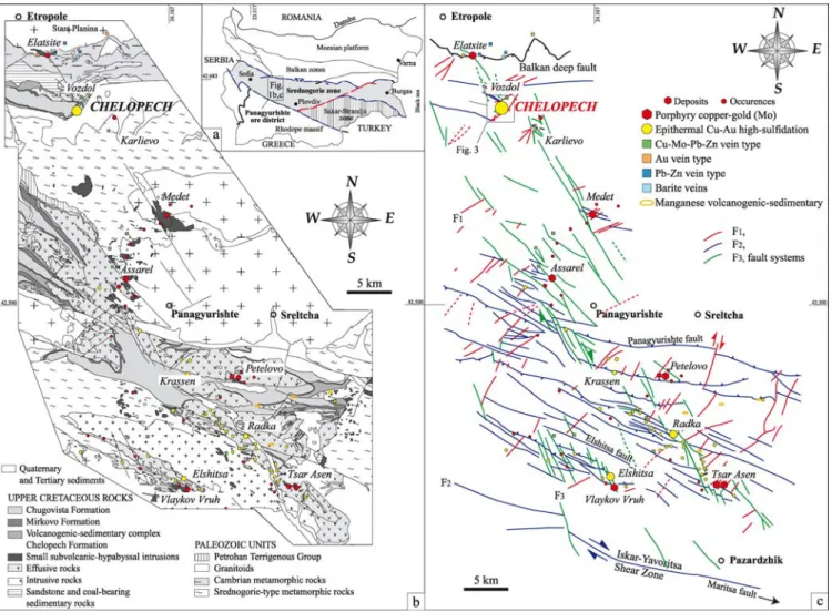
The roughly east–west trending Srednogorie tectonic zone is the Bulgarian segment of the BTS belt, located between the Balkan Zone in the north and the Rhodope Massif and the Sakar–Strandja Zone in the south (Fig. 1a; Boncev
1988; Ivanov1988). The NNW-trending Panagyurishte ore district, approximately 60 to 90 km east of Sofia, belongs to the Central Srednogorie zone (Fig. 1a) and has supplied
approximately 95% of the Bulgarian Cu and Au production up to the present (Mutafchiev and Petrunov 1996, unpub-lished report).
The pre-Mesozoic basement rocks of the Panagyurishte district (Fig.1b) consist of two-mica migmatites, amphib-olites, and gneisses of uncertain Precambrian age, referred to as the Pirdop Group (Dabovski 1988), Srednogorie-type metamorphic rocks (Cheshitev et al. 1995) or the pre-Rhodopian Supergroup (Katskov and Iliev 1993), late Precambrian to Cambrian phyllites, chlorite schists and diabases of the Berkovitsa Group (Haydoutov
2001), and Paleozoic gabbrodiorites, quartz–diorites, tonalites, and granodiorites–granites (Dabovski et al.
1972; Kamenov et al. 2002). All these units underwent ductile deformation and associated low-grade metamorphism at∼100 Ma (Velichkova et al.2004) and are unconformably covered by Turonian conglomerate and sandstone, containing metamorphic rock fragments and coal-bearing interbeds (Aiello et al.1977; Moev and Antonov 1978; Stoykov and Pavlishina2003).
These early sedimentary rocks are in turn crosscut and covered by Upper Cretaceous magmatic rocks, where subvolcanic and effusive rocks are predominant in the
Fig. 1 a Major tectonic zones of Bulgaria (after Ivanov1988). b Simplified geology of the Panagyurishte ore district (modified after Popov and Popov2000). c Structural map of the Panagyurishte ore district (modified after Popov and Popov2000and Ivanov and Dimov2002)
north, whereas intrusive rocks become more abundant in the south, which reveals a deeper erosional level in the southernmost part of the district (Fig. 1b). Andesites predominate in the northern and central Panagyurishte district, whereas dacites are more abundant in its southern sector (Boccaletti et al.1978; Stanisheva-Vassileva1980). Rhyodacites and rhyolites only occur in the central and southern Panagyurishte district (Dimitrov1983; Nedialkov and Zartova 2002). Small, subvolcanic dacite, quartz monzodiorite, and granodiorite intrusions (mostly <1 km2 in size) are comagmatic with the Cretaceous volcanic rocks. Larger sized, northwest-elongated, syntectonic, Upper Cretaceous granodioritic–granitic intrusions are restricted to the southernmost Panagyurishte district along the Iskar–Yavoritsa Shear Zone (Ivanov et al.
2001; Peytcheva et al. 2001), which corresponds to the transition between the Srednogorie zone and the Rhodopes (Fig. 1b). Argillaceous limestone, calcarenite, and sand-stone, with abundant volcanic rock fragments, are inter-bedded with the Upper Cretaceous volcanic rocks. These sedimentary rocks are also Turonian in age, based on paleontological dating by Stoykov and Pavlishina (2003), instead of early Senonian as reported previously (Aiello et al. 1977; Moev and Antonov 1978). Aiello et al. (1977) proposed that this sedimentation could have occurred in an intra-arc basin, related to the destabilization of the volcanic edifice. The interbedded volcano-sedimentary rock assem-blage is transgressively overlain by Santonian–Campanian red limestone of the Mirkovo Formation, and Campanian– Maastrichtian calcarenite and mudstone flysch of the Chugovista Formation (Fig.1c; Aiello et al.1977; Moev and Antonov 1978; Popov 2001). The Senonian flysch units were deposited as outer-fan lobes within one or more basins, which were closely related to the eruptive centers (Aiello et al. 1977) and have probably preserved the volcanic rocks from erosion notably in the northern part of the district (Stoykov and Pavlishina2003).
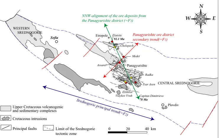
The major ore deposit types of the Panagyurishte ore district (Fig.1b,c) include high-sulfidation epithermal Cu– Au deposits hosted by volcanic and subsidiary sedimentary rocks (Petrunov1995; Popov and Popov1997; Strashimirov and Popov2000; Kouzmanov et al.2002,2004; Moritz et al.2004), and porphyry–Cu deposits hosted by the apical parts of subvolcanic to hypabyssal intrusions, and locally by volcanic and crystalline basement country rocks (Bogdanov1986; Strashimirov and Popov2000; Strashimirov et al. 2002; Von Quadt et al. 2002; Popov et al. 2003; Tarkian et al. 2003). There is generally a close spatial association of porphyry–Cu and high-sulfidation epither-mal deposits in the Panagyurishte ore district (Fig. 1b,c; Petrunov et al.1991; Kouzmanov2001; Tsonev et al.2000; Kouzmanov et al.2001; Strashimirov et al.2002; Moritz et al. 2004), which is also recognized in other parts of the BTS belt, such as at Bor in Serbia (Jankovic 1990; Jankovic et al. 1998). The porphyry–Cu and high-sulfidation Cu–Au deposits of the Panagyurishte district are aligned along a north–northwest oriented trend, which is oblique with respect to the east–west trending Srednog-orie zone in Bulgaria (Fig. 1a). There is a southward
decrease in the age of the calc-alkaline magmatism and the associated ore deposits from about 91–92 Ma in the north at Elatsite and Chelopech, through 89–90 Ma at Medet and Assarel, about 86 Ma at Elshitsa and Vlaykov Vruh, and 78 Ma at Capitan Dimitrievo in the southernmost part of the Panagyurishte district (Fig.1b; Von Quadt et al.2005).
Geodynamic setting of the Panagyurishte ore district
The Panagyurishte tectonic evolution started during the Mesozoic and has been affected by several tectonic phases during the Cenozoic. The southern part of the district is bound by Tertiary intrusive rocks of the Rhodope Massif, which are separated from the Srednogorie belt by the Maritsa Fault (Fig. 1c); whereas the Stara Planina Paleozoic granitic rocks form the northern border, along the Balkan deep fault (Fig.1c).
According to Ivanov (1988), the sedimentation in the Stara Planina and Srednogorie Zone started during the Triassic and is marked by shallower facies (conglomerate and sandstone), which overlies folded Paleozoic basement rocks. Recently, Velichkova et al. (2004) determined that these basement rocks were metamorphosed and ductilely deformed at ca. 100 Ma, before the formation of the Srednogorie back-arc basin. During the Senonian, the Balkan was marked by the opening of the Srednogorie back-arc basin (Ricou et al. 1998), which initiated volcanism and detrital sedimentation.
Late Cretaceous tectonics
Recently, Kamenov et al. (2003a,b,2004) and Von Quadt et al. (2003, 2005) proposed that Late Cretaceous sedimen-tary basin formation was initiated along strike–slip faults and suggested that the Late Cretaceous magmatism and ore formation was related to slab rollback to the south during northward subduction. This scenario is supported by the fact that there is a progressive age decrease of magmatic and ore forming events, starting in the north at about 92 Ma and ending at about 78 Ma in the south of Panagyurishte ore district (Kamenov et al.2003a,b,2004; Von Quadt et al.
2003, 2005). Lips (2002) contends that slab rollback operated only from approximately 30 Ma to the present day, and that it was the back-arc extension that initiated Late Cretaceous magmatism. According to Lips (2002), the low density and young age of the subducted lithosphere argue against a subducted slab-detachment scenario (e.g., Neubauer2002) during the Late Cretaceous.
Jelev et al. (2003) suggested that the Late Cretaceous volcanism in the Chelopech area may have formed in pull-apart basins, which initiated along a NE-trending fault segment. The detrital sedimentary sequence in the Chelopech area, which is associated and covered by Upper Cretaceous magmatic rocks, has been dated by Stoykov and Pavlishina (2003) as Turonian, suggesting a rapid development of the pull-apart sedimentary basins and linked volcanism.
Palynological data on the flysch of the Chugovista Formation reveal a Maastrichtian age for these marine sedimentary rocks, which overlie the Turonian volcano-sedimentary succession (Stoykov and Pavlishina 2004). The deposition of a flysch succession during the Maas-trichtian suggests syn-orogenic detrital terrigenous sedi-mentation in basins, which is probably linked to the Rhodopian shortening and a change of the orientation of the principal stress axes from an extensional to a compressional regime.
The high-sulfidation Cu–Au epithermal Chelopech deposit
The Chelopech deposit is located in the northernmost part of the Panagyurishte ore district, about 7–8 km southeast of the major Elatsite porphyry-Cu deposit. The Chelopech deposit is hosted by Upper Cretaceous volcanic and volcano-sedimentary units, transgressively overlying Precambrian and Paleozoic metamorphic rocks (Figs. 2a and 3a). The Upper Cretaceous rock sequence consists of detrital sedimentary rocks derived from the basement, and andesitic, dacitic to trachyandesitic subvolcanic bodies, lava flows, agglomerate flows, tuffs, and epiclastic rocks. They are
transgressively covered by sandstone, argillaceous lime-stone, and the terrigenous flysch sequence of the Chugovista Formation (Fig. 2a). The orebodies are hosted by (1) a subvolcanic body with an andesitic texture and composition, associated with phreatomagmatic breccia, and (2) sedimen-tary rocks with oolithic, biodetrital and sandstone layers interbedded with (3) volcanic tephra-tuff containing accre-tionary lapilli and pumices (Jacquat2003; Moritz et al.2003; Chambefort2005).
Laterally outward from the orebodies, there are four alteration assemblages at Chelopech, with (1) an innermost silicic zone with massive silica, sparsely developed vuggy silica, disseminated pyrite and aluminum –phosphate–sul-fate (APS) minerals; (2) a quartz–kaolinite–dickite zone with pyrite, APS minerals, and anatase; (3) a widespread quartz–sericite alteration zone; and (4) an external propylitic zone. Below the present mining level (about 400 m below surface), samples from 2-km deep drillholes reveal that the alteration evolves into a diaspore –pyro-phyllite–alunite–zunyite–rutile–APS mineral assemblage (Petrunov1989,1995; Georgieva et al.2002).
The mineralization is characterized by three successive ore stages (Petrunov1994,1995; Jacquat2003). The first Fe–S stage consists of disseminated pyrite, which can become locally very abundant and results in a total
Fig. 2 Surface maps of the Chelopech area. a Geological map of the Chelopech area. b Schematic structural map of the Chelopech deposit. Arrows show the location of the cross-sections in Fig.3
replacement of the host rocks to form massive sulfide orebodies, particularly in more permeable rock units such as clastic and calcareous sedimentary rocks and volcanic tuffs. This early stage is followed and partly brecciated by an intermediate Cu–As–S stage, predominantly as veins, which is the Au-bearing event and constitutes the economic ore mined at Chelopech. The mineral assemblage includes enargite, luzonite, covellite, goldfieldite, chalcopyrite, tennantite, bornite, and native gold, which constitutes the main Au carrier (Bonev et al.2002). The late uneconomic Pb–Zn–S stage consists of galena, sphalerite, pyrite, chalcopyrite, and barite veins. The Chelopech Mine produces approximately 700,000 t/year of ore and contains 25 Mt measured and indicated reserves at 4 g/t Au and 1.5% Cu (Dundee Precious Metals Inc data; http://www. dundeeprecious.com/).
The Chelopech deposit is accompanied by two miner-alized occurrences. The Charlodere occurrence is located about 1 km to the northeast of the Chelopech mine (Fig.2a) and is considered as an exhumed part of the Chelopech deposit by Popov et al. (2000a). The authors considered that the Charlodere orebodies are lenslike to shear-zone types and probably controlled by radial faults. This occurrence is hosted by a strongly altered breccia of a volcanic origin and a massive andesitic body. The rocks are affected by a propylitic alteration, with the occurrence of hydrothermal biotite and chlorite, grading into quartz– sericitic alteration and an advanced argillic alteration, including alunite (Lerouge et al. 2003). The second occurrence is the polymetallic Vozdol prospect, about 1 km to the north–northeast of the Chelopech deposit (Fig. 2a), which consists of base-metal sulfides, quartz, carbonate, barite, and fluorite veins, surrounded by an alteration zone comprising carbonate, adularia, and sericite. This occurrence was considered as a low-sulfidation system by Mutafchiev and Petrunov (1996, unpublished report) and Popov et al. (2000a), and would be reclassified as an intermediate-sulfidation occurrence according to the new terminology of Hedenquist et al. (2000). The spatial association of the polymetallic Vozdol occurrence and the Chelopech deposit is analogous to other base-metal veins at the periphery of high-sulfidation systems (Sillitoe 1999; Hedenquist et al.2000,2001).
The Chelopech structural setting
Description of the fault system
The investigations on the Chelopech tectonic system discussed in this contribution are limited to the north by the Petrovden fault and to the south by the Chelopech thrust (Fig.2). Figure1c presents a structural map for the
Panagyurishte ore district based on data from Popov and Popov (2000), whereas Figs. 2b and 4show in detail the new interpretative surface and underground structural maps of the Chelopech deposit. The Chelopech deposit is overlain by folded Upper Cretaceous sedimentary rocks of the Chelopech syncline, including the Chugovista, Mirkovo, and Chelopech Formations (Fig.3a). The axial plane of the syncline has a N110–120° trend in the western part and has been affected by Tertiary deformation in the eastern part, described as Pyrenean deformation by Antonov and Jelev (2001). This late deformation induced a change in the plane orientation from N110 to N70°, associated with the Vozdol syncline affecting the sandstone of the Chelopech Formation (Fig.2b).
Three principal fault orientations have been recognized in the Panagyurishte ore district, which are also present in the Chelopech area (Popov and Popov 2000; Ivanov and Dimov2002; Jelev et al.2003; this study):
(1) ∼NE-trending faults, termed F1 in this study, which include the Chelopech thrust (Fig.2b)
(2) ∼E–W-trending faults, termed F2 in this study, essentially subvertical and which are parallel to the regional E–W trend of the Srednogorie belt
(3) ∼N155 faults, termed F3in this study, parallel to the regional NNW-alignment of the ore deposits of the Panagyurishte ore district
These three fault orientations are identical to the major fault orientations described by Popov and Kovachev (1996) in the Chelopech area. They are also recognized in the entire Panagyurishte district (Fig.1c).
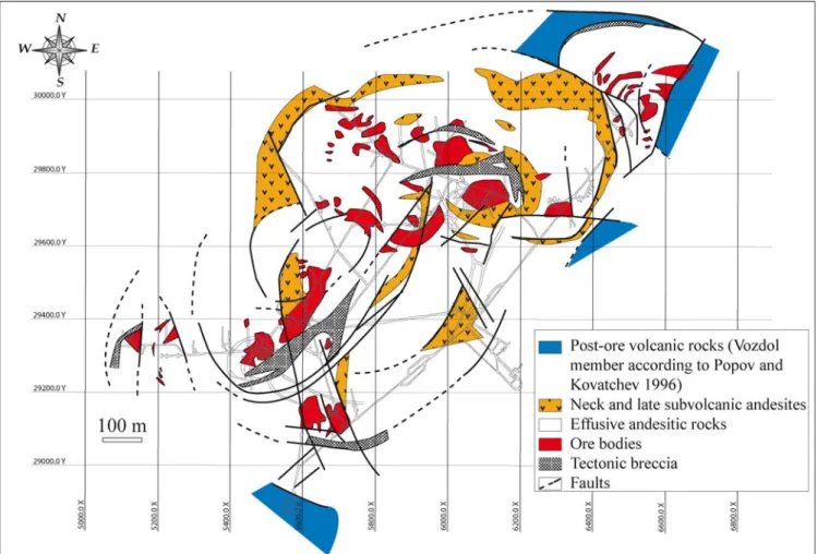
Figure 5 is a geological and structural map of the Chelopech deposit by Popov and Kovachev (1996), and shows that these authors have also described volcanotec-tonic radial and concentric faults in the central part of the volcanic edifice of Chelopech, in addition to the regional NNW-uniform-trending faults. The activation of these faults and the associated intense fracturing and brecciation have been attributed by these authors to the formation of a caldera and the intrusion of several subvolcanic bodies along with the development of mineralization. The authors described post-ore volcanic rocks, termed as Vozdol Member, which are interpreted to intersect hydrothermally altered rocks and the orebodies in the northwestern part of the deposit (Fig.5). However, these concentric faults and post-ore volcanic rocks have been neither recognized during our field investigations nor by the previous study of Jelev et al. (2003).
Our investigations at Chelopech show that:
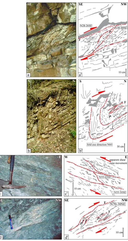
F1faults (highlighted in red in all figures) have a∼N20
to N55 orientation, and dip approximately 40 to 50° to the south (Figs. 2b and 4). They are thrusts or reverse faults (Fig.6a,c,d) and are generally associated with meter-scale to several tens of meter-sized folds with∼NE-trending axes (Fig.6b). Shear sense indicators are recognized along the fault planes with P and Y shears and deflection of the foliation (Fig.6a,c,d), which are characteristic of compres-sion in a brittle regime (Passchier and Trouw1998, p. 128). The folds are developed in the Upper Cretaceous
3Fig. 3 Cross-sections perpendicular to F1 and located a on Chelopech mine and b on Charlodere occurrence, c perpendicular to F3and F2and containing the exploitation blocks, 151, 150, 17, 18. The numbers1 and 2 of the Chelopech thrust movements cor-respond to a compressional stage followed by the extensional stage
sedimentary cover and are thus post-volcanic structures, with the N10 to N55-trending fold axes (Fig.7, surface data stereograph). This fault system is also characterized in some places by sinistral strike–slip movement along the major Chelopech Thrust, as shown by the thrust slices at the Charlodere occurrence and in the southern part of the Chugovista Valley (Fig.2b).
F2faults (highlighted in blue in all figures) have a∼N90
to N110 trend with a subvertical to 60° southward dip. They are subparallel to the E–W orientation of the Srednogorie belt (Figs. 1c,2b, and 4) and are conjugate dextral and sinistral strike–slip faults. The sense of movement along the F2faults is not possible to determine
from surface exposures; however, in underground expo-sures, they display essentially a dextral strike–slip move-ment (Fig.4). On the basis of their orientations, this fault family can be considered as identical to the WNW-oriented thrusts attributed by Antonov and Moev (1978) and Popov and Popov (2000) to the so-called Laramian phase, which is Maastrichtian–Tertiary in age. However, no evidence of thrust characteristics has been found in this study.
F3 faults, highlighted in green in all figures, are
characterized by a ∼N135 to N170 trend with a vertical to 60° dip to both the east and west (Figs.2b and4). They form a conjugate system, with the dextral F3faults having a
NE-directed dip and the conjugate sinistral F3faults having
a SW-directed dip. F3faults are subparallel to the regional
ore deposit alignment in the Panagyurishte ore district (Fig. 1c). Popov and Popov (2000), Popov et al. (2001), and others described similar fault orientations, which were defined as Laramian and Illyrian by these authors and which correspond to Maastrichtian–Tertiary, N135–N170-trending strike–slip movements.
Figure 7displays equal area stereographs for the three principal fault generations identified during surface and underground mapping. F1 is the most abundant fault
system and, together with the Chelopech Thrust, deter-mines the present-day geometry of the southern flank of the Chelopech syncline (Figs. 2b and 3a). Fault orientations measured in the mine galleries exhibit a strong dispersion. Therefore, for the sake of clarity, underground faults are plotted on separate stereographs for each of the mining blocks (Fig. 7). The three fault types were observed in every mining block that was mapped. F3 faults are
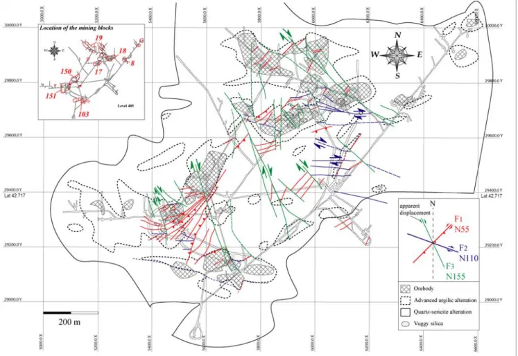
predominant in block 17 on level 395 (Figs.4and7), the orebody of this block is completely overprinted by this fault system. F1and F2fault types are also present, notably
on level 405, where faults exhibit a wide variety of orientations. Figure8a shows the structural relationships of the orebody in block 17 on level 405 with the different fault Fig. 4 Interpretative structural map of the Chelopech mine, level 405
populations. The orebody is essentially delimited by faults. F1 and F2 faults determine the western and southern
borders of the block and are displaced by F3faults.
The mining blocks 17 and 18 are less faulted than the blocks in the southwestern part of the mine such as blocks 103, 150, and 151 (Figs.4and8). Faults in block 151 on levels 400 and 405 are predominantly of the F1 type.
Figure8b displays a detailed structural map from block 151 on level 405. The southern limit of the orebody is controlled by an extensive F1 fault zone. The orebody is essentially
developed in altered volcanic tuff and sedimentary rocks. Similar to blocks 17 and 18, the orebody of block 151 is overprinted by F3 faults. The southern limits of each
orebody are generally more intensively faulted than the northern ones (Fig.8b, Arizanov, personal communication, 2001).
Relative fault chronology
The chronology of the different fault generations and the geometric relationships among them are not obvious in the field. Different cross-sections have been produced to determine the geometric relationships (Fig. 3). They are based on surface and underground mapping, drillcore descriptions, 3-D GEMCOM models and preexisting
cross-sections of the Chelopech deposit (Mutafchiev and Petrunov 1996, unpublished report; Popov and Kovachev
1996). These cross-sections were oriented perpendicular to a given fault set. For example, the cross-sections of Fig.3a, b are perpendicular to the orientation of the F1fault system,
whereas the cross-section of Fig.3c is perpendicular to the orientation of the F2and F3fault systems. One has to keep
in mind that the Panagyurishte district has been subject to various deformation stages (Popov and Popov 2000; Antonov and Jelev 2001). Therefore, the present-day kinematics revealed by the faults is only representative of the latest stage(s) of the tectonic evolution of the Panagyurishte district, particularly the dextral strike–slip tectonics described by Ivanov et al. (2001) and late-stage fault relaxation.
It appears that F1faults are characterized by a late-stage
reverse sense of movement associated with maximum vertical displacements of several hundred meters and which also overprint the Late Cretaceous post-mineraliza-tion sedimentary rocks covering the ore deposit, including the Mirkovo and Chugovista Formations (Fig. 3a). The silicified zone, which defines the innermost part of the alteration underground, has been displaced along the F1
faults. The Chelopech deposit has probably been tilted during this Tertiary deformation stage, which was defined as the Pyrenean Stage by Popov and Kovachev (1996). Fig. 5 Underground geology of the Chelopech deposit according to Popov and Kovachev (1996)
Fig. 6 Outcrop-scale structures associated with the F1fault system. a Shear sense indicators in the flysch of the Chugovista Formation. b Fold in flysch of the Chugovista Formation, Chugovista valley. c, d Thrust structures in the mine galleries
Detailed mapping of blocks 17 and 151 on level 405 (Fig. 8) shows that movement along the F1and F3 faults
displaced different parts of the orebodies with respect to each other and, in some places, crosscut the F2 faults
(Fig. 8a). Our mapping shows that the long axes of the orebodies, the breccia bodies, and the silicified zones are subparallel to the orientation of the F1and F2faults (Fig.4).
Therefore, we conclude that the F1 and F2 fault systems
controlled the emplacement of the orebodies during the Late Cretaceous, with the F1 faults being reactivated as
thrusts or reverse faults during the Alpine orogeny, after magmatism and ore formation. The F2 faults exhibit the
same orientation as the E–W-elongation of the Srednogorie belt, which is considered as a subduction-related volcanic belt (see above). Therefore it is coherent to consider this fault system as directly linked to Upper Cretaceous magmatism and thus mineralization. Furthermore, the F2
fault system has also been reactivated and displaced during Tertiary strike–slip movements along the F1faults (Figs.2b
and4).
Figure3b shows a cross-section through the Charlodere occurrence (Fig.2), where the orebodies and the silicified zones have a NE–SWelongation with a northern dip, which contrasts with the southern dip of the Chelopech orebodies (Fig.3a). The Charlodere orebodies occur along F1faults
and have been affected by the reactivation of the F1faults
in a thrust movement after their formation, like the Chelopech orebodies. On the basis of drillcore description, the Charlodere silicified and mineralized zones are affected by NE–SW oriented faults. This cross-section shows the structural control of the mineralization and overprinting by the reactivation of the same F1 faults during the
post-mineralization tectonic event. The present-day surface location of the Charlodere occurrence (Fig. 3b) can be explained if we consider that the Charlodere mineralization is a slice of the Chelopech deposit, which has been uplifted and exposed on the surface as a consequence of dextral strike–slip thrust movements as a positive flower structure (Woodcock and Fischer 1986) along the “Chelopech Thrust” (Figs.2b and3a,b).
Figure3c displays a cross-section perpendicular to the F3
faults, along the mining blocks 151, 150, 17, and 18, respectively, from SW to NE. It clearly shows that the F3
faults and also the F2faults overprint the Chelopech deposit
with a normal sense of movement and delimit the present-day geometry of the deposit. The silicified zone was displaced by F3 faults. However, the cross-section on
Fig.3c still clearly reveals a subhorizontal geometry of the silicified zone, which is akin to typical, subhorizontal “mushroom shapes” of alteration zones described in numerous epithermal high-sulfidation deposits (e.g., Sillitoe
1997, 1999; Corbett and Leach 1998; Hedenquist et al.
2000), and likely reveals a lithological control of the alteration. Thus, although the deposit appears to be crosscut by the F3faults, the displacement along them was relatively
small, as shown by SW–NE sections.
The F1faults were reactivated during deformation events
postdating magmatism and mineralization. The F3 faults
are interpreted as transfer respectively tear faults, which accommodated thrusting during reactivation of the F1
faults (Fig. 9). The F3 faults are characteristic of
transtensional strike–slip faults, associated with a normal movement. Although one may attribute a late timing to the F3 faults based on present-day crosscutting relationships
among faults, the regional north–northwest ore deposit alignment of the Panagyurishte district is parallel to the orientation of the F3faults. Therefore, they are linked to a
regional ore deposit control that was certainly active at the start of ore formation in the northern Panagyurishte ore district, i.e., when the Chelopech deposit was formed.
In conclusion, the relative fault chronology among F1,
F2, and F3 cannot be deduced anymore due to the Late
Cretaceous–Tertiary overprint as a consequence of short-ening across the Rhodopes and the Srednogorie zone (Ivanov 1988; Ricou et al. 1998), the Tertiary compres-sional tectonics at Chelopech, described as late Pyrenean structures by Popov and Popov (2000) and Antonov and Jelev (2001), and the late dextral strike–slip tectonics (Ivanov et al.2001). However, the geological relationship
151-400 103-425 150-400 151-405 17-405 18-395 surface data 17-395 18-405 data from mine galleries F1 F3 F1 F3 F2 fold axes Chelopech syncline axes
Fig. 7 Fault plane projections on equal area stereonets, lower hemisphere, for surface faults and faults in each of the exploitation blocks (numbers indicate the exploitation block and the level, respectively). Faults in mine galleries are displayed as pole projections for the sake of clarity
with orebody and alteration zone geometries indicates that all three fault families were active during ore formation.
The fault history presented in this study has some implications for exploration. Indeed, because of the Tertiary compressional tectonics, undiscovered miner-alized zones of the Chelopech deposit could have been overthrust by presently mined orebodies. Furthermore, Tertiary transtensional dextral displacements along NNW-oriented F3 faults, i.e., parallel to the Panagyurishte
alignment, may have also affected the mineralized system. Thus, undiscovered orebodies may be located at deeper structural levels northwesterly with respect to the present mine, such as beneath block 19W (Fig. 4) and in the southeastern parts of the Chelopech syncline (Fig.3a).
Geodynamic evolution of the Chelopech deposit and regional overview: a discussion
Tectonic evolution at Chelopech
Based on the stratigraphic and the geometric field relationships presented above, a summary of the tectonic evolution of the Chelopech area can be given as follows, from oldest to youngest (Fig.10):
(1) The geometry of the alteration and mineralized zones and the shape of the hydrothermal breccia bodies show that the Chelopech hydrothermal system was con-trolled by the ∼N55-trending F1 and the
∼N110-trending F2faults. In addition, the∼N155-trending F3
faults are parallel to the regional NNW-trending ore distribution in the Panagyurishte district. Therefore, we conclude that these faults are early features, Late Cretaceous in age, which were present before deposi-tion of the Upper Cretaceous sandstone, limestone and flysch of the Chelopech, Mirkovo and Chugovista Formations recognized in the Chelopech syncline (Fig. 3), and before the Tertiary tectonic overprint. Our study clearly documents the early nature of these faults and the control they have played during high-sulfidation ore formation.
(2) The entire Upper Cretaceous rock succession was folded after deposition of the Upper Cretaceous sandstone, limestone, and flysch (turbiditic sandstone) of the Chelopech, Mirkovo, and Chugovista Forma-tions, thus producing the WNW-oriented Chelopech syncline (Figs. 2b and 10b) after the Maastrichtian. These folds, attributed to the Laramian tectonic phase by Antonov and Moev (1978), Ivanov (1988), Popov and Popov (2000), Popov (2001), and Jelev et al. (2003), are recognized in the entire Panagyurishte district; thus, they are regional features.
(3) The WNW-oriented folds were followed by thrusting along the ∼NE-trending Chelopech Thrust (Fig. 2b) and accompanied by folds with ∼NE-oriented axial planes in the Maastrichtian sedimentary cover rocks, such as the Vozdol syncline (Figs. 2a and 10c). The early F1 and F2 faults, which have controlled
high-sulfidation ore formation, were reactivated as reverse faults or thrusts and dextral faults, respectively, during this compressional overprint, which also tilted the Chelopech deposit to the northwest. The F3faults were
reactivated as transfer faults during Tertiary thrusting along the F1 faults. This event, described as the
Pyrenean and Illyrian phase by Popov and Kovachev (1996), Popov and Popov (2000), and Jelev et al. (2003), has only a limited development in the Panagyurishte district and besides the Chelopech area; they have only been recognized within the Mechit and Raina Knyaginya synclines, south of the town of Strelcha (Fig.1b,c; Popov and Popov2000). (4) During the Neogene kinematics, the Chelopech area was
characterized by an extensional regime (Ivanov et al.
2001, Velichkova et al. 2004). Some of the F1 faults
were reactivated as normal faults, as documented by the change in kinematics along the Chelopech Thrust to a normal fault along the southern margin of the Chelopech syncline (Figs.2b and10d). This extensional regime is also recognized in the entire Panagyurishte ore district with the formation of horsts and grabens, the formation of Cenozoic sedimentary basins and uplift of Paleozoic basement (Fig. 1b,c; Ivanov et al.2001). The ∼N100-oriented dextral strike–slip faults, such as the Maritsa fault (Fig.1c; Ivanov et al.2001), are parallel to the F2
Fig. 9 Interpretative structural map of the western part of the Chugovista Valley, showing the relationship between F1 and F3 faults. The numbers 1 and 2 of the Chelopech thrust movements correspond to a compressional stage followed by the extensional stage
3Fig. 8 a Detailed map of block 17 on level 405. b Detailed map of block 151 on level 405
faults and are contemporaneous with movement along the F3strike–slip faults.
Our investigation, documenting the structural control of the high-sulfidation orebodies and their tectonic overprint, together with previous structural investigations in the Panagyurishte district allow us to address the variation of the stress states during the geological evolution of this district. According to Ivanov et al. (2001), the present-day extensional regime in the Panagyurishte district (stage 4 above) is related to dextral transtensional strike–slip tectonics along the ∼WNW-oriented Iskar–Yavoritsa Shear Zone (Fig.1b). The formation of the ∼NE-oriented Chelopech Thrust (Fig. 2b) and the∼NE-oriented Vozdol Syncline (Fig. 2b), recognized during stage 3, would be compatible with such a dextral strike–slip tectonic setting and a roughly N–S to NW–SE oriented compression (σ1)
based on classical structural models (Woodcock and Fischer 1986; Sylvester 1988), although they record transpression rather than transtension. The orientation of the WNW-oriented folds of stage 2, such as the Chelopech syncline and affecting the Late Cretaceous magmatic and sedimentary rocks in the Panagyurishte district, are incompatible with dextral strike–slip tectonics along the ∼WNW-oriented Iskar–Yavoritsa Shear Zone, according to classical structural models (Woodcock and Fischer 1986; Sylvester 1988). These folds require a roughly NNE-oriented compression (σ1), which could be compatible with
a regional sinistral strike–slip tectonic setting (Woodcock and Fischer1986; Sylvester1988) within the Srednogorie belt. Therefore, the geometric relationships reveal that there has been a rotation of the orientation of the principal stress axes in the Panagyurishte district, from a roughly NNE-oriented compression during folding of the Late Cretaceous rocks covering and hosting the Chelopech deposit, toward a roughly N–S to NW–SE compression, as recorded by the younger NE-trending Chelopech Thrust and the present-day dextral transtensional strike–slip tectonics described by Ivanov et al. (2001). This interpre-tation agrees with the studies of Antonov and Jelev (2001) about post-mineralization tectonics at Chelopech. There is no clear structural evidence to constrain the tectonic setting during Late Cretaceous volcanism and sedimentation of the host rocks of the Chelopech deposit, as well as during ore formation. The nature of the sedimentary host rocks described by Aiello et al. (1977) and Moev and Antonov (1978) indicate sedimentation and, by association volca-nism in an extensional basin setting before
high-sulfida-F1 F2 a NE F1 F3 c σ1 F3 d Chelopech Thrust F1 F2
F
1 F2 b Chelopech syncline F3 σ1 Chelopech syncline Vozdol syncline ? ? F2 ? ? Chelopech Thrust3Fig. 10 Schematic tectonic evolution of the Chelopech deposit. a Late Cretaceous sinistral transtensional duplex system and setting of the magmatism and the mineralization. b Late-Maastrichtian to Tertiary Alpine deformation phase, formation of WNW-trending thrusts (F2) and associated N110°-trending folds (formation of the Chelopech syncline). c Tertiary Alpine Eocene phase with formation of a dextral transpressional duplex, thrust slices (F1) and associated folds post-dating ore formation, the folds have a NE-oriented axial plane. d Late Alpine-neotectonic dextral transtensional duplex, extensional system, reactivation of the Chelopech thrust fault as a normal fault
tion, ore formation. It can only be speculated whether the F1and F2faults, which are the principal faults controlling
the mineralization at Chelopech, were already active during Late Cretaceous basin formation and magmatism. If this were the case, then their orientations would be compatible with sinistral strike–slip tectonics (compare the F1, F2, and
F3fault orientations at Chelopech with Figs. 6e and 8a in
Woodcock and Fischer 1986), which would have been transtensional during basin sedimentation and switched to transpressional during the WNW-trending folding of the Late Cretaceous sedimentary and volcanic rocks after (or during?) high-sulfidation ore formation.
Relationship between ore formation events and the tectonic evolution of the Panagyurishte ore district
To discuss and understand the geodynamic evolution of the Chelopech deposit, it is necessary to consider the deposit on a regional scale, with respect to both the E–W oriented Srednogorie belt and the NNE–SSW ore deposit alignment of the Panagyurishte ore district.
The Panagyurishte ore deposits are hosted by Late Creta-ceous magmatic rocks, which throughout the Panagyurishte district, are transgressively covered by the Campanian reddish limestone of the Mirkovo Formation (Popov and Popov 2000; Popov 2001; Popov et al.2003; Stoykov and Pavlishina 2003; Bogdanov et al.2004). The limestone of the Mirkovo Formation is unaltered and contains at the bottom, a volcano-sedimentary conglomeratic layer with altered and mineralized fragments (Popov and Popov2000; Popov2001). This observation indicates that the ore deposits of the Panagyurishte ore district were formed before the sedimentation of the Upper Cretaceous Mirkovo Formation (Popov and Popov 2000) and, therefore, before Late Cretaceous and Tertiary tectonic deformation.
In the entire Panagyurishte ore district, the Late-Cretaceous volcano-sedimentary and overlying limestone and flysch units have been affected by WNW-oriented folds at the end of the Maastrichtian (Laramian stage of Karagjuleva et al.1974; Antonov and Moev1978; Popov and Kovachev 1996; Popov and Popov 2000; and Popov
2001). Numerous faults accompany the Maastrichtian– Tertiary folds, the most abundant being WNW-trending thrusts (Fig.1c), such as the Panagyurishte and the Elshitsa faults, and associated diagonal NNW-oriented faults partly interpreted by Popov and Popov (2000), and Popov (2001) as reactivated older faults. Locally, the WNW-oriented folds were overprinted by Tertiary northeast-oriented folds and faults at Vozdol and Chelopech, respectively (Fig.2b), and Mechit and Raina Knyaginya synclines, south of the town of Strelcha (Fig. 1b,c; Popov and Popov 2000; Pyrenean deformation of Karagjuleva et al.1974; Antonov and Moev1978; Ivanov1988; Popov and Kovachev1996; Antonov and Jelev2001; Popov and Popov2000; Popov
2001,2002). At the present-day, the Panagyurishte district is composed of different horst and graben structures delimited by regional transform faults with a ∼N110–120 trend
resulting from a transtensional, dextral strike–slip tectonics (Fig.1c; Ivanov et al.2001, personal communication).
The sequence of early ore formation, followed by Late Cretaceous deposition of sedimentary rocks (i.e., the Mirkovo Formation), Maastrichtian–Tertiary folding and thrusting, and late-stage transtensional dextral strike–slip deformation events, is identical throughout the Panagyur-ishte ore district and is comparable to the evolution we have described for the Chelopech area. Therefore, our literature review suggests a rotation of the principal stress axes after the ore formation events and before the present-day dextral strike–slip tectonic setting for the entire Panagyurishte district, because the WNW-oriented folds were formed after the emplacement of the ore deposits and because the orientation of these folds is incompatible with the orientation of the principal stress axes required for dextral strike–slip tectonics based on classical tectonic models (Woodcock and Fischer1986; Sylvester1988).
There is also a coherent orientation of the orebodies among the high-sulfidation deposits across the Panagyur-ishte district, including the Radka, Krassen, and Elshitsa deposits of the southern part of the district (Fig. 1b). The Radka orebodies follow a ∼N120 orientation with a northern dip, i.e., parallel to the F2 fault system
(Fig. 11a; from Popov and Popov 1997; Tsonev et al.
2000; Kouzmanov et al.2002; Popov2002; Bogdanov et al. 2004). The Krassen deposit is limited between two subparallel WNW-trending faults, and the lenticular orebodies, which are hosted by pipe-like tectonic breccia zone, have the same orientation with a dip of about 50° to NE (Bogdanov et al. 2004). The Elshitsa deposit is also hosted by a N110–115°-oriented dacitic subvolcanic body, which is parallel to the F2 fault system and the Elshitsa
orebodies have the same orientation (Fig. 11b; from Chipchakova and Stefanov 1974; Kouzmanov 2001). According to Popov (2001), the Elshitsa volcano–tectonic system is characterized by an intense fracturing along N120–N130 and N60–N80-trending faults, and magmatic bodies follow the same trend. Thus, it appears that the Panagyurishte high-sulfidation epithermal deposits and associated magmatic rocks are locally controlled by the same F1 and F2 fault systems as in Chelopech and are
aligned regionally along the NNW-oriented F3fault pattern
(Fig. 12). Therefore, we conclude that the ore deposits throughout the Panagyurishte district were formed under approximately similar stress conditions, i.e., under similar orientations of the principal stress axes. The coherent sequence of magmatic, hydrothermal and tectonic events, and orebody orientations from North to South, suggests that the ore deposits of the entire Panagyurishte ore district were formed in a similar tectonic environment as the one we have deduced for the Chelopech area.
Late Cretaceous tectonic setting linked with syn-arc magmatism and associated mineralization
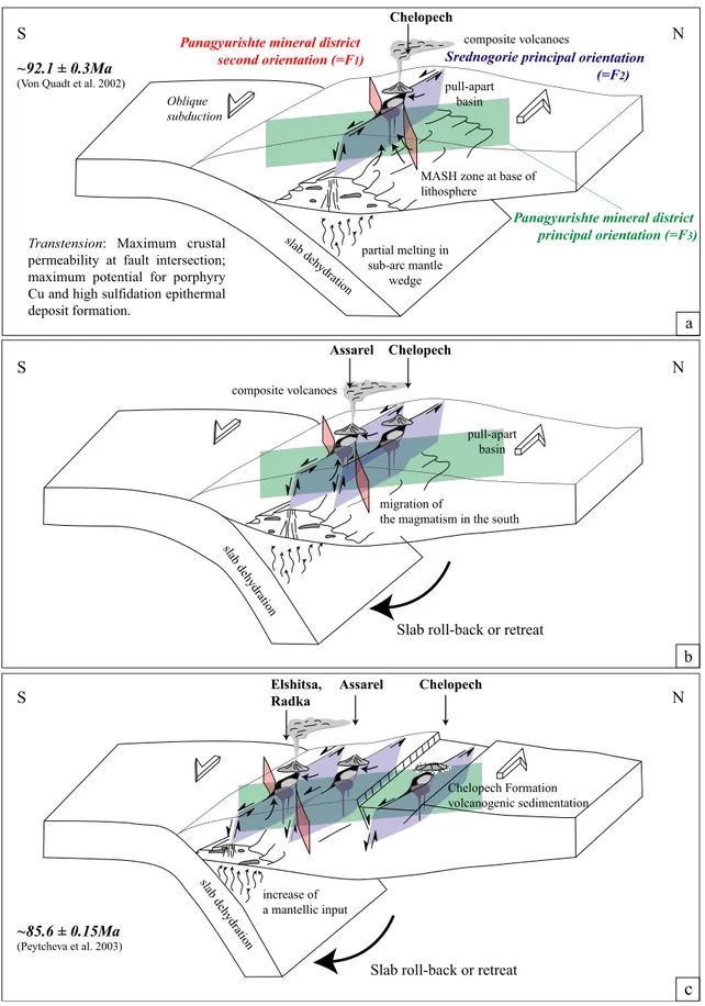
Figure13is modified from Tosdal and Richards (2001) and displays a schematic diagram illustrating the relationship
among convergent margin tectonics, upper plate structure, and magmatism during the evolution of the Panagyurishte ore district. According to Tosdal and Richards (2001,
2002), the development of porphyry–Cu and high-sulfida-tion epithermal deposits is favored during a relaxahigh-sulfida-tion of regional stress conditions. The major arc-parallel structures will be closed when the subduction setting is characterized by arc-normal compression, while during extensional or transtensional stress periods, these structures provide enhanced permeability, therefore favoring magma em-placement in the crust. The intersections of different fault generations in a transtensional regime will favor the development of strike–slip duplexes (Woodcock and
Fischer 1986) and can result in the formation of pull-apart basins.
By analogy to the model of Tosdal and Richards (2001,
2002), the WNW–E-oriented F2faults of the Panagyurishte
ore district are interpreted as major arc parallel faults during oblique subduction, and the NE-oriented F1faults
are considered as strike–slip faults delimiting the major arc parallel faults (Figs.12and13), allowing the formation of pull-apart basins and eventually resulting in the emplace-ment of magmatic rocks and ore deposits at Elatsite and Chelopech.
Progressive southward migration of magmatism along a deep-seated structure, parallel to the orientation of the Fig. 11 a Cross-section of the Radka deposit (after Popov and Popov1997; Tsonev et al.2000; Kouzmanov et al.2002). b. Cross-section of the Elshitsa deposit (after Chipchakova and Stefanov1974; Popov et al.2000b)
NNW-oriented F3 faults (Fig. 13b), is explained as a
consequence of slab rollback (Kamenov et al.2003a,2004; Von Quadt et al. 2003), or a slab retreat (Handler et al.
2004; Von Quadt et al. 2005). Two additional pull-apart basins bound by strike–slip faults were formed within a tectonic setting characterized by strike–slip duplex south of the Chelopech–Elatsite stripe, the first one being the Assarel–Panagyurishte stripe (Fig. 13b), and the second one the southernmost Elshitsa–Radka stripe (Fig. 13c). Sedimentation of the volcanogenic sandstone of the Chelopech Formation is probably linked to the destruction of the volcanic edifice at Chelopech (Stoykov and Pavlishina2003) during on-going extension as a result of the south-directed slab rollback or retreat.
Conclusions
Our investigation shows that the emplacement of the orebodies and the alteration zones of the Chelopech high-sulfidation deposit have been controlled by ∼N55 and ∼N110-trending faults at a time when the tectonic setting changed from extensional, during Late Cretaceous basin sedimentation and magmatism, to compressional with WNW-oriented folding of the Upper Cretaceous host and cover rocks of the ore deposit, indicating a roughly NNE–
SSW compression. Thus, the Chelopech deposit is structurally controlled like other world-class high-sulfida-tion epithermal deposits (e.g., Mitchell and Leach 1991; Corbett and Leach1998; Hedenquist et al.1998), and was formed at the end of an extensional period or during a transient period of stress relaxation, which are particularly favorable tectonic settings for the formation of high-sulfidation epithermal deposits according to Tosdal and Richards (2002), Sillitoe and Hedenquist (2003), and Kesler et al. (2004). Although evidence is weak, the fault and fold orientations are compatible with an W to WNW-trending sinistral strike–slip system, subparallel to the regional Srednogorie orientation, switching from transten-sional during basin sedimentation to late transprestransten-sional after deposition of Late Cretaceous sedimentary rocks and after ore formation. Similar to Jelev et al. (2003), we found no evidence to support the existence of concentric faults and a caldera scenario during Late Cretaceous magmatism as proposed in early studies by Popov and Kovachev (1996).
The Late Cretaceous magmatic, sedimentary, and ore-forming events were followed by a rotation of the orientation of the principal stress axes, whereby the Panagyurishte district was affected by a W to WNW-trending dextral transtensional strike–slip system, which controlled the formation of Cenozoic sedimentary basins
CENTRAL SREDNOGORIE WESTERN SREDNOGORIE Sofia Plovdiv 0 20 40 km
Upper Cretaceous volcanogenic and sedimentary complexes Cretaceous intrusions
Principal faults Limit of the Srednogorie tectonic zone N S E W Elatsite 92.1 Ma Medet Tsar Asen Radka Elshitsa Vlaykov Vruh Panagyurishte Etropole Assarel Chelopech
NNW-alignment of the ore deposits from the Panagyurishte district (=F3)
Sredno
gorie principal tr end(=F
2)
Panagyurishte ore district secondary trend(=F1)
Capitan Dimitrievo 78 Ma
Fig. 12 Principal tectonic orientations of the Panagyurishte ore district in the Srednogorie belt. U–Pb ages for Elatsite and Capitan Dimitrievo are from Von Quadt et al. (2003,2005)
Srednogorie principal orientation
(=F2)
MASH zone at base of lithosphere slab deh ydration partial melting in sub-arc mantle wedge pull-apart basin composite volcanoes pull-apart basin composite volcanoes N S N S N S Chelopech Formation volcanogenic sedimentation migration of
the magmatism in the south
increase of a mantellic input slab dehydration slab dehydration a b
c
Panagyurishte mineral district second orientation (=F1)
Transtension: Maximum crustal permeability at fault intersection; maximum potential for porphyry Cu and high sulfidation epithermal deposit formation.
~92.1 ± 0.3Ma
(Von Quadt et al. 2002)
~85.6 ± 0.15Ma
(Peytcheva et al. 2003)
Panagyurishte mineral district principal orientation (=F3)
Slab roll-back or retreat
Elshitsa, Radka
Assarel Chelopech Assarel Chelopech
Chelopech
Slab roll-back or retreat Oblique
subduction
Fig. 13 Relationship between convergent margin tectonics, upper plate structure, and magmatism during the Panagyurishte ore district evolution. Localized zones of extension may be optimized during transtensional strain along arc-related structures (MASH melting, assimilation, storage and homogenization; modified from Tosdal and
Richards 2001). a Development of the Chelopech–Elatsite strike–
slip system, b migration of the strike system to the South and development of the Panagyurishte–Assarel stripe, and c develop-ment of the southern Elshitsa–Radka strike–slip system
(Ivanov et al.2001). The Chelopech ore deposit is unique among all the high-sulfidation deposits of the Panagyur-ishte district, because it is the only one where older rock units have been overthrust on the host rocks of the orebodies (Moritz et al.2004; Chambefort2005). The NE orientation of this late overthrust is compatible with the regional dextral strike–slip system recognized by Ivanov et al. (2001), but records local transpression, which possibly reveals that the Chelopech deposit is located at a transpressive offset within a generally transtensional strike–slip system.
Magmatism and hydrothermal ore formation at Chelo-pech developed very rapidly, as indicated by the Turonian age of both the sedimentary rocks interlayered with and immediately covering the Late Cretaceous volcanic rocks (Stoykov and Pavlishina 2003, 2004). The subsequent deposition of a thick Senonian sandstone, limestone, and flysch sequence, followed by overthrust of older rock units along the Chelopech Thrust, provided the favorable environment for preserving the Late Cretaceous epithermal deposit. Our study at Chelopech supports previous studies stating that basin sedimentation and post-ore tectonic processes are necessary to preserve old epithermal deposits from erosion (e.g., Masterman et al. 2002; Kesler et al.
2004).
The local structural evolution deduced from the Chelopech deposit is similar to the geologic evolution of the Panagyurishte ore district. Ore deposits of the central and southern parts of the Panagyurishte ore district are essentially controlled by WNW-trending faults, parallel to the orientation of the F2fault system. The Panagyurishte
magmatism was developed from north to south in three different stripes, probably in a sinistral transpressional strike–slip system, as a result of slab rollback or retreat linked to oblique convergence, during a period of approximately 14 Ma.
Acknowledgements This study was supported by the Swiss Science Foundation through the research grants 21-59041.99 and 200020-101853, in conjunction with the SCOPES Joint Research Project 7BUPJ62276.00/1. The authors would like to thank the staff of the Geology Department and particularly chief geologist A. Arizanov from the Chelopech Mine, Bulgaria, for arranging access to the mine and sharing geological information. M. Sartori is gratefully acknowledged for discussion and suggestions. R. Petrunov, S. Georgieva, S. Stoykov, and S. Jacquat are acknowledged for discussion and field work. We would like to thank R. Tosdal for his discussion, and F. Neubauer is thanked for his critical review, which allowed us to improve the manuscript. The authors are grateful to B. Lehmann for his editorial comments. This is a contribution to the ABCD–GEODE research program supported by the European Science Foundation.
References
Aiello E, Bartolini C, Boccaletti M, Gocev P, Karagjuleva J, Kostadinov V, Manetti P (1977) Sedimentary features of the Srednogorie zone (Bulgaria): an Upper Cretaceous intra-arc basin. Sediment Geol 19:39–68
Antonov M, Moev M (1978) Structure of the Eastern part of the Sturgel–Chelopech strip. Ann Univ Min Geol 23:31–50 (in Bulgarian)
Antonov M, Jelev V (2001) Transpression and oblique fold and thrust structures in Chelopech ore field (Bulgaria). Ann Univ Min Geol 43–44(1):45–49
Berza T, Constantinescu E, Vlad, SN (1998) Upper Cretaceous magmatic series and associated mineralisation in the Car-pathian–Balkan Orogen. Resour Geol 48:291–306
Bobis RE, Jaireth S, Morrison GW (1995) The anatomy of a Carboniferous epithermal ore shoot at Pajingo, Queensland: setting, zoning, alteration and fluid conditions. Econ Geol 90:1776–1798
Boccaletti M, Manetti P, Peccerillo A (1974) The Balkanids as an instance of back-arc thrust belt: possible relation with the Hellenids. Geol Soc Amer Bull 85:1077–1084
Boccaletti M, Manetti P, Peccerillo A, Stanisheva-Vassileva G (1978) Late Cretaceous high-potassium volcanism in Eastern Srednogorie, Bulgaria. Geol Soc Amer Bull 89:439–447 Bogdanov B (1986) Copper ore deposits in Bulgaria. Schriftenreihe
der Erdwissenschaftlichen Kommissionen by Osterreichische Akademie der Wissenschaften 8:103–112
Bogdanov K, Tsonev D, Popov K (2004) Mineral assemblages and genesis of the Cu–Au epithermal deposits in the southern part of the Panagyurishte ore district, Bulgaria. Bull Geol Soc Of Greece, Proceedings of the 10th International congress, Thessaloniki, April 2004
Boncev ES (1976) Lineament–geosynclinal zones—zones of impermanent riftogenesis. Geol Balk
Boncev ES (1988) Notes sur la tectonique alpine des Balkans. Bull Soc Geol Fr 4:241–249 (in French)
Bonev IK, Kerestedjian T, Anatassova R, Andrew CJ (2002) Morphogenesis and composition of native gold in the Chelopech volcanic-hosted Au–Cu epithermal deposit, Sred-nogorie zone, Bulgaria. Miner Depos 37:614–629
Chambefort I (2005) The Cu–Au Chelopech deposit Panagyurishte district, Bulgaria: volcanic setting, hydrothermal evolution and tectonic overprint of a Late Cretaceous high-sulfidation epithermal deposit. PhD thesis, University of Geneva Cheshitev G, Milanova V, Sapounov I, Choumachenko P (1995)
Explanatory note to the geological map of Bulgaria in scale 1:100 000, Teteven map sheet, Avers, Sofia (in Bulgarian) Chipchakova S, Stefanov D (1974) Genetic types of argillisites at
the height of Golyamo Petelovo and in Elshitsa-West copper– pyrite deposit in the Panagyurishte ore district. In: Alexiev E, Mincheva-Stefanova J, Radonova T (eds) Mineral genesis. Geol Inst Bulg Acad Sci 437–454 (in Bulgarian)
Ciobanu CL, Cook NG, Stein H (2002) Regional setting and Re–Os age of ores at Ocna de Fier Dognecea (Romania) in the context of the banatitic magmatic and metallogenic belt. Miner Depos 37:541–567
Cooke D, Simmons S (2000) Characteristics and genesis of epithermal gold deposits. In: Hagemann SG, Brown PE (eds) Gold in 2000. Rev Econ Geol 13:221–244
Corbett GJ, Leach TM (1998) Southwest Pacific rim gold–copper systems: structure, alteration, and mineralization. Econ Geol Special Publication 6:237
Dabovski C (1988) Precambrian in the Srednogorie zone (Bulgaria). In: Cogne J, Kozhoukharov D, Krautner HG (eds) Precambrian in younger fold belts. Essex 841–847
Dabovski C, Zagorchev I, Rouseva M, Chounev D (1972) Paleozoic granitoids in the Sushtinska Sredna Gora. Annual UGP 16:57–92 (in Bulgarian)
Dabovski C, Harkovska A, Kamenov B, Mavrudchiev B, Stanisheva-Vassileva G, Yanev Y (1991) A geodynamic model of the Alpine magmatism in Bulgaria. Geol Balk 21:3–15
Danielson V (2005) Carpathian arc key to Europe’s mining renaissance. Northern Miner 91
Dewey J, Pitman W, Bonnin J (1973) Plate tectonics and evolution of the Alpine system. Geol Soc Amer Bull 84:3137–3180
Dimitrov C (1983) Senonian initial volcanic rocks south of Panagjurishte and Strelca. Rev Bulg Geol Soc 44:95–128 (in Bulgarian)
Dupont A, Vander Auwera J, Pin C, Marincea S, Berza T (2002) Trace element and isotope (Sr, Nd) geochemistry of porphyry-and skarn mineralizing Late Cretaceous intrusions from Banat, western South Carpathians, Romania. Miner Depos 37:568–586 Georgieva S, Velinova N, Petrunov R, Moritz R, Chambefort I (2002) Aluminium Phosphate–Sulfate minerals in the Chelo-pech Cu–Au deposit: Spatial development, chemistry and genetic significance. Geohim Mineral Petrol 39:39–51 Handler R, Neubauer F, Velichkova SH, Ivanov Z (2004)40Ar/39Ar
age constraints on the timing of magmatism and post-magmatic cooling in the Panagyurishte region, Bulgaria. Schweiz Mineral Petrogr Mitt 84:119–132
Haydoutov I (2001) The Balkan island-arc association in west Bulgaria. Geol Balc 31(1/2):109–110
Hedenquist JW, Arribas A Jr, Reynolds TJ (1998) Evolution of an intrusion-centered hydrothermal system: Far Southeast-Lepanto porphyry and epithermal Cu–Au deposits, Philippines. Econ Geol 93:373–404
Hedenquist JW, Arribas AR, Gonzalez-Urien E (2000) Exploration for epithermal gold deposits. In: Hagemann SG, Brown PE (eds) Gold in 2000. Rev Econ Geol 13:245–277
Hedenquist JW, Claveria RJR, Villafuerte GP (2001) Types of sulfide-rich epithermal deposits and their affiliation to porphyry systems: Lepanto–Victoria–Far Southeast deposits, Philippines, as examples. ProEXPLO Congreso, Lima, Perú, 29 April 2001 (released on CD)
Heinrich CA, Neubauer F (2002) Cu–Au–Pb–Zn–Ag metallogeny of the Alpine–Balkan–Carpathian–Dinaride geodynamic province. Miner Depos 37:533–540
Herz N, Savu H (1974) Plate tectonic history of Romania. Geol Soc Amer Bull 85:1429–1440
Hsü KJ, Nachev IK, Vuchev VT (1977) Geologic evolution of Bulgaria in light of plate tectonics. Tectonophysics 40:245–256 Ilic A, Neubauer F, Handler R (2005) Late Paleozoic–Mesozoic tectonics of the Dinarides revisited: implications from 40
Ar/39Ar dating of detrital white micas. Geology 33:233–236 Ivanov Z (1988) Aperçu général sur l’évolution géologique et structurale du massif des Rhodope dans le cadre des Balkanides. Bull Soc Geol Fr IV(8):227–240
Ivanov Z, Dimov D (2002) Structure and tectonic evolution of the Panagyurishte Upper Cretaceous strip. GEODE Workshop on the Srednogorie zone, abstr vol, Sofia, 8
Ivanov Z, Henry B, Dimov D, Georgiev N, Jordanova D, Jordonova N (2001) New model for Upper Cretaceous magma emplacement in the southwestern parts of Central Srednogorie–Petrostructural and AMS data. Rom J Miner Deposits, special volume, ABCD-GEODE 2001 workshop, Geodynamics and ore deposit evolution of the Alpin–Balkan–Carpathian–Dinaride Province, Vata Bai, Romania, 8–12 June 2001, 79:60
Jacquat S (2003) Etude Paragénétique et Géochimique du Gisement Epithermal d’Or et de Cuivre de type “High-Sulfidation” de Chelopech, Bulgarie. Diplôme d’Ingénieur Géologue, University of Geneva (in French)
Jankovic S (1990) Types of copper deposits related to volcanic environment in the Bor district, Yugoslavia. Geol Rundsch 79:467–478
Jankovic S (1997) The Carpatho–Balkanides and adjacent area: a sector of the Tethyan Eurasian metallogenic belt. Miner Depos 32:426–433
Jankovic S, Herrington RJ, Kozelj D (1998) The Bor and Madjanpek copper–gold deposits in the context of the Bor metallogenic zone (Serbia, Yugoslavia). In: Porter TM (ed) Porphyry and hydrothermal copper and gold deposits; a global perspective. Conference proceedings Australian Mineral Foun-dation, Glenside, South Australia, pp 169–178
Jelev V, Antonov M, Arizanov A, Arnaudova R (2003) On the genetic model of Chelopech volcanic structure (Bulgaria). 50 years, Ann Univ Min Geol, Geol Geophysics, Sofia 46:47–51
Kamenov BK, Von Quadt A, Peytcheva I (2002) New insight into petrology, geochemistry and dating of the Vejen pluton, Bulgaria. Geohim Mineral Petrol 39:3–25
Kamenov BK, Moritz R, Nedialkov R, Peytcheva I, Von Quadt A, Stoykov S, Yanev Y, Zartova A (2003a) Petrology of the Late Cretaceous ore–magmatic centers from the Central Srednogorie, Bulgaria: magma evolution and sources. Final GEODE-ABCD (2003) workshop, Geodynamics and ore deposit evolution of the Alpine–Balkan–Carpathian–Dinaride Province, Seggauberg, Austria, abstr vol, 30
Kamenov BK, Von Quadt A, Peytcheva I (2003b) New petrological, geochemical and isotopic data bearing on the genesis of Capitan–Dimitrievo pluton, Central Srednogorie, Bulgaria. Final GEODE-ABCD (2003) workshop, Geodynamics and ore deposit evolution of the Alpine–Balkan–Carpathian– Dinaride Province, Seggauberg, Austria, abstr vol, 31 Kamenov B, Yanev Y, Nedialkov R, Moritz R, Peytcheva I,
Von Quadt A, Stoykov S, Zartova A (2004) An across-arc petrological transect through the Central Srednogorie Late-Cretaceous magmatic centers in Bulgaria. Bulg Geol Soc Annual Scientific Conference“Geology 2004”, 16–17 Decem-ber, Proceedings, 35–37
Karagjuleva J, Kostadinov V, Tzankov TZ, Goèev P (1974) Structure of the Panagyurishte strip east of the Topolnica river. Geol Inst Bull, Geotectonics, Sofia 23:231–301 (in Bulgarian with English abstract)
Katskov N, Iliev K (1993) Panagyurishte map sheet. In: Explanatory note to the geological Map of Bulgaria in scale 1:100000, p 53 (in Bulgarian)
Kesler SE, Russell N, McCurdy K (2003) Trace-element content of the Pueblo Viejo precious-metal deposits and their relation to other high-sulfidation epithermal systems. Miner Depos 38:668–682
Kesler SE, Hall CM, Russell N, Pinero E, Sanchez CR, Perez RM, Moreira J (2004) Age of the Camagüey Gold–Silver district, Cuba: tectonic evolution and preservation of epithermal mineralization in volcanic arcs. Econ Geol 99:869–886 Kouzmanov K (2001) Genèse de la concentration en métaux de base
et précieux de Radka et Elshitsa (zone de Sredna Gora, Bulgarie): une approche par l’étude minéralogique, isotopique et des inclusions fluids. Ph.D. thesis, University of Orléans, France, p 437
Kouzmanov K, Moritz R, Chiaradia M, Fontignie D, Ramboz C (2001) Sr and Pb isotope study of Au–Cu epithermal and porphyry-Cu deposits from the Southern part of the Panagyur-ishte district. In: Piestrzynski A et al (eds) Mineral deposits at the beginning of the 21st century, Proceedings 6th biennial SGA meeting, Krakow, Poland, pp 539–542
Kouzmanov K, Bailly L, Ramboz C, Rouer O, Beny J-M (2002) Morphology, origin and infrared microthermometry of fluid inclusions in pyrite from the Radka epithermal copper deposit, Srednogorie zone, Bulgaria. Miner Depos 37:599–613 Kouzmanov K, Ramboz C, Bailly L, Bogdanov K (2004) Genesis of
high-sulfidation vinciennite-bearing Cu–As–Sn (Au) assem-blage from the Radka copper epithermal deposit, Bulgaria: evidence from mineralogy and infrared microthermometry of enargite. Can Miner 42:1501–1521
Lerouge C, Bailly L, Fléhoc C, Petrunov R, Kunov A, Georgieva S, Velinov I, Hikov A (2003) Preliminary results of a miner-alogical and stable isotope study of alunite in Bulgaria— Constraints on its origin. In: Elioupoulos DG et al (eds) Mineral exploration and sustainable development, Proceedings 7th biennial SGA meeting, Athens, Greece, 24–28 August 2003, Millpress Rotterdam, pp 495–498
Lips ALW (2002) Correlating magmatic–hydrothermal ore deposit formation over time with geodynamic processes in SE Europe. In: Blundell DJ, Neubauer F, Von Quadt A (eds) The timing and location of major ore deposits in an evolving orogen. Geol Soc London Spec Publ 204:69–79