HAL Id: hal-00748049
https://hal.archives-ouvertes.fr/hal-00748049
Submitted on 3 Nov 2012
HAL is a multi-disciplinary open access
archive for the deposit and dissemination of sci-entific research documents, whether they are pub-lished or not. The documents may come from teaching and research institutions in France or abroad, or from public or private research centers.
L’archive ouverte pluridisciplinaire HAL, est destinée au dépôt et à la diffusion de documents scientifiques de niveau recherche, publiés ou non, émanant des établissements d’enseignement et de recherche français ou étrangers, des laboratoires publics ou privés.
Evidence of palaeoseismicity in the caves of Arizona and
New Mexico
Eric Gilli, Roberta Serface
To cite this version:
Eric Gilli, Roberta Serface. Evidence of palaeoseismicity in the caves of Arizona and New Mexico. Comptes rendus de l’Académie des sciences. Série IIa, Sciences de la terre et des planètes, Elsevier, 1999, 329, pp.31-37. �hal-00748049�
to cite this paper :
GILLI E. and SERFACE R., - 1999 - Evidence of palaeoseismicity in the caves of Arizona and New Mexico. C. R. Acad. Sci. Paris, IIa, 329, p. 31-37
contact : e.gilli@wanadoo.fr
---
Comptes Rendus de l’Académie des Sciences Sciences de la Terre et des Planètes
Rubrique 5: Géosciences de surface.
Evidences of paleoseismicity in the caves of Arizona and New Mexico (USA)
Indices de paléosismicité dans les grottes d’Arizona et du Nouveau Mexique (USA)
E. Gilli1 and R. Serface2
1Centre d’Etude du Karst (CEK), 13, rue Masséna, F-06000 Nice, gill@worldnet.fr tél. 33 - (0)493 87 46 01
2National Speleological Society (NSS), 114 s. mesa, Carlsbad, New Mexico 88220
RESUME:
Plusieurs grottes ont été visitées dans le sud-ouest des Etats Unis pour rechercher d’éventuels dégâts d’origine sismique ou tectonique. La Californie est dépourvue de grottes. En Arizona, des indices attribuables au séisme de Sonora (Mexique, 1887) ont été vus dans la grotte de Sutherland Peak. Au Nouveau Mexique, les grottes des Monts Guadalupe renferment de nombreuses concrétions brisées qui pourraient traduire l’existence d’au moins un paléoséisme important.
Mots clés: Arizona, Nouveau-Mexique, grottes, séismes, concrétions, ABSTRACT:
Several caves were visited in different parts of the western USA to observe speleothems that could have been affected by ancient earthquakes. There are very few caves in California. In Arizona, it seems possible to find evidences of the Sonora 1887 earthquake in Sutherland Peak cave. In New Mexico, the caves of Guadalupe Mountain contain many broken speleothems showing evidences of, at least, an old unknown earthquake.
Version française abrégée
1. PRESENTATION
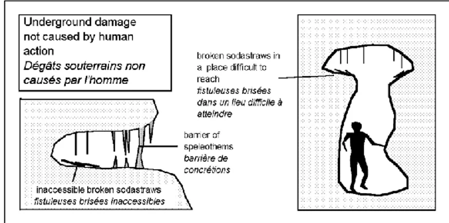
Plusieurs grottes ont été visitées dans l’Ouest Américain, entre la côte Californienne et les Montagnes Rocheuses, à la recherche de dégâts souterrains attribuables à des séismes. Dans les différentes cavités, des lieux peu accessibles (sommets d’escalades, passages très étroits, …) ont été inspectés pour éliminer au maximum l’hypothèse de dégâts humains (figure 1). Les observations les plus intéressantes ont été effectuées en Arizona et au Nouveau Mexique.
2. GROTTES DU SUD DE L’ARIZONA
Un séisme majeur à Sonora, au Mexique, a causé d’important dégâts en 1887, à proximité de la frontière avec l’Arizona et le Nouveau Mexique (figure 2 et 3). La magnitude supposée est de 7,2. L’intensité des dégâts près de Sierra Vista a été comprise entre VII et VIII (Stover et Coffman, 1993). Dans ce secteur, à Sutherland Peak dans les monts Huachuca, la grotte de S.P. Cave contient des concrétions variées dont de nombreuses fistuleuses. On peut observer d’importants dégâts affectant le concrétionnement: colonnes et coulées fracturées, piliers basculés. Ils résultent pour l’essentiel de tassements du substratum argileux de ces concrétions. En plusieurs points on peut cependant constater la présence au sol, de concrétions brisées. Certaines sont encore plantées verticalement dans l’argile ce qui indique un âge relativement récent. Ces chutes pourraient donc être attribuables au séisme de 1887. 3. GROTTES DU SUD DU NOUVEAU MEXIQUE
3. 1. Géologie des Monts Guadalupe et du secteur de Carlsbad. (d’après Jagnow. et al.,
1992)
L’élément directeur de la géologie de cette zone est l’unité de Guadalupe qui culmine à 2665 m au Pic Guadalupe. Cette unité est un vaste plateau sédimentaire incliné vers le nord-est où il s’ennoie sous la plaine de Carlsbad. Au Miocène, tout le secteur a connu une phase de plissement, suivie au début du Pliocène, d’une rupture de l’unité de Guadalupe à la faveur d’une importante faille nord-sud, verticale. Le compartiment Est de l’unité de Guadalupe a alors commencé à se soulever. Le mouvement se poursuit aujourd’hui. La vitesse est très importante, plusieurs centaines de mètres depuis 6 millions d’années (figure 6).
La région de Carlsbad possède de nombreuses et importantes cavités dont le réseau touristique de Carlsbad et la grotte de Lechuguilla. La plupart de ces grottes sont de véritables labyrinthes où les différents niveaux sont le reflet de différentes étapes du soulèvement de l’unité Est de Guadalupe. Malgré les traces évidentes d’une activité tectonique actuelle (failles actives), seuls des séismes mineurs ont été enregistrés depuis le début des mesures (figure 8).
3. 2. Visite des cavités
Près de Carlsbad, les grottes d’Endless, de Sand et de Mac Kittrick (Mac Kittrick Hills) sont des grottes labyrinthes dans lesquelles on observe de nombreuses chutes de concrétions. En plusieurs endroits, on peut voir des débris de fistuleuses, soudés au sol par de la calcite. Il en existe aussi de nombreux, libres, sur le sol, donc plus récents et provenant très vraisemblablement de saccages.
Dans la grotte de Sand, sur de la calcite fossilisant des fistuleuses, on peut voir une signature avec une date: 1917, montrant que la vitesse du concrétionnement est très lente et que les premières chutes sont antérieures à la présence des colons (figure 7).
Plus à l’ouest, la caverne de Carlsbad, grotte touristique, est le phénomène endokarstique majeur de ce secteur. Elle comprend trois niveaux de galeries de grande taille qui montrent, sur le sol, des fistuleuses brisées et recouvertes de calcite.
Beaucoup plus à l’ouest, dans le gouffre de Hidden on observe de nombreuses chutes de fines concrétions avec deux époques distinctes: une ancienne où les débris sont soudés au sol et une récente où les débris sont libres.
4. CONCLUSION
Une visite sommaire de la grotte de Sutherland Peak (SP cave), grotte bien préservée du vandalisme dans la région de Sierra Vista a montré des indices que l’on pourrait rattacher au séisme de 1887. De la même façon, dans la région de Carlsbad, l’étude succincte des grottes a permis l’observation générale d’indices convergeant vers la définition d’au moins un épisode sismique ancien qui a affecté la zone comprise entre le Mont Guadalupe et la ville de Carlsbad. La faille limitant à l’ouest les Monts Guadalupe, et dont le mouvement a causé l’importante surrection de ce secteur, est très certainement responsable de cette sismicité.
1. PRESENTATION AND METHOD
Speleothems are good indicators of paleoseismicity (Postpichl and al, 1991; Gilli, 1995 and 1996; Quinif, 1996; Forti, 1997 and 1998; Davenport, 1998). In certain conditions they break during an earthquake, and it is possible to see fragments on the soil of the caves (Becker, 1929; Gospodaric, 1977; Moser and Geyer, 1979, Gilli 1998a) and to obtain informations on the paleoearthquakes (Becker, 1929; Schillat, 1977, Agostini and al, 1994; Gilli, 1998b, Gilli and al, 1998).
We have looked for paleoseismicity signs in several caves in south western USA. Places with an important present seismic activity like California is, have in fact no cave, but we have obtained some results in south-eastern Arizona and south-eastern New Mexico, that are places with reduced present seismic activity.
In the USA the exploration of caves is quite recent. It began at the end of the 19th century when prospectors were looking everywhere, including caves, to find guano or gold. It is difficult to know if natives used to go underground as antique signs in deep caves are rare. For indian people, during the colonist period, the underground world was a sacred place haunted by ghosts and only the large cave entrances were inhabited. Meanwhile, it is possible that Archeoindians had different habits. Therefore, during our study, we have specially explored places that were difficult to reach (tops of climbs, very narrow passages, niches… ) to eliminate human caused damages (figure 1).
Figure 1: Location of signs in places protected against human vandalism.
Position des indices dans des endroits inaccessibles et préservés du vandalisme
2 . CAVES IN SOUTHERN ARIZONA 2. 1. Seismic history (figure 2 and 3 )
The mayor earthquake in Sonora (Mexico) on may 3rd, 1887, caused important damage in the USA, near the mexican border (figure 3). A reactivation of a 50 km long fault, 8 km south to Douglas has been described after this earthquake (DuBois and Smith, 1980). The supposed magnitude was 7.2. The damage intensity near Sierra Vista (that didn’t exist at that time) was between VII et VIII.
VIII in Box canyon: rocks and trees collapse in Ramsey peak. VII in Miller canyon: rocks collpases
VII in Fort Huachuca: fractures in buildings VII in Can canyon: big rocks collpases VII in Ash canyon: big rocks collpases
Tucson Phoenix Flagstaff Fredonia Yuma ARIZONA NEVADA CALIFORNIA MEXICO NEW MEXICO UTAH 32° 34° 36° 114° 112° 110° 100 km Sonora 1887 earthquake Sutherland Peak cave 7,0 - 7,4 5,5 - 5,9 5,0 - 5,4 4,5 - 4,9 VII VI intensity magnitude VI
Figure 2: Historical seismicity of Arizona and location of Sutherland Peak cave (S.P. cave) - From Stover and
Coffman (1993).
Sismicité historique de l’Arizona et localisation de la grotte de Sutherland Peak (S.P. cave) - Extrait de Stover et Coffman (1993).
Figure 3: The Sonora, 1887 earthquake isoseists and the location of Sierra Vista where Sutherland Peak cave is.
Isoséistes du séisme de 1887 à Sonora et localisation du secteur de Sierra Vista où se situe la grotte de Sutherland Peak. Extrait de Stover et Coffman (1993).
2. 2. S. P. Cave (Sutherland Peak cave)
SP Cave is a well decorated cave located on Sutherland peak, in Huachuca mounts near Sierra Vista. It contains an important quantity of speleothems, including shelters, helictites and sodastraws.
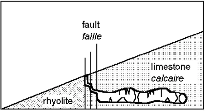
The cave is in a limestone lens included in a volcanic area (Hayes and Raup, 1968). It has functioned like a natural drain for the surrounding fractured rhyolites.
The contact between the rhyolite and the limestone is a fault with many parallel joints. A climb down in an open joint gives access to an horizontal phreatic maze level (figure 4). Several fractures affect the speleothems near these joints. These fractures were probably caused by a recent fault movement.
Figure 4: geological context of Sutherland Peak Cave (Sierra Vista) Contexte géologique de la grotte de Sutherland Peak (Sierra Vista).
In the horizontal level, damage affect the cave formations (broken flowstones and stalagmites, fractured pillars, tilted stalagmites). They result from clay subsidence below the speleothems. In some places the clay has been washed out by water circulation and the speleothem basis is well visible (figure 5). But in several places, small broken stalactites and sodastraws are present on the soil. Some of them are vertically stuck in the clay. The signs are recent as no new calcite is visible on them. These collapses could be the effect of the 1887 earthquake. The local intensity was VII and these evidences are similar to the effects observed in France after the February 18, 1996 earthquake (Ms 5.2 and intensity VI) that caused the collapse of sodastraws and small rocks (Gilli and al, 1998).
Figure 5: Fractures caused by subsidence in S.P. Cave
Fractures liées à des tassements dans S.P. Cave
3. CAVES IN SOUTHERN NEW MEXICO
3. 1. Geology of the Guadalupe Mountains and Carlsbad area (from Jagnow and
Rohwer-Jagnow, 1992) (figure 6).
The main element of the geological environment is Guadalupe block whose highest point is Guadalupe Peak (8.749 feet). The block, that contains limestone formations (Capitan limestone), deeps towards north-east, where it disappears beneath the plain of Carlsbad. It is bordered, on the west, by an important escarpment over salt lakes and on the south by another escarpment, the reef escarpment, over the Delaware evaporitic basin.
Figure 6: Sketch of Guadalupe Mounts with location of the studied caves.
Coupe schématique des Monts Guadalupe avec la position des grottes étudiées.
Capitan limestone is a permian reef that was probably covered with Mesozoic rocks. In the Miocene period this place began to arch. At Early Pliocene, a main fault line broke the block and the eastern part began to rise up until the present time (figure 6). The western escarpment results from this movement. It extended several hundred meters for the past 6 million years. There is no evidence of faulting in the reef escarpment area that results from a differential erosion process between the gypsum of Delaware basin and the Capitan limestone.
The area around Carlsbad contains many important limestone caves. Most of them are mazes with different levels and they usually contain gypsum deposit. Among them, are Lechuguilla, the deepest cave of USA, and Carlsbad cavern a world famous touristic cave. It is probable that these caves began to form during the Late Miocene or Early Pliocene when the Capitan reef started to arch and rise up. The Mesozoic cover eroded away, allowing the action of water on the limestone.
The water is now flowing towards Carlsbad springs in the Pecos River, but the functioning of water flow and caves digging, inside Capitan limestone, is difficult to understand as several phenomenon are involved:
- uplift movement,
- connections between the Delaware basin aquifer and the karstic aquifer, - presence of sulfuric acid (Hill, 1987).
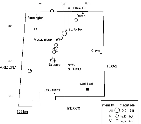
The importance of the western escarpment and the presence of active faults, prove that the uplift of the Guadalupe block is continuing today and the existence of different levels in the caves could indicate different steps in the uplift. At present time there is no evidence of a seismic risk in that area, as only small earthquakes have been recorded (figure 8). We have visited several caves near Carlsbad to search evidence of paleo-earthquakes.
3. 2. Evidences of speleothem collapses in the caves near Carlsbad
• Endless cave
This cave is a maze with three different levels. It can be an hydrothermal cave as it is located at the top of a limestone anticline which was probably covered with an impervious layer. There are many broken speleothems. It is possible to observe two kinds of signs:
- ancient broken sodastraws that are now soldered with calcite onto the flowstone, - more recent broken pieces, that are loose on the soil and were certainly broken by men. In some parts between the upper level and the entrance level, it is possible to observe collapsed limestone beds. The collapse have broken flowstone and big stalagmites.
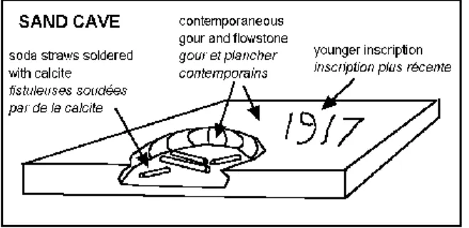
• Sand cave
Sand cave is also a maze located at the top of a hill. Unfortunately, in the early part of the century, the formations of the cave were destroyed to be sold at Carlsbad tourist shops. Meanwhile, two different ages of broken formations are visible in niches or inaccessible places, excluding a human cause. A signature with a date (1917) is engraved on a flowstone where some of the older collapsed sodastraws are included (figure 7). This observation indicates that the calcite formation is very slow and the age of the first collapse is older than the commercial activity.
Figure 7: Signs observed in Sand Cave (Mac Kitttrick hills, Carlsbad). The first collapses are older than 1917.
Indices observés dans Sand Cave. Les premières chutes sont antérieures à 1917.
• Mac Kittrick cave
Like the previous ones, Mac Kittrick cave is a maze located at the top of a hill. We also have observed in it, two periods of speleothem collapses.
• Carlsbad Cavern
In the whole cave, broken sodastraws, rocks collapses and fractures are visible. Some of these evidences have a speleogenetic origin:
- one of the most important collapse is Iceberg Rock, but the movement seems to have been a slow slip as the formations that were on the rock before the collapse, are not broken (figure 9),
- in the Colonel Boles Formations a large crack in the soil was caused by clay subsidence. But in several places, damage with a probable seismic origin are visible. For instance, between Crystal Spring Dome and the Rock of Ages, a little basin is full of ancient broken
stalactites. In Lower cave, broken sodastraws are now covered with calcite, forming hundreds cave pearls.
Figure 8: Historical seismicity of New Mexico and location of Carlsbad area. From Stover et Coffman (1993)
Sismicité historique du Nouveau Mexique et localisation de la zone de Carlsbad. Extrait de Stover et Coffman (1993).
Figure 9: Rock that has slowly dipped in Carlsbad Cavern.
Bloc ayant basculé lentement dans Carlsbad Cavern.
• Hidden cave.
Hidden cave is a small shaft located near the summit of the Guadalupe Mounts. The entrance is a vertical pit that conducts to two horizontal galleries. The cave is aligned on a fault line but no evidence of a recent movement was observed. In both galleries, many collapses are visible
and, as for the previous examples, two different ages may be observed. For the oldest collapse, the presence of several pieces located behind unbroken columns (figure 1) proves that the breaks were not caused by human action.
Hidden cave contains only short sodastraws and several stalactites have broken extremities with new calcite growth. It is mostly certain that this cave was affected by an important earthquake.
3. 3. Paleoseismicity
This place was recently inhabited and no data are available concerning its seismic history. This succint study of some caves near Carlsbad tends to prove the existence of an ancient seismic activity in the whole area between Guadalupe Mountains and the city of Carlsbad. The Western fault that causes the uplift of the Guadalupe block was probably responsible for some earthquakes in the past times. Unfortunately some of the caves have been partially destroyed by human activity. It would be very interesting to check the presence of two generations of broken sodastraws in well preserved caves. By comparison with the similar effects observed in the Barrenc du Paradet (Gilli and al, 1998) the magnitude of the paleo-earthquake could be close to 6.
4. CONCLUSION
The study of speleothems for paleosesimicity studies in the USA is a new approach that has to be developped with precautions. There are not enough caves in California for such studies. In Arizona some evidences in SP Cave could be attributed to the 1887 Sonora earthquake. In New Mexico, this short trip revealed that caves in Carlsbad area were probably affected by a paleoseismic activity. Most of the caves have been destroyed by human action and the observations have to be controlled in preserved caves. It would be worthwhile to check for the same evidences in other caves, like Lechuguilla near Carlsbad, or Kartchner Caverns near Sierra Vista, These caves are well protected against vandalism, but the permits are difficult to obtain.
As the seismic history of several places in the United States is too recent, seismic hazard is difficult to approach and cave studies could be a good tool. A project of nuclear waste disposal, is in progress near Carlsbad. The knowledge of the recurence and intensity of ancient seisms could be beneficial. These informations are certainly recorded in the caves of Guadalupe Mountains and Carlsbad area.
Acknowledgements:
Coronado National Forest (Arizona), Lincoln National Forest (N. Mexico), Bureau of Land Management (Carlsbad), Carlsbad Caverns National Park.
REFERENCES
Agostini S., Forti P., Postpichl D., 1994. Gli studi sismotettonici e paleosismici effetuati nelle grotta del Cervo di Petrasecca nel periodo 1987-1991, Mem. Ist. Ital. Speleol., ser. 2, n°5, p. 97-104
Becker H.K., 1929. Höhle und Erdbeben: Mitt. über Höhlen, u. Karstf., n° 1-4, p. 130-133 Bini A., Quinif Y., Sules O., Uggeri A., 1992. Les mouvements tectoniques récents dans les grottes du Monte Campo dei Fiori (Lombardie Italie), Karstologia n° 19
Camelbeeck T., 1998. Speleothems as palaeoseismic indicators: the point of view of a seismologist, Speleochronos h.s. Coll Han 98 Karst & Tectonics 1998, p. 41-44
Davenport C.A., 1998. Karst as a record of Palaeoseismicity, Speleochronos h.s. Coll Han 98 Karst & Tectonics 1998, p. 41-44
DuBois S. and Smith A., 1980. The 1887 earthquake in San Bernardin Valley, Sonora, spec. paper 3, Arizona bur. of geol. & min. tech. Univ. of Arizona, Tucson, 112 p.
Forti P., 1997. Speleothems and Earthquakes, in Hill C. and Forti P. (eds) Cave minerals of the world. Nat. Spel. Soc. p. 284-285
Forti P., 1998. Seismotectonic and paleosismic studies from speleothems, Speleochronos h.s. Coll Han 98 Karst & Tectonics 1998, p. 79-81
Gilli E. , 1995. Recording of earth movements in karst, 5th Int. Conf. Seism. Zonation. oct. 17,18,19,1995 Nice. AFPS. EERI. Ouest Edit. Nantes p. 1305-1314
Gilli E., 1996. Effets des séismes dans l’endokarst. Application aux études de sismicité historique, in Géomorphologie, risques naturels et aménagement. Hommage à M. Julian. Lab Rev. An. Spat. Raoul Blanchard n°38-39. Nice. pp.121-132
Gilli E., 1998 a. Approche de la paléosismicité de Monaco par l’étude d’un plancher stalagmitique de la Grotte de l’Observatoire, Proc. Coll. Han 98, Tectonique, karst et séismes. Speleochronos h.s. 1998, Centre Belg. Etud. Karstol. et AFK. 4 p.
Gilli E., 1998 b. Bilan des recherches du CEK sur l’enregistrement naturel des effets sismo-tectoniques dans l’endokarst,Proc. Coll. Han 98, Tectonique, karst et séismes. Speleochronos h.s. 1998, Centre Belg. Etud. Karstol. et AFK. 4 p
Gilli E., Levret A., Sollogoub P., Delange P., 1998. Recherches sur le séisme du 18 février 1996 dans les grottes de la région de Saint-Paul-de-Fenouillet (Pyrénées Orientales, France), Proc. Coll. Han 98, Tectonique, karst et séismes. Speleochronos h.s. 1998,Centre Belg. Etud. Karstol. et AFK. 4 p.
Gospodaric P., 1977. Collapsing of speleothems in Postojna cave system, Proc. 7th Int. Spel. Congress, Sheffield, p. 223-240
Hayes P. and Raup R., 1968. Geological map of the Huachuca and Mustang moutains southeastern Arizona, Geol. map I-509, USGS, Washington
Hill C., 1987. Geology of Carlsbad cavern and other caves in the Guadalupe Mountains, New Mexico and Texas. New Mexico Bur. of Mines & Min. Ress. Bull 117
Jagnow D.H. et Rohwer-Jagnow R., 1992. Stories from stones. The geology of the Guadalupe mountains, Carlsbad Caverns. Guadalupe Mountain assoc. Carlsbad New Mexico. 40 p. Moser M., et Geyer M., 1979. Seismospeläologie-Erdbebenzerstörungen in Höhlen am Beispiel des Gailoches bei Oberfellendorf (Oberfranken, Bayern), Die Höhle, v. 30, no 4, p. 89-102
Postpichl D., Agostini S., Forti P., et Quinif Y., 1991. Paleosismicity from karst sediments: the Grotta del Cervo cave case study (Central Italy), Tectonophysic, no. 193, p. 33-34
Quinif Y., 1996. Enregistrement et datation des effets sismo-tectoniques par l’étude des spéléothèmes, Ann. Soc. Geol. Belg. n°119, p. 1-13
Schillat B., 1977. Conservation of tectonic waves in the axes of stalagmites over long periods, Proc. 7th Int. Cong. Speleol. Sheffield, p. 377-379.
Stower C.W. et Coffman J.L., 1993. Seismicity of the United States 1568-1989 (revised), USGS prof. paper 1527