HAL Id: hal-03257427
https://hal.archives-ouvertes.fr/hal-03257427
Submitted on 11 Jun 2021
HAL is a multi-disciplinary open access
archive for the deposit and dissemination of
sci-entific research documents, whether they are
pub-lished or not. The documents may come from
teaching and research institutions in France or
abroad, or from public or private research centers.
L’archive ouverte pluridisciplinaire HAL, est
destinée au dépôt et à la diffusion de documents
scientifiques de niveau recherche, publiés ou non,
émanant des établissements d’enseignement et de
recherche français ou étrangers, des laboratoires
publics ou privés.
Copyright
Geodynamics of the northern Andes: Subductions and
intracontinental deformation (Colombia)
Alfredo Taboada, Luis Rivera, Andrés Fuenzalida, Armando Cisternas, Hervé
Philip, Harmen Bijwaard, José Olaya, Clara Rivera
To cite this version:
Alfredo Taboada, Luis Rivera, Andrés Fuenzalida, Armando Cisternas, Hervé Philip, et al..
Geo-dynamics of the northern Andes: Subductions and intracontinental deformation (Colombia).
Tec-tonics, American Geophysical Union (AGU), 2000, 19 (5), pp.787-813. �10.1029/2000TC900004�.
�hal-03257427�
TECTONICS, VOL. 19, NO. 5, PAGES 787-813 OCTOBER 2000
Geodynamics of the northern Andes'
Subductions and intracontinental deformation (Colombia)
Alfredo Taboada,
l'z Luis A. Rivera,
TM
Andr6s
Fuenzalida,
5 Armando
Cisternas,
4
Herv6
Philip,
1 Harmen
Bijwaard,
• Jos60laya,
5 and
Clara
Rivera
5
Abstract. New regional seismological data acquired in
Colombia during 1993 to 1996 and tectonic field data from the Eastern Cordillera (EC) permit a reexamination of the complex geodynamics of northwestern South America. The effect of the
accretion of the Baud6-Panama oceanic arc, which began 12 Myr
ago, is highlighted in connection with mountain building in the EC. The Istmina and Ibagu6 faults in the south and the Santa Marta-Bucaramanga fault to the northeast limit an E-SE moving continental wedge. Progressive indentation of the wedge is
absorbed along reverse faults located in the foothills of the
Cordilleras (northward of 5øN) and transpressive deformation in
the Santander Massif. Crustal seismicity in Colombia is
accurately correlated with active faults showing neotectonic morphological evidences. Intermediate seismicity allows to identify a N-NE trending subduction segment beneath the EC, which plunges toward the E-SE. This subduction is interpreted as a remnant of the paleo-Caribbean plateau (PCP) as suggested by geological and tomographic profiles. The PCP shows a low-angle
subduction northward of 5.2øN and is limited southward by a
major E-W transpressive shear zone. Normal oceanic subduction of the Nazca plate (NP) ends abruptly at the southern limit of the Baud6 Range. Northward, the NP subducts beneath the Choc6 block, overlapping the southern part of the PCP. Cenozoic
shortening in the EC estimated from a balanced section is ~120
km. Stress analysis of fault slip data in the EC (northward of
4øN), indicates an ~E-SE orientation of c•l in agreement with the PCP subduction direction. Northward, near Bucaramanga, two stress solutions were observed: (1) a late Andean N80øE
compression and (2) an early Andean NW-SE compression.
1. Introduction
The Andes of Colombia, Venezuela, and Ecuador represent
the northern termination of the Andean belt, which extends for
•UMR 5573, Laboratoire de G6ophysique, Tectonique et S6dimentologie, CNRS, Universit6 Montpellier II, Montpellier, France.
ZDepartamento de Ingenieria Civil, Facultad de Ingenieria, Universidad de Los Andes, Bogotfi.
3Seismological Laboratory, California Institute of Technology, Pasadena.
4Institut de Physique du Globe, Universit6 Louis Pasteur, Strasbourg, France.
$Instituto de Investigaciones en Geociencias, Mineria y Quimica, Bogotfi.
6Vening Meinesz School of Geodynamics, Institute of Earth Sciences,
Utrecht University, Netherlands.
Copyright 2000 by the American Geophysical Union.
Paper number 2000TC900004.
0278-7407/00/2000TC900004512.00
more than 9000 km along the western margin of South America
[M•gard, 1987]. Intracontinental deformation in the northern
Andes results from the complex interaction between three
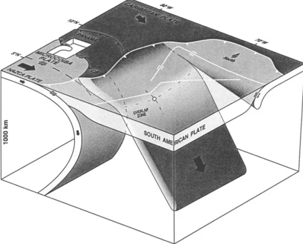
lithospheric plates (Figure 1). The Nazca oceanic plate is converging eastward at 6 cm/yr relative to northwestern South
America (NWSA); the Caribbean plate is moving at 1-2 cm/yr to
the E-SE relative to NWSA [Freyrnueller et al., 1993; Kellogg and Vega, 1995].
The Eastern Cordillera (EC) of Colombia is a N-NE trending intracontinental orogenic belt extending for 750 km from the
Ecuadorian to the Venezuelan border. It is located in the eastern
part of the northern Andes, where it rises abruptly above the
lowlands of the South American craton. The medium height of
the chain is close to 3000 m (Altiplano Cundiboyacense), with
summits reaching 5500 m.
The genesis of the EC has been a matter of long debate, and
various deformation models at the lithospheric scale have been
proposed for the northern segment:
1. The oceanic subduction type models suggest that the
Caribbean plate subducts beneath the EC [e.g., Pennington, 1981]. In this particular model the North Andean block (corresponding to the Andean ranges of Ecuador, Colombia, and Venezuela) is moving toward the NE relative to the South American plate, along a transpressive system of faults following the front of the EC [Pennington, 1981; Freyrnueller et al., 1993; Kellogg and Vega, 1995]. Other authors have suggested that the Nazca plate (and not the Caribbean) subducts beneath the EC [e.g., van der Hilst and Mann, 1994].
2. The low-angle thrusting models propose that faulting and
folding in the cordilleran crust are the consequence of the
reactivation of an east vergent detachment along the middle or
lower crust [Dengo and Covey, 1993; Cooper et al., 1995]. These models suggest that the gently dipping detachment extends
beneath the Middle Magdalena basin and Central Cordillera and
branches off from the Nazca subduction zone beneath the
Western Cordillera of Colombia (Figure 1 and Plate 1).
3. The intracontinental deformation type models propose that the northern segment of the EC may result from subduction of the continental lithospheric mantle (CLM) beneath the mountain range [Colletta et al., 1990]. In this particular model the direction of continental subduction has not been determined, and two possibilities have been put forward (east or west dipping subduction).
Some of these authors have suggested that the collision
between the Panama-Choc6 terrane and NWSA, which occurred at about 12 Ma [Duque-Caro, 1990b], caused uplift and shortening in the EC [Dengo and Covey, 1993; Cooper et al., 1995; Kellogg and Vega, 1995].
On the basis of new seismological, tectonic, and tomographic data, we reevaluate the seismotectonics of Colombia and the
788 TABOADA ET AL.: GEODYNAMICS OF THE NORTHERN ANDES 10 COCOS Plate I I cm/y \ Bahama Banks 1-2 cm/y
North American Plate
•
o
Plate
.,•
1-2 cm/y ._ I 6ow500
km I
20N - \ o \ o... ..?-
Nazca Plate
... ' ... -,-.,5-tSouth American Plate
• Reverse fault
• Strike-slip fault
• Normal fault
• Fold axes ½• Spreading ridge i•')):/•'•.! Oceanic ridge (rise) 0,4 - 1,5 km ... Magnetic anomaly
1,5 - 3,0
_ _,,, Oceanic
basins
3,0- 5,0
o Calc-alkaline
ß Alkaline volcanoesvolcanoes
>5,0 ,,• ... -- Bahama BanksBucaramanga Seismicity Nest
Plate velocity relative to South American Figure 1. Neotectonic plate setting of the northern Andes and the Caribbean region indicating the main active fault systems. The continental deformation in Colombia is the result of the relative motions of the three main plates (Nazca, South American, and Caribbean). Map sources are indicated in Plate 1. G, Guayaquil; Q, Quito; B, Bogotfi;
C, Caracas; CB, Choc6 block; EC, Eastern Cordillera; MB, Maracaibo block; MR, Malpelo Ridge; CR, Coiba
Ridge; BR, Barracuda Ridge; TR, Tibur6n Rise; HE, Hess Escarpment; SMB, Santa Marta-Bucaramanga fault; Lan, Lesser Antilles Arc.
geometry
of subduction
zones
beneath
NWSA. This paper
examines the tectonic structure of the northern segment of the EC
(which extends from the south of Tunja to Bucaramanga) and its
relationship
with intermediate
seismicity
located
beneath
the
range
(Plate
1). Seismological
data
include
relocated
events
from
the National Seismological Network of Colombia, recordedbetween June 1993 and December 1996. Tectonic data include
field observations on structural geology and geomorphology
concerning
active faulting.
Tomographic
sections
across
the
northern Andes were obtained from a global model which aims to
solve
lithospheric-scale
structures
in the mantle
[Bijwaard
et al.,
19981.
In section 2 we shall summarize and discuss the principal
geologic
and
tectonic
features
of the northern
Andes.
Section
3
presents
a geodynamic
model
of the Colombian
Andes,
based
on
geologic
data and tomographic
profiles.
Sections
4 and 5 are
devoted to the analysis of the seismicity pattern of Colombia and
the seismotectonics of the Eastern Cordillera: several
seismological
and
structural
cross
sections
are presented,
as well
as a stress field map calculated from microtectonic analysis offault slip data.
2. Tectonic Setting of the Northern Andes
and the CaribbeanIntracontinental deformation in the northern Andes is
characterized by mountain chains associated with large-scale reverse and strike-slip faults. The direction of ranges is generally N-S to NE-SW, compatible with the convergence directions
between
plates
(Figure
1 and
Plate
1). The present
deformation
pattern
is marked
by the reactivation
of large-scale
fault zones,
inherited from previous tectonic phases. Eastward movement ofTABOADA ET AL.: GEODYNAMICS OF THE NORTHERN ANDES 789
the Nazca plate is partly absorbed along the east dipping subduction zone beneath NWSA and along several continental fault systems that are subparallel to the mountain chains.
2.1. The Andes of Ecuador
The Andean chain in Ecuador displays two main ranges
roughly parallel to the oceanic trench, separated by the Inter- Andean Depression (located eastward from Quito) (Figure 1).
The Western Cordillera of Ecuador is composed of oceanic rocks accreted to the continent along a major suture zone, during late
Cretaceous and early Tertiary [e.g., Aspden and Litherland,
1992]. The Ecuadorian Inter-Andean Depression corresponds to an allochthonous block characterized by an uppermost Pliocene-
Quaternary basin which is located between two N-S trending
reverse basement faults [Lavenu et al., 1995]. Reverse faults
exhibit opposite thrusting vergence creating a "push down" type compressional basin and are connected southward to a major right-lateral fault which strikes N30øE (located eastward from Guayaquil) (Figure 1) [e.g., Winter et al., 1993]. Right-lateral movement is progressively absorbed along E-NE trending normal faults of the Gulf of Guayaquil pull-apart basin [Winter et al., 1993]. The overall fault geometry resembles an extensional horsetail with a restraining bend corresponding to the Inter-
Andean Depression.
The Eastern Cordillera of Ecuador (Cordillera Real) is a
metamorphic belt which overthrusts the sub-Andean zone located eastward, along the North Andean Frontal fault [e.g., Aspden and
Litherland, 1992]. The Cordillera Real is limited by two main
reverse faults with opposite vergence. The sub-Andean zone is characterized by a series of eastward verging imbricated slices of sedimentary and volcanic rocks [Baldock, 1982].
2.2. The Andes of Colombia
The Colombian Andes between latitudes IøN and 8øN display
three main ranges, the Western, Central, and Eastern Cordilleras, which merge southward into a single range (Plate 1). The Western and Central Cordilleras are aligned parallel to the Pacific coast and are separated by the Cauca-Patia Intermontane Depression (CPID). The Eastern Cordillera diverges progressively from the Central Cordillera along a N-NE direction. The Magdalena River flows northward along the wide valley located between these two ranges (Plate 1). The nature and composition of the three Cordilleras are substantially different, each one resulting from distinct tectonic processes that affected NWSA during the Mesozoic and Cenozoic (Table 1).
The Romeral fault system (RFS), which extends along the boundary between the CPID and the Central Cordillera,
subdivides the Colombian Andes into two main regions: The
"Occidente" and the "Oriente" located west and east of the RFS, respectively. This fault system joins the Ecuadorian suture zone
farther south as mentioned in section 2.1.
The evolution and structural style of the "Occidente" has been fashioned by convergence between the proto-Pacific or proto- Caribbean plate and NWSA. Mountain ranges located to the west of the RFS are composed of oceanic rocks accreted to the western margin of South America during the Mesozoic and Cenozoic [e.g., McCourt et al., 1984; Pindell and Barrett, 1990; Restrepo- Pace, 1992; Kellogg and Vega, 1995]. During Cretaceous and early Cenozoic the Farallon plate approached NWSA from the
SW leading to oblique subduction along the old continental
margin and to large dextral movements along the RFS [Gr6sser, 1989]. The breakup of the Farallon plate into the Nazca and
Cocos plates at 25 Ma reoriented convergence between NWSA and the Farallon / Nazca plate from a NE-SW to an E-W
direction [Lonsdale and Klitgord, 1978; Pilger, 1983]. Convergence has remained approximately E-W until present,
leading to transpressive deformation along continental faults trending N-NE in southwestern Colombia. The Serrania del Baud6 is a narrow range located to the west of the Western Cordillera. It is an exotic piece of Central America, which was
part of an island arc that extended toward Panama (Figure 2). The
island arc was linked to subduction of the Pacific plate beneath
the southwestern margin of the proto-Caribbean plate [e.g., Wadge and Burke, 1983]. The eastward movement of the
Caribbean plate with respect to NWSA during early and middle Miocene was partly absorbed by subduction of oceanic lithosphere beneath the northwestern comer of South America [Pindell and Barrett, 1990]. Subduction led to the closure of the
oceanic domain located in between the Baud6-Panama island arc
and the Western Cordillera. This oceanic domain corresponded to the southern part of the paleo-Caribbean plate, and it was
separated from the Nazca plate by an approximately east-west trending transform fault (Figure 2a). Finally, collision between
the exotic block and NWSA occurred toward Middle Miocene
time (12 Ma) [Duque-Caro, 1990b]: the eastern part of the island arc (including the Baud6 range and northeastern Panama), known
as the Choc6 block (CB), was accreted to the northwestern flank
of the Western Cordillera. The collision between the western
Panama island arc and South America occurred later, mainly during late Miocene and Pliocene [Mann and Corrigan, 1990].
The final closure of the Pacific-Caribbean gateway occurred
during the late Pliocene. Duque-Caro [1990a] proposes that the
Panamanian isthmus became completely emergent between 3.7 and 3.1 Ma, whereas Keller et al. [1989] estimate that the closure of the isthmus began at 2.4 Ma, with final closure at 1.8 Ma.
The CB is limited by active fault systems such as the Uramita
fault zone (UFZ) to the east and the Istmina deformed zone (IDZ)
to the south (Plate 1) [Duque-Caro, 1990b; INGEOMINAS,
1997]. The IDZ is characterized by transpressive right-lateral
faults trending E-NE, such as the Garrapatas fault (GAF), which shows neotectonic activity [Paris and Romero, 1994; Guzmdn et al., 1998]. The UFZ is conjugate, trending to the N-NW and exhibiting a transpressive left-lateral movement. The accretion of the CB is contemporary with the onset of the major "Andean" tectonic phase in the EC, which began at 10.5 Ma and continued during Plio-Quatemary time [e.g., Cooper et al., 1995; Kellogg and Vega, 1995; Taboada et al., 1998].
Late Tertiary and present deformation along the RFS is characterized by east dipping reverse and strike-slip faults which
are part of a larger
west
vergent,
basement-involved
fold and
thrust belt [Alfonso et al., 1994; Parœs and Romero, 1994; Guzmdn et al., 1998]. The RFS trends N-NE and shows a right-lateral component
in southwestern
Colombia (Plate 1).
Northward of latitude 4øN it shows a left-lateral component
which is probably associated with E-SE convergence between the
Choc6 block and NWSA. The Armenia 1999 earthquake,
earthquake
13 in Table 2, clearly
illustrates
the left-lateral
movement along the RFS: the focal mechanism obtained from the790 TABOADA ET AL.: GEODYNAMICS OF THE NORTHERN ANDES .,, I, LI I 0 0 E . ,..., o o 'Z 3 .w•'u.d
TABOADA ET AL.' GEODYNAMICS OF THE NORTHERN ANDES 791
•6oo
,-•oo'•....••_
-1.0% 65 ø +1.0% 80* 7,5* 70* 65* 85 ø W "' oP N" --" 70' 65 ø A BPlate 2. Tomographic
sections
across
the northern
Andes
and
hypothetical
interpretations
in terms
of subduction
792 TABOADA ET AL.: GEODYNAMICS OF THE NORTHERN ANDES
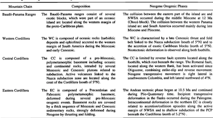
Table 1. Age and Origin of the Main Ranges and Cordilleras in Colombia
Mountain Chain Composition Neogene Orogenic Phases
Baud6-Panama Ranges
Western Cordillera
Central Cordillera
Eastern Cordillera
The Baud6-Panama ranges consist of several exotic blocks, which were part of an oceanic island arc located along the western margin of the proto-Caribbean plate.
The WC is composed of oceanic rocks (turbiditic deposits and ophiolites) accreted to the western
margin of South America during the Mesozoic and early Cenozoic.
The CC is composed of a pre-Mesozoic, polymetamorphic basement including oceanic and continental rocks, intruded by several Mesozoic and Cenozoic plutons related to
subduction. Active volcanoes linked to the
Nazca subduction zone are located along the
crest of the Cordillera (south of 5øN).
The EC is composed of a Precambrian and Paleozoic polymetamorphic basement, deformed during several pre-Mesozoic orogenic events. Basement rocks are covered by a thick sequence of Mesozoic and Cenozoic sedimentary rocks, strongly deformed during Neogene by thrusting and folding.
The collision between the eastern part of the island arc and NWSA occurred during the middle Miocene at 12 Ma
(Choc6 block). The collision between the western Panama
island arc and South America occurred mainly during late
Miocene and Pliocene.
The WC is characterized by a late Cenozoic thrust and fold
belt linked to the Nazca subduction (south of 5øN) and to the accretion of exotic Caribbean blocks (north of 5øN).
Neotectonic deformation is observed along both foothills. The CC is limited by reverse fault systems located along the
foothills, which root beneath the range. The Romeral fault, located along the western flank, has been activated since Oligocene, combining strike-slip and reverse movement: Neogene transpressive movement is right lateral in
southwestern Colombia, and left lateral northward of 4øN.
The Andean tectonic phase began at 10.5 Ma and continued during Plio-Quaternary time. Incipient transpressive deformation in the flanks occurred during the Paleogene. Intracontinental deformation in the northern EC is closely related to accretion/collision episodes along the active margin of NWSA and to shallow subduction of the PCP
beneath the Cordilleras (north of 5.2øN).
NWSA, northwestern South America; WC, Western Cordillera; CC, Central Cordillera; EC, Eastern Cordillera; PCP, paleo-Caribbean plateau.
Harvard centroid moment tensor (CMT) file is coherent with a
left-lateral N-NE active fault obseved in the field (the strike, dip, and rake of the focal planes are 8ø/65ø/-21 ø and 107ø/71ø/-153ø, respectively). This result is coherent with the convergence direction between Panama and Bogotfi determined by Global Positioning System (GPS) measurements [Kellogg and Vega, 1995]. Quaternary tectonic activity in the RFS is moderate to high, as shown by shallow seismicity and neotectonic geomorphologic features observed along the western flank of the Central Cordillera up to latitude 8øN (Nazca plate influence zone)
[Paris and Romero, 1994]. The RFS is generally assumed to
extend northward between latitudes 8øN and 11øN across the Colombian Caribbean region for more than 300 km in a N-NE
direction (Plate 1). Nevertheless, fault traces are less visible at the surface in this area, and neotectonic activity is very low. The
paleosuture subdivides the Caribbean region into two principal domains [Duque-Caro, 1984]: (1) a continental domain located eastward of the RFS, characterized by Paleozoic and Mesozoic
basement rocks, and (2) an oceanic domain west of the fault,
characterized by basement and sedimentary rocks of oceanic affinity. A thick sedimentary cover of Tertiary marine sediments and Quaternary fluvial and lacustrine deposits overlies the continental rocks. Quaternary sediments are located within the lowlands corresponding to the Lower Magdalena and Lower
Cauca floodplains.
The most important tectonic structures observed to the west of the RFS in the Caribbean margin are the San Jacinto and Sinfi thrust and fold belts composed of deformed oceanic rocks [e.g.,
Case et al., 1984]. The Sinfi- San Jacinto terranes resulted from
two progressive accretionary episodes of deformation and emergence, during the early Cenozoic (San Jacinto belt) and late
Cenozoic (Sin6 belt) [Duque-Caro, 1984]. The San Jacinto belt is characterized by three moderate ridges, which extend northward for 360 km along a discontinuous range. The thick sedimentary sequence observed in the area consists of upper Cretaceous and lower Tertiary deep-sea rocks, deformed by compressive tectonics [Duque-Caro, 1984]. Large-scale anticlines and thrust faults trending N-NE and with vergence toward the Caribbean
sea have been described. These structures are mostly linked to
convergence between the Caribbean plate and NWSA. The
eastern flank of the thrust belt is covered with Quaternary fluvio- lacustrine deposits.
The Sinfi thrust belt is located between the Sinfi fault to the east and the South Caribbean Marginal fault to the west (Plate 1). This younger belt extends parallel to the Colombian Caribbean margin along more than 500 km. It comprises several anticlines located inland and progressively continues offshore along the continental shelf and the inner slope of the active Caribbean margin [e.g., INGEOMINAS, 1997]. The deformation pattern is
similar to the San Jacinto thrust belt and displays west vergence fault-bend folds within a thick cover of Neogene sediments
[Duque-Caro, 1984]. The internal structure of these belts is compatible with a low-angle basal friction accretionary prism. Active folding along the toe of the prism has been interpreted in terms of low-angle subduction of the Caribbean plate beneath northwestern Colombia [Toro and Kellogg, 1992].
The Colombian "Oriente" consists of the Central and Eastern
Cordilleras, which lie at or near the western margin of the
Precambrian Guyana shield. Rocks observed in these mountain ranges have experienced several phases of tectonic deformation
as a result
of plate
motion
since
the breakup
of Pangea
[e.g.,
M•gard, 1987].TABOADA ET AL.: GEODYNAMICS OF THE NORTHERN ANDES 793
*
.
Caribbean •1•
Plate 1'2
C/n/y
10cocos
/_^_R
b'
Plate • •
/---
500 km •
Figure 2. Schematic tectonic reconstructions of the northern Andes and the Caribbean (a) at 20 Ma and (b) at present time. Reconstructions illustrate the geodynamic pattern before and after the collision of the Baud6-Panama island arc (BPA; dark shaded area), which began at 12 Ma. Stars indicate approximate location of active volcanism;
cross sections a-a' and b-b' are illustrated in Figure 3. EC, Eastern Cordillera; AR, Abandoned Ridge.
The Central Cordillera (CC) is composed of a pre-Mesozoic, polymetamorphic basement corresponding mainly to a disrupted, medium- to low-pressure, metamorphic belt including rocks of
both oceanic and continental character [McCourt et al., 1984].
Basement rocks (largely Paleozoic) are intruded by several
Mesozoic and Cenozoic plutons related to the subduction of
oceanic lithosphere underneath the Andean chain. Recent
magmatic activity is concentrated along the crest of the Central Cordillera, where active volcanoes with summits attaining heights of 5750 m are located.
The western flank of the CC is steeper than the eastern flank and has been uplifted by transpressive movement along faults
dipping eastward, which belong to the RFS (for instance, the 1999 Armenia earthquake). The eastern flank of the CC is
characterized by west dipping reverse faults located along the foothill of the Magdalena valley. Strike-slip right-lateral faults
trending E-NE cut across the CC and the Magdalena valley between latitudes 4øN and 5øN (e.g., the right-lateral Ibagu6 faul0 [Vergara et al., 1996]. These strike-slip faults are parallel
and form an "en echelon" system with the Garrapatas fault zone.
Thus they are probably associated with the accretion of the CB
(Plate 1).
2.3. The Eastern Cordillera
The EC is characterized by a Precambrian and Paleozoic
polymetamorphic basement, deformed during several pre-
Mesozoic orogenic events. Basement rocks are covered by a
thick sequence of Mesozoic and Cenozoic sedimentary rocks, strongly deformed during Neogene time by thrusting and folding [e.g., Irving, 1971]. Jurassic and Cretaceous sedimentary rocks were deposited within large basins whose origin is possibly
794 TABOADA ET AL.' GEODYNAMICS OF THE NORTHERN ANDES _ 6øN C • .D
o•
- 4ON0
0
--t
•'
- 2ONO0
WC o i75øW
•
73øW
o
o• • or'
•'
O•
'
•
O8)
'7 .' 12 •'11
c ß ¸ o œ C' cc<"¸
EC •
2•N - LB ! Venezuela . SøN _ Colombia 73øW ,,, , ,! , [ ... _,,,, ,.,,=Depth (km)
Magnitude
0-30 © 330-60
4
60-90 5 90-120120-150
>1506 [
Plate 3. Seismicity of Colombia during the period June 1993 to December 1996, relocated from data of the
National Seismological Network of Colombia (NSNC). White diamonds are seismic stations; white and gray stars represent shallow and intermediate strong earthquakes during the last decade, numbered according to Table 2. LB, Llanos basin; UG, Uraba Gulf.
TABOADA ET AL.: GEODYNAMICS OF THE NORTHERN ANDES 795 o SLR ¸ ,O I t % 7øN A CC O • 7ON -
.•
3• ../
•'
72øW
I
30
.• • _•
ß
33
Depth (km)
.
, I •
B •/
32
•
•60
'
c'
>6o
, • og
ß
•
agnitude 0-30
9•120
' 3•0•x•
ø•
ß 3 0 6•90
• •• •11avi•ncio
• 12•150
•
'
73•
• >150
Plate 4. Seismicity (June 1993 to December 1996), focal mechanisms, and tectonics of the northern half of the
Eastern Cordillera. Orange circles correspond to crustal seismicity; green and blue circles correspond to
intermediate seismicity. Active faulting and folding and abbreviations are shown with the same symbols as those in Plate 1. Vertical cross sections A-A' to D-D' of Figure 4 and Plates 4 and 5 are indicated by thick gray lines. The upper right inset shows mechanisms associated with the Bucaramanga nest. Mechanisms correspond to Harvard
796 TABOADA ET AL.: GEODYNAMICS OF THE NORTHERN ANDES
related
to (1) continental
rifling
since
Triassic,
as a consequence
of an extensional tectonic regime in NWSA, linked to the separation between North America and South America [Mojica et
al., 1996], or (2) back arc basin extension located east of the
Central Cordillera, as a consequence of subduction of the Farallon oceanic plate beneath NWSA.
Graben systems extended in a N-NE direction, from the
Cordillera Real in Ecuador all through the EC of Colombia, the amount of extension increasing northward [e.g., Etayo et al., 1969; Mojica et al., 1996]. The direction of grabens changes to N-NW in the northern end of the EC: namely, it becomes parallel to the Santander Massif (SM). From here the graben system branches into at least three independent basins trending NE: one parallel to the Mf•rida range, another one at the present location of the Maracaibo lake, and the last along the Perijh range, at the
limit between Colombia and Venezuela (Plate 1). These three
branches terminate abruptly against the east-west Oca strike-slip fault. Mesozoic basins located south of the Oca fault were formed on thinned continental crust subjected to a mean E-SE trending extension and are oriented accordingly. Other east-west trending
Mesozoic grabens have been described north of the Oca fault.
Later on, compressive Cenozoic deformation reactivated some of the normal faults that bounded the Mesozoic basins, inverting their sense of movement [e.g., Colletta et al., 1990, 1997]. The two main inherited fault directions in the EC correspond to NE- SW and N-S trending faults. Tectonic inversion of basement faults created faulting and folding of the thick sedimentary sequences (mostly marine) deposited in the Mesozoic basins.
At least three distinct pre-Andean transpressive deformation phases have been observed in the Magdalena valley and the EC during the Paleogene [e.g., Cooper et al., 1995; Casero et al., 1997]: (1) a Late Cretaceous - early Paleocene deformation phase mostly present in the Upper Magdalena valley and the southern segment of the EC, which was linked to the final accretion of oceanic crustal fragments of the Western Cordillera [McCourt et al., 1984], (2) an early to middle Eocene tectonic phase, which created west vergent thrusting and folding in the Middle Magdalena, and (3) a lowermost Oligocene compressire phase characterized by thrusting and folding along west vergent tear faults in the western flank of the EC [Branquet et al., 1999]. The late Eocene-early Oligocene tectonic phase also created east vergent thrusting along the eastern foothill of the EC [e.g., Corredor, 1997]. During these phases, transpressive right-lateral deformation probably occurred along the Romeral and Salinas fault systems as a result of oblique convergence between the paleo-Caribbean plate and NWSA. The accretion of the San Sacinto terrane, which occurred during Paleogene [Duque-Caro,
1984], seems to be well correlated with the Eocene and
Oligocene transpressive phases mentioned previously.
The EC widens progressively northward showing different tectonic styles and a varying morphology. The southern segment is a narrow range with moderate relief, not exceeding 2500-3000 m along the mountain crest (Plate 1). Major right-lateral faults trending NE displace basement rocks (e.g., Algeciras - Altamira fault system) [Vergara, 1996]. Reverse faulting is observed in restraining bends and in N-NE trending faults located along the
foothills.
The central segment encloses the "Sabana de Bogoth," a high plateau located at 2700 m. Reverse faults dipping toward the range are observed in both foothills (Plate 1). Major uplift in the
Sabana de Bogoth area occurred between 3 and 5 Ma as revealed
by palinologic data from Pliocene deposits [Helmens and Van der Hammen, 1995]. However, pre-Pliocene compressive deformation has been identified in the EC from stratigraphic and tectonic analysis. Neogene and, in particular, Miocene
compressive deformation is visible in the axial zone of the EC,
where folded sedimentary rocks are overlain by tilted Pliocene deposits with a pronounced angular unconformity (e.g., Tunja
area [Taboada et al., 1996]).
Compressional deformation and thrusting along "en echelon"
reverse faults located in the eastern foothills (Servith- Santa
Maria (SSM), Guaichramo (GF), Yopal, and EC Frontal faults) are mainly associated with collision and convergence of the
Panama-Baud6 island arc located to the west. These faults are
known as the Piedemonte Llanero fault system (PLFS) [INGEOMINAS, 1997]. Thrusting along the PLFS also absorbs right-lateral slip along the Algeciras-Altamira fault system in the southern segment. Evidence of active faulting along the PLFS is
numerous and includes thrusted Quaternary terraces and fault scarps in young alluvial deposits.
The northern segment of the EC extends from the south of
¾unja
to Bucaramanga.
In this
area
the
width
of the
range
is
greater than 200 km, and the highest summits attain 5500 m. The morphology of this segment is characterized by three major NE trending topographic highs which are truncated southward (Tunjaarea).
These
highs
are separated
by two drainage
areas,
and
they
are associated with reverse faults which progressively die off toward the SE [Taboada et al., 1996]. This segment is bounded northward by a major left-lateral, strike-slip fault known as the Santa Marta-Bucaramanga (SMB) fault. Strike-slip movement along the SMB fault is absorbed southward by west vergent reverse faults which overthrust the Magdalena valley (Salinasfdult
system,
Plate
1). The SMB fault is also
connected
to east
vergent reverse faults located within the axial zone of the EC.
The overall fault geometry evokes a compressive horsetail termination. The total left-lateral displacement along the SMB fault has been estimated to be roughly between 50 km and slightly over 100 km in the northern part, and round figures of 100 km have generally been assumed [e.g., Tschanz et al., 1974; Laubscher, 1987; Boinet et al., 1989]. In the southern part the horizontal offset decreases substantially as strike-slip movement is absorbed along thrusts of the EC. Left-lateral movement along the SMB fault may have initiated during the Eocene
compressional event and occurred mainly since late Miocene
[Boinet et al., 1989]; thus strike-slip movement along the SMB
fault is concomitant with thrusting and uplift in the EC.
Thrusts trending NE-SW located in the eastern foothill (PLFS)
are bent northward at ~6øN (Plate 1): some segments join
progressively N-S trending thrusts of the Santander Massif (SM),
while others terminate against NW-SE faults combining reverse and left-lateral movement (Chucarima and Morronegro faults). The SM is a N-NW cordilleran branch (roughly parallel to the SMB fault), which largely exposes Paleozoic and Precambrian basement rocks and deformed Mesozoic sedimentary rocks [INGEOMINAS, 1997]. The morphology of the relief located
eastward from and delimited by the SMB fault and its horsetail termination is arcuate and shows a relatively continuous
mountain crest. The external part of this elbow-shaped relief is
TABOADA ET AL.: GEODYNAMICS OF THE NORTHERN ANDES 797
2.4. The Maracaibo Block and the Caribbean
The Caribbean plate moved eastward relative to the South and
North American plates during the Cenozoic [e.g., Wadge and
Burke, 1983; Pindell and Barrett, 1990]. The North American-
Caribbean plate boundary exhibits a total left-lateral
displacement of around 1000 km parallel to the Cayman trough
pull-apart basin (Figure 1). The study of magnetic anomalies in
the oceanic crust formed along the north-south trending mid-
Cayman spreading center shows that the trough opened by at
least 45-50 Ma. Spreading rates are estimated at 15 and 30 mm/yr
since and prior to 26 Ma, respectively [œosencrantz et al., 1988].
The spreading rate decrease at 26 Ma implied a decrease by half
in E-NE displacement rate between the Caribbean and North
American plates. The slowdown of the Caribbean plate may be correlated with the breakup of the Farallon plate that occurred at
26 Ma, changing the boundary conditions along the western
Caribbean margin. Between 43 and 26 Ma, Farallon approached the Caribbean from the W-SW at an average velocity of around 7
cm/yr (convergence direction was subparallel to the Cayman trough) [e.g., Lonsdale and Klitgord, 1978; Pilger, 1983; Wadge and Burke, 1983; Gordon and Jurdy, 1986]; after the breakup (between 26 Ma and present) the Cocos - Caribbean convergence
was around 8 cm/yr toward the N-NE, while the Nazca - Caribbean convergence was around 5 cm/yr eastward
(convergence directions are oblique with respect to the Cayman trough) [Hey, 1977; Kellogg and Vega, 1995]. Slight
convergence between the North and South American plates
during Neogene [e.g., Ladd, 1977] may have also contributed to
the slowdown of the eastward movement of the Caribbean.
The South American-Caribbean plate boundary consists of a
broad zone of transpressive right-lateral deformation [Stephan, 1985]. The deformation mechanism evokes slip partitioning in
the southern Caribbean accretionary wedge, caused by oblique convergence: thrusting is located along the low-angle South Caribbean Marginal fault, whereas dextral shearing is absorbed along major transcurrent faults located at the rear of the prism (Oca-Anc6n, San Sebastian, and El Pilar faults; Plate 1) [Beltrdn,
1993]. Internal deformation of the plate, northward of the wedge, is characterized by N-NW trending normal faults that are
coherent with relative convergence between the North and South
American plates (Figure 1). The NW trending normal faults
observed in the wedge are also consistent with oblique
convergence. Major right-lateral faults trend E-W and display
high angles; they are located near the zone separating continental basement rocks from sedimentary rocks in the accretionary
wedge. The convergence component between the Caribbean and
NWSA along the E-W trending active margin seems to be much
lower than the strike-slip component (Figure 1 and Plate 1).
Continental deformation in northern Colombia and
northwestern Venezuela is mostly absorbed along active fault
systems located throughout the boundaries of the Maracaibo triangular block (MB). The Venezuelan Andes de M6rida range
forms the limit between the MB and the craton and is
characterized by transpressive deformation: opposite vergence
thrusting along the foothills and right-lateral faulting parallel to the axial zone [Stdphan, 1985; Soulas, 1986]. The tectonic
structure of the range recalls a crustal-scale flower structure. Average Neogene shortening across the Andes de M6rida is
estimated at 60 km, and as suggested by Colletta et al. [1997], it
can be associated with a SE dipping intracontinental subduction
beneath the range. The MB is being expulsed northeastward relative to stable South America by conjugate movement along the N-NW trending SMB fault and the NE trending Bocon6 fault [e.g., Mann and Burke, 1984; Soulas, 1986; Beltrtin, 1993].
The MB is bounded northward by the Oca-Anc6n transpressive fault system (OA), where E-W trending right-lateral faults stand out [e.g., Audemard and Singer, 1996]. The Sierra Nevada de Santa Marta (SN) is a tetrahedral-shaped range
located in the northwestern vertex of the MB, which attains 5840 m. It is composed of Paleozoic and Precambrian continental
rocks intruded by Mesozoic and Cenozoic plutons [e.g.,
INGEOMINAS, 1997]. These rocks are similar to those observed
southward in the San Lucas Range in accordance with large left- lateral displacement along the SMB fault. The boat prow morphology of the SN massif results from the conjugate strike- slip movement of the OA and SMB faults. The N-NE trending Perij• range is located within the MB, absorbing around 20 km of shortening in the crust along thrusts with dominant vergence toward the NW [e.g., Kellogg and Bonini, 1982].
3. Neogene Geodynamic Evolution
of the Colombian Andes
3.1. Schematic Sections Across the Oceanic Basins and the Cordilleras
The genesis of the Colombian Cordilleras is closely related to the boundary conditions along the active margins located toward
the east. Figure 3 shows two schematic cross sections that
illustrate the influence of the accretion of the Baud6-Panama arc
(BPA), which occurred at 12 Ma (cross sections a-a' and b-b' are
located in Figure 2).
Cross section a-a' suggests that at 20 Ma the paleo-Nazca plate subducted obliquely beneath the BPA. The paleo-Nazca
subduction is coherent with a Middle Miocene calc-alkalic
volcanic pulse that has been identified in western Panama from
radiometric dating [Mann and Corrigan, 1990]. Subduction of the paleo-Caribbean plate (PCP; which is older and thicker) beneath the Cordilleras is also indicated: the subducting plate dips very gently toward the E-SE. Several geological and geophysical observations favor a low-angle subduction of the
PCP beneath the Colombian Cordilleras:
1. The absence of magmatism before the accretion of the BPA northward of the Istmina deformed zone (IDZ, Plate 1) is
coherent with a low-angle subduction. The Cenozoic plutonic episodes northward of the IDZ can be divided into a Paleogene magmatic event and a Neogene (postaccretion) magmatic event [Aspden et al., 1987]. Paleogene magmatism mainly occurred
during the early Eocene and shows intrusives of intermediate composition located along the western margin of the Western
Cordillera (WC) north of 5øN [INGEOMINAS, 1997]. This magmatism is also observed in the SN and is probably linked to
the initial stages of subduction and accretion of the Caribbean plate beneath the northwestern comer of South America.
Kinematic reconstructions of the Caribbean plate show that this subduction was active since the early Cenozoic [Pindell and Barrett, 1990]. The extinction of Paleogene magmatism is coherent with low-angle subduction: a thin asthenospheric wedge above the subducting slab prevents magmas from forming over
798 TABOADA ET AL.: GEODYNAMICS OF THE NORTHERN ANDES / ; / /
ß
/
TABOADA ET AL.: GEODYNAMICS OF THE NORTHERN ANDES 799
Magdalena Valley Salinas F.S.
w Continental Crust
- 50 km
"-..
'
ß Thinned
Continental
'-. ',,
Lithospheric
Mantle , ,•
--lOOk • Suarez F, SMB SCH MN !;'"""'-"'%1
!,,,,
-,-
- ""
--
,,-,
,..
-.
,,-..
I , 0 I ! !© I I 9 CH Craton -- Section D-D' Sedimentary Rocks Andean ( < 12 Ma ) Pre-Andean Tertiary L Cretaceous E. Cretaceous ! . Undif. Cretaceous Jurassic ß Shallow Earthquake ß Intermediate Earthquake SMB Santa Marta - Bucaramanga Fault SCH Servita-Chitaga Fault MN Morro Negro Fault CH Chucarima Fault ECF Eastern CordilleraFrontal Fault System LB Llanos Basin
Plate
6. Cross
section
D-D' passing
by the Bucaramanga
nest
and
orthogonal
to the SMB fault (Plate
4). Field
mapping of active tectonics is included, and its relation to subduction is suggested.800 TABOADA ET AL.: GEODYNAMICS OF THE NORTHERN ANDES
RFS
a'
a o !-1 l---1 i i iRFS
b'
b
wc I cc MV EC
•
BPA e!e •eme • n
• . ß I
O! :100
km
•
',
Figure
3. Schematic
tectonic
cross
sections
of the
northern
Andes
and
the
Caribbean
at 20 Ma (a-a')
and
at present
time (b-b'), illustrating the geodynamic pattern before and after the collision of the BPA, which began at 12 Ma (cross sections are located in Figure 2). Active fault systems in the sections bear arrows and strike-slip symbols. NP, Nazca plate; PCP, paleo-Caribbean plate; RFS, Romeral fault system; CLM, continental lithospheric mantle;
WC, Western Cordillera; CC, Central Cordillera; MV, Magdalena valley.
the flat slab region. This assertion has been observed in other
regions
such
as the central
Andes,
where
low-angle
subduction
is
present [Kay, 1999].2. The age and thickness of the Caribbean plate are also coherent with a low-angle subduction. The Caribbean plate is formed by thick Cretaceous volcanic plateaus separated by deep basins [Maulfret and Leroy, 1997]. Oceanic plateaus and extensive volcanic (basaltic) flows observed in the Caribbean
volcanic
province
were probably
formed
above
the Galapagos
hot spot [Maulfret
and Leroy, 1997;
Sinton
et al., 1998].
Thickened oceanic crust causes buoyancy of oceanic plateaus, which is One of the main causes of low-angle subduction [e.g.,
Gutscher et al., 1999].
3. Present-day low-angle subduction of the Caribbean plate
beneath the Maracaibo block has been proposed from scarce
seismologic data and tomographic profiles [e.g., Pennington, 1981; Kellogg and Bonini, 1982; Toto and Kellogg, 1992; van
der Hilst and Mann, 1994; Malav• and Sutirez, 1995; PErez et al., 1997].
At 20 Ma the continental margin located above the low-angle Caribbean subduction was probably characterized by a thinned
Cross section b-b' shows schematically the present
deformation pattern from the Nazca subduction zone to the
craton (Figures 2b and 3). In the section we suggest that the accreted BPA is connected at depth to an east dipping remnant of
the PCP. This remnant shows a low angle beneath the CC and the Magdalena valley and becomes steeper beneath the EC. Thus at this latitude the Nazca plate subducts beneath the PCP. The
accreted terranes of the Western Cordillera are located in between
the BPA and the RFS, which dips steeply eastward. Notice that active faulting in the WC is characterized by subvertical, left- lateral shear zones coherent with E-SE convergence between the
Caribbean and NWSA (Figure 1 and Plate 1). The Central and
Eastern Cordilleras show active reverse faults along their
foothills as described in sections 2.2 and 2.3.
Late Miocene magmatic activity of intermediate composition
has been observed near the RFS between latitudes 5øN and 7øN
[INGEOMINAS, 1997]. The magmatism is characterized by
diorites which have been dated roughly between 12 and 6 Ma
[Aspden et al., 1987]. Older magmatic bodies (11 - 12 Ma) seem to be located along the crest of the WC, whereas younger magmatic bodies (6- 8 Ma) are located along the CPID (Plate 1). continental lithospheric mantle (CLM) (section a-a', Figure 3). ' The composition of these rocks suggests that they are linked to Low-angle subduction can result in mechanical thinning and
hydration of the continental lithosphere by fluids from the cooling subducting slab [Kay, 1999]. Thus, thinned continental lithosphere is much weaker than normal continental lithosphere is and is particularly susceptible to deformation. The continental margin shows several suture zones and major fault systems. The RFS is represented as a steep fault plunging toward the E-SE. Accreted oceanic terranes of the WC were located beneath the RFS that probably exhibited transpressive movement. At this time, reverse faulting probably occurred along the eastern foothill of the CC, creating a shallow foreland basin eastward [Cooper et al., 1995]. Basins probably extended along the actual Magdalena valley, the EC, and the M6rida Andes (Figure 2a). Early Miocene tectonic activity along the faults that bounded old Mesozoic
basins was probably very low.
the subduction of the Nazca plate beneath the accreted terranes of
the "Occidente" [e.g., Aspden et al., 1987]. Their emplacement
occurred after the beginning of the accretion of the BPA. Partial
melting and dehydration of oceanic crust (sediments and eclogites) generally occurs at depths ranging between 90 and 150
km and requires high temperatures existing in the asthenosphere
[Wilson, 1989]. We suggest that as the Nazca plate approached
the accreted PCP, a wedge of asthenospheric material was located in between them. This wedge favored melting and magmatism during the late Miocene beneath the WC and RFS. Progressive advance of the Nazca plate probably shifted magmatism slightly to the east. Finally, during the Quaternary the subduction shear zone of the Nazca plate was probably located at the base of the
BPA and the PCP remnant as indicated in cross section b-b'. The
TABOADA ET AL.: GEODYNAMICS OF THE NORTHERN ANDES 801
subduction zone northward of latitude 5øN may be linked to the presence of the PCP remnant beneath the CC: the oceanic plate
may act as a shield that prevents rising magma from percolating through the hanging wall to reach the surface.
In this tectonic model the accretion of the BPA at 12 Ma
blocked progressively normal oceanic subduction of the
Caribbean plate beneath NWSA. The convergence rate along the
suture zone decreased, and active deformation shifted eastward toward weak zones of the continental lithosphere. Shortening localized along Mesozoic extensional basins, creating tectonic inversion of old normal faults [e.g., Colletta et al., 1990]. Notice
that thinned and weakened CLM beneath the continental basins
favored the shifting of tectonic deformation far to the east. As will be discussed in sections 4.2 and 5.1, shortening of the continental lithosphere is associated with an E-SE dipping
subduction of the PCP beneath the EC as indicated in cross section b-b'.
3.2. Tomographic Sections Across the Northern Andes Tomographic sections allow us to study the lithospheric and
mantle structures at great depth. In this section we will discuss
several tomographic sections performed across the northern Andes from a global model which aims to solve lithospheric- scale structures in the mantle [Bijwaard et aL, 1998]. This global
model was obtained from an improved inversion of a global
earthquake data set, using P, pP, and pwP phases [Bijwaard et aL, 1998]. The data set comprises over 82,000 well-constrained earthquakes reprocessed from the International Seismological Centre data set [Engdahl et aL, 1998]. The different resolution tests performed beneath northern South America (Venezuela, Colombia, and Ecuador) suggest that the resolution of tomographic results is quite good for the entire mantle. The resolution ranges from 150-kin resolution in the uppermost
mantle to 250 km near 660-kin depth and slowly decreases farther down. Thus lithospheric-scale structures such as oceanic
subducting slabs ought to be well described by the model.
Plate 2 illustrates three east-west trending tomographic
sections across the northern Andes including seismicity (sections are located at latitudes 9øN, 6.5øN, and 4øN). The hypothetical interpretations of the sections are also given: large high-velocity
anomalies indicated in blue are attributed to the subduction of
oceanic lithospheric plates composed of colder and denser
material.
Cross section A, located at 9øN, suggests a flat subduction of
the Caribbean plateau beneath the Maracaibo block. This result is consistent with other tomographic studies which also show a shallow dipping slab in this region [van der Hilst and Mann, 1994]. Eastward, it seems that the PCP plunges at a steep angle (between 50 ø and 60 ø) beneath the craton, penetrating into the lower mantle to a depth of around 1000 kin. This hypothetical
interpretation is coherent with large-scale tectonic
reconstructions of the PCP: around 1500 km of the Caribbean
plateau have been subducted beneath NWSA since 80 Ma
[Pindell and Barrett, 1990]. This implies that there may exist an
east-west tear fault in the Caribbean plate along its boundary with NWSA. The surface expression of this limit corresponds to the
San Sebastian - E1 Pilaf fault system (Figure I and Plate 1). Notice that at this latitude the Nazca subduction, which is located
southward, is not visible. Perhaps the high-velocity diffuse zone
located
beneath
Panama
in the lower
mantle
corresponds
to the
ancient Farallon-Nazca plate subduction, and it may be correlatedwith the tomographic sections located southward.
Cross
section
B, located
at 6.5øN,
shows
an overlap
zone
where both the Nazca and PCP subductions are present (Figures2 and
3). As in cross
section
A, the PCP
is interpreted
in terms
of
a shallow subduction beneath the Colombian Cordilleras; eastward, the slab seems to plunge at a steep angle beneath the South American craton, penetrating once again into the lowermantle. The Nazca plate is located westward and is
hypothetically interpreted according to another large-scale, high-
velocity anomaly that is also visible in cross section C (located at
4øN). The plate seems to plunge at an intermediate angle (close to 35 ø ) into the upper mantle (this assertion is clearly visible in section C, where intermediate earthquakes indicate the dip of the Nazca plate). In the transition zone the dip angle seems to become steeper (nearly vertical). Finally, we suggest that the Nazca plate overturns in the lower mantle and is located along the high-velocity anomaly that dips moderately toward the west.
Overturning might occur along a kink located near or below the
660-km discontinuity. Notice that at 4øN the east plunging tendency of the PCP is still visible. This might be an artifact of the model, which cannot resolve the lateral heterogeneity, owing
to scarce seismicity. Nevertheless, there may still be a remnant of
the PCP at this latitude (indicated with a question mark in cross section C), since the Neogene convergence direction between the
PCP and the South American Craton is E-SE.
This hypothetical interpretation should be confirmed by more
detailed tomographic studies in NWSA. In sections 4 and 5 we will discuss the relationship between subductions and continental
deformation in the northern Andes, according to new seismological and tectonic data from Colombia and, in particular,
from the EC.
4. Seismicity
of Colombia
The National
Seismological
Network
of Colombia
(NSNC)
consists
of 15 short-period
stations
monitoring
the seismicity
over
the
Colombian
territory
west
of the
Llanos
Basin,
operating
since
June
1993.
The accuracy
of the
seismicity
map
of Colombia
has changed significantly since the installation of this network [Taboada et al., 1998].4.1. Data Analysis
Routine
locations
made
by the
NSNC
are
computed
by using
the HYPO71
program
[Lee
and
Lahr,
1975],
with
a velocity
model
consisting
of fiat layers
for the
whole
country.
Thus
lateral
variations
are not taken
into account
even
though
important
contrasts
exist
all over
the
Colombian
territory
(mountain
ranges
and
sedimentary
and igneous
rocks).
The only variation
allowed
in the
hypocenter
location
program
is related
to the
topography,
in the form of station corrections.
The
database
used
in this
work
corresponds
to the
catalog
of
seismicity during the period from June 1993 to December 1996.
Therefore,
in order
to reduce
location
errors
and
to improve
the
accuracy
of hypocenters,
we relocated
earthquakes
by computing
station corrections for sources within a restricted volume. We selected events with at least five P and three S arrival times in