Coding AuthentiCity By
Rachel Havens Mercier BA in Anthropology
Skidmore College Saratoga Springs, NY (2003)
Submitted to the Department of Urban Studies and Planning in partial fulfillment of the requirements for the degree of
Master in City Planning MASSACHUSETTS OFTECHNOLOGYINS
at the
JUN
2
5 2008
MASSACHUSETTS INSTITUTE OF TECHNOLOGY
LIBRARIES
JUNE 2008C 2008 Rachel Mercier. All Rights Reserved
The author here by grants to MIT the permission to reproduce and to distribute publicly paper and electronic copies of the thesis document in whole or in part.
Author
Rachel Havens Mercier Department of Urban Studies and Planning May 23, 2008 Certified by_
,
,i
Professor Terry SzoldV Department of Urban Studies and Planning Thesis Supervisor
Accepted by_
Professor Langley Keyes Chair, MCP Committee Department of Urban Studies and Planning
Coding AuthentiCity
byRachel Havens Mercier
Submitted to the Department of Urban Studies and Planning on May 23, 2008 in partial fulfillment of the requirements for the degree of Master in City Planning
ABSTRACT
This thesis analyzes the impact of form-based codes, focusing on two research questions:
(1) What is the underlying motivation for adopting a form-based code? (2) What
motivations have the most significant impact on development outcomes?
This thesis answers these two questions through an evaluation of form-based code literature and an analysis of three recent form-based codes case studies: SmartCode for Taos, New Mexico, Downtown Specific Plan for Ventura, and SmartCode for Leander, Texas. For each case study, this thesis reviews the historical context of each community, the political process that brought about the form-based code, and the components of the coding document. After considering all three case studies, this thesis formulates
conclusions about a range of motivations underlying the use of form-based codes as well as which motivations will have the most significant impact on how form-based codes will shape the built environment.
Form-based coding is a relatively new regulatory tool, and has recently been standardized through the creation of the Form-Based Codes Institute (FBCI) in 2005. Using the FBCI's criteria for a form-based code, this thesis evaluates the components of each case study's coding document. Insight into each coding document is supplemented by personal interviews, site visits and background materials that paint a holistic picture of what each community is striving to achieve through a form-based code. The range of motivations for a form-based reached within the conclusion of this thesis include:
1. Preservation of Community Character
2. Creation of Community Character
3. Economic Development
4. Affordable Housing 5. Control of Sprawl
This list does not represent a complete range of motivations for all form-based codes, but rather the motivations uncovered from the cases reviewed in this thesis. Based on these motivations, the author makes a conclusion that Preservation of Community Character has the most significant impact on the built environment. This conclusion is based on literature on city form theory that suggests history provides security through the built form and thus is significant to the psychological and physical nourishment of its
inhabitants. This psychological stability is more powerful than any other motivation and will have a lasting impact on how the city evolves into the future.
Thesis Supervisor: Terry Szold
TABLE OF CONTENTS
CHAPTER 1: INTRODUCTION AND RESEARCH CONTEXT... 7
1.1 RESEARCH CONTEXT ... ... 7
1.2 RESEARCH QUESTIONS ... 10
1.3 INITIAL H YPOTHESIS ... ... 11
CHAPTER 2: METHODOLOGY ... 13
2.1 LITERATURE REVIEW ... 13
2.2 SELECTION OF FORM-BASED CODE EVALUATION CRITERIA...14
2.3 SELECTION OF FORM-BASED CODE CASE STUDIES ... 16
2.4 CASE STUDY ANALYSIS ... 18
CHAPTER 3: BACKGROUND OF FORM-BASED CODING ... 20
3.1 THE EVOLUTION OF FORM-BASED CODES ... 20
3.2 THE SMARTCODE ... ... 21
3.3 CURRENT FORM-BASED CODES ... ... 25
3.4 THE CODING PROCESS: CHARETTE ... ... 25
3.5 ORGANIZING PRINCIPLES: TRANSECT, BUILDING-TYPE, STREET, AND FRONTAGE...28
3.6 CURRENT FORM-BASED CODE STANDARDS ... ... 29
3.7 THE FORM-BASED CODES INSTITUTE ... 35
CHAPTER 4: CASE STUDY OF VENTURA, CALIFORNIA ... 38
4.1 H ISTORY ... ... 38
4.2 GETTING TO THE CODE ... 40
4.3 VENTURA'S PLANNING PROCESS ... 42
4.4 CHARETTE AND PUBLIC PARTICIPATION ... ... 43
4.5 THE DOWNTOWN SPECIFIC PLAN ... 44
4.6 THE DEVELOPMENT CODE ... ... 50
4.7 CONCLUSIONS AND ANALYSIS ... 54
CHAPTER 5: CASE STUDY OF TAOS, NEW MEXICO ... .... 57
5.1 H ISTORY ... ... 57
5.2 ROAD TO A SMARTCODE...60
5.3 COMMUNITY PROCESS ... 61
5.4 CODING DOCUMENT...62
5.5 CURRENT STATUS OF THE CODE ... ... 72
5.5.1 AFFORDABLE HOUSING ... 72
5.5.2 CAPTURING COMMUNITY CHARACTER ... ...74
5.6 CONCLUSIONS AND ANALYSIS ... 76
CHAPTER 6: CASE STUDY OF LEANDER, TEXAS ... ... 79
6.1 H ISTORY ... ... 79
6.3 LEANDER'S PLANNING PROCESS... ... 82
6.4 SMARTCODE FOR LEANDER ... 85
6.5 CURRENT STATUS OF THE CODE ... 88
6.6 CONCLUSIONS AND ANALYSIS ... 89
CHAPTER 7: CONCLUSIONS ... 93
7.1 ANSWERS TO RESEARCH QUESTIONS ... 93
7.2 PRESERVATION OF CHARACTER ... 93
7.3 CREATION OF CHARACTER... ... 95
7.4 ECONOMIC DEVELOPMENT...97
7.5 CONTROL OF SPRAWL ... 98
7.6 AFFORDABLE HOUSING ... 100
7.7 WHICH MOTIVATION IS MOST SUCCESSFUL? ... 101
7.8 FUTURE RESEARCH: TOWARD A NEW THEORY OF GOOD CITY FORM ... 104
7.9 THE FUTURE OF FORM-BASED CODES ... 112
7.10 SARATOGA SPRINGS, NY...13
7.11 FINAL CONCLUSIONS ... 15
APPENDIX A ... 119
APPENDIX B ... 121
CHAPTER 1: INTRODUCTION AND RESEARCH CONTEXT
1.1 Research context - From Euclidean zoning to form-based codesZoning has guided design and development through much of the 2 0th century and now into the 21st century. Until the 1920's cities were lightly regulated and early settlers
produced places of great character that has shaped our "American Identity" to this day.
Manhattan, Boston, Chicago, Kennebunkport, and Santa Barbara are all examples of city form entrusted in the hands of professionals and created with little public input'. Post
1920's and post civil war, American cities were industrializing at a dangerous pace and with little legal restrictions on development, the face of the American city was seen as "unhealthy" socially, aesthetically, and economically2. The first zoning codes were
enacted to combat rapid growth in hopes of "sanitizing" the city. Olmstead and City Beautiful dominated city planning ideas and practice with beautification through nature and civic pride. The separation of uses and densities by creating "zones" within the city became the dominant trend of this time, not only separating incompatible uses but also segregating social classes. Post World-War II development produced disorderly urban growth with the "American Dream" being the detached single family home in suburbia3.
This "sprawling" development pattern was enabled partially by the creation of highways and car ownership and spurred the beginning of disinvested, declining cities and
homogenous, car-dependent suburbs. Once vibrant downtown centers became parking lots for commuters, changing the value of land and further restricting development through building height requirements. Most importantly, the city-centered urban quality that once symbolized American Identity was being destroyed by sprawling suburban
1 Polyzoides, 2008
2 Kunstler, 1993
development4. It is clear that the evolution of conventional zoning played a significant part in the destruction of American traditional urbanism and creation of anti-urban
attitudes.
Fortunately, the serious need for sustainable development and global awareness reached the masses in the form of environmental concern. Baby boomers and generation X alike not only recognize the importance of living more compactly from a sustainability
perspective, but also prefer the social and economic attributes of denser living as a lifestyle preference5. Public awareness and the formation of sustainable development
principles in urban planning and architecture can be attributed to the Smart Growth initiatives that support and educate alternatives to suburban sprawl. These initiatives that have generated state-level policy include the rebuilding of the urban core, retrofitting underutilized commercial and industrial lands, and focusing on development around
transit and pedestrian access.
In 1993, the Congress of New Urbanism (CNU) was formed with the purpose of
reforming development and planning practice in the US and worldwide within the
overarching Smart Growth Principles6. New Urbanists quickly recognized the importance
of zoning codes and regulatory devices in shaping the built environment and attributed
lack of sustainable building practices and thought to traditional Euclidean zoning. As
stated by Duany Plater Zyberk (DPZ) principal Elizabeth Plater-Zyberk, "The imperative
being sought by the CNU and its members is that cities become once again livable,
4 Kunstler, 1993
' Crawford Interview, 2008 6 Crawford, 2008
prosperous, socially enabling, and beautiful.7" In addition to environmental
sustainability, New Urbanists championed communities that brought people back into an
urban environment through the mix of uses, and promotion of more compact
development styles as seen in most pre-1920 communities. The CNU has influenced
many modern-day planners and continues to grow through its prolific literature and
influential leaders - especially in today's planning and architecture world where New Urbanism is the closest example of a normative theory of good city form8.
In more recent years, form-based zoning has become one of the preferred tools for implementing New Urbanist ideas, and is gaining notoriety as a positive alternative to traditional Euclidean zoning. Form-based codes are especially attractive because they are a means of regulating city development through a community driven vision of what a city's form should look like rather than where uses should and should not be located. In theory, form-based codes will produce more pedestrian-friendly, context sensitive, design-driven, and implementable development outcomes thus enhancing a community's identity and long-term sustainability9. There has been a dramatic increase in the number
of communities that have recently adopted and are in the process of adopting a form-based code. However, due to the short-time period in which these interventions have taken place, it is too soon to know the exact impact that this zoning mechanism has had on city form outcomes.
7 Crawford, 2008 8 Ellis and Talen, 2002 9Crawford, 2008
1.2 Research Questions
Form-based coding has only recently emerged as a viable regulatory option for communities, and thus the literature is limited. In recent years, articles and books on
form-based codes providing general information has significantly increased covering topics ranging from placemaking to sustainability. However, there is little information on whether or not form-based code outcomes have successfully achieved their intended
goals. This is to be expected considering the short time frame in which form-based codes have been used. Therefore, most of my hypotheses and conclusions will be based on what I have learned from existing literature, case study visits, and interviews.
One caveat that will be addressed in the next chapter and throughout the thesis is what defines a form-based code since there are a range of examples and nomenclature. For this thesis, I will use the Form-Based Codes Institute (FBCI) definition, which says it is
"A method of regulating development to achieve specific urban form. Form-based codes
create a predictable public realm primarily by controlling physical form, with a lesser
focus on land use, through city or county regulations.10" In this thesis I analyze three
different case studies, supported by more general research about form-based codes, to ask
two important questions:
(1) What is the range of motivations that underlie the adoption of form-based codes
across communities?
(2) Is one motivation more successful than another in terms of achieving desired outcomes?
I believe that these questions taken together will create a better understanding of the
current status of form-based coding and hopefully provide communities and practitioners
with information about how this tool can best be used into the future.
1.3 Initial Hypotheses
My initial hypothesis to the first question was that there were two primary motivations
for creating form-based codes: preservation of identity and creation of identity. My
understanding of form-based codes was that they could be used to create a "small-town" look and feel either ensuring the historical significance of a place through the code or
fabricating a sense of place by creating or borrowing character. My hypothesis in
relation to the second question builds off of my first hypothesis by assuming there are these two distinct motivations for form-based codes. That being said, my second
hypothesis was that form-based codes used as a tool to preserve community identity were more effective for placemaking. According to the Project for Public Spaces, placemaking is described as, "not just the act of building or fixing up a space, but a whole process that fosters the creation of vital public destinations: the kind of places where people feel a strong stake in their communities and a commitment to making things better." Simply put, placemaking capitalizes on a local community's assets, inspiration, and potential, ultimately creating good public spaces that promote people's health, happiness, and well-being". My assumption was that communities that use form-based codes for preservation
already value their community and its history and thus are equipped as a community to ensure authentic preservation. Comparatively, communities that use form-based codes to create identity are at a higher risk of creating a Disney-like interpretation of a downtown or mainstreet with uniform design and little authentic character.
I must acknowledge when answering my research questions, that it is dangerous to make any generalizations on a topic that is relatively unstudied. The cases that I am examining
by no means represent a comprehensive study of form-based coding and individual lessons cannot necessarily be applied to other situations. However, I do believe that I was able to derive important conclusions from my research and thus there are lessons to be learned from this study. I find this research to be particularly relevant when
considering the drastic difference between form-based coding and traditional methods of zoning, and a current shift in zoning methods from a more proscriptive to a prescriptive methodology that prioritizes form over use. For example, in California many notable communities have used form-based codes as the regulatory instrument for downtown revitalization, which has influenced other communities to do the same. Key stakeholders and municipal planners in California are witnessing through precedents that the processes thus far have already yielded better development generating more consistent, democratic, contextual, and pedestrian-friendly developments more quickly than traditional zoning.
CHAPTER 2: METHODOLOGY
My research methodology consisted of seven distinct phases:
(1) Review of the literature related to form-based codes, New Urbanism, and planning theory;
(2) Selection of criteria for form-based code case studies; (3) Selection of form-based code case studies;
(4) Case study visits
(5) Interviews with the lead planner and consultant for each case study;
(6) Analysis of these case studies; and
(7) The creation of general conclusions about the motivations underlying the adoption of form-based codes.
2.1 Literature Review
Form-based codes are a recently formalized planning tool, resulting in a fairly limited body of specific form-based code literature. However, in the past 3 years there has been a significant contribution to the literature through high-profile articles in Planning Magazine and other prominent planning journals, and with the recent publication of a book on form-based codes, "Form-Based Codes: A Guide for Planners, Urban Designers, Developers, and Municipalities." I began my literature review by looking at articles on form-based codes mostly existing in planning and urban design journals, and some less informative newspaper articles. Over the past few years there has been an increase in literature published on form-based codes covering topics from placemaking to
sustainability of which I reviewed. The increase in literature is partly due to the increased popularity of form-based codes through the formation of the Form-Based Codes Institute. The Institute's web page provided valuable information on form-based
codes and links to additional resources and case studies, which I reviewed. Once case studies were selected I reviewed each of their coding documents and supporting
materials, as well as additional coding documents from communities not selected as cases.
I followed my review of form-based codes by looking at the breadth of literature on New Urbanism, which included additional information on form-based codes. Since the concepts of New Urbanism are integral to understanding form-based coding, as this tool emerged from New Urbanist principles and practitioners, I found this review to be very helpful in supplementing my research as well as bringing important caveats into my thesis. Finally, I reviewed "Form-Based Codes: A Guide for Planners, Urban Designers, Developers, and Municipalities" written by Paul Crawford, Daniel Parolek, and Karen
Parolek, released late March 2008, which became one of my primary sources for
understanding the overall process and implementation as well as the review of case
studies. My research has been influenced by important planning literature fundamental to
city form including "The Power of Place" by Delores Hayden, "A Theory of Good City
Form" by Kevin Lynch, and "The Death and Life of Great American Cities" by Jane
Jacobs.
2.2 Selection of FBC Evaluation Criteria
Prior to the creation of the Form Based Codes Institute, there was no formal form-based
coding evaluation criterion. Initially, form-based codes were primarily created from
street-based coding methods then later the SmartCode model12. As more consultants
have created their own transect-based and hybrid templates to create form-based codes,
the need to formalize a standard to ensure the integrity of the public process, regulatory document, and outcome became important. Both the SmartCode model and transect-based codes will be discussed in more detail in the following chapter. The Form-Based Codes Institute does not have a certification process for form-based codes but has identified a list of"commonly included elements." The Institute has also provided a checklist for identifying and evaluating a form-based code. The following has been taken from the FBCI website:
Form-based codes commonly include the following elements:
(1) Regulating Plan. A plan or map of the regulated area designating the locations where different building form standards apply based on clear community intentions
regarding the physical character of the area being coded.
(2) Public Space Standards. Specifications for the elements within the public realm (e.g., sidewalks, travel lanes, on-street parking, street trees, street furniture, etc.).
(3) Building Form Standards. Regulations controlling the configuration, features, and functions of buildings that define and shape the public realm.
(4) Administration. A clearly defined application and project review process. (5) Definitions. A glossary to ensure the precise use of technical terms Form-based codes also sometimes include:
(7) Architectural Standards. Regulations controlling external architectural materials and quality.
(8) Landscaping Standards. Regulations controlling landscape design and plant materials on private property as they impact public spaces (e.g. regulations about parking lot screening and shading, maintaining sight lines, insuring unobstructed pedestrian movements, etc.).
(9) Signage Standards. Regulations controlling allowable signage sizes, materials, illumination, and placement.
(10) Environmental Resource Standards. Regulations controlling issues such as storm
water drainage and infiltration, development on slopes, tree protection, solar access, etc.
(11) Annotation. Text and illustrations explaining the intentions of specific code provisions.
2.3 Selection of FBC Case Studies
The selection of case studies was a fairly complex process. The first code recognized and called a form-based code was for Seaside, Florida in 198113 created by DPZ. Seaside provided many lessons learned and DPZ adapted the form-based codes to work within the legal framework of a planned unit-development. The Kentlands in Gaithersburg,
Maryland, is one of the early examples of this application. Since 1989, when the Kentlands plan and code were created in a highly publicized charette, DPZ has crafted
similar documents to regulate the buildout of over 200 new and existing communities. This number continues to grow exponentially1 4 and now includes many non-DPZ
projects. Many of the cases can be found throughout California, the Southwest, and
Florida - most likely because of where leading FBC consultants are based and have local knowledge and credibility, and a favorable political environment. As a result of the recent fervor around more sustainable development practices and thus form-based codes, the majority of examples have been created within the past five years. Most of these
codes are too new to understand the outcomes and thus with limited time and resources, I
chose my case studies based on "best examples" identified by the FBCI and created by
leading practitioners in the field.
'" Greenberg, et. al, 2003
Within the FBCI examples, I focused more narrowly on communities that are located in the West/Southwest in order to see the most examples in the shortest amount of time. Fortunately, this geographic scope included many notable examples including my final
case studies: Ventura California's Downtown Specific Plan, SmartCode for Taos, NM,
and SmartCode for Leander, Texas. In addition to their geographic proximity to one another, and affiliation with the FBCI, these cases were selected for their diversity. Two
are based on the SmartCode model and completed by PlaceMakers, and one was based on the Moule, Polyzoides/ Crawford Multari and Clark (MP/CMC) model and completed by MP/CMC. I initially chose these three case studies because I felt they would demonstrate the difference between communities who adopt form-based coding for character
preservation vs. character creation.
What I have found, and will describe more in-depth throughout this thesis, is that there are a spectrum of motivations that drive communities to use form-based codes. Based on my three case studies, I identified the following five motivations:
(1) Character Preservation - Preserving the look and feel of an existing community or neighborhood. This often includes the preservation of architectural styles, building types, and street types.
(2) Character Creation - Creating an identity for a community. This is often the case in a community or neighborhood that has traditionally lacked historic character, or is interested in rebranding themselves as an act of revitalization. (3) Economic Development - Improving the economic conditions of a community or
neighborhood by increasing foot traffic, drawing new businesses and residents. Making a neighborhood a more inviting and pleasant place to be through urban design interventions, such as streetscaping or signage improvements does this.
(4) Control of Sprawl - Controlling development to encourage densification, and prevent the uncontrolled and wasteful development of open space. This is often
the case in communities interested in preserving their open space and bringing people to the center of their city or town rather than allowing activity on the
fringe.
(5) Affordable Housing - Changing building types and block configurations to allow
for new types of housing within a neighborhood or community. This is common in communities that have large-lot requirements for housing; often excluding apartment or condo style housing that tends to be more affordable. This also provides more housing opportunities in denser neighborhoods, such as a downtown.
I also discovered that there were often multiple motivations within each case study driving zoning reform. In order to compare the cases to one another, I created the following matrix, which includes the range of motivations as well as the case studies. The matrix shows the top three ranked motivations for each community, with one being the most influential motivation and three being the third most influential. This is not to say that many motivations play into the creation of a form-based code, but is intended to identify the top three motivations.
Motivation Historic Identity Control Economic Affordable
Preservation Creation/Branding of Development Housing
Community Sprwl
Sprawl
Leander 2 3 1
Ventura 1 3 2
Taos 3 1. 2
2.4 Case Study Analysis
I began my analysis of each case study by examining the literature on each community's history. I wanted to understand the historical context of each community since
placemaking and the creation/preservation of identity is inherently related. Next, I visited each of the case studies to gain a better sense of the context, opportunities and
experiencing each of my case studies, I would not have fully understood what it felt like
to stand in the middle of Ventura's downtown on a weekend or drive through ten miles of
sprawling strip malls before entering the historic pueblo-like downtown of Taos. My
impressions of these communities were previously formed through others' experiences and thus seeing each community for myself was important for forming first-hand
impressions. While visiting each of these case studies, I interviewed key planners and
consultants in each place to understand the insider vs. outsider perspective of the
motivations and potential outcomes. These interviews provided key glimpses into the successes and failures of form-based coding. I did not interview key stakeholders and citizens because I was worried that, given I would not be able to interview a large enough sample, the results of my interviews would be skewed based on personal judgments or motivations. Finally, I reviewed the coding documents for each community. These
coding documents were less informative than the interviews and site visits, but provided important information on how the community process and plan outcomes were
intertwined and thus the potential of the plan.
Given this breakdown of analysis components, I derived a format for analyzing each case study. First, I will provide a history of each place followed by an outline of how the code was brought into the community, the process for adopting the code, the public process, and a breakdown of the coding document components. This is followed by an
assessment of the most important components of the code, and finally an analysis of the primary underlying motivations that drove the code to be adopted and will continue to be most significant to the code's potential for success.
CHAPTER THREE: BACKGROUND OF FORM-BASED CODING
3.1 The Evolution of Form-Based Codes
Zoning has existed for nearly 100 years in the United States, spurred by the need to separate incompatible building uses to prevent the spreading of fires and to provide light and air in buildings. Eventually, the separation of incompatible uses led to segregation of uses and the creation of separate residential, commercial, and industrial "zones" within the city. Residential uses were further separated into multi-family and single-family zones, motivated by the perception that multi-family buildings were both substandard and housing for "undesirables." In 1926 this stereotype was reinforced through the court case of Village ofEuclid vs. Ambler Realty Company, that validated the constitutionality of
comprehensive zoning, which to this day is now called "Euclidean Zoning. 15,,
As previously mentioned, during the 1950's the separation of land uses showed negative development impacts such as suburban sprawl. This trend was fueled by the high
demand for single-family homes, post-war housing, and the prevalence of the automobile and telephone. The separation of uses meant an increase in travel times, more money
spent per household on transportation and infrastructure, and disinvestment in public
transit and urban downtowns6.
There were many different attempts to improve sprawling development patterns without
disrupting the preferred suburban lifestyle of the middle to upper-middle class. In the
1960's and 70's "Performance Zoning" and "Incentives-Based Zoning" were both attempts at incorporating other land uses into single-zoned areas. Both were used
15 Kunstler, 1993
1
sporadically but did not significantly impact the trends in development during the height of their popularity. In the 1980's, restrictive segregation of uses was examined yet again. One trend was to replace lists of permitted and conditional uses with concise tables and matrices that provided specific types of retail stores and products instead of general
zoning restrictions. In some instances, mixes of residential and commercial uses were
allowed17.
Simultaneously as there was an attempt to streamline conventional zoning, the Charter of
the New Urbanism collaborated and worked as individual practitioners on a new zoning
approach. Some of the first attempts at this new approach were spearheaded by
architecture and planning firm, Duany Plater-Zyberk (DPZ) in 1981 through the development code for Seaside, Florida18. Conditions were favorable (no zoning
ordinance) making it possible to plan freely with the absence of regulations, and design a mixed-use development with densities greater than conventional suburban development. The plan for Seaside regulated development with a catalog of building types that were tied to specific lots on the plan, which could be represented graphically. Although many have criticized Seaside's architectural standards as overly stringent and lacking diverse character, Seaside inspired more cities to adopt form-based codes and has had a profound impact on urban planning and New Urbanism.
3.2 The SmartCode
The next formal iteration of a form-based code following Seaside was the SmartCode, a model form-based code written by DPZ. The code is a basic recipe for walkable,
mixed-17 Crawford, 2008
18 Seaside, FL is a master-planned community on the Florida panhandle that was founded by
builder/developer Robert Davis on land he inherited from his grandfather. The town plan was designed by DPZ and is over 50,000 SF and is often cited as the first New Urbanist development.
use neighborhoods and downtowns, of which character, density, and use are finely tailored or calibrated by the community. The basic principle of the SmartCode is that the design is more important than the use of the building because design and form will outlast changes in the market. The theory, however not practiced, is that even if a community does not calibrate the SmartCode, applying the model as is will still produce better results than if the community were to grow under conventional zoning standards'9.
The SmartCode is based on an explicit, normative theory, known as the Transect that links human and natural environments in one continuous systems and promotes an urban pattern that is sustainable, coherent in design, and composed of an array of livable,
humane environments. More simply, the transect works by allocating elements that make up the human habitat to appropriate geographic locations20. For example, a rural habitat
might consist of wide streets and open swales and a more urban habitat will contain multi-story buildings, public squares and a more aggressive mix of uses. It is important to identify these geographic designations because preserving them and acknowledging their relationship to one another will better integrate natural and urban systems.
Conventional zoning often ignores this interrelationship and inappropriately mixes urban
and rural elements which results in sprawl.
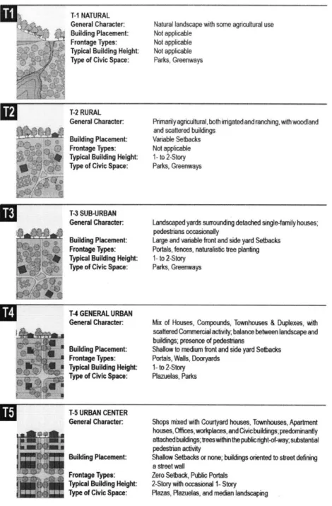
The Transect is traditionally divided into six different zones which include: Rural Preserve, Rural Reserve, Sub-Urban, General Urban, Urban Center, and Urban Core.
The application of the Transect is fairly simple and straightforward in that rural elements
should be located in rural locations, and urban elements should be located in urban
19 Henderson Interview, 2008
20
locations. The Transect can also be calibrated, depending on the community, to have one of the transect zones be larger than the others to emphasize the community's dominant urban or rural character. One of the most significant implications of the Transect is that it is a way to code for good urban principles in a range of human habitats21. Duany's
intention for creating the Transect was that it would create pedestrian-oriented, diverse, and public human environments.
SmartCode is different from conventional zoning in that in conventional land regulation, plans are kept separate from codes. The SmartCode integrates procedures for the
preparation of plans directly into the code and uses these procedures as the main organizing structure of the code. These are not plans in the sense of long-range,
comprehensive plans, which are often vaguely defined and difficult to translate into code. The plans that make up SmartCode are specific guiding principles of good urban form used to provide a framework for the Transect Zones22.
There are three types of plans described in the code based on land-use types. The first type is the sector plan, which operates on the regional scale and focuses on achieving an ecologically sound framework composed of environmentally protected resources. The second is the community plan, which demonstrates its ability to implement more than one development type dependent on Greenfield or infill development type. The third type is the Site Plan, which operates on the smallest geographic scale and prescribes lot and building requirements that vary for each type of the Transect Zone23.
21 Duany and Talen, 2002 22 Henderson Interview, 2008
One of the most important procedural aspects of the SmartCode is that the code is not
integrated with existing zoning regulations. The SmartCode will make reference to "existing code" as a separate set of regulations, and this ensures its integrity24. The
SmartCode is also specific about which entities are responsible for preparing the Plans
-the Sector Plans and Infill Community Plans are prepared by -the local planning office, whereas Greenfield Community Plans and Site Plans are usually prepared by a private
developer or property owner. Finally, the Code lists incentives that can be used by the local government planning office to encourage use of the plan. These can include allowing an application to be processed administratively rather than through public
hearing; giving priority to an application filed under the SmartCode regardless of the
existing permit queue, waiving review fees, allowing increased density through
subsidized development rights transfer, waiting traffic impact reports; and providing tax
relief for first-time buyers of dwellings in certain zones2 5.
The Smart Code is significantly different than a conventional zoning code. The idea
behind the SmartCode is that it will produce an urbanism that is fundamentally unlike
conventional sprawl, producing urban areas that are compact, pedestrian-oriented, and
containing mixed-uses. People will want to live in such communities, thereby reducing
pressure to consume natural habitats and convert more land to low-density sprawl. Both
the case study of Leander, Texas and Taos, New Mexico are based on the SmartCode
model and will be described in further detail later in this thesis.
24 Henderson Interview, 2008 25 Duany and Talen, 2002
3.3 Current Form-Based Codes
In more recent years, form-based coding has become a formalized, regulatory planning tool. Chicago consultant Carol Wyant created the term form-based code in 2001. Until this time, SmartCodes and codes based on the transect principle were called a variety of names including "traditional neighborhood development (TND)" and "form codes.26'
Today there are a number of consultants that practice form-based coding, each using their own model based off of the transect theory. Since 2001, form-based codes have
gradually changed the nature of zoning with their new approach to development
regulation. Form-based code expert, Paul Crawford has identified that form-based codes differ from conventional zoning codes, "in terms of the process by which they are
prepared, the substance of the standards they contain, the mechanisms by which they are implemented, and the built form they produce."
3.4 The Coding Process - Charette
Form-based coding is gaining recognition and becoming more desirable in part because it relies more heavily on community input than most planning processes. Form-based codes follow a conventional planning process that includes vision-based community participation up front. In addition to the initial visioning process, the community is also charged with drafting and administering the form-based code to enforce their vision. Because the community is holistically involved throughout the process, they are
constantly engaged in discussion about urban form, design, look, and feel. The planning process mimics a typical "desired future" exercises most often used for general plans, but has evolved into a community charette, which is an intensive weeklong process where members of a consulting team, city or town administrators, and as many citizens as
possible can be engaged. Sometimes there are variations on that theme, which may mean a series of community meetings or "discovery workshops" in which specific groups of people are selected to participate in the charette process27.Typically in these cases,
citizens are still welcome to participate at any time, and there are community check-ins at the end of each day for community members to make certain their visions are being realized. According to all of my interviewees, the charette process is transparent and
inclusive, giving a community ownership of the plan, helping to "debug" it in the
process. This prevents issues from arising about inclusiveness and "visions not realized"
when the code goes to formal hearings for adoption.
One attractive attribute of the charette is that it is more intense and efficient, bringing
together consultants for one week to work out as much detail as possible and essentially write the draft plan by the end of that week. Teams include architects, engineers, planners, economists and illustrators. Starting with the community visions, the team of
consultants works with the illustrator to create drawn and computer generated images that
most accurately and realistically represent what is possible, based on the feedback the
team received28. One common criticism of New Urbanism and form-based code charettes is that they are graphics-heavy, presenting illustrations of idealistic
improvements to communities that are not achievable based on current market conditions
or legal restrictions, for example29. I consulted with Paul Crawford to learn whether or
not this was true, and was assured that, "anytime an illustrator is creating a new scenario
for a community, there is a team of experts looking over that artists' shoulder ensuring
27 Crawford Interview, 2008 28 Crawford Interview, 2008
that everything drawn is feasible." The charette process is able to achieve quality results in a short-time frame because of the expertise and synergies between a diverse group of professionals that are able to ensure that the new code is achievable.
Peter Katz, President of the Form-Based Codes Institute, describes the following experience when working with communities during the charette process on form-based codes: "During the first few days of a charrette, citizens are shown startling new visions of their community that bear little resemblance to what is there now. On first viewing, they're often taken aback. But as citizens begin to consider new possibilities, they start to wonder whether they really could have that beautiful public square or the new branch library like the one shown in the design team's renderings. And while such musings are interspersed with fears of increased density and related impacts, community members frequently come to support, and feel a sense of ownership of, ambitious growth proposals that include the features they most want in their neighborhood. Once accepted, however, citizens again become skeptical as to whether the stunning imagines they're seeing could ever be realized. After all, most have seen renderings of grand plans that never got off the ground. In cases where something did get built, the final results may not have
measured up to expectations generated by the initial renderings.30"
Form-based codes do mitigate these fears because, as mentioned before, they work best when they are developed as a draft during the charette process. Doing this allows for the proposed ordinances to be presented alongside the drawings thus giving more confidence to the process and coding document. Equally important, is that the laws are written while the enthusiasm of the charette process is still fresh. Often times with community process 30
and traditional zoning ordinances, visions get watered down because of the time lapse between when visioning occurs and when visions are synthesized to become regulations.
3.5 Organizing Principles: Transect, Building-Type, Street, and Frontage
The organizing principle of the form-based code is the transect. There are a variety of
consultants following the Form-Based Codes Institute criteria, all of which using the
transect as the primary organizing principle. As previously explained, the transect was
developed by DPZ as a development model to organize the human habitat in a natural
continuum of intensity from most urban to most rural. One of the benefits of the transect
is that it applies to most, if not all, of the elements of creating a great place, from building
form and placement to parking, use, public spaces, signage, and lighting. Whether
through the SmartCode model or any other transect-based model, the transect must be
calibrated to local conditions and intentions of each community. This means creating
separate zones for each unique area in the community based on urban design intention, intensity and uses. The transect model, however, is not one-size-fits all. Often times, the
zones will be renamed for the greatest legibility per community. As I will explore in my
case study on Taos, New Mexico, it is sometimes necessary for a community to create a
new sub-transect zone to best accommodate their community's goals for both
development and preservation.
The transect is the most commonly used organizing principle for form-based codes, but
there are other methods that are occasionally used under special circumstances.
Building-Type Based Codes use building types as their organizing principle. This is
common among earlier codes used within private development projects. Currently, this
reinforce the character of a community. Street-Based Codes are another earlier coding method that looked at streets as the organizing principle. Specifically, they looked at the design and location of streets and secondarily how the buildings interact with the streets. Finally, Frontage-Based Codes used frontages as their organizing principle and focused their regulations primarily on the way that buildings address the public realm, typically the street. Again, this approach influences the character of the public realm but is less common than the transect.
3.6 Form-Based Coding Standards
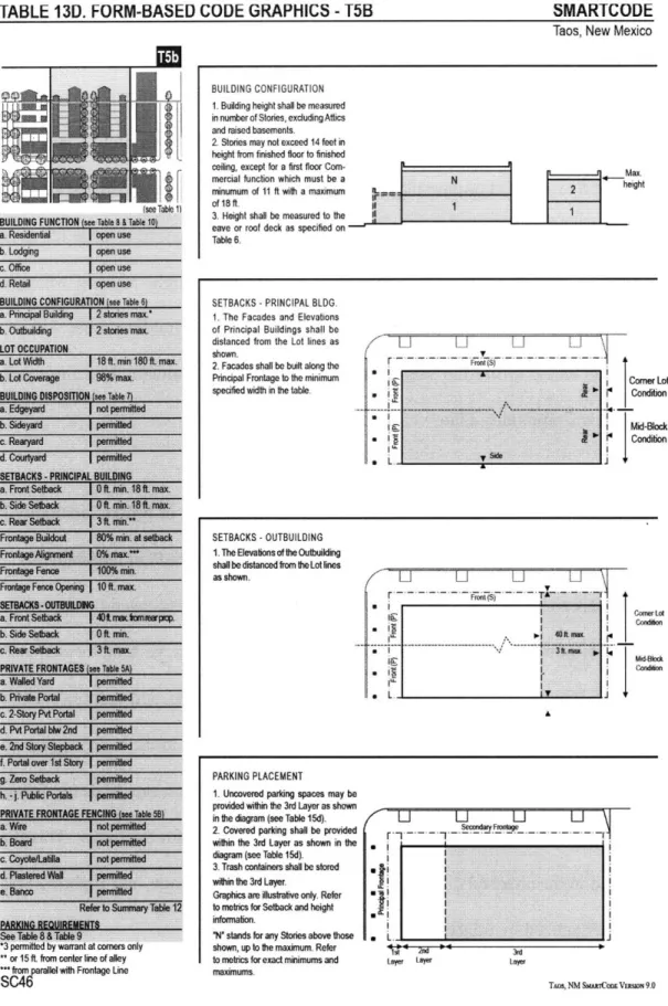
The formalization of form-based codes was simultaneous with the formation of the Form-Based Codes Institute. One of the primary goals of the FBCI was to establish a list of both mandatory and optional components for a form-based code. The following are a set of mandatory components as outlined by the FBCI:
A Regulating Plan: Every FBC must have a regulating plan, which is a plan or map assigning the code's various standards to physical location. This is similar to a zoning map, in which the boundaries refer to the coding document to determine more specific rules for design. This plan will often also include development requirements such as street frontages, ground-floor retail use, or building types required. Typically, the regulating plan applies the zones within a framework of streets and blocks to help create a transition between zones and to ensure the individual character of the "public realm".
Public Space Standards: Public Space Standards are crucial for affecting the quality and character of the parks, plazas, open spaces, and public thoroughfares. The qualities of
these public spaces are instrumental in creating community character. Thoroughfares
make up a large percentage of overall public space and their design is a critical
consideration. They are considered the "backbone" of a neighborhood providing
pedestrian and vehicular access while simultaneously becoming a community's primary
public spaces. Thoroughfare regulations include design specifications for sidewalks, travel lanes, street trees, street furniture, and the interface with the buildings.
Thoroughfares should be calibrated by transect level, coordinating appropriate street
types and features with the rural or urban nature of each zone.
Civic spaces are equally important to thoroughfares within public space standards. Civic
spaces, such as parks and plazas, are democratic spaces that allow for public gathering
and when well designed can add to the vibrancy and civic health of a city. In regards to
civic spaces, public space standards regulate parameters such as minimum and maximum
sizes, types of spaces and their appropriate locations, their functional role within the
community, and landscaping. Similar to thoroughfares, civic spaces should also be
calibrated for each transect zone. For example, a hardscaped plaza would be
inappropriate in a more rural transect zone, but would fit nicely within a more urban core
setting.
Building Form Standards: Building Standards most significantly represent the visual
form and character created by a form-based code. These standards establish specific
physical and use parameters for each transect zone, in addition to parameters that apply to
all zones. Building Form regulations control the configuration, features, and functions of
lot sizes, building placement and form, use, parking, encroachments, and frontage types, and may also include other regulations, such as for building types or architecture. The creation of building form standards may seen relatively simple and straightforward, but require careful orchestration between buildings, public spaces, and private spaces. According to Paul Crawford, "To create Building Form Standards, the FBC consulting team works with the illustrative plan and visioning documents, critically analyzing and regulating the three-dimensional characteristics of existing and proposed buildings and areas. As the Building Form Standards evolve, the team tests the regulations on existing lots."
The creation and location of parking is often the most contentious issue in any planning process, which makes it no exception within form-based coding. As seen in post civil war urban development, parking can leave scars in the middle of the urban fabric. However, parking is necessary and good design can mitigate many of the negative
impacts it has the potential of creating. Parking requirements should be calibrated to the transect, with fewer to no required spaces in more urban places where alternative transit options exist and a significant portion of the population walk to retail and commercial uses. Back Bay in Boston is a good example of an urban neighborhood in which a form-based code would call for no required parking spaces since transit access and walkable proximity to amenities exist.
One of the problems with parking structures and garages is that they can be unsightly and disrupt the character of a downtown. Additionally, they're ingress and egress can create hazards for pedestrians, especially on a busy downtown street. New innovations in
parking structure design have the ability to hide parking structures by, for example, wrapping the first floor in retail or office space uses. To increase retail security, garage
and structure entrances can be located on side streets rather than on the main commercial
streets.
A misconception of form-based codes is that they regulate form first and land use second, thus allowing for a "free market" economy. This is false. Form-based codes regulate
land use, but in a different manner to a different degree than conventional zoning. Like
conventional zoning, land use can be regulated through the number and type of land uses
in the zones provided by the code, by limiting certain land-use types to certain zones, and
by identifying the land uses allowed within each zone as "permitted" or "conditional".
Communities do not always have faith in the local economy and thus choose to control
the location and type of land uses in their codes. Also, there are obviously land uses that
have hazardous characteristics and do not belong next to housing, for example. Unlike
conventional zoning, allowed uses are identified based on what a community says they
want and do not want within each zone. Since form-based codes are responding to the
sprawling development patterns created by segregating uses through zoning, it seems
counterintuitive that form-based codes would produce different results given its land use
regulations. Form-based codes are different than conventional zoning in that they
provide more flexibility for the number and types of land uses allowed in zones by
creating more generic land-use categories. Although these categories are more generic, more specific uses within these categories are often subject to zoning review for
Code Administration: This includes the requirements for the project application and review process, which is different for every community.
Glossary: A glossary of definitions of uncommon technical terms and phrases used in the code, as well as definitions of the land use types used in the code.
The following are optional components of a form-based code:
Block Standards: Walkable communities require small blocks within an interconnected network of streets. Optional regulations to create block standards will further improve the character of a community by ensuring its walkability. Streets, alleys, lots, and build types
create this network of streets, creating the block and must all be woven together when formulating regulations.
Building Type Standards: Another preconceived notion about form-based coding is that they dictate the architectural styles and building types of a community. While this is certainly the case in some instances, building type standards are not required for form-based codes. In the earliest form-form-based codes, building types played a more prominent role (Seaside, for example) because they were typically used for private projects
undertaken by a private developer on a large piece of land as a greenfield development. Since Seaside and other early examples, form-based coding has shifted from strictly greenfield development to primarily infill-based projects. Infill-based projects bring with them more regulatory demand, and thus building type standards in many instances became too complicated to mandate. Additionally, many criticisms came out of the early form-based code examples, one of which being the lack of diversity within the building stock required to create vibrant and unique communities. Today, FBC practitioners are
putting more emphasis on building type standards in order to create better-designed
developments. Providing entitlements to developers based on building types as opposed
to FAR and density is doing this"3 . It is a challenge in some places to bring mixed-use
building types into a neighborhood and a development market that is comfortable with
single-family homebuilding. However, providing a diverse mix of housing types within a
community has multiple benefits, which allow people to transition over time into
different housing types while remaining in the same community, and creates a more vibrant public realm. Examples of building types are townhouses, detached single-unit
houses, courtyard apartments, and live/work units.
Architectural Standards: Some communities choose to use architectural standards within
their form-based coding documents. It is important to remember that the primary
objective of the form-based code is to create a specific urban form, and adding
architectural style requirements to the code is both optional and not appropriate for every
community. However, when used within the proper context, architectural standards can
lead to higher-quality development under the code. There are four levels of architectural
regulation that can be incorporated into a coding document: complete regulation,
including details; quality and local character regulation; basic regulation for basic quality;
and no architectural standards. Comprehensive architectural standards can include
massing, fagade composition, windows and doors, elements and detail, and palette and
combinations of materials.
31 Under conventional zoning, regulating through FAR encourages a developer to max out buildable space
According to Paul Crawford, the consultant would not typically recommend regulating architectural style. The purpose of regulating architectural style is in hopes that the style will be represented authentically. With architectural requirements, there is a chance that faux styles will emerge resembling traditional architectural styles but of lesser quality and design. Additionally, requiring architectural style can alienate the architecture
community by unnecessarily getting in their faces and ultimately discouraging development. The building envelope is intended to create a better public realm and therefore, more freedom with architectural styles will most likely create more and more authentic results.
Green Building Standards: Increasingly, the building world is becoming more aware of environmental issues and green development has become a trend in architecture and planning. Green Building Standards include specifications for environmentally sensitive, energy efficient, and low carbon footprint buildings that assist in achieving community
sustainability goals.
Landscape Standards: Landscape standards are regulations for the character and quality of the landscape within private spaces, but as it affects the public good, such as requiring native species to address water usage.
3.7 The Form-Based Codes Institute
The Form-Based Codes Institute (FBCI) was established in early 2004 by Peter Katz and
15 other New Urbanist architects, planners, and attorneys at a meeting convened at the
Driehaus Estate in Lake Geneva, Wisconson32. These practitioners met to consider
various aspects of this emerging regulatory technique and all collectively serve as the
FBCI board of directors. The intent of creating the FBCI was to define form-based
coding, to establish best practice standards, and to advance the practice of the Form-Based Codes as a means of providing a regulatory framework for sustainable
development.
The FBCI has received continual financial support from the Richard H. Dreihaus
Foundation. This funding and support has allowed for the Institute to give out an award each year (there have been two rounds thus far) to a community that has exhibited exceptional achievement in the writing and implementation of form-based codes. In
addition to this award that is presented at the Congress for New Urbanism's national
conference, the Institute has created one place for all form-based code practitioners to
convene over emerging ideas and the direction of this regulatory tool. The FBCI website
provides resources and links to form-based code articles and good examples of case
studies. There are also continuing education courses that are offered by the Institute to
further normalize the practice of form-based coding and to provide new communities
with the resources they need to bring a form-based codes to their community.
Practitioners that are on the FBCI board volunteer their time to give lectures and teach
courses at universities, further propelling the discipline into common planning practice.
One of the criticisms and trepidations about form-based coding is that there has evolved a
mass appeal around the discipline in a very short time, partly due to the formalization of
the Institute. Paul Crawford shared in an interview that he is worried that the FBCI may
codes has been one in which the staff recommendations made on individual projects to decision-making bodies were not always followed - and sometimes the recommendations were fragrantly dismissed for illogical reasons. Since form-based codes are not
completely prescriptive, it can be challenging in a regulatory environment where most
often, elected and appointed officials are involved with development decisions. In particular, core property rights-oriented communities have been most skeptical of how form-based codes translate into an existing regulatory framework. The issue is
transferring control from these decision-making bodies as well as changing the process for development to an unfamiliar and new process.
One suggestion Crawford has brought to the attention of the FBCI is to undertake the continuing review of adopted form-based codes to see if they are turning out
development that they promised33. If they are not, why not and what can be done to
improve the existing tools? And furthermore, this will involve the exploration of whether the problem is with the tools, process or local politics. Exploring the ongoing outcomes of form-based codes is essential in understanding their impact, how to make them better, and how to offer possible solutions to problems.
33 In regards to the outcomes of form-based codes, Crawford believes it is too early to tell if they are tnruly successful or not. At professional development courses and with communities, Crawford and other consultants do a section called "reality check", bringing to the attention of attendees that physical change within a community can only occur in two ways: (1) Through private development, and (2) Through the municipality making changes in public property, such as streetscape renovation.
CHAPTER 4: CASE STUDY OF VENTURA, CALIFORNIA
Buenaventura, California is quintessentially Southern California with palm trees, beach views, and breezy retail spots lining the main downtown strip. Ventura, as it is better known is located north of Los Angeles along State Highway 101 and 30 miles south of
Santa Barbara along the Pacific Coast. Ventura is best known for its surfing spots, historic mission, museums, galleries, dining, and shopping. Most of the goings-on are
located in downtown Ventura where activity is focused around California and Main
Streets located just below the ornate City Hall building which stands as a symbol in the
heart of the downtown.
4.1 History
The history of Ventura began with the Mission San Buenaventura, which was the most
successful and influential of the California Missions founded by Father Junipero Serra.
The mission lands were divided up by the Spanish settlers and transferred to private
property owners in 1813 following the great earthquake of 1812-1813. In 1841, the
Rancho San Miguel was deeded to Raimundo Olivas, who built a magnificent hacienda
south of Monterey on the banks of the Santa Clara River called Olivas Adobe, which still
exists today. In addition to the Old Mission that still exists as a historical landmark, the
Olivas Adobe is part of Ventura's historic past and has been restored and refurnished as
an early example of California settlers. After the Civil War, more American and
European settlers migrated to California, buying land from the Mexicans and squatting on
property. In later history, easterners, including the railroad magnate Thomas Scott, acquired land holdings. Scott was impressed by one of the young employees, Thomas
manage Scott's property in Ventura. Bard is often regarded as the Father of Ventura and his descendants have been prominently identified with the growth of Ventura County. The Union Oil Company was organized with Bard as President in 1890 with the main oil
field drilled in 1914. At its peak it produced around 90,000 barrels of oil per day34.
Throughout its history, Ventura has simultaneously considered itself a leisurely and laid back Southern California City, while remaining prosperous and economically strong. The City owes much of its profits to the surrounding valleys and rivers, which contain rich soil responsible for some of the best citrus crops in California. The growers along the Ventura and Santa Clara Rivers together formed Sunkist, the world's largest
organization of citrus production35
One of the reasons Ventura was able to maintain slow and steady growth was due to the lack of major thoroughfares through the City. Until 1969 when the Ventura freeway between Los Angeles and Ventura was completed, travel by auto was slow and hazardous. For most of the century, which followed the incorporation of Ventura in
1866, it was relatively isolated from the southern part of the State. From the north, entrance was equally challenging with access consisting of a single road along the beach. In the early history of Ventura, stagecoach passengers had to wait until low tide for the horses to cross the beach. From the inland, Ventura abuts the Los Padres National Forest with topography that was not crossed until the creation of the Maricopa Highway built in the 1920's36.
34 Ventura County Museum of History website (www.venturamuseum.org)
35 Ventura County Museum of History website (www.venturamuseum.org) 36
Ventura has seen steady growth since the 4,156 people that inhabited this sleepy
community in 1920. In 1930 the population grew to 11,603 and by 1950 the population
reached 16,643. Today's population is around 106,000 and continues to grow with an
influx of Los Angeles residents in search of more affordable homes and a more laid back
southern California lifestyle37.
4.2 Getting to the Code
"Over the next ten years, Ventura will emphasize our history, culture and unique
character to sustain the downtown as our city's authentic heart - the pre-eminent area
for civic and artistic life and a preferred location for retail and office commerce"
- City of Ventura Vision Statement
The City of Ventura's General Plan, mandated by California state law, was adopted in
2005. The plan was thoughtfully constructed, giving special attention to Smart Growth and New Urbanist principles. However, in order for the new plan to be implementable, the existing zoning code required revision to better align with the new principles and
city-wide vision set out in the new plan. According to Ventura Community Development
Director, Kaizer Rangwala, the City examined various formats for a new zoning code and
concluded that form-based coding would fit well with the City's goals for development.
Additionally, City Manager Rick Cole came to Ventura from the position of City
Manager of Azusa, California. Azusa adopted a form-based/hybrid code under Cole's
direction and thus Cole was able to confidently bring a group of important stakeholders
together to learn about the benefits of form-based codes and eventually garner sufficient
support to implement one.
Initially, Ventura was interested in adopting a citywide code and began by developing the framework for this code, trying to work with the existing general plan to understand the best way to go about incorporating new zoning into the general plan. With a turn of events, the citywide project was put aside as city staff and resources were pulled into more pressing projects. Although the framework was unfinished, enough had been
completed to get a sense of where the City wanted to focus efforts geographically and general guiding principles for future development. One example of more pressing developments around the City were greenfield sites in Ventura where developers were proposing strip retail and big box developments that were allowable under the current zoning. These sites were higher priority than single-family residential neighborhoods, for example, because they were less stable and required guidance to ensure positive growth. Form-based codes remained a focus of City efforts, but were more strategically focused
in order to guide growth in the areas of greatest concern38.
One such area that became a focus for a form-based code was Ventura's downtown. A Downtown Specific Plan to guide growth was first created in 1993 and subsequently updated in 2003 and most recently in 200739. The challenge of the downtown has been a positive one since Ventura already has a vibrant downtown with a strong commercial market. Form-based coding was brought into the downtown to better shape the growth that had been occurring at a fast pace. The major objective of the City was to get the coding work done and adopted quickly so that there were clear regulations and standards required of developers about what should exist in the downtown, eliciting clear rather than compromised results. Like most places, California is a complicated place to plan 38 Rangwala Interview, 2008
39