WHAT IS AN URBAN STRUCTURE?
THE CHALLENGE OF FORESEEING 21ST CENTURY SPATIAL
PATTERNS OF THE URBAN ECONOMY
Richard Shearmur
Inédit / Working paper, no 2011-06
WHAT IS AN URBAN STRUCTURE?
THE CHALLENGE OF FORESEEING 21ST CENTURY SPATIAL PATTERNS
OF THE URBAN ECONOMY
Richard Shearmur
paper prepared for :
Seminario Internacional Ciudades, Globalización y Desarrollo, El Colegio Mexiquense, A. C., Toluca, Mexico
Wednesday 21st and Tuesday 22nd September 2011
Institut national de la recherche scientifique Centre - Urbanisation Culture Société
Montreal
Richard Shearmur
Centre - Urbanisation Culture Société Institut national de la recherche scientifique 385, Sherbrooke Street East
Montreal (Quebec) H2X 1E3 Phone: (514) 499-4000 Fax: (514) 499-4065
www.ucs.inrs.ca
This document can be downloaded without cost at:
www.ucs.inrs.ca/sites/default/files/centre_ucs/pdf/Inedit06-11.pdf
Abstract
Urban geographers (and urban economic geographers in particular) have, at least since the early twentieth century, examined the way in which cities spread out across space, occupy it and transform it: the resulting patterns and regularities are often called „urban structure‟, and numerous questions derive from this concept – such as whether or not all cities share an underlying common structure, whether the same or similar processes modify these structures, and the influence of context (be it cultural, political or geographic) on the material outcome of these processes. Furthermore the idea of urban structure itself is problematic, since any given city is structured in multiple ways along multiple dimensions, as postmodern thinkers have emphasised. This paper sets out to discuss what is meant by urban structure – focussing more particularly on cities‟ economies -, to broadly summarise some of the general patterns and processes that govern the geography of economic activity within cities, and to tentatively propose a framework for conducting relevant empirical research and for thinking about how urban economic patterns will evolve over the coming years.
Key Words:
Urban structure; urban theory; empirical analysis; metropolitan; processes; urban economy
Résumé
Les géographes urbain (et en particulier ceux qui s‟intéressent à l‟économie urbaine) ont, depuis au moins le début du vingtième siècle, exploré la manière dont les villes s‟étendent dans l‟espace, l‟occupent et le transforment : les patrons, formes et régularités qui en résultent sont souvent appelés « structure urbaine », et de nombreuses questions émanent de ce concept. Les villes partagent-elles une structure sous-jacente commune? Est-ce que des processus similaires modifient ces structures dans chaque ville? Quelle est l‟influence du contexte (qu‟il soit social, politique ou géographique) sur le résultat matériel de ces processus? En plus de ces questionnements, l‟idée même d‟une structure urbaine pose problème car chaque ville est structurée de multiples façons selon de multiples dimensions, comme le soulignent les penseurs postmodernes. Ce texte à pour objectif de proposer une réflexion sur ce que l‟on entend par « structure urbaine » – avec une attention plus particulière sur la structure économique des villes –, de résumer certains des processus et régularités spatiales qui régissent la géographie des activités économiques urbaines, et d‟esquisser un cadre pour effectuer des études empiriques pertinentes et pour réfléchir aux évolutions des formes que pourraient prendre la géographie de ces activités économiques dans les années à venir.
Mots clés :
INTRODUCTION
There is a vast body of work, stretching back at least to the Chicago school sociologists of the early 1900s (Park et al, 1925), that analyses, describes or uses the concept of urban structure. Prior to this city planners since antiquity had designed cities (or managed cities that had grown organically, Kostof, 1989) – and had therefore studied and thought about what we now call urban structure even though the term is of more recent coinage.
Yet despite the ubiquity of the concept (a brief search for the term „urban structure‟ in Google scholar reveals over 28 000 hits1), or maybe because of it, it is difficult to pinpoint what is actually meant by the term. For example, urban structure can refer to the sociological structures of urban communities (Axelrod, 1956), to the spatial configuration of land uses at the metropolitan scale (Harris & Ullman, 1945), to the relative location of residences and workplaces (Giuliano, 1993), to the spatial distribution of economic activity in cities (Anas et al, 1998), to the geography of population densities (Wang and Zhou, 1999) and so on. A city can be structured along many lines – social, economic, political, cultural, imaginary – and the structures themselves can have multiple dimensions – spatial, organizational, administrative, racial (Dear & Flusty, 2002).
Given the multiplicity of structures and structural dimensions, it should be made clear from the start that this paper is written from the perspective of an empirical student of the geography of urban economic activity. In other words, even if questions relating to urban structures in a general sense will be touched upon, it is the spatial structuring of the urban economy that will serve as a backdrop to the discussion. The empirical perspective from which the paper is written is also important: although I touch upon questions of theory I do so from the perspective of a researcher who has had some difficulty reconciling the work of urban theorists with detailed empirical research and observations. The paper describes some of these problems and proposes a framework for understanding how wider social theories can feed into detailed empirical work. Indeed, an underlying motive for this paper is that unless empirical researchers reflect upon the way in which wider theories impact their work, there is some danger that the divide that exists between urban theorists on the one hand and empirical researchers on the other (alluded to, for instance, by Beauregard, 2006) will either remain largely unbridged, or will tend only to be crossed in one direction, by theorists who examine and challenge empirical work.
A final question that motivates this paper is the way in which urban structures change over time, and whether or not this can be foreseen. However, a preliminary task necessary for any discussion of evolving urban structures is to clarify terms and concepts and to suggest a framework within which this evolution can be discussed. The first section of this paper therefore
1
discusses what is meant by urban structure. The purpose of this is not to provide an extensive review of all that has been written on the subject, nor to propose a unique definition, but rather to highlight some ways in which the term has been used and to explore a few theoretical questions that are raised by the concept.
The second section will narrow the field considerably and focus upon a specific example of urban structure – the spatial distribution of economic activity. Here a broad overview will be given of the various key patterns and processes that have been used to describe and organise this area of study, and a framework for thinking about urban structures (at least those that pertain to the economy) will be proposed. Whilst partly abstracting from the questions raised in the first section, the idea that urban structure is inherently complex – i.e. is the outcome of a complex system operating at various scales and with varying degrees of predictability (Costanza et al, 1993; Benenson, 1998; Manson, 2001; Shearmur et al, 2007) - will nevertheless carry through in this section and be fleshed out.
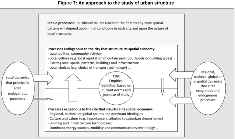
The third section builds upon the first two, and attempts to grasp how one may apprehend changes to urban structure over the coming years. Apprehending change – and in particular making predictions – is fraught with difficulty for at least two reasons. First, from within the field, tackling complexity in a meaningful way is a daunting task. This is not so much a methodological problem as a conceptual one, and some ways of doing so will be discussed. Second, from outside the field, the world is changing: cities are not closed systems and changes in the wider world influence different cities in different ways. In particular, after a period of relative stability with regards the technologies and transport systems that govern the way in which people and goods relate to geographic space, it is apparent that fundamental changes are underway (Rubin, 2009). This will modify the nature of the processes that structure cities, though the existing built environment and flows can only change far more slowly. Thus the „shape‟ of cities in the future cannot easily be foreseen, though the imprint of current structures, themselves shaped by each city‟s history, will undoubtedly continue.
WHAT IS URBAN STRUCTURE?
In this section three approaches to answering the question of „What is an urban structure?‟ will be proposed. These do not pretend to exhaust the possibilities, but rather to illustrate some of the difficulties inherent in any reply.
A common-sense approach
One possible reaction to the question asked in the section‟s title is that we all know what an urban structure is and that the question is therefore of little interest – this reflects what I call a „common-sense‟ approach2
. It is an eminently reasonable one: the term is often used, and empirical studies frequently explore it. Thus, reference to the relevant literature should answer the question. The common-sense approach cannot be lightly dismissed: most of our daily interactions and communications – and most empirical research on urban structures (my own included) - are able to occur precisely because we share common-sense notions that are not questioned each time they are referred to. In academia, communities of researchers share bodies of accepted knowledge that enable them to engage in important, policy relevant research, and that often lead to changes in the body of ideas as new empirical evidence challenges received wisdom.
Amongst different communities of researchers there indeed exist pragmatic understandings of what urban structure is. Amongst urban economic geographers, for instance, the study of urban structure implies understanding how different types of economic activity locate across urban space (Anas, et al, 1998). This in turn implies calling upon a series of preconceived and frequently unexamined ways of categorizing the (economic) world under study: a typology of economic activity is usually assumed, frequently premised upon standard industrial classifications. Units of analysis are chosen, most frequently jobs (at the place of work) or establishments. Location is then explored in as much detail as possible, but is then usually classified according to a canon of pre-established patterns which have evolved as both theory and empirical observation have developed. For instance, economic activity is either „polarised‟, „linear‟, „concentrated‟ or „dispersed‟, and each activity is either co-located with, or separated from, other types of activities. These patterns and relationships, often introduced as being self-evident objects of enquiry, in fact reflect preconceived notions and processes (theories). The end result of this type of analysis is a description of each city along a few structural dimensions – i.e. a city‟s (economic) urban structure. Urban social geographers follow a similar approach, social or ethnic classifications being used instead of economic typologies, and the canon of possible patterns and interrelations being slightly different (e.g. Wong & Shaw, 2011; Hanlon, 2010). Such an essentially descriptive approach either rests upon a theoretical understanding of the processes which lead to the observed patterns, or serves, in an inductive fashion, to identify and further our understanding of these processes. In either case the approach is strongly empirical, and the idea of urban structure is rarely problematised. The observed structure – i.e. the current material pattern that constrains the future development of a city – is the outcome of (theorized)
processes of agglomeration, segregation, profit maximising, political actions, planning decisions, class conflict or rent seeking. These processes intertwine and interact in such complex ways that they are often studied in isolation, and almost always in disciplinary silos: economists, for instance, will only take social urban structures into account in a peripheral way, sociologists will only superficially consider transport networks, and political scientists may only parenthetically include spatial economic structures in their analyses.
The common-sense approach, as described above, is useful. It enables empirical and applied research to be conducted, and, as the limits of existing paradigms and theories are reached it also enables new ones to be developed, thus furthering knowledge in a way that is more fundamental than may at first appear. The approach, is, however, limited: in particular it elides the central question concerning the nature of an urban structure. The concept of „urban‟ is implied, and the concept of „structure‟ may best be summarised as a (geographic3
) pattern that is the outcome of one (or many) processes, and that conditions future changes in some way. The question of definitions will be turned to in the next sub-section.
Given that each community of researchers examines the structures of different sets of actors and elements in a city, and refers back to different fundamental processes, the use of urban structure in the singular seems unjustified: even from an empirical viewpoint there cannot be a single urban structure, but a multiplicity of structures – and this will be discussed in section 2.3.
A question of terminology
If the term „urban structure‟ is to mean something, then at the very least it should be clear what is meant by „urban‟ and what is meant by „structure‟. Although there is of course a common-sense definition of both terms, the problem lies in the fact that neither term is in fact as simple as it first appears.
A precise and unequivocal definition of „urban‟ is almost impossible. This impossibility lies in the fact that the word is not a technical term but one that draws upon the collective imaginary (Anderson, 2006; Soja, 1996). A city is not (only) an object, but a mental image that draws upon literature, films, advertising, daily observations, pre-existing theories and so on (Macek, 2006). Thus, whereas a statistical agency will provide a clear definition of the urban, based upon density (but at what scale?), upon contiguity between elements of the built environment (but why choose threshold x and not y?), or upon commuting flows (between which constituent geographic entities? what threshold? why commuting flows?), this definition does not exhaust the concept.
3
Henceforth I will no longer refer to research on non-spatial urban structures, such as political or social structures that are not specifically territorialised.
Quite the contrary: a statistical definition of a city is a pragmatic attempt to capture, using measurable data, the elusive concept, and may itself, in recursive fashion, contribute to structuring the concept itself (Shearmur, 2010).
Statistics are, of course, of vital importance to understanding the world, and the cities, in which we live: however, a problem arises when statistical definitions are reified and become confused with the concepts they are intended to (imperfectly) capture (Stewart, 2004). This is not an esoteric problem, but one that is almost inherent to the common-sense empirical approach described above. Virtually all empirical analysis that examines urban structures takes as a starting point a set of data – often a statistically defined urban agglomeration – which, it is posited, captures the „urban‟. Thus, at the outset the „urban‟ is taken to be a geographically limited portion of territory, usually delimited by low-density rural areas at its edges, and within which it is possible to study processes that have geographical outcomes (which are called structures).
On what basis and following which criteria should the spatial extent of the city be delimited? A city can be conceived of as a node where many interactions and processes overlap, but most of these activities stretch across space, often in discontinuous fashion following major transport, communication and cultural networks (Castells, 1996; Amin & Thrift, 2002; Bathelt et al, 2004). Thus, a city‟s spatial structure can be thought of as rippling out from a central area along various networks, terrestrial (road, rail etc.) and otherwise (electronic, cultural, economic...)4. Occurrences in one city may be strongly influenced by occurrences in other cities: if this is the case, each city‟s urban structure will be spatially discontinuous and intertwined with, and maybe part of, other cities‟.
Even if one were to simplify the discussion and consider a single city with its contiguous rural hinterland, the basis on which the city should be distinguished from hinterland is unclear. A straightforward classification based upon the extent of the built environment is somewhat arbitrary: do people living in exurban areas but working in the urbanised area constitute part of the city? Does economic activity located in lower density rural or semi-rural areas, but destined for markets in urbanised areas, form part of the city‟s spatial economic structure? And to what extent do parks and forests in the hinterland which provide leisure opportunities for urban dwellers participate in the urban structure – should they be considered part of the urban green network? In short, isolating a piece of space, calling it a city, and examining the internal processes that lead to its observed structure – a common enough approach and one I have used many times – hides numerous assumptions about what a city is and about the spatial extent of the processes at play.
4 Indeed, this central area itself may be conceived of as the overlapping – for a certain period – of trajectories and networks (Massey,
2005). However, the material imprint of these trajectories – buildings, roads etc. – mean that the city becomes something more than merely immaterial trajectories and networks.
The notion of „structure‟ is maybe even more difficult to encompass than that of the urban. Indeed, the mere fact of writing about structure implies structure (such as the abstract structure of language, the physical structure of its material support...). As Pullan (2000: 2) states:
„Without the singular notion of some structure or framework it is difficult to make sense of anything, but it is in the articulating of structure, resulting in a potentially infinite plurality of structures, that meaning resides‟.
As already noted when discussing the common-sense approach to urban structure, even from a pragmatic perspective there is no such thing as an urban structure, but a plurality of structures, each identified from a different disciplinary standpoint: each discipline – and to some extent each researcher – has developed his or her understanding of what a structure is.
It is not the purpose of this paper to provide a complete discussion of the idea of structure, or even of spatial structure. However, in the context of the study of urban areas, it is important to clarify the distinction between urban patterns (which are instantaneous photographs of the configuration of urban actors) and urban spatial structures (which are patterns that are either constant through time or that evolve under the influence of particular processes). It is most often patterns (of spatial distribution, of movement, of transport networks) that are studied: but the way they evolve over time, associated with an understanding of the processes driving this evolution, can provide an idea of underlying structure (and even of structures that go well beyond the spatial, but which the spatial patterns reflect). In this sense, the idea of urban structure cannot be dissociated from that of urban processes and time.
A spatial pattern is therefore not in itself a structure, but may reveal the presence of structures (McIntire and Fajardo, 2009). These structures (and the processes that underpin them) have a degree of continuity, otherwise they would not be structures. Hence structures imply some form of inertia: time is therefore a key dimension. Indeed, inertia – by definition - operates over time: an inertial structure at time t will constrain patterns at time t+1. This is especially true in an urban context where structures lead to patterns that are embedded in the built environment. Thus, even when the processes that explain an urban pattern at a time t have changed, the physical and material imprint of these processes remains: urban patterns themselves, once they have materialised, can become part of an urban structure by virtue of their physical and(or) legal5 permanence. Soja (1989: 248) writes of Los Angeles as a palimpsest, i.e. of a document upon which things have been written, erased, then re-written, but which keeps the trace of each layer of writing. By implication, whatever the processes currently shaping Los Angeles, past structures and processes retain some influence.
5
Whyte‟s (1988) study of New York‟s Plazas provides a good example of the distinction between pattern and structure in a spatial context. An instantaneous photograph of a crowded plaza will, of course, reveal a spatial pattern: people are located at particular points. However, the photograph will not reveal any structure. If an analyst claims to detect structure in the spatial pattern, it is because he or she is projecting a theory (of how people occupy space, of the processes governing social interaction in open urban spaces) onto the observed pattern. It is only after observing plazas for many years, taking time-lapsed photographs, observing the way in which individuals interact there, and confronting various theories with observations, that Whyte (1988) was able to write a book in which he proposes an account of the processes that lead to the spatial patterns observed. Given his intimate understanding of processes, Whyte is able to discern structure in patterns. An identical pattern without the understanding of processes is a random collection of people on a Plaza.
In short, the term „urban structure‟ is ambiguous, and no straightforward definition exists. Quite apart from the fact that cities are multi-dimensional, and each dimension is structured by different (though inter-related) processes, the very notions of „urban‟ and „structure‟ are by no means clear cut. Somewhat paradoxically given these complexities, the common-sense approach is not incompatible with questions regarding the nature of urban structure. It would not be possible to achieve any knowledge of cities, or indeed to test the limits of what is meant by urban structure, if concepts were never operationalised and explored. Operationalisation – i.e. devising observable or measurable approximations of a concept - enables empirical work to be performed, processes to be better understood, and enriches understanding of what a city, and of what an urban structure, is. It is only when the approximations necessary for empirical work are reified, when the type of ambiguity raised in this section is overlooked, that common-sense empirical work risks becoming „naively objectivist‟ (Sayer, 1992). Conversely, when these ambiguities become the sole focus of analysis and discussion, there is a risk of abstracting urban analysis from any concrete knowledge of the cities in which we live.
Is there such a thing as urban structure?
The questions raised by post-structuralists – of whom maybe the most prominent urban analyst is Michael Dear who has recorded the emergence of the Los Angeles „school‟ of urbanism (Dear, 1988; 2003; Dear & Flusty, 2002) and has proposed a non-structured approach to understanding the economic geography of urban areas (Dear & Flusty, 1998) – are directly linked to the discussion above6.
6
I will set aside the debates surrounding whether or not Los Angeles can be considered an exemplar of new trends (Gottdiener, 2002). As will become clear, LA is no more an exemplar than any other city, but research by LA scholars sheds light on a number of issues.
From the many diverse approaches that are inherent to a „polyvocal „approach to the city (Dear & Flusty, 2000), two elements will be discussed. First the contention that cities have no structure will be addressed. Second, and of maybe more practical importance, the idea that urban structures are not „urban‟ (in the sense that they are not necessarily governed by processes attached to a territory recognisable as a city) will also be raised (Soja, 1989, 1995; Dear & Flusty, 1998). The contention that cities have no structures can be countered by turning to clear evidence of structures, such as those that underpin the distribution across space of different income groups within cities (Shearmur & Charron, 2004). However, in the domain of urban studies, post-structuralists do not necessarily posit that no structure exists: rather, they emphasise that cities do not possess a structure. Indeed, a key contention of the Los Angeles school is that „a unified, consensual description of Los Angeles is ... unlikely, since it would necessitate excluding a plethora of valuable readings on the region.‟ (Dear, 2003). In other words, there are many people, disciplines and approaches studying Los Angeles – or indeed any other city – and there is no way, and no compelling reason, to determine which is the correct one (Ethington & Meeker, 2001).
If post-structuralism, in the context of urban studies, is understood as meaning that cities do not possess any single or unique structure, then it cannot be summarily dismissed by pointing to the existence of any particular structure. Empirical studies, whilst they reveal particular patterns or processes, do not disprove the existence of others that have not been sought. It is difficult to refute the idea that a city has multiple structures: even in the very focussed area concerned with processes that govern the intra-metropolitan location of high-order services, the processes that govern the location of new-build office space (Lang, 2003) are not necessarily the same as those that govern the location of management consultant employment (Shearmur & Alvergne, 2002), or the same as those that govern the location of head-offices (Jakobsen, 2005). Each way of looking at high-order services will reveal different (in this case connected) structures – but it is not straightforward to determine what the processes are that determine the location of high-order services, or what the ensuing urban structure (as it relates to high-order services) is.
If such questions arise when three studies looking at ostensibly the same object are confronted, it is easy to foresee that urban structures as they relate to population, politics, social classes, green space, waste generation, graffiti art and so on will rely on vastly different conceptual frameworks, understandings of what the processes are that shape each object of analysis, and indeed judgements as to what is worth studying and what isn‟t. In short post-structural urban analysts make explicit, and attempt to theorise, what is implicit in the great diversity of empirical studies of urban areas: that there exist a plurality of urban structures, and many ways of studying them, and that it is virtually impossible to gather them all and posit – after distilling their assumptions, epistemological positions and results – that such is the urban structure.
Such a position can leave empirical researchers uncomfortable since it is a short step from recognising this plurality of approaches to saying that anything goes. However, three rather down-to-earth principles can be of use in navigating post-structuralist doubt and in attempting to separate research on urban structures from everything else. The first principle concerns theory: even if empirical researchers do not always view themselves as theorists, it is important for them to recognise that theory – and by that I mean some ideas about how the world works and about how the elements being studied can be categorised and how they interact - is implicit in all analysis. This will be returned to in the paper‟s concluding section (section 4) where some suggestions are made about the different levels of argument that can be adopted by urban researchers.
The second principle relates to social relevance: even if there are a multiplicity of possible objects of analysis and approaches, there are far fewer that are of interest to policy-makers or local communities and about which decisions are currently being debated or which impact people‟s lives in important ways. Whether a critical or a facilitating stance is taken by the researcher, a focus upon questions that address current issues is one possible way of determining which processes, and which aspects of urban structure, are to be studied empirically. Furthermore, whatever the topic chosen, if it is irrelevant it will simply not gain much of an audience.
The final principle is one of methodology: in order for empirical research to be convincing, recognised methods of evidence gathering and analysis are necessary (Shearmur, 2008). Such methods tend to evolve slowly, are premised upon principles such as replicability and internal and external validity – in short on the basic principles that govern scientific research (Sayer, 1992). These are not, themselves, universally agreed upon, but neither have they proliferated: almost all research on urban structures will situate itself within a recognised methodological and epistemological approach – and will be rejected as research if it does not.
Beyond questions relating to the existence of structures, another fundamental issue raised in post-structuralist writing on urban areas relates to the question – also alluded to in prior sections – of the meaning (and extent) of „urban‟. This question will only rapidly be discussed here since it will be returned to below when discussing Dear & Flusty‟s (1998) Keno capitalism. However, a key point raised by writers such as Soja (1989, 1995) and Dear & Flusty (1998) – but also by others like Amin & Thrift (2002), Massey (2005), Robinson (2006), Brenner & Theodore (2002) etc. who are not connected with the LA School - relates to the urban nature of processes that structure urban areas. In different ways – Soja (1989, 1995), for example, by suggesting that the periphery organizes the centre, and Dear & Flusty (1998) by suggesting that global processes organise urban-scale behavior – these authors maintain that whatever the patterns and structures observed in urban areas they are not necessarily the consequence of urban processes.
Soja (1989) suggests that occurrences in Los Angeles are a consequence of wider forces such as the military complex, neo-liberal institutions (such as major corporations and their association with hegemonic power), and wide scale technological changes (for instance car usage) – all set within a radical postmodern perspective of how society functions (Soja, 1996: 3). Given that key actors and infrastructure are increasingly located in Los Angeles‟ periphery, he suggests that there has been a reversal of roles between the CBD and the suburbs. Maybe more importantly, he also argues that any attempt to understand Los Angeles‟ urban structure, any attempt to interpret observed spatial patterns, must call upon an understanding of processes that reach well beyond the urban and must theorise the way in which these processes reveal themselves – spatially – in particular locations. It is not, therefore, sufficient to take Los Angeles as an isolated city – a geographic space with an outer limit – and expect to understand its structures by considering the actions and motivations of local actors (be they economic agents, politicians, households or others). These actors are themselves involved in processes and are undergoing forces that extend well beyond the city.
Dear and Flusty (1998), make a similar general point when they maintain that there is no longer any identifiable spatial pattern to the location of activities – whether economic, leisure, housing or other – in cities. They suggest that activities now locate with an eye on global markets, global image and global accessibility. Thus, for example, it is no longer necessary for a major theme park to be accessible to the local population, because its market is regional or global. Similarly a major corporation may eschew a downtown location – one that is traditionally associated with high-order business activity – in favour of an office in a non-descript neighbourhood near an airport (or near a highway that leads to an airport) because its points of reference are no longer connected to the local but with global business activity.
Whereas the first challenge raised by post-structuralist urban theory does not completely undermine the idea of urban structure – but replaces it by a plurality of urban structures -, the second challenge questions the very existence of urban processes. Even if patterns are observed in cities, an important question revolves around whether, and in what sense, the structures and processes that are revealed are urban in nature.
These challenges – which are particular examples of wider challenges raised by post-modern thought and, more recently, by the cultural turn in geography – do not invalidate an empirical theory-driven approach to the study of urban structure. On the one hand, of course, these challenges serve to highlight that the „common-sense‟ approach adopted by many empirical researchers is not necessarily self-justifying, and they question accepted paradigms that often serve to interpret observations (Beauregard, 2006). On the other hand, however, the fact that empirical research on urban structures is socially relevant and that it often provides useable
information to governments, economic actors and activists7 can not in itself be lightly dismissed: even if this social relevance comes at a cost – fundamental questions are often elided – it is the very fact that many economic and social structures are taken as given that allows their consequences both good and bad (in terms of urban structure) to be explored and better understood.
ECONOMIC URBAN STRUCTURE: CBD, POLYCENTRICITY AND OTHER PATTERNS
Having raised a series of rather intractable questions in this paper‟s first section, I now propose to describe the understanding of urban structure that is common amongst students of economic activity. An attempt will be made to present this in a unified way: I will first suggest that there exist some fundamental processes that govern the location of economic activity in urban areas. I will then describe, in broad terms, the way in which the spatial patterns of economic activity – or at least our understanding of these patterns - has evolved in Western cities since the early twentieth century.
Some fundamental processes governing the location of economic activity in cities Although certain theories that purport to explain the location of economic activity in space rely upon very restrictive behavioural hypotheses (Alonso, 1964, for instance, builds a theory premised upon land rents, incomes, and accessibility to the Central Business District), these theories are usually developed to understand the consequences of particular assumptions, and do not purport to explain – except in a limited way – observed urban patterns. Such theoretical approaches do, however, have the merit of isolating some key processes that govern location choices. One could, of course, object – in the light of arguments raised above – that so many processes impact the location of economic activity that isolating a few key processes is doomed to failure. However, if failure or success is assessed by the capacity of the selected processes to describe certain observed patterns – at least in broad terms – then analysts of the location of urban economic activity have been able to identify some factors (of which those suggested by Alonso) that give spatial structure to the economy of cities.
In its widest sense, the type of process modelled by Alonso (1964) is one of accessibility mitigated by cost and preferences for different quantities of space. In other words, when choosing where to locate an economic agent will assess what he/she wishes to be close to (accessibility), what he/she can afford, and, given what can be afforded, what type of building or land is preferred (for example, for a given price a business can choose between a small suite of new
7 Empirical, and even quantitative, research has regained some legitimacy since it has become evident that it does not necessarily
involve any political stance. Indeed, empirical observation and quantitative measures have been critical in criticising the war in Iraq (Ellis, 2009) – though they are not sufficient to settle disagreement : opinion and belief fashion the interpretation of facts (Gaines et al, 2007).
grade „A‟ offices or a larger suite of old offices). Even though these basic principles are straightforward, the patterns that can emerge are almost infinite if one allows for different actors having different – and often multiple – accessibility requirements and willingness to pay. In an economic context it is often access to markets, access to suppliers, access to information and access to labour that are considered key motivators for choosing a location – but since each establishment has its own markets, suppliers etc. even these four location factors do not necessarily lead to a coherent location pattern.
In principle though, given the location of these four key factors (which are themselves distributed across space in particular ways), the location decisions of economic agents within a city can be understood in a general sense. Furthermore, even if each actor is unique, there exist groups of actors that tend to behave in similar ways: for example, given the function and market of large distribution centres, these tend to locate at the urban periphery close to highway junctions, and are increasingly locating with reference to regional or even national – as opposed to urban – markets (Hesse, 2003). If a group of actors tends to react in a similar fashion to the location factors identified as important, then they will all tend to choose their locations from a similar set of possibilities: this will lead to location patterns – such as central business districts, suburban edge-cities, clusters, linear chains - which are then observed empirically.
Three problems can immediately be pointed out with this approach. The first is that the factors to which accessibility is sought are themselves not fixed in space. Indeed, quite often these factors are themselves evolving in relation to the activity the location of which is of interest: in a sense, therefore, economic space produces itself (Lefebvre, 1991)8. So if, for example, we hypothesise that high-order service activity will seek to locate in proximity to highly qualified workers, it is also reasonable to assume that highly qualified workers may choose to live in proximity to suitable jobs in high-order services (Naud et al, 2009). This problem is inherent in the study of complex structures, and two outcomes are possible. On the one hand the observed spatial outcomes may be unstable: the location of activity may be in constant flux as each factor adjusts to the other. On the other hand, and far more common in cities, spatial patterns may stabilise as each factor adjusts to the other and equilibrium is reached. As will be seen, this equilibrium rests crucially on the fact that each factor‟s accessibility to the others is mediated by stable technologies, political contexts, and culturally derived preferences: equilibrium can be disrupted if these are altered.
8 „Not only has capitalism laid hold of pre-existing space ... but it also tends to produce a space of its own‟ (Lefebvre, 1991: 326).
The second problem, as just alluded to, is the fact that there exist forces outside the market for land and accessibility that intervene. In particular, politics and public policy play a central role (Shearmur & Alvergne, 2003). Two examples can be given, though many others exist, relating to its importance. First, mobility around a city – and hence accessibility – is fundamentally dependent on political decisions. Unless there exist no public rights of way, no public roads, and no publically available means of circulation, then accessibility between the various location factors and economic activities is governed by the options publically made available. The building of highways, the introduction of public transport, the relative subsidies offered to cars, subways and bicycles – all of these policy decisions have an impact on the way the need for accessibility will be translated into spatialised location decisions. For example, in a car-based city such as Los Angeles, the requirement to be within 10 minutes of a variety of legal firms may translate into locating 5 miles down the highway from an office building which houses them. In a city where car use is impractical – such as Hong-Kong - the same requirement may translate into locating within a 500m radius of a similar type of building, or maybe even in the same building on a different floor.
A second way in which public policy often influences the location of economic activity is through planning regulations, land availability and building codes. In a straightforward, but sometimes overlooked, way, the zoning of land for office, industrial, agricultural or residential use – which is often politically motivated and contested - will act as a determining constraint on location. Without modifying the underlying economic processes – given location constraints actors will continue to seek an acceptable compromise between accessibility, cost and buildings – planning regulations will orient development towards particular places and away from others (Shearmur & Alvergne, 2003). Furthermore, what may at first be perceived as only a constraint, which, if lifted, will allow economic processes to resume as before, may in fact have lasting structural impacts upon city form. Once processes of agglomeration have taken root in a (possibly sub-optimum) planned location, and once other economic actors have begun to take this (sub-optimum) location into account when making their own location decisions, the planned pattern may become resilient and impervious to the lifting of the initial planning constraints. Thus planning regulations are not merely impediments to an economically optimum urban form: rather, they contribute to redefining the optimum as all actors dynamically react to the constraints, internalise them, and generate new location and accessibility patterns.
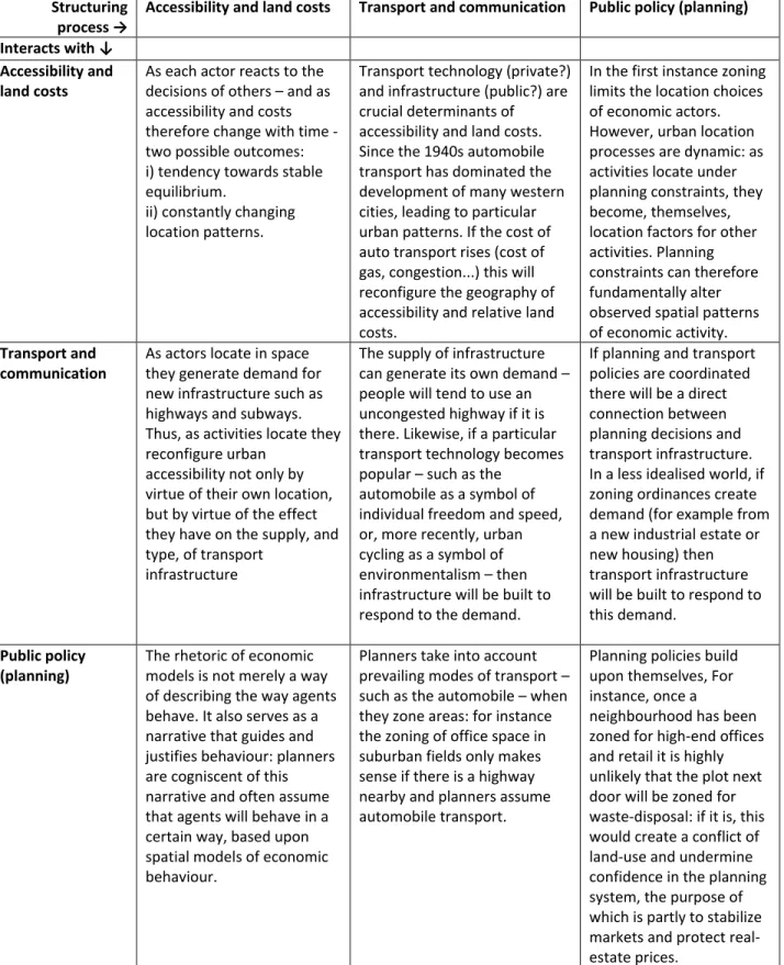
Table 1: Interactions between three types of process that structure the geography of urban economies Structuring
process →
Accessibility and land costs Transport and communication Public policy (planning)
Interacts with ↓ Accessibility and land costs
As each actor reacts to the decisions of others – and as accessibility and costs therefore change with time - two possible outcomes: i) tendency towards stable equilibrium.
ii) constantly changing location patterns.
Transport technology (private?) and infrastructure (public?) are crucial determinants of accessibility and land costs. Since the 1940s automobile transport has dominated the development of many western cities, leading to particular urban patterns. If the cost of auto transport rises (cost of gas, congestion...) this will reconfigure the geography of accessibility and relative land costs.
In the first instance zoning limits the location choices of economic actors. However, urban location processes are dynamic: as activities locate under planning constraints, they become, themselves, location factors for other activities. Planning constraints can therefore fundamentally alter observed spatial patterns of economic activity.
Transport and communication
As actors locate in space they generate demand for new infrastructure such as highways and subways. Thus, as activities locate they reconfigure urban
accessibility not only by virtue of their own location, but by virtue of the effect they have on the supply, and type, of transport
infrastructure
The supply of infrastructure can generate its own demand – people will tend to use an uncongested highway if it is there. Likewise, if a particular transport technology becomes popular – such as the
automobile as a symbol of individual freedom and speed, or, more recently, urban cycling as a symbol of environmentalism – then infrastructure will be built to respond to the demand.
If planning and transport policies are coordinated there will be a direct connection between planning decisions and transport infrastructure. In a less idealised world, if zoning ordinances create demand (for example from a new industrial estate or new housing) then transport infrastructure will be built to respond to this demand.
Public policy (planning)
The rhetoric of economic models is not merely a way of describing the way agents behave. It also serves as a narrative that guides and justifies behaviour: planners are cogniscent of this narrative and often assume that agents will behave in a certain way, based upon spatial models of economic behaviour.
Planners take into account prevailing modes of transport – such as the automobile – when they zone areas: for instance the zoning of office space in suburban fields only makes sense if there is a highway nearby and planners assume automobile transport.
Planning policies build upon themselves, For instance, once a
neighbourhood has been zoned for high-end offices and retail it is highly unlikely that the plot next door will be zoned for waste-disposal: if it is, this would create a conflict of land-use and undermine confidence in the planning system, the purpose of which is partly to stabilize markets and protect real-estate prices.
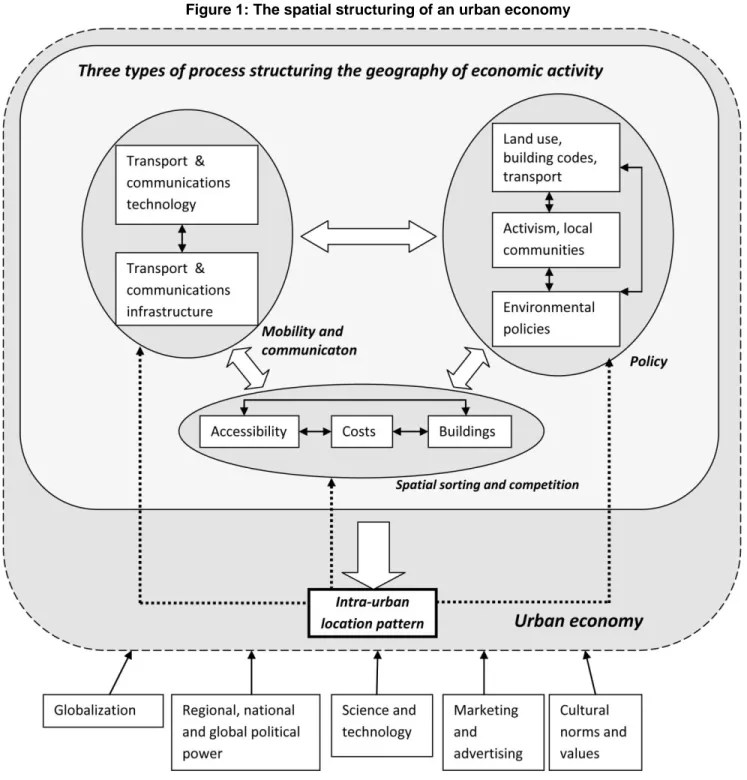
To summarise the key processes invoked in this section, Table1 details the three types of process that contribute to structuring the location of economic activity in urban areas, and Figure 1 provides a schematic illustration of how they combine to generate a city‟s spatial economic structure. Both the table and the figure highlight the fact that the processes are not straightforward: Table 1 provides an outline of the way in which each process influences itself (by way of feedback), and influences the other processes (as the outcomes of one process become factors to be taken into account in the two other processes). This outline is intended merely as an example: other processes may also be at work, and interactions may be more complex. However, most studies of the spatial structures of the urban economy rest upon the idea that these three processes interact to generate observable (and evolving) spatial patterns.
Figure 1, whilst making more explicit the way in which these processes lead to urban patterns, also shows that urban patterns retroact upon the processes that generate them. This can be due to dynamic processes (such as local agglomeration economies, local „buzz‟, or the clustering of particular social classes) or to processes of inertia in the built environment (once particular building types or infrastructure occupy and connect spaces they condition future development by their very presence). Furthermore, and in acknowledgement of the arguments raised by theorists - such as Dear (2003), Soja (1989, 1995), Harvey (1973) - the processes identified by urban economists as being key to the spatial structuring of the urban economy are themselves conditioned by factors operating well beyond the urban realm.
Indeed, it is at this point that „common-sense‟ analysis of urban structures often parts company with theorists. For whereas few empirical researchers would deny the importance of the factors that have been positioned outside of the urban economy in Figure 1 - factors such as globalization processes, political power at levels beyond the urban, cultural factors (to name but three of them) – much empirical analysis takes place in abstraction from these wider considerations. This not only renders the questions that are explored more tractable, it also enables researchers to develop useful – if circumscribed – knowledge and understanding of how economies develop across space within cities. The processes and interactions depicted in Figure 1 serve to reconcile – to some extent at least – the „common-sense‟ and the theoretical approaches to urban structures: for whereas theoretical approaches can tackle certain more fundamental questions (but ultimately also need to limit their scope of enquiry9) this is often at the expense of providing explanation for the day to day decision making of economic actors which, in the short to medium term, fashion observed spatial configurations in cities.
9
Ultimately theory rests upon belief systems, themselves a systematization of a fundamental ontology: short of undertaking metaphysical enquiries, the limits of theory are reached when ontological statements become necessary.
Observed spatial patterns of the urban economy
Given the processes just outlined, it is possible to briefly summarize the various ways in which urban economies have developed across space over the last century.
The early twentieth century was characterised by industrial cities, as portrayed by Park et al (1925). These cities – themselves bearing the imprint of pre-industrial structures - had in common a number of elements. First, transport was essentially pedestrian. Public transport systems had begun to emerge in the second half of the nineteenth century, but these – often horse-drawn buses, and, later, rail, streetcar and subways – were still limited in scope and relatively expensive for most workers (Giuliano & Hanson, 2004). Second, most long distance transport was organised around railways and ports, as was virtually all bulk transport: limitations in intra-urban land transport and fixed points of delivery for long-distance haulage limited the location options for most economic activities. Third, and in common with cities since antiquity (Pinol, 2003), powerful institutions lay at the geographic centre of the city. Indeed, the geographic centrality of power is an important thread that runs through most of urban history: whether the source of power be religious, military or economic, cities have tended to grow and develop around a central core, itself defined by a cathedral, a castle, a market place or – in industrial and post-industrial times – by government, financial services and corporate skyscrapers. In terms of the processes described in Table 1 and Figure 1, the central location of power can be interpreted – from an economic viewpoint – as the spatial result of agents‟ willingness to pay for good accessibility to the institutions of power. Conversely, agents of power – in a Benthamite way – seek to have maximum access to the resources and image they require to project their power – reinforcing their own geographic centrality10.
Given these conditions, the monocentric city described by Burgess (1925) can be interpreted as a prototypical industrial city (see Figure 2)11. The Central Business district is the focus of power (government, finance, business headquarters) which – incidentally – is taken as given in the model. All other activity locates relative to this centre in concentric rings. Such rings – assuming no geographic barriers – make sense if movement is at a similar speed in all directions – which is usually the case if walking is the main mode of transport. Communications being poor, and railways and water transport systems usually converging close to the CBD – industrial activity is located in the ring closest to the CBD. This location provides factories with good access to the metropolitan labour market, and also with good access to transport terminals and to financial and other services (such as warehousing, wholesale markets, etc..). Beyond these two economic zones lie residences of increasing socio-economic status: factory labourers, often in precarious and low
10 This serves to emphasise the radical nature of Soja‟s (1989) and Dear & Flusty‟s (1998) contention that centrality is no longer
associated with power.
11 Burgess‟s (1925) model was not primarily economic, though it has served as the basis for economic models such as Alonso‟s
paid employment, require physical proximity to job opportunities, and in order to obtain this crowd into small accommodations in proximity to employers. Wealthier families, able to afford larger houses and higher transport costs tend to live further out. Finally, a commuter zone – still in its infancy relative to today‟s metropolitan areas – is located at the outskirts of the metropolitan area. In sum, and given the industrial structures and transport infrastructure that existed in the early twentieth, the monocentric city reflects, in an idealised fashion, the balance between the economic processes included under „transport‟ and „spatial sorting and competition‟ in Figure 1.
Figure 2: Monocentric city, after Park & Burgess 1925
Note: A monocentric city symmetric in all directions supposes equal accessibility in all directions (walking speed?) and a single point of attraction (the CBD which coincides with train stations and water transport terminals). Economic activity is primarily located in the first two rings, though Lewis (2002) points out that suburbanisation of certain manufacturing activities occurred early. It should also be pointed out that proto-industrialisation occurred in dispersed fashion in rural areas (Hall, 1999).
Figure 3: Monocentric city with convergent transport network and Hoyt’s (1942) sectors
Note: the monocentric city is an idealised model. Transport networks shape (and distort) accessibility to the centre. Furthermore Hoyt (1939) and Lösch (Dicken & Lloyd, 1990) point out that related activities develop along transport axes, leading to wedge-shaped patterns of development along key transport routes from the centre.
CB D
Figure 4: Polycentric city (Harris & Ullman, 1945) with dominant CBD
Note: similar types of economic activity share similar infrastructure, real estate requirements and labour forces. As accessibility constraints loosen (transport is increasingly by car, truck and container) the requirement for many manufacturing and warehouse activities to be close to the centre is relaxed. Similarly, workers can gain access to suburban employment poles. There is increasing separation between place of residence and place of work, with the formation of suburban employment centres.
CB D
Figure 5: Polycentric city, edgeless cities and less dominant CBD
Note: as the automobile becomes ubiquitous suburban employment centres grow and expand along highways. Furthermore, these centres no longer only encompass airports and manufacturing/warehouse activities, but also increasingly include high-order service, retail and other consumption activities (Garreau, 1991; Stanback, 1991; Shearmur et al, 2007). The extent of the CBD’s influence is declining, and the suburbs are increasingly organised around employment centres and major highways.
CB D Airport
Figures 2 to 5 illustrate the evolution of idealised metropolitan urban patterns during the twentieth century. Figure 2, as just discussed, replicates Burgess‟s (1925) concentric pattern. It is important to note that this pattern captures a moment in the development of metropolitan areas, and is an arbitrary starting point. Prior to large monocentric industrial cities such as Chicago were smaller cities centered on markets, governments or religious institutions, with proto-industrial production occurring in rural areas. It is only the rise of large-scale factory production and the decline in agricultural employment that led to the concentration of both production and labour in large cities, each an attraction to, and attracted, by the other (Hall, 1999).
Figure 3 is a modification to the idealised pattern presented in Figure 2, but the processes that lead to the pattern remain spatial sorting, transport infrastructure and – to some extent at least – politics. Indeed, this figure shows how accessibility to the CBD is facilitated along (planned) key transport axes (which tended to converge towards the centre – particularly prior to the rise of the automobile when these axes were primarily rail or bus routes). However, another location factor is introduced: economic activity itself attracts other similar activity as the division of labour and specialisation leads to localisation economies. Since accessibility is facilitated along radial transport networks, complementary economic activities develop in segments along these routes, leading, for example, to light manufacturing along the Lachine canal to the West of Montreal‟s CBD, artisans stretching north along the St.Laurent boulevard and heavy industry, port activity and oil refining east along the St.Laurence river (Shearmur, 2011; Lewis, 2000). It should be noted that Lösch (Dicken & Lloyd, 1990) theorised this type of radial process for economic activities along transport networks at the regional scale, and Hoyt (1939) observed it for housing types and socio-economic groups at the intra-metropolitan scale.
As transport networks develop, so the monocentric pattern becomes superimposed with other patterns, but these patterns can still be explained by the basic processes posited in Figure 1. Figure 4 illustrates the emergence of suburban employment poles, the economic equivalent of Harris & Ullman‟s (1945) suburban centres. These employment poles often grow around key manufacturers who, faced with changing transport methods (in particular containerisation and truck haulage along publically funded highways) and changing production technologies (the most efficient production techniques required processes to take place on a single level) moved to suburban locations. Such moves had been occurring since the late nineteenth century (Lewis, 2000), but became the norm in the 1950s and 1960s. The move to the suburbs was also facilitated by the suburbanisation of housing and the increased motorisation of most households: suburban factory sites were now easily accessible to labour. Suburban economic activity tended to be polarised because of planning considerations (industrial estates were set aside for economic development), infrastructure (sites required good highway access), basic communication (without
internet or video-conferencing physical proximity between suppliers, service providers and other economic actors remained important), and industrial structure (large firms dominated the economy).
This polycentric urban pattern appears little changed in Figure 5, but important changes nevertheless occurred between the 1960‟s (which the patterns in Figure 4 can be said to approximate) and the 1990‟s (Figure 5). First, the nature of activities in suburban centres changed: from being essentially production oriented (with certain personal services to cater for the growing suburban population), suburban centres became increasingly service-oriented, leading Garreau (1991) to coin the term „edge-cities‟ and Stanback (1991) „suburban downtowns‟. This is a key change, because from being complementary to the CBD suburban centres were increasingly seen as competing with it. There is considerable debate about the extent of this phenomenon: whereas there is little doubt that high-order services and headquarters moved massively out of some of the US‟s CBDs, there is far less evidence that this has occurred in Canadian (Shearmur & Coffey, 2002) or European (Shearmur & Alvergne, 2002) cities12. Whereas processes governing the location of economic activity in European and Canadian cities continued to be essentially those illustrated in Figure 1 and Table 1, in the US considerable social changes have occurred. As poor black populations moved from rural areas into cheaper central area housing, and thereafter slowly moved outwards to better housing as their incomes improved, white populations abandoned central cities and immediate suburbs to move to outer suburbs (Hanlon, 2010). Their employers followed – leading to a downward spiral of poverty, decay and abandonment in the centre of many US cities, exacerbated by manufacturing decline and the rise of the service economy (Frey, 1979). Thus „cultural values‟ – one of the factors that is not usually taken into account by urban economists when describing the processes driving the location of economic activity in cities – are of importance to understanding US cities during this period. A second difference between the employment centres in Figure 4 and those in Figure 5 is that they are taking on a greater organising role: residential and commercial activity is increasingly locating relative to these suburban centres and less so in relation to the CBD (Garreau, 1991). Infrastructure is also being built that is no longer necessarily radial but that takes into account, and reinforces, the suburban employment patterns. Likewise planning decisions evolve in recognition of the growing trend towards suburban, and particularly highway driven, development, itself facilitated by the rise in importance of small companies and outsourcing (Scott, 1988).
12 Of course high-order services have grown in suburban locations in most cities, but it is only in some US cities that core high-order
services have left the centre. Much suburban high-order service growth in countries other than the US is attributable to the rapid proliferation of these activities and increasing differentiation (both in terms of function and location) within this category of economic activity. The highest order and most prestigious service providers still remain central.
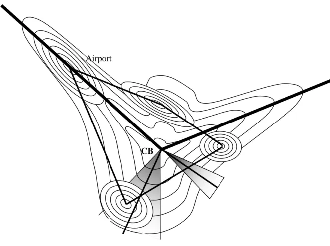
Figure 6: Polycentric city with scattered employment and outside influences?
Note: access to other cities and global networks is important. This is achieved through strategic location along highways, proximity to airport, or through telecommunications from scattered locations. Some economic activity is therefore scattered or located far from apparent centres along highways (Gordon & Richardson, 1996; Lang, 2003). Local urban patterns remain but are increasingly re-shaped by highway networks. Many suburban poles are centred on consumption rather than production functions. The structuring influence of the CBD is declining and power no longer necessarily locates there (Soja, 1989; Dear & Flusty, 1998).
Another factor hinted at in Figure 5 and fully illustrated in Figure 6 – one raised by Soja (1989, 1995) when he claims that the periphery is organising the centre – is the degree to which the CBD is losing its symbolic power as its capacity to organise space wanes. As cities grow (many North American cities have trebled in size since the 1950s), it is almost a foregone conclusion that the CBD – even if it grows moderately – will become smaller in relation to the rest of the metropolitan area. Thus, it is not sufficient to observe the relative decline of the CBD to conclude that its centrality is waning. Of more relevance is the location of command functions – high-order services focussed on global markets, key ministries, and financial activities. In most cities these remain in the downtown cores (see footnote 7), which are increasingly being revitalised as loci of
Airpor t
consumption activities, gentrified residences, as well as command functions (Jayne, 2006; Lees, 2011). However, in some cities – and Los Angeles may be one of them – they are dispersing across the region‟s sub-centres.
These differences may stem from two factors. On the one hand, certain cities – such as Los Angeles – have developed more recently than others. Thus, the story told in this paper does not apply in the same way to all cities: whereas cities such as Montreal and Chicago have evolved from industrial monocentric cities (Figure 1) to polycentric cities with strong CBDs (Figure 5), Los Angeles never really developed a monocentric base. Its logic of accessibility has almost always been premised on the automobile – leading to an inherently weaker CBD, and amplifying the patterns described in Figures 5 and 6. On the other hand, weaker CBDs (and the move of power to the suburbs) may, in certain US cities, be a consequence of the social upheavals described above. Given the shock that certain US central cities (such as Detroit) underwent as white flight combined with industrial decline prevented their renewal, so the desirability and centrality of the CBD was fundamentally altered: unlike in cities where the CBD has never undergone such a shock13, the CBD no longer acts – at least for now, but this may change (Lees, 2011) - as the locus of power, and accessibility to the CBD is no longer desired (Brueckner et al 1999).
In other words, even if most western industrial cities that first grew in the 19th century probably developed through the stages described in Figures 2 to 5, these stages do not necessarily describe the patterns that will be observed in cities that began to grow fast at a later date. Likewise, they will not necessarily describe cities where certain parts (such as the CBDs in many US cities) have undergone differential shocks relative to others – such as an impulse, driven by factors exogenous to the location processes described in Figure 1, to move out of the CBD and to move into the suburbs. Such an impulse will not only have a short term effect whilst it lasts, but will in all likelihood alter the spatial development trajectory of the affected cities.
The pattern shown in Figure 6 should therefore not be seen as the necessary next stage following on from Figure 5. It is probable that old industrial cities will continue to reflect the patterns illustrated in Figure 5, whilst of course being subjected to the newer forces that are shaping the location patterns of economic activity in Figure 6. Younger cities, that are more malleable or that– like Los Angeles – are not strongly influenced by a mono-centric past, may increasingly develop along the lines shown in Figure 6. In Figure 6 it is still spatial sorting, mobility and policy that are the key processes shaping the city. However, accessibility to the CBD is no longer more important in shaping the city than access to certain suburban employment poles. With an
13
It should be noted that this (negative) shock to the CBD is different from the (positive) one undergone by the suburbs: in cases of a city‟s total destruction previous patterns may well re-emerge (Davis & Weinstein, 2002).