Titre:
Title
:
Climate-informed environmental inflows to revive a drying lake
facing meteorological and anthropogenic droughts
Auteurs:
Authors
:
Aneseh Alborzi, Ali Mirchi, Hamed Moftakhari, Iman Mallakpour,
Sara Alian, Ali Nazemi, Elmira Hassanzadeh, Omid Mazdiyasni,
Samaneh Ashraf, Kaveh Madani, Hamid Norouzi, Marzi
Azarderakhsh, Ali Mehran, Mojtaba Sadegh, Andrea Castelletti et
Amir AghaKouchak
Date: 2018
Type:
Article de revue / Journal articleRéférence:
Citation
:
Alborzi, A., Mirchi, A., Moftakhari, H., Mallakpour, I., Alian, S., Nazemi, A., ... AghaKouchak, A. (2018). Climate-informed environmental inflows to revive a drying lake facing meteorological and anthropogenic droughts. Environmental Research Letters, 13(8), p. 1-13. doi:10.1088/1748-9326/aad246
Document en libre accès dans PolyPublie
Open Access document in PolyPublie
URL de PolyPublie:
PolyPublie URL: https://publications.polymtl.ca/4743/
Version: Version officielle de l'éditeur / Published versionRévisé par les pairs / Refereed Conditions d’utilisation:
Terms of Use: CC BY
Document publié chez l’éditeur officiel
Document issued by the official publisher
Titre de la revue:
Journal Title: Environmental Research Letters (vol. 13, no 8)
Maison d’édition:
Publisher: IOP Publishing
URL officiel:
Official URL: https://doi.org/10.1088/1748-9326/aad246
Mention légale:
Legal notice:
Ce fichier a été téléchargé à partir de PolyPublie, le dépôt institutionnel de Polytechnique Montréal
This file has been downloaded from PolyPublie, the institutional repository of Polytechnique Montréal
LETTER • OPEN ACCESS
Climate-informed environmental inflows to revive a
drying lake facing meteorological and
anthropogenic droughts
To cite this article: Aneseh Alborzi et al 2018 Environ. Res. Lett. 13 084010
View the article online for updates and enhancements.
Related content
The role of storage capacity in coping with intra- and inter-annual water variability in large river basins
Franziska Gaupp, Jim Hall and Simon Dadson
-Sustainability of global water use: past reconstruction and future projections Yoshihide Wada and Marc F P Bierkens
-Small-scale catchment analysis of water stress in wet regions of the U.S.: an example from Louisiana
Hisham Eldardiry, Emad Habib and David M Borrok
Environ. Res. Lett. 13 (2018) 084010 https://doi.org/10.1088/1748-9326/aad246
LETTER
Climate-informed environmental inflows to revive a drying
lake facing meteorological and anthropogenic droughts
Aneseh Alborzi1 , Ali Mirchi2,3, Hamed Moftakhari1, Iman Mallakpour1 , Sara Alian3,4, Ali Nazemi5 ,
Elmira Hassanzadeh6 , Omid Mazdiyasni1, Samaneh Ashraf1, Kaveh Madani7,8 , Hamid Norouzi9,10,
Marzi Azarderakhsh11, Ali Mehran12, Mojtaba Sadegh13 , Andrea Castelletti14and Amir AghaKouchak1,15,16
1 Department of Civil and Environmental Engineering, University of California, Irvine, United States of America
2 Department of Civil Engineering and Center for Environmental Resource Management, University of Texas at El Paso, El Paso, TX,
United States of America
3 Department of Biosystems and Agricultural Engineering, Oklahoma State University, Stillwater, OK, United States of America 4 Department of Geological Sciences, The University of Texas at El Paso, El Paso, TX, United States of America
5 Department of Building, Civil and Environmental Engineering, Concordia University, Montréal, Quebec, Canada 6 Department of Civil, Geological and Mining Engineering, Polytechnique Montr´eal, Quebec, Canada
7 Centre for Environmental Policy, Imperial College London, London, United Kingdom 8 Department of Physical Geography, Stockholm University, Stockholm, Sweden
9 New York City College of Technology, City University of New York, Brooklyn, NY, United States of America
10 Department of Earth and Environmental Sciences, The Graduate Center, City University of New York, New York, NY, United States of
America
11 School of Computer Science and Engineering, Fairleigh Dickinson University, Teaneck, NJ, United States of America 12 Department of Geography, University of California, Los Angeles, CA, United States of America
13 Department of Civil Engineering, Boise State University, Boise, ID, United States of America 14 Department of Electronics, Information, and Bioengineering, Politecnico di Milano, Milano, Italy 15 Department of Earth System Science, University of California, Irvine, United States of America 16 Author to whom any correspondence should be addressed.
OPEN ACCESS
RECEIVED
4 April 2018
REVISED
18 June 2018
ACCEPTED FOR PUBLICATION
10 July 2018
PUBLISHED
27 July 2018
Original content from this work may be used under the terms of the Creative Commons Attribution 3.0 licence. Any further distribution of this work must maintain attribution to the author(s) and the title of the work, journal citation and DOI.
E-mail:amir.a@uci.edu
Keywords: Lake Urmia, anthropogenic drought, climate variability and change, sustainable water resources management, restoration,
environmental inflow requirement
Supplementary material for this article is availableonline
Abstract
The rapid shrinkage of Lake Urmia, one of the world
’s largest saline lakes located in northwestern
Iran, is a tragic wake-up call to revisit the principles of water resources management based on the
socio-economic and environmental dimensions of sustainable development. The overarching goal of
this paper is to set a framework for deriving dynamic, climate-informed environmental inflows for
drying lakes considering both meteorological/climatic and anthropogenic conditions. We report on
the compounding effects of meteorological drought and unsustainable water resource management
that contributed to Lake Urmia
’s contemporary environmental catastrophe. Using rich datasets of
hydrologic attributes, water demands and withdrawals, as well as water management infrastructure
(i.e. reservoir capacity and operating policies), we provide a quantitative assessment of the basin
’s
water resources, demonstrating that Lake Urmia reached a tipping point in the early 2000s. The lake
level failed to rebound to its designated ecological threshold (1274 m above sea level) during a
relatively normal hydro-period immediately after the drought of record (1998–2002). The collapse
was caused by a marked overshoot of the basin
’s hydrologic capacity due to growing anthropogenic
drought in the face of extreme climatological stressors. We offer a dynamic environmental inflow plan
for different climate conditions (dry, wet and near normal), combined with three representative water
withdrawal scenarios. Assuming effective implementation of the proposed 40% reduction in the
current water withdrawals, the required environmental inflows range from 2900 million cubic meters
per year (mcm yr
−1) during dry conditions to 5400 mcm yr
−1during wet periods with the average
being 4100 mcm yr
−1. Finally, for different environmental inflow scenarios, we estimate the expected
recovery time for re-establishing the ecological level of Lake Urmia.
1. Introduction
Global fresh water resources are under growing pressure due to over-allocation of surface water (V¨or¨osmarty et al 2000, Hoekstra et al 2012) and groundwater resources (Wada et al2010, Gleeson et al 2012, Ashraf et al2017). The compounding effects of human-centered water management and global envi-ronmental changes in the Anthropocene have altered the natural hydrologic cycle by changing the quan-tity and quality of water, as well as changing the time scale of the processes that replenish water resources (V¨or¨osmarty et al 2010, Mirchi et al 2014, Nazemi and Wheater2014,2015a,2015b, Hassanzadeh et al 2015, Mehran et al2017). The disruption of regional water regimes around the globe due to increasing water stress is evident in the growing number of inland water bodies that are facing ecological degradation, especially in irrigated agricultural areas (e.g. Coe and Foley2001, Micklin2007, Ma et al2010, UNEP2012, Hatchett et al2015, Barnum et al2017).
Prime examples of drying terminal lakes in endorheic basins include the Aral Sea in Central Asia (Micklin1988), Walker Lake and Great Salt Lake in the US (Wurtsbaugh et al2017), Lake Chad in Africa (Gao et al2011), and Lake Urmia in northwestern Iran (AghaKouchak et al 2015). These alarming cases of lake level decline as well as other less dramatic inci-dents have been subjects of climate change scenario and impact assessments around the world (e.g. Coe and Foley2001, Schwartz et al2004, Ma et al 2010, Mohammed and Tarboton2012, Shadkam et al2016). Water level serves as a key indicator of a lake’s stabil-ity (Ma et al2010). Lake level fluctuations depend on intra- and inter-annual hydrologic variability (Mei et al 2015) and water management practices in the lake basin (Coe and Foley 2001, Ma et al 2010). Determining whether the lake level change is primarily due to human factors or climate change bears important implications for lake restoration strategies. In theory, the chance of preserving lakes will be higher if human activities are the chief reason for the water level decline because of opportunities for taking real actions to improve water management in the lake basin.
The shrinkage of Lake Urmia, to less than 20% of its average size (i.e. more than 5000 km2) over the last two decades (see AghaKouchak et al2015, Farzin et al2012, Pengra2012) is a recent exemplar of an emerging chal-lenge related to unsustainable water management in the face of growing demand and climatic extremes. This designated UNESCO ecosystem and one of the largest saline lakes (Sima and Tajrishi 2013, Karbassi et al 2010) is located at the bottom of an approximately 52 000 km2 basin in northwestern Iran (figure 1), which is home to about five million people close to international borders with Turkey, Iraq, and Azer-baijan (IME2013). With salinity levels ranging from six to approximately eight times higher than seawater, this shallow terminal lake is the largest natural habitat
for brine shrimp Artemia (Artemia Urmiana), which attracts diverse species of migratory birds (Barigozzi
et al1987, Vahed et al2011, Ahmadi et al2011). Such
massive decline in a lake area has been witnessed before in the Aral Sea Basin, where diverting Amu Darya and Syr Darya rivers during the Soviet era caused the lake to shrink to less than 10% of its original size (Micklin 1988,2007, Gaybullaev et al2012). Remarkable paral-lels between unsustainable water resource management in the Lake Urmia and Aral Sea basins reinforce spec-ulations of ‘the Aral Sea syndrome’ being a key driver of Lake Urmia’s collapse (AghaKouchak et al2015), causing negative impacts on both wildlife and humans (Madani et al2016, Yamaguchi et al2012).
The contemporary environmental catastrophe in the Lake Urmia Basin is a tragic wake-up call to rethink the water resources management paradigm in water-scarce countries based on hard-learned lessons about the social, economic, and environmental dimensions of sustainability (Madani 2014). Since the onset of the lake’s shoreline recession around the turn of the 21 century, many researchers have investigated vari-ous aspects of the problem (Gholampour et al2015, Ghaheri et al 1999, Ahmadzadeh Kokya et al 2011, Barigozzi et al1987, Delju et al2013, Nikbakht et al 2013). The desiccation has been primarily attributed to climate change-induced meteorological droughts (e.g. Fathian et al2015, Vaheddoost and Aksoy2017, Arkian
et al2018), as well as anthropogenic drought due to
supply-oriented water management (e.g. Hassanzadeh
et al2012, AghaKouchak et al 2015, Shadkam et al
2016, Zarghami and AmirRahmani2017, Ghale et al 2018). These studies have provided a high-level under-standing of the problem, highlighting the need for and complexities of synergistic efforts to revive a drying lake that is effectively struggling with ‘water bankruptcy’ (Madani et al2016). As shown in figure2, the drastic water level decrease after 1998 corresponds to a sub-stantial increase (∼25%) in surface water withdrawals to meet upstream potable and agricultural demands, which coincided with 48% decrease in runoff during the prolonged drought of 1998–2002. The largest water withdrawal of 4.75 bcm yr−1, of which 2.7 bcm yr−1was supplied from surface water was triggered by rapid agricultural expansion (i.e. 14% increase in irrigation area; IME2014). The figure also illustrates the basin’s recent wet (blue) and dry (red) periods as indicated by the standardized precipitation index (SPI; McKee et al 1993) and the variability of naturalized runoff.
This study attempts to inform the ongoing debate about the causes of Lake Urmia’s shrinkage and the planned restoration efforts. It provides a quantitative assessment of the basin’s water resources and envi-ronmental water requirement as influenced by wet and dry periods, and anthropogenic water withdrawals. Understanding the large-scale interplay of green water losses (i.e. consumptive water uses in the agricul-tural sector) and blue water availability (i.e. surface water and groundwater) (Allan 1998, Hoekstra and
Environ. Res. Lett. 13 (2018) 084010
Figure 1. Lake Urmia Basin showing its 117 sub-basins, existing dams and the lake’s surface area. The white boundary displays the
lake’s surface area in 1998 based on Landsat imagery. The second boundary depicts the current condition based on 2017 Landsat imagery (the dark blue area shows the region where water can be confidently detected from space).
Figure 2. Key attributes of the lake-basin system prior to restoration program in 2013, including observed lake level, standardized
precipitation index (SPI), basin-scale naturalized runoff, and surface water withdrawal. The basin’s recent wet (blue) and dry (red) periods are illustrated in SPI and naturalized runoff curves. Post-1998 drop in lake level corresponds to a substantial increase (∼25%) in surface water withdrawals during the prolonged drought of 1998–2002.
Hung2002, Falkenmark and Rockstr¨om2004) super-imposed by climate stressors in the basin is essential for effective restoration of Lake Urmia and preempt-ing similar incidences in other areas. Re-establishpreempt-ing Lake Urmia’s ecological integrity provides a testbed to
evaluate different lake restoration policies and action plans to curb and reverse the unfolding crisis. We examine the compounding effects of climate anomalies and anthropocentric water withdrawals in this highly regulated basin to restore the lake’s designated ecologi-3
cal water level of 1274 meters above sea level (masl) used as a monthly and annual threshold based on water quality conditions (240 g l−1of NaCl) required to preserve brine shrimp Artemia (Abbaspour and Nazari-doust 2007). We develop an understanding of lake level changes using comprehensive datasets of water resources management infrastructure (i.e. reservoir capacity and operating policies), observed streamflow data, and agricultural and urban water demand data from 117 sub-basins. The paper illustrates the need for developing a dynamic, climate informed environ-mental inflow plan to restore the lake’s ecological level. Furthermore, we investigate the lake’s expected recov-ery time under dynamic basin-scale water management scenarios compounded with a wide range of historical climatological conditions.
2. Methodology and data
We divided the Lake Urmia Basin into 117 sub-basins (see figure1), ranging from 16 km2to 3000 km2 (aver-age sub-basin size: 405 km2). The sub-basins were delineated based on the presence of streamflow gauges and/or dams as an outlet (i.e. Pour Point). For each sub-basin, we used observed streamflow data to represent the combined contribution of surface runoff and base-flow. Instead of calculating irrigation water use through estimated soil moisture (i.e. from a hydrological or a land-surface model) implemented in previous basin-scale analyses of this lake (e.g. Shadkam et al2016), we used a sub-basin scale dataset of monthly agricultural water demands developed by local water authorities based on irrigated area and crop water requirement (IME2014). Thus, we accounted for green water losses over the basin and consequent reduction of the blue water flow to the lake. Likewise, the municipal and industrial demands at the sub-basin scale were obtained based on available monthly observational data (IME 2013).
MODSIM-DSS, a generalized network flow river basin model (Fredericks et al1998, Labadie and Larson 2007) applied for this study, distributes the available water based on natural inflows, water demands, reser-voir capacities and operating policies, and calculates the lake level based on excess water flow to the lake. This modeling tool has been widely used for basin-scale water resources planning (Graham et al 1986, Sprague and Carlson1982, Ahn et al2016, Berhe et al 2013, Ashraf Vaghefi et al2017), and it is able to rep-resent the supply/demand priorities. We coupled the sub-basin scale water resource system model with a monthly lake water balance model to better represent lake-basin interactions. Table1summarizes key input datasets and sources.
The developed MODSIM-DSS model includes 17 large on-stream and off-stream operational reservoirs (i.e. capacity >5 mcm). These reservoirs collectively store up to 1560 mcm of water, providing 97% of
the total surface storage capacity in the basin (see figure S1 in supplementary materials) available at stacks.iop.org/ERL/13/084010/mmedia. Physical char-acteristics and operating policies embedded in model inputs include: (i) volume-area-elevation curves, (ii) net evaporation rate, (iii) maximum, minimum and initial reservoir capacities, and (iv) reservoir water allocation priorities. Where cascaded reservoirs are present, the model is capable of simulating basin-scale coordinated operation of the reservoirs, i.e. upstream-downstream coordination to meet down-stream demands. Without these reservoirs, updown-stream water could reach the lake quickly, rendering an inac-curate representation of water availability in different parts of the basin. We used river discharge mea-surements and observed lake levels to validate the simulated basin-lake interactions. Simulated lake lev-els and lake inflows closely track the observational data (see figures S2 through S4 in supplementary materials), indicating reasonable model performance, also suggested by model efficiency coefficients (e.g. (i) monthly lake inflow correlation coefficient (0.96), bias (15.5%), and Nash–Sutcliffe efficiency coefficient (0.9), and (ii) monthly lake level correlation coefficient (0.96), bias (0.03%), and Nash–Sutcliffe efficiency coef-ficient (0.79)). Depending on the time of measurement, lake level elevation varies from 1270 m to 1278 masl with average elevation being 1275 masl (average depth: 5.4 m).
For the lake scenario analyses (discussed below), a normal year is assumed to receive 350 mm of rainfall (IME 2013, ULRP 2016). Furthermore, we used monthly evaporation climatology with annual evaporation of 1100 mm yr−1 (ULRP 2016) for the simulation period. This simplification was necessary due to unavailability of monthly evaporation time series for the entire simulation period. To validate this assumption, we compared the performance of the MODSIM-DSS model using both monthly evapora-tion climatology and available monthly evaporaevapora-tion time series for the period of 1982–2002 for which we had access to monthly lake evaporation. The com-parison illustrates that lake levels are consistent with observations using monthly evaporation climatology (figure S5 in supplementary materials). Water demand is partially met using groundwater up to an observed rate of 2000 mcm yr−1(IME2014). Given the lack of long-term records, we used different constant annual rates, but considering the monthly distributions for each sub-basin based on observations (IME 2014). Under different water withdrawal scenarios, the annual groundwater withdrawals vary between 1650 mcm yr−1 to 2000 mcm yr−1to supplement surface water supply. We acknowledge that lack of groundwater withdrawal time series introduces uncertainties in the simulations. We simulated the interactions between the upstream water resource system and Lake Urmia under scenarios that cover a wide range of climate condi-tions and water withdrawals combined (figure3). The
Environ. Res. Lett. 13 (2018) 084010
Table 1. Datasets used for simulating the basin-lake interactions (Source: various publications of IME).
Dataset Spatial scale Temporal scale
Lake level-volume-area curve — —
Over-lake evaporation and precipitation Meteorological stations Monthly average (1967–2012)
Surface water supply Streamlines Monthly (1967–2007)
Surface water withdrawals and irrigated area Sub-basin Monthly (2012)
Groundwater withdrawals Sub-basin Monthly mean (2012)
model uses naturalized runoff data to allocate water to different demand nodes. We estimated the natu-ralized runoff for each sub-basin by adding long-term upstream surface water withdrawals (including return flow) to streamflow gauge at the sub-basin outlet. The climatological scenarios are based on historic climate observations including baseline and near normal cli-matology and an observed historic drought (i.e. 48% decrease in runoff). The baseline period (1994–1998) is a relatively wet period that precedes the drastic decrease in the lake area. The most extreme drought condi-tion corresponds to 1998–2002 (hereafter, referred to as drought of record scenario). We consider 2003–2007 a near normal period after the 1998–2002 drought because natural runoff during this period is close to long-term mean (1967–2012, 6500 mcm yr−1). Water demand scenarios include historical baseline, maxi-mum demand, and target demand reduction. Baseline demand refers to pre-drastic change in lake levels and water withdrawals (i.e. pre-1998). Maximum demand is associated with rapid increase in the overall water withdrawals (i.e. 2003–2012) and it is the most extreme case investigated in our analysis. Target demand is based on the recommendation of the Urmia Lake Restoration Program (ULRP2016) that calls for an aggressive 40% decrease in 2013 agricultural water use over a 5 year period (ULRP2016). The combination of these scenarios helps evaluate the compounding effects of climatic and anthropogenic conditions on the lake’s water level.
For all nine coupled scenarios (i.e. permutations of three inflow scenarios and three demand scenarios) depicted in figure3, we investigated both basin-scale water stress and associated changes in the lake level. We used a modified version of the water resources vulnera-bility index (Raskin et al1997), in which environmental flow allocations are included in water stress index (WSI) calculations alongside Human Water Withdrawals (see Smakhtin et al 2005, Averyt et al2013, Pastor et al 2014). The dimensionless WSI characterizes the stress imposed on the total water resources defined as the summation of both available surface water and ground-water resources (Raskin et al1997, V¨or¨osmarty et al 2005).
WSI = HWW + EFATWR (1) The modified water resources vulnerability index accounts for environmental withdrawals in the water stress index formulation. A WSI of 0.6 represents a moderately exploited basin and WSI values above this
threshold indicate that the basin is heavily exploited (Smakhtin et al2005). Here, we consider the environ-mental inflow requirement of 3100 mcm yr−1 as Lake Urmia’s annual ecological demand in the historical sce-narios (Abbaspour and Nazaridoust2007). The lake’s required ecological flows were not delivered reliably prior to the implementation of the restoration plan in 2013 due to lower priority of environmental flow com-pared to human water use. Furthermore, we evaluate the sensitivity of the minimum inflow requirement to lake level dynamics as a critical boundary condition for effective re-establishment of the target ecological level of the lake.
3. Results and discussion
3.1. Assessment of climate-demand scenarios Figure4summarizes the WSI over the basin along with the percentage of change in the lake’s level relative to baseline under the combined climate-demand scenar-ios. The results show high water stress under all nine scenarios. The basin-wide WSI under an intention-ally optimistic scenario of wet period combined with ULRP target demand stands at an alarming level of 60% (i.e. moderately exploited basin). The WSI increases to about 80% under maximum observed demand dur-ing wet period, indicatdur-ing heightened vulnerability in a heavily exploited basin. A similar increasing trend is detected during the near normal period when the WSI exceeds 80%. In an extremely dry period, in which the annual runoff reduces by 48% (compared to the baseline wet period), the lake is gravely vulnerable to increases in anthropogenic water demands, elevating the WSI to a distressing level of 90%. Percentages of annual change in lake depth (relative to baseline) over the five-year simulation periods (1994–1998, 1998– 2002 and 2003–2007) show an increasingly divergent, declining trend of lake-basin interactions under near normal and dry period scenarios, compounded with larger water demand scenarios. The increasing range in boxplots corresponding to change in lake level (figure 4) illustrates higher vulnerability of the lake to human water withdrawals in dry condition.
In a wet climate and under the maximum demand scenario, the lake level drops by 10%, which high-lights the significance of anthropogenic demand alone on the lake water depth. However due to ample surface runoff during a wet period, the lake level remains above the prescribed ecological threshold. Unlike the wet period, the lake is vulnerable to anthro-5
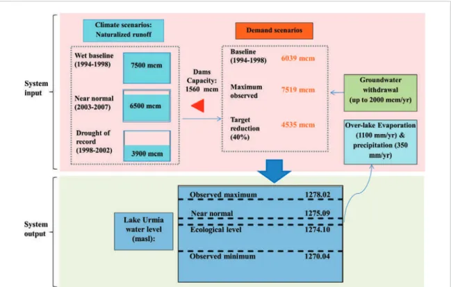
Figure 3. MODSIM-DSS model inputs and outputs along with climate and demand scenarios.
Figure 4. WSI in percentage over the lake basin (green boxplot) and the percentage of change in the lake level relative to the baseline
(gray boxplot) under different combinations of climate-demand scenarios. Shaded regions represent wet baseline (purple), near normal (yellow), and dry (pink) periods. Dashed vertical lines demarcate three demand scenarios (i.e. target reduction (40%), baseline, and maximum historical) in each period.
pogenic demand during a near normal condition and the lake-basin interactions under the ULRP tar-get demand will be at a fragile hydrologic balance. This means that any rise in demand above the tar-geted values leads to lake level dropping below the ecological threshold. Notably, even a 5% increase
in water demand during the near normal condition pushes the lake level below the ecological level. Expect-edly, the largest decline in the lake level (i.e. 1.5 m drop below the ecological threshold) occurs during the dry period with maximum observed demand, which is the most extreme case in our analysis. This result confirms
Environ. Res. Lett. 13 (2018) 084010
the ‘double devil effect’ of 25% increase in water with-drawal in the Lake Urmia Basin during the drought of 1998–2002 that pushed the lake water budget severely out of balance and caused a lasting, drastic drop in the lake level (figure4).
3.2. Lake level departure from the ecological thresh-old
Figure5illustrates the sensitivity of lake level to dif-ferent combinations of total available water resources (including both surface water and groundwater) and total water withdrawal over the basin. The contours were derived from lake level as a model output under different simulation scenarios, which depends on water withdrawals (x-axis) and available water resources (y-axis). It is important here to distinguish between basin-scale total water withdrawal and water demand; total water withdrawal depends on the water availabil-ity in the basin, and therefore, it may be smaller than the total water demand. With a low supply reliabil-ity of 55%–80% (IME2013), the Lake Urmia Basin faces water deficit, which necessitates water use restric-tions. Sectoral water demands are met according to ordinal allocation priorities of domestic, industrial, agricultural, and finally environmental needs. Total water availability (5500 mcm) and water withdrawal (3500 mcm) over the basin during the drought of 1998–2002 caused the lake level to fall to around the 1273.5 contour line (figure5(a)), which is consistent with the observed lake level in the aftermath of this prolonged drought.
We examined the sensitivity of the lake’s environ-mental inflow requirement to initial lake level as a boundary condition in order to quantify the implica-tions for maintaining the lake’s ecological level. Figure 5(b) illustrates the results of lake level contours under coupled climate-withdrawal scenarios for initial lake levels of 1275 masl, 1274 masl, and 1273 masl, which represent water levels above, at, and below the ecologi-cal level, respectively. The lake’s ability to absorb water stresses while remaining above the critical threshold (i.e. safe ecological zone) declines significantly when the initial lake level decreases as indicated by dra-matic decline of the estimated lake level. In the case of low initial water volume, a moderate withdrawal in a near normal climate condition may drive the lake level below the critical ecological threshold. This effect is seen in the post-drought scenario when low runoff for three consecutive years resulted in lake level decline (1373.5 masl) below the critical level. Although the region had near-normal precipitation and runoff immediately after the drought of record (i.e. during the 2003–2012 period), the lake levels continued to fall due to growing water withdrawal and failure to increase the lake’s environmental inflow. These results demonstrate the need to prescribe dynamic, climate-informed envi-ronmental inflow requirements to sustain the lake as opposed to the existing, static ecological water demand of 3100 mcm yr−1.
3.3. Lake Urmia’s tipping phase and recovery trajec-tory
Lake Urmia reached a tipping point in the early 2000s when the lake basin’s hydrologic carrying capacity was significantly exceeded due to compounding pressures from climatological factors and unsustainable water management practices. Improved understanding of the compounding stressors will be critical to devise an effec-tive restoration process for implementation within a realistic timeframe. The remarkable contrast between lake level simulations under natural (i.e. excluding anthropogenic withdrawals) and existing conditions reveals the critical role of anthropocentric water man-agement in creating this environmental catastrophe. The lake’s severely disrupted water balance failed to rebound after the drought of record because the cumu-lative effect of the routine practice of increasing water diversions to keep up with growing upstream water demand acted as ‘the last straw that broke the camel’s back.’ Our simulations show that by 1998, total water withdrawals in the basin had already overshot the basin’s hydrologic capacity to sustain the lake, although in reality, water withdrawals continued to increase beyond 1998 levels. Even water withdrawals 40% lower than 2012 withdrawals (i.e. target withdrawal reduc-tion for restorareduc-tion) would not have been sufficient to prevent a significant decline in the lake level below the ecological level immediately after the drought of record, although the reduction would have markedly ameliorated the situation. Simulation results show that maintaining the lake’s ecological level would have been attainable by keeping water withdrawals 55% lower than the 2012 levels.
The key structural and non-structural restoration measures set forth by the ULRP include re-connecting the tributaries and the lake, major water transfers from trans-boundary river basins (e.g. Zab and Silveh Dam), limiting additional water withdrawal in the basin, and paying farmers to fallow the surrounding agricultural lands, among others (ULRP2016). Water conserva-tion practices in various demand sectors across the lake basin will be crucial for moving in the direction of recovery and should be prioritized. This is particularly important based on the lessons learned from imple-menting various inter-basin water transfer projects to address water shortage problems in the central plateau of Iran, where the problems have persisted despite arti-ficial increase of surface water supply (Gohari et al2013, Gohari et al2017). Adoption of low water consuming crops (e.g. grape) in the basin along with increasing irri-gation efficiency with the ultimate goal of reducing net water consumption can facilitate the attainment of an ambitious 40% decrease in withdrawals as prescribed by the ULRP (ULRP2016).
Our analysis suggests that the ULRP timeline is overambitious (figure 7). Depending on climatic conditions and assuming effective implementation of the proposed 40% reduction in the current water withdrawal, the required environmental inflows 7
Figure 5. Average lake level contours under different combinations of water availability and water withdrawals with the initial lake
level fixed at 1274 masl (a), and when the initial lake level is changed as a variable boundary condition (b).
Figure 6. Lake Urmia level under different water withdrawal scenarios. The natural system simulation (i.e. no anthropogenic
withdrawals) and different withdrawal scenarios illustrate the overshoot of the basin’s hydrologic carrying capacity to sustain the lake due to anthropocentric water management after an extreme drought.
Environ. Res. Lett. 13 (2018) 084010
Figure 7. Environmental inflow along with estimated timeframe to restore to ecological level (1274 masl), considering 20% and 40%
decrease in water withdrawals over the basin, given the initial lake level of 1270.7 masl. Long-term mean (i.e. 1967–2012) naturalized runoff in the Lake Urmia Basin is estimated at 6500 mcm yr−1).
range from 2900 mcm yr−1 (during dry conditions) to 5400 mcm yr−1 (during wet conditions) with the average being 4100 mcm yr−1. Under a more realis-tic 20% water withdrawal reduction these values are estimated to range from 3100 mcm yr−1 (during dry conditions) to 4900 mcm yr−1(during wet conditions) with the average being 4000 mcm yr−1. Despite restora-tion efforts after 2013, the lake level in 2017 was more than 3 m below the ecological threshold after reaching a post-collapse maximum of 1271.3 masl that has been attributed to implementation of a stabiliza-tion phase from 2014–2016, and large precipitastabiliza-tion events in a relatively normal hydroclimatic period. Enforcement of the 40% decrease in agricultural water withdrawals through purchasing water rights within a five-year period starting in 2015 is a key measure of the ULRP during the rehabilitation phase (i.e. 2017– 2022). Using the observed lake level in 2017 as the initial condition, we investigated the sensitivity of the lake’s ecological level recovery timeline to reducing the agricultural water withdrawals by projecting lake level into the future under different climate scenarios. Figure7shows that under scenarios of increased aridity, when meeting the environmental inflow requirement of the lake will be difficult, restoring the ecological level can take up to 16 years, even if the proposed 40% reduction in agricultural water withdrawal is realized. Failing to reduce agricultural water with-drawals and/or providing the environmental inflows will result in delaying the attainment of the ecological level.
The lake is currently in grave need of receiving ade-quate environmental inflows. The natural flow regime (Poff et al1997) provides a theoretical framework for
implementing ecosystem-based water management in the Lake Urmia sub-basins to mitigate adverse socio-ecological impacts. To this end the ULRP includes radical proposals to revive the lake, e.g. operating the reservoirs exclusively for lake restoration pur-poses, as well as improving the monitoring and regulation of surface water and groundwater with-drawals (ULRP 2016). However, transitioning to an ecosystem-based water management paradigm by meeting dynamic environmental inflows in the Lake Urmia Basin is evidently difficult because of the pres-ence of multi-sectoral tradeoffs (e.g. financial losses to stakeholders and population redistribution) that put the agricultural economy and socio-ecological sustainability at odds. On the one hand, the water resources that are exploited beyond the basin’s nat-ural supply capacity are supporting agrarian and urban livelihoods with significant green and blue water foot-prints (Hoekstra and Chapagain 2006, Mekonnen and Hoekstra 2011). On the other hand, the loss of tourism (Maleki et al2018) and potential public health effects due to salt blowouts from the exposed lake bed (Griffin and Kellogg 2004) are side-effects that have considerable socioeconomic implications. The high water stress even during wet periods under-scores the prevalence of a chronic anthropogenic drought. To cope with this situation, investigating an ‘environmental hedging’ approach guided by hydro-logic and biohydro-logic forecasting (Adams et al 2017) may offer a practical strategy to facilitate progress towards ecological recovery of the lake while meet-ing human demands within the constraints of basin scale water availability and ecological functions of Lake Urmia.
4. Conclusions
The Lake Urmia Basin in northwestern Iran is an exemplar of how unsustainable water management to meet growing water demand can create massive socio-ecological challenges. We developed a detailed water resources systems model of the basin to investigate the causes of Lake Urmia’s shrinkage based on a quantita-tive assessment of the water balance under wet and dry periods and water withdrawal scenarios. Furthermore, we evaluated potential effectiveness of the planned restoration measures. Our simulations include com-prehensive datasets of water resources management infrastructure (i.e. reservoir capacity and operating policies), observed streamflow data, and agricultural and urban water demand data from 117 sub-basins. Results demonstrate that a growing anthropogenic drought combined with meteorological drought drove the lake toward a state of hydrological overshoot and collapse. The rapid water level decline after the drought of record (1998–2002) when annual runoff decreased by 48% is synchronous with an approximately 25% increase in surface water withdrawals, especially in the agricultural sector, which continued long after signs of the lake’s tipping phase appeared. The lake level remained significantly below the designated ecologi-cal threshold ( m above sea level) even in a relatively normal period immediately after the drought. In the absence of the unsustainable water resources devel-opment and growing anthropogenic water stress, the lake would have resisted the climatologic shock without collapsing.
Re-establishing Lake Urmia’s ecological integrity requires aggressive restoration policies and action plans aimed at maintaining environmental inflows in the face of compounding climate anoMalies and water withdrawals. A dynamic and climate-informed envi-ronmental inflow plan is critical for reviving the lake. Taking into account both climatic conditions and assuming the already proposed 40% reduc-tion in the current water withdrawals, we estimate that the lake’s environmental inflow requirements range from 2900 mcm yr−1 (during dry conditions) to 5400 mcm yr−1 (during wet conditions) with the average being 4100 mcm yr−1. These estimates for a more realistic 20% water withdrawal reduction would be 3100 mcm yr−1 (during dry conditions) to 4900 mcm yr−1(during wet conditions) with the aver-age being 4000 mcm yr−1. Depending on the climatic condition, water withdrawal reduction plan, and envi-ronmental releases, Lake Urmia’s recovery time can range from 3 to 16 years.
ORCID iDs
Aneseh Alborzi https://orcid.org/0000-0003-2233-889X
Iman Mallakpour https://orcid.org/0000-0001-6869-7615
Elmira Hassanzadeh https://orcid.org/0000-0002-9393-5715
Kaveh Madani https://orcid.org/0000-0003-0378-3170
Ali Nazemi https://orcid.org/0000-0002-8393-5519 Mojtaba Sadegh https://orcid.org/0000-0003-1775-5445
References
Abbaspour M and Nazaridoust A 2007 Determination of environmental water requirements of Lake Urmia, Iran: an ecological approach Int. J. Environ. Stud.64 161–9
Adams L E, Lund J R, Moyle P B, Quĩnones R M, Herman J D and O’Rear T A 2017 Environmental hedging: theory and method for reconciling reservoir operations for downstream ecology and water supply Water Resour. Res.53 7816–31
AghaKouchak A, Norouzi H, Madani K, Mirchi A, Azarderakhsh M, Nazemi A and Hasanzadeh E 2015 Aral Sea syndrome desiccates Lake Urmia: call for action J. Great Lakes Res.41
307–11
Ahmadi R, Mohebbi F, Hagigi P, Esmailly L and Salmanzadeh R 2011 Macro-invertebrates in the wetlands of the Zarrineh estuary at the south of Urmia Lake (Iran) Int. J. Env. Res.5
1047–52
Ahmadzadeh Kokya T, Pejman A, Mahin Abdollahzadeh E, Ahmadzadeh Kokya B and Nazariha M 2011 Evaluation of salt effects on some thermodynamic properties of Urmia Lake water Int. J. Environ. Res. 5 343–8
Ahn S R, Jeong J H and Kim S J 2016 Assessing drought threats to agricultural water supplies under climate change by combining the SWAT and MODSIM models for the Geum River basin, South Korea Hydrolog. Sci. J.61
2740–53
Allan J A 1998 Virtual water: a strategic resource global solutions to regional deficits Groundwater36 545–6
Arkian F, Nicholson S E and Ziaie B 2018 Meteorological factors affecting the sudden decline in Lake Urmia’s water level Theor. Appl. Climatol.131 641–51
Ashraf Vaghefi S, Abbaspour K C, Faramarzi M, Srinivasan R and Arnold J G 2017 Modeling crop water productivity using a coupled SWAT–MODSIM model Water9 157
Ashraf B, AghaKouchak A, Alizadeh A, Baygi M M, Moftakhari H R, Mirchi A and Madani K 2017 Quantifying anthropogenic stress on groundwater resources Sci. Rep.7 12910
Averyt K, Meldrum J, Caldwell P, Sun G, McNulty S, Huber-Lee A and Madden N 2013 Sectoral contributions to surface water stress in the coterminous United States Environ. Res. Lett.8
35046
Barigozzi C, Varotto V, Baratelli L and Giarrizzo R 1987 The artemia of Urmia Lake (Iran): mode of reproduction and chromosome numbers Atti Accad. Naz. Lincei Cl. Sci. Fis. Mat. Nat. Rend. Ser. 8 81 87–90
Barnum D A, Bradley T, Cohen M, Wilcox B and Yanega G 2017 State of the Salton Sea—A science and monitoring meeting of scientists for the Salton Sea (USGS Numbered Series No. 2017–1005) (Reston, VA: US Geological Survey) Berhe F T, Melesse A M, Hailu D and Sileshi Y 2013
MODSIM-based water allocation modeling of Awash River Basin Ethiopia CATENA109 118–28
Coe M T and Foley J A 2001 Human and natural impacts on the water resources of the Lake Chad basin J. Geophys. Res.: Atmos.106 3349–56
Delju A, Ceylan A, Piguet E and Rebetez M 2013 Observed climate variability and change in Urmia Lake Basin, Iran Theor. Appl. Climatol.111 285–96
Environ. Res. Lett. 13 (2018) 084010
Falkenmark M and Rockstr¨om J 2004 Balancing Water for Humans and Nature: the New Approach in Ecohydrology (London: Earthscan) p 247
Farzin S, Ifaei P, Farzin N, Hassanzadeh Y and Aalami M 2012 An investigation on changes and prediction of Urmia Lake water surface evaporation by chaos theory Int. J. Environ. Res.6
815–24
Fathian F, Morid S and Kahya E 2015 Identification of trends in hydrological and climatic variables in Lake Urmia Basin, Iran Theor. Appl. Climatol.119 443–64
Fredericks Jeffrey W, Labadie John W and Altenhofen Jon M 1998 Decision support system for conjunctive stream-aquifer management J. Water Res. Pl. Asce.124 69–78
Gao H, Bohn T J, Podest E, McDonald K C and Lettenmaier D P 2011 On the causes of the shrinking of Lake Chad Environ. Res. Lett.6 034021
Gaybullaev B, Chen S-C and Kuo Y-M 2012 Large-scale desiccation of the Aral Sea due to over-exploitation after 1960 J. Mt. Sci.9
538–46
Ghaheri M, Baghal-Vayjooee M and Naziri J 1999 Lake Urmia, Iran: a summary review Int. J. Salt Lake Res.8
19–22
Ghale Y A G, Altunkaynak A and Unal A 2018 Investigation anthropogenic impacts and climate factors on drying up of Urmia Lake using water budget and drought analysis Water Resour. Manage.32 325–37
Gholampour A, Nabizadeh R, Hassanvand M S, Taghipour H, Nazmara S and Mahvi A H 2015 Characterization of saline dust emission resulted from Urmia Lake drying J. Environ. Health Sci. Eng.13 82
Gleeson T, Wada Y, Bierkens M F and van Beek L P 2012 Water balance of global aquifers revealed by groundwater footprint Nature488 197–200
Gohari A, Mirchi A and Madani K 2017 System dynamics evaluation of climate change adaptation strategies for water resources management in central Iran Water Resour. Manage.
31 1413–34
Gohari A, Eslamian S, Mirchi A, Abedi-Koupaei J, Massah Bavani A and Madani K 2013 Water transfer as a solution to water shortage: a fix that can backfire J. Hydrol.491 23–39
Graham L P, Labadie J W, Hutchison I P G and Ferguson K A 1986 Allocation of augmented water supply under a priority water rights system Water Resour. Res.22 1083–94
Griffin D W and Kellogg C A 2004 Dust storms and their impact on ocean and human health: dust in Earth’s atmosphere EcoHealth1 284–95
Hassanzadeh E, Zarghami M and Hassanzadeh Y 2012 Determining the main factors in declining the Lake Urmia level by using system dynamics modeling Water Resour. Manage.26
129–45
Hassanzadeh E, Elshorbagy A, Wheater H, Gober P and Nazemi A 2015 Integrating supply uncertainties from stochastic modeling into integrated water resource management: a case study of the Saskatchewan River Basin ASCE J. Water Resour. Plan. Manage.27 05015006
Hatchett B J, Boyle D P, Putnam A E and Bassett S D 2015 Placing the 2012–2015 California-Nevada drought into a paleoclimatic context: insights from Walker Lake, California–Nevada USA Geophys. Res. Lett.42 8632–40
Hoekstra A Y and Hung P Q 2002 Virtual water trade: a quantification of virtual water flows between nations in relation to international crop trade Value of Water Research Report Series 11 166, UNESCO-IHE
Hoekstra A Y, Mekonnen M M, Chapagain A K, Mathews R E and Richter B D 2012 Global monthly water scarcity: blue water footprints versus blue water availability PLoS ONE7
e32688
Hoekstra A Y and Chapagain A K 2006 Water footprints of nations: water use by people as a function of their consumption pattern Integrated Assessment of Water Resources and Global Change ed E Craswell, M Bonnell, D Bossio, S Demuth and N Van De Giesen (Dordrecht: Springer) pp 35–48
Iran’s Ministry of Energy (IME), Deputy of Water and Wastewater, Macro Planning Bureau 2013 The National Water Master Plan Study in the Aras, Sefidrood, between Sefidrood and Haraz, Atrac and Urmia: Water allocation for the development projects in Urmia Lake Basin Report Number:
2385070-2050-24142, 2385070-2050-24142 (isi-mip.org) (Accessed: 24 March 2016)
Iran’s Ministry of Energy (IME), Deputy of Water and Wastewater, Macro Planning Bureau 2014 The National Water Master Plan Study in the Aras, Sefidrood, between Sefidrood and Haraz, Atrac and Urmia: agricultural water use study in Urmia Lake Basin Report Number: 2385070-4420-19464, 2385070-4420-19464 (isi-mip.org)
(Accessed: 24 March 2016)
Karbassi A, Bidhendi G N, Pejman A and Bidhendi M E 2010 Environmental impacts of desalination on the ecology of Lake Urmia J. Great Lakes Res.36 419–24
Labadie J W and Larson R 2007 MODSIM 8.1: River basin management decision support system: user manual and documentation (Accessed: 6 October 2014)
(ftp://dwrftp.state.co.us/cdss/projects/MODSIM/ MODSIMv8.1UserManual.pdf)
Ma R, Duan H, Hu C, Feng X, Li A, Ju W and Yang G 2010 A half-century of changes in China’s lakes: global warming or human influence? Geophys. Res. Lett.37 L24106
Madani K 2014 Water management in Iran: what is causing the looming crisis? J. Environ. Stud. Sci.4 315–28
Madani K, AghaKouchak A and Mirchi A 2016 Iran’s socio-economic drought: challenges of a water-bankrupt nation Iranian Stud.49 997–1016
Maleki R, Nooripoor M, Azadi H and Lebailly P 2018 Vulnerability assessment of rural households to Urmia Lake drying (the case of Shabestar region) Sustainability10
McKee T, Doesken N and Kleist J 1993 The relationship of drought frequency and duration to time scales Proc. 8th Conf. Applied Climatology, 17–22 January 1993 (Boston, MA: American Meteorological Society) pp 179–84
Mehran A, AghaKouchak A, Nakhjiri N, Stewardson M J, Peel M C, Phillips T J and Ravalico J K 2017 Compounding impacts of human-induced water stress and climate change on water availability Sci. Rep.7 6282
Mei X, Dai Z, Du J and Chen J 2015 Linkage between three Gorges Dam impacts and the dramatic recessions in China’s largest freshwater lake, Poyang Lake Sci. Rep.5 18197
Mekonnen M M and Hoekstra A Y 2011 The green, blue and grey water footprint of crops and derived crop products Hydrol. Earth Syst. Sci.15 1577
Micklin P 2007 The Aral Sea disaster Annu. Rev. Earth Pl. Sc.35
47–72
Micklin P P 1988 Desiccation of the Aral Sea: a water management disaster in the Soviet Union Science241 1170
Mirchi A, Watkins D W, Huckins C J, Madani K and Hjorth P 2014 Water resources management in a homogenizing world: averting the growth and underinvestment trajectory Water Resour. Res.50 7515–26
Mohammed I N and Tarboton D G 2012 An examination of the sensitivity of the Great Salt Lake to changes in inputs Water Resour. Res.48
Nazemi A and Wheater H S 2014 Assessing the vulnerability of water supply to changing streamflow conditions Eos, Trans. Am. Geophys. Un.95 288–8
Nazemi A and Wheater H S 2015a On inclusion of water resource management in Earth system models–Part 1: problem definition and representation of water demand Hydrol. Earth Syst. Sci.19 33–61
Nazemi A and Wheater H S 2015b On inclusion of water resource management in Earth system models-Part 2: representation of water supply and allocation and opportunities for improved modeling Hydrol. Earth Syst. Sci.19 63
Nikbakht J, Tabari H and Talaee P H 2013 Streamflow drought severity analysis by percent of normal index (PNI) in Northwest Iran Theor. Appl. Climatol.112 565–73
Pastor A V, Ludwig F, Biemans H, Hoff H and Kabat P 2014 Accounting for environmental flow requirements in global water assessments Hydrol. Earth Syst. Sci.18 5041–59
Pengra B 2012 The drying of Iran’s Lake Urmia and its environmental consequences UNEP-GRID (Sioux Falls: UNEP Global Environmental Alert Service) (https://na.unep. net/geas/getUNEPPageWithArticleIDScript.php?article _id=79)
Poff N L, Allan J D, Bain M B, Karr J R, Prestegaard K L, Richter B D, Sparks R E and Stromberg J C 1997 The natural flow regime: a paradigm for river conservation and restoration Bioscience 47 769–84
Raskin P, Gleick P, Kirshen P, Pontius G and Strzepek K 1997 Water futures: assessment of long-range patterns and problems Comprehensive Assessment of the Freshwater Resources of the World (Stockholm: SEI)
Schwartz R C, Deadman P J, Scott D J and Mortsch L D 2004 Modeling the impacts of water level changes on a Great Lakes community J. Am. Water Resour. Assoc.40 647–62
Shadkam S, Ludwig F, van Oel P, Kirmit C¸ and Rezaei Kabat P 2016 Impacts of climate change and water resources development on the declining inflow into Iran’s Lake Urmia J. Great Lakes Res.42 942–52
Sima S and Tajrishy M 2013 Using satellite data to extract volume–area–elevation relationships for Lake Urmia, Iran J. Great Lakes Res.39 90–9
Smakhtin V, Revenga C and D¨oll P 2005 Taking into Account Environmental Water Requirements in Global-scale Water Resources Assessments (International Water Management Institute)
Sprague R H Jr and Carlson E D 1982 Building effective decision support systems Prentice Hall Professional Technical Reference (Upper Saddle River, United States)
United Nations Environment Program (UNEP) 2012 The Drying of Iran’s Lake Urmia and its Environmental Consequences (http://na.unep.net/geas/getUNEPPageWithArticleID Script.php?article_id=79)
Urmia Lake Restoration Program (ULRP) 2016 Approved Solutions, the Executive Status and progress of projects 2 (http://ulrp.sharif.ir/sites/default/files/field/
files/02%20Urmia%20Lake%20Projects%20-%20% 2094.09.02.pdf) (Accessed: 10 March 2016) (in Persian) Vahed S Z, Forouhandeh H, Hassanzadeh S, Klenk H P, Hejazi M A
and Hejazi M S 2011 Isolation and characterization of Halophilic bacteria from Urmia Lake in Iran Microbiology80
834–41
Vaheddoost B and Aksoy H 2017 Structural characteristics of annual precipitation in Lake Urmia basin Theor. Appl. Climatol.128 919–32
V¨or¨osmarty C J, Douglas E M, Green P A and Revenga C 2005 Geospatial indicators of emerging water stress:
an application to Africa AMBIO: J. Hum. Environ.34
230–6
V¨or¨osmarty C J, Green P, Salisbury J and Lammers R B 2000 Global water resources: vulnerability from climate change and population growth Science289 284–8
V¨or¨osmarty C J et al 2010 Global threats to human water security and river biodiversity Nature467 555–61
Wada Y, van Beek L P, van Kempen C M, Reckman J W, Vasak S and Bierkens M F 2010 Global depletion of groundwater resources Geophys. Res. Lett.37
Wurtsbaugh W A, Miller C, Null S E, DeRose R J, Wilcock P, Hahnenberger M and Moore J 2017 Decline of the world’s saline lakes Nat. Geosci.10 816
Yamaguchi N, Sakotani A, Ichijo T, Kenzaka T, Tani K, Baba T and Nasu M 2012 Break down of Asian dust particle on wet surface and their possibilities of cause of respiratory health effects Biol. Pharm. Bull.35
1187–90
Zarghami M and AmirRahmani M 2017 A system dynamics approach to simulate the restoration plans for Urmia Lake, Iran Optimization and Dynamics with their Applications ed A Matsumoto (Singapore: Springer) pp