HAL Id: hal-00922069
https://hal.archives-ouvertes.fr/hal-00922069
Submitted on 23 Dec 2013
HAL is a multi-disciplinary open access
archive for the deposit and dissemination of
sci-entific research documents, whether they are
pub-lished or not. The documents may come from
teaching and research institutions in France or
abroad, or from public or private research centers.
L’archive ouverte pluridisciplinaire HAL, est
destinée au dépôt et à la diffusion de documents
scientifiques de niveau recherche, publiés ou non,
émanant des établissements d’enseignement et de
recherche français ou étrangers, des laboratoires
publics ou privés.
SCATTERING MECHANISM ANALYSIS USING
MULTI-ANGULAR POLARIMETRIC RADARSAT-2
DATASETS
Hongquan Wang, Sophie Allain, Stéphane Meric, Eric Pottier
To cite this version:
Hongquan Wang, Sophie Allain, Stéphane Meric, Eric Pottier. SCATTERING MECHANISM
ANAL-YSIS USING MULTI-ANGULAR POLARIMETRIC RADARSAT-2 DATASETS. 6th International
Workshop and Science and Applications of SAR Polarimetry and Polarimetric Interferometry, ESA
Symposium, Jan 2013, Frascati, Italy. pp.1-6. �hal-00922069�
SCATTERING MECHANISM ANALYSIS USING MULTI-ANGULAR POLARIMETRIC
RADARSAT-2 DATASETS
Hongquan Wang1,2, Sophie Allain1
, St´ephane M´eric1,2, Eric Pottier1 1
SAPHIR team, Institute of Electronics and Telecommunications of Rennes (IETR)
2
INSA of Rennes, European University of Brittany
Campus Beaulieu, bldg 11D, 263 av. G´en´eral Leclerc, CS 74205, 35042 Rennes Cedex Email: [email protected]
ABSTRACT
The objective of this study is to analyze scattering mecha-nisms using multi-incidence angle observations over agri-cultural fields. Radarsat-2 datasets acquired in the end of March / beginning of April with four different ranges of incidence angle are explored using polarimetric decom-position methodology. The results show that single scat-tering is always the dominant scatscat-tering mechanism over test sites, although single scattering occurs on bare sur-face is significantly stronger than that occurs in vegeta-tion canopy. As incidence angle increases, single scatter-ing decreases, and volumetric scatterscatter-ing increase as ex-pected. Therefore, lower incidence angle acquisition is appropriate to characterize soil moisture over bare sur-face due to the limited effect of roughness, while higher incidence angle is suitable for surface roughness iden-tification over bare surface and plant height description over vegetation canopy. Nevertheless, as the incidence angle increases towards 40◦, a saturation occurs which
limits the application of images acquired using incidence angle bigger than40◦ to discriminate scattering
mecha-nism. The potential of polarimetric differences∆σHH in
dB, as well as ∆pr to characterize wheat height is also demonstrated. The combination of various incidence an-gles helps us to monitor crop growth cycle and also to get a better estimation of soil parameters.
Key words: multi-angular; scattering mechanism; target decomposition.
1. INTRODUCTION
Polarimetric SAR response from land cover can be sig-nificantly influenced by the following two parameter cat-egories: (1) Target parameters, such as soil moisture, roughness, soil texture and vegetation status; and (2) Sen-sor parameters, such as frequency, polarization and inci-dence angle. The sensor parameters are typically known in application. But the dependence of measured signals on target parameters must be investigated. Theoretical or
empirical models is normally used to convert the mea-sured backscattering coefficients into soil moisture and surface roughness. Therefore, there exists one equation with two unknowns for each target, three unknowns if the model incorporates the correlation length. Conse-quentially, the use of radar acquired with a single con-figuration does not generally allow for the estimation of these surface variables, even for bare surface. It is neces-sary to adopt multi-dimensional measurement including multi-angular, multi-polarization and multi-frequency. Retrieval of surface parameters from multi polarimetric SAR measurement has been extensively investigated in the past decades. One of the representative algorithms is established in [1], which relate the backscattering coef-ficients and co/cross polarization ratio directly with soil moisture and surface roughness using semi-empirical co-efficients. In addition, this work also investigates the pos-sibility to apply multi-frequency and multi-angular obser-vations. It was shown that the inversion accuracies of soil moisture and surface roughness can be improved signif-icantly using multi-angular configuration. However, this approach is just to make an average among multi-angular inversion results, and did not give physical-based inter-pretation of multi-angular configuration.
Multi-angular and multi-polarization configuration are compared in [2], indicating the sensitivity of multi-angular configuration to surface roughness is 10 times than multi-polarization, which encourage the continuous exploration of multi-angular models. But during the tem-poral span of multi-angular image acquisition, the surface soil moisture should remain nominally constant. This is an obvious constraint with currently orbiting radar sys-tems with can not acquire multi-angular image at the same time. Although these limits, study in [3] combined more than two images with different incidence angles to separate the effects of surface roughness and soil mois-ture for several tillage types.
The multi-angular behaviors of Oh model, Dubois mode, and GOM have been examined by [4]. [5] proposed an original surface roughness parameter to include hor-izontal and vertical roughness statistical information, and found that backscattering difference between two SAR
_____________________________________ Proc. ‘PolInSAR 2013’, Frascati, Italy
acquisitions depends more on surface roughness than soil moisture, in accordance with the results of [2]. Based on this original approach, more works have been fol-lowed, but most of them focus on the relation between backscattering differences and roughness. Further study of [6] suggested a usage of additional image acquired un-der dry condition, so this image is possible to consiun-der as a unique indicator of surface roughness. As a result, hor-izontal and vertical roughness can be separated respec-tively. It may be applicable to use [6] on arid or semi-arid region, but this is not the general case.
Furthermore, [7] indicates that small incidence angle con-figuration is more appropriate to invert soil moisture, big incidence angle is more appropriate to invert surface roughness. It has been tested that backscattering energy holds the linear relation with soil moisture and exponen-tial / logarithm with surface roughness. [8] reports that in sandy surface condition, back scattering coefficients are more sensitive to surface observable than clay surface. To separate the soil texture effect, an original ground soil moisture measurement method is proposed. However, the coefficients describing the linear, exponential or loga-rithm relationship are often different from one watershed to another and also from one year to next and need to be calibrated each time.
Compared to conventional retrieval approaches that eval-uate the total backscattering signature, the innovative soil parameter inversion algorithms focus more on scatter-ing mechanism quantification usscatter-ing target decomposi-tion technique. [9] proposed to apply entropy and al-pha angle derived from engen-decomposition methodol-ogy to characterize soil moisture. The SPM model has been extended to a larger application condition by rotate the coherence matrix T with an angle in order to repsent the surface roughness depolarization effect. [10] re-ports thatα1 derived from the first eigenvalue of Eigen-decomposition algorithm depends more on soil moisture than surface roughness and can be considered as a poten-tial parameter to retrieve soil moisture. Two original po-larimetric parameters SERD, DERD are defined to char-acterize the intensity differences among different scatter-ing mechanisms. [11] modifies the double bounce com-ponent and volumetric scattering comcom-ponent of Freeman decomposition algorithms. Then, the volumetric compo-nent is subtracted from the total power in order to make it possible to derive soil moisture under vegetation. The multi-angular application in [11] is to extend the obser-vation space for accuracy improvement, more than one image acquisition is necessary for a sufficient parameter-ization of the scattering scenario.
In this study, we aim to investigate the behaviors of 3 scat-tering mechanisms (single bounce, double bounce and volume scattering) under multi-incidence angle config-uration. Their relative difference are also examined in order to make a correlation with ground status. Then it is proposed to use the difference of polarimetric parameters between two incidence angle acquisitions to characterize wheat height.
Figure 1. Swaths of Radarsat-2: Red-20◦, Green-34◦,
Purple-40◦, Yellow-49◦, Blue-location of test sites
2. DATASETS OVER TEST SITE
The research is carried out in the site of Pleine-Foug`eres in France, as a large set of remote sensing data and con-tinuous terrain investigations are available in this region. The kind of surfaces are mainly agriculture fields and wetlands. While the present work is solely dedicated to explore the potential utilities of multi-angular polarimet-ric SAR images to characterize agpolarimet-ricultural crops.
Table 1. Multi-angular Radarsat-2 image acquisitions
Mode θnear(◦) θf ar(◦) Date (2011) Time
FQ2 20.0 21.8 27/3 06:31
FQ14 33.4 35.1 27/3 17:53
FQ20 39.2 40.7 31/3 06:14
FQ31 48.3 49.4 23/3 18:09
The Multi-angular Radarsat2 dataset listed in Table.1 are acquired at C band in Fine Quad polarization mode with a nominal swath width 25km, spatial resolution 5.2 m in range × 7.6 m in azimuth. In the end of March / be-ginning of April, many agricultural fields are coved by wheat, meadow and rape. The raw Radarsat2 images are extracted as coherence matrix T3, and a7×7 boxcar filter was applied using Posarpro4.2. Afterward, the polarimet-ric images were imported to NEST for Otho-rectification and co-registration. It should be noted that the co-registration is indispensable for multi-angular analysis, since the swaths as well as resolution are different in multi-angular acquisitions, as shown in Fig.1.
Ground truth measurements including volumetric soil moisture, crop type and height are synchronized over the same research fields, with the purpose to examine the sensitivities of polarimetric parameters to crop status de-scriptors in multi-angular mode. Nevertheless, due to the instability of prairie and grass, this crop hight study merely focuses on the agricultural field covered by wheat.
(a) (b)
(c) (d)
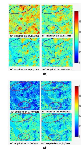
Figure 2. (a) Land cover, (b)Single bounce, (c)Double bounce, (d)Volume scattering
3. SCATTERING MECHANISM ANALYSIS
It is achievable to use incoherent target scattering de-composition to extract the optimum polarization informa-tion from multi-angular observainforma-tions. In this study, the H/A/alpha decomposition [12] and Vanzyl Non-negative eigenvalue decomposition approaches [13] are assessed for scattering mechanism analysis using multi-angular configurations. The 3 extracted scattering mechanism components are normalized to compare their relatively strength. Fig.2(a) shows the land use during the ground campaign period. Theinsitu measurements are carried out on both bare fields and the agricultural lands covered by grass, meadow, rape and wheat. After the vanzyl Non-negative decomposition, the normalized single scattering components are demonstrated in Fig.2(b) against 4 differ-ent incidence angles. It can be found that as the incidence angle increase, the single bounce decreases as expected.
However, if incidence angle becomes bigger than40◦, an
saturation phenomenon occurs. In contrary, the variation of double bounce components is not significant when the incidence angle variates, as shown in Fig.2(c). It can be noticed in Fig.2(d) that the volume scattering component increases with incidence angles, as expected. A variation saturation is observed also around40◦. This is because
in higher incidence angle, more canopy layer are exposed to SAR observation, and less underlying ground can be penetrated in C band. Nevertheless, if incidence angle continue to increase towards a specific threshold, such as 40◦ according observation, due to nominally
homo-geneous attribute of agricultural canopy medium, the 3 scattering mechanisms become less sensitive to incidence angle. Over the selected test sites, it can be observed that the single bounce is always the dominant scattering mechanism even for the vegetation fields, as this study was conducted in April, and most of agricultural fields were covered by small crop with less density.
20 30 40 50 0.5 0.6 0.7 0.8 0.9 0.4 0.5 0.6 0.7 0.8 0.9 Incidence angle(°) Entropy SERD Rough Smooth
Figure 3. Roughness separation using Entropy and SERD under multi-angular configuration
For bare surface or sparse vegetation fields, the multi-angular backscattering is mainly influenced by rough-ness and soil moisture. It is a common view that the key point of soil moisture inversion is to separate the effect of surface roughness. We explore the potential use of Entropy, SERD [10] in multi-angular configura-tion in Fig.3 to improve the surface roughness character-ization. Rougher land surface has a higher entropy and lower SERD. This is because as the increasing of single bounce, the decreasing of volume scattering, their differ-ence SERD decreases with inciddiffer-ence angle. Meanwhile, the rougher surface has a stronger depolarization effect than the smoother fields. Thus, the multi-incidence an-gle images increases the dimension to separate various roughness classes and have a potential to improve rough-ness characterization accuracy.
4. WHEAT HEIGHT CHARACTERIZATION
With the presence of vegetation canopy, the total backscattering signal composed of the soil surface scat-tering (σ0
soil), the vegetation volumetric scattering (σ 0 veg),
and the interaction between surface and vegetation diffu-sionσ0 inter[14]: σ0 tot= σ 0 veg+ γ 2 σ0 soil+ σ 0 inter (1) whereγ2
is the two-way transmissivity coefficient. However, σ0
inter is negligible in our application, as
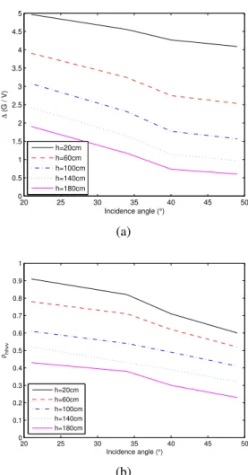
Radarsat-2 operates in C-band, the signal penetration ability is weaker than that in L band. Thus, the mul-tiple scattering term is to some extent lower than in L band. The vegetation canopy is assumed to be homoge-neous and with a constant height for a specific scene. The small scattering elements which are considered to consti-tute crop canopy with uniform spatial and orientational distributions, yield an azimuthally symmetric, homoge-neous crop layer. A two-scale model (large scale + small scale) is adopted for the underlying ground surface scat-tering:σ0 soil= σl+ σs[15]. 20 25 30 35 40 45 50 0 0.5 1 1.5 2 2.5 3 3.5 4 4.5 5 Incidence angle (°) ∆ (G / V) h=20cm h=60cm h=100cm h=140cm h=180cm (a) 20 25 30 35 40 45 50 0 0.1 0.2 0.3 0.4 0.5 0.6 0.7 0.8 0.9 1 Incidence angle (°) ρhhvv h=20cm h=60cm h=100cm h=140cm h=180cm (b)
Figure 4. (a)∆(G/V ), (b)ρhhvv to incidence angles in
vegetation height simulation
This simplified model is applied in our work as a forward scattering model to examine the behaviors of polarimet-ric parameters under multi-angular configuration. The simulation sets the sensor configuration as the same with Radarsat-2 operation parameters. The beneath surface is considered with a moderate roughness and soil moisture condition. The vegetation height is set as 20cm, 60cm, 100cm, 140cm, and 180cm respectively.
The following two polarimetric parameters are consid-ered in multi-angular mode:
The first one is the correlation between HH and VV chan-nel as it is reported in [16] that this correlation is highly sensitive to crop height regardless of crop type:
ρhhvv=
| < ShhSvv⇤ > |
p|Shh|2|Svv|2
(2)
Another novel polarimetric parameter is derived based on [11] to characterize vegetation height:
∆(G/V ) = λ1 P v −
λ2
P v (3)
whereλ1,λ2 are the eigenvalues of the coherence matrix after removal the volume component,P v is the volume scattering from Freeman decompostion[17]
It is shown in Fig.4(a) that ρhhvv decreases with
inci-dence angle, because the increase in inciinci-dence angle re-sults in an augmentation of volume scattering contribu-tion to the total backscattering signal. Therefore, the cor-relation between HH and VV decreases. The sensitivity ofρhhvvto crop height is also observable in Fig.4(a),
in-dicatingρhhvvholds an inverse relation with crop height.
This phenomenon can also be explained by the augmen-tation of volume contribution as crop height increases. The variation trend of ∆(G/V ) to incidence angle in Fig.4(b) is in agreement with the examination by [11]: ∆(G/V ) decreases as crop height increases regardless of crop type. In addition, polarimetric parameter∆(G/V ) becomes smaller in higher incidence angle configuration. The polarimetric parameters∆(G/V ) and ρhhvv are
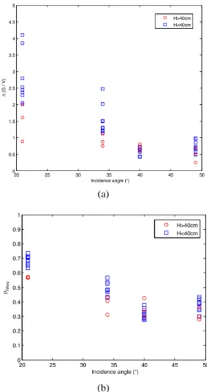
de-rived from Radarsart2 datasets, in term of crop height. The real multi-angular polarimetric SAR results pre-sented in Fig.5(a) and Fig.5(b) generally show the sim-ilar variation patterns with the simulation above. As the 3 scattering mechanisms is not sensitive to higher inci-dence angle, the polarimetric parameters∆(G/V ) and ρhhvv consequently become insensitive to wheat height
if incidence angle is bigger than40◦.
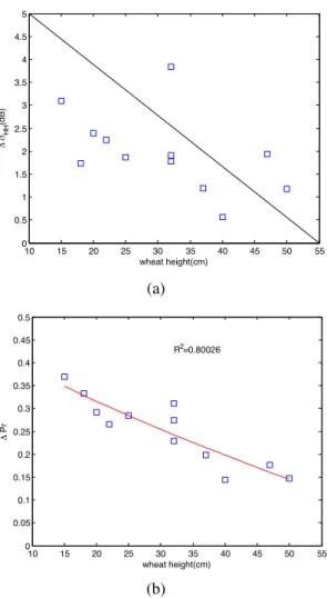
After the comparisons of various incidence angle behav-ior, it it achievable to integrate a multi-angular approach to characterize the land status. In this study, the po-larimetric difference between two incidence angles (21◦
and40◦) are analyzed to make a correlation with wheat
height. The first parameter is the backscattering coeffi-cients in HH channel,∆σhhin dB, since this parameter
has been examined to characterize the surface roughness for bare surface. When comes to crop land cover, we as-sume that crop height has a similar effect on∆σhh for
crop field, just as the effect of roughness on on∆σhhfor
bare surface. It is shown in Fig.6(a) thatδσHH in dB
de-creases with wheat height increasing. Another parameter is derived from the eigenvalues ofH/A/α target decom-postion algorithm: P r =r 3 2 s λ2 2+ λ 2 3 λ2 1+ λ 2 2+ λ 2 3
It is encouraging to observe that the∆P r decreases sig-nificantly with wheat height and their determinant coef-ficientR2
is around 0.8. Thus, these two multi-angular polarimetric parameters have a potential for wheat height characterization. These observations indicate that the lower wheat is more sensitive the incidence angle vari-ations. 20 25 30 35 40 45 50 0 0.5 1 1.5 2 2.5 3 3.5 4 4.5 5 Incidence angle (°) Δ (G / V) H>40cm H<40cm (a) 20 25 30 35 40 45 50 0 0.1 0.2 0.3 0.4 0.5 0.6 0.7 0.8 0.9 1 Incidence angle (°) ρhhvv H>40cm H<40cm (b)
Figure 5. (a)∆(G/V ), (b) ρhhvvfrom Radarsat-2
5. CONCLUSION
Via analyzing the behaviors of scattering mechanisms variations with incidence angle, this study shows that sin-gle bounce and volume scattering over test sites become saturated if incidence angle is bigger than40◦. The
En-tropy and SERD using multi-angular configuration have a potential to improve the roughness class separation. The scattering mechanism parameters ∆(G/V ) and ρhhvv
both decreases with incidence angle and they also sen-sitive to wheat height if incidence angle is less than40◦.
The difference in HH polarization channel between two incidence angle acquisitions is found to decrease with wheat height. The difference in polarimetric parameters P r between two incidence angle is observed to be more sensitive to wheat height with R2
= 0.8. These two multi-angular polarimetric parameters are found to have a potential to characterize crop status.
10 15 20 25 30 35 40 45 50 55 0 0.5 1 1.5 2 2.5 3 3.5 4 4.5 5 Δ σHH (dB) wheat height(cm) (a) 10 15 20 25 30 35 40 45 50 55 0 0.05 0.1 0.15 0.2 0.25 0.3 0.35 0.4 0.45 0.5 R2=0.80026 Δ Pr wheat height(cm) (b)
Figure 6. (a)∆σHHin dB, (b)∆P r against wheat height
ACKNOWLEDGMENTS
The authors would like to thank C´ecile Leconte and Fr´ed´eric Boutet for their help in ground truth measure-ments.
REFERENCES
[1] Y.Oh. Quantitative retrieval of soil moisture con-tent and surface roughness from multipolarized radar observations of bare soil surfaces. IEEE Trans.Geosci.Remote Sensing, 42:596–601, 2004. [2] B.Molineaux, A. Chanzy, and M. Zribi. Using
multi-angular radar data to discriminate the influ-ence of rough surface scattering on soil moisture in-versions over bare soils. In IGARSS, 1999.
[3] B. G. Colpitts. The integral equation model and surface roughness signatures in soil mois-ture and tillage type determination. IEEE Trans.Geosci.Remote Sensing, 36:833–837, 1998. [4] M. R. Sahebi and J. Angles. An inversion method
based on multi-angular approaches for estimating
bare soil surface parameters from radarsat-1.
Hy-drol. Earth Syst. Sci., 14:2355–2366, 2010. [5] M.Zribi and M.Dechambre. A new empirical model
to retrieve soil moisture and roughness from c-band radar data. Remote Sensing of Environment, 84:42– 52, 2002.
[6] M.M. Rahman, M.S. Moran, D.P. Thoma,
R. Bryant, C.D. Holifield Collins, T. Jackson, B.J. Orr, and M. Tischler. Mapping surface rough-ness and soil moisture using multi-angle radar imagery without ancillary data. Remote Sensing of
Environment, 112(2):391 – 402, 2008. ¡ce:title¿Soil Moisture Experiments 2004 (SMEX04) Special Issue¡/ce:title¿.
[7] N.Baghdadi, M.Zribi, C.Loumagne, P.Ansart, and T.P.Anguela. Analysis of terrasar-x data and their sensitivity to soil surface parameters over bare agri-cultural fields. Remote Sensing of Environment, 112:4370–4379, 2008.
[8] H.S.Srivastava, P.Patel, Y.Sharma, and R.R. Naval-gund. Large-area soil moisture estimation using multi-incidence-angle radarsat-1 sar data. IEEE Geoscience and Remote Sensing Letters, 47:2528– 2535, 2009.
[9] I.Hajnsek. Inversion of Surface Parameters using
Polarimetric SAR. PhD thesis, Friedrich-Schiller-Universitat Jena, 2001.
[10] S.Allain. Caracterisation d’un sol nu a partire de
donnes SAR polarimetriques etude multi-frequency et multi-resolutions. PhD thesis, Universite de Rennes 1, 2003.
[11] T. Jagdhuber. Soil Parameter Retrieval under
Veg-etation Cover Using SAR Polarimetry. PhD thesis, University of Potsdam, 2012.
[12] S.R.Cloude and E.Pottier. An entropy based classi-fication scheme for land applications of polarimetric SAR. IEEE Trans.Geosci.Remote Sensing, 35:68– 78, 1997.
[13] J.J. van Zyl, M. Arii, and Yunjin Kim. Model-based decomposition of polarimetric sar covariance matri-ces constrained for nonnegative eigenvalues.
Geo-science and Remote Sensing, IEEE Transactions on, 49(9):3452 –3459, sept. 2011.
[14] F.T. Ulaby, R. K.Moore, and A. K. Fung. Mi-crowave Remote Sensing Active and Passive - Vol-ume III -From Theory to Application. Artech House, 1986.
[15] M.L. Williams. A coherent, polarimetric sar simu-lation of forests for PolSARPro. Technical report, 2006.
[16] I.Gherboudj, R.Magagi, A.A. Berg, and B.Toth. Soil moisture retrieval over agricultural fields from multi-polarized and multi-angular radarsat-2 sar data. Remote Sensing of Environment, 115:33–43, 2011.
[17] A. Freeman and S.L. Durden. A three-component scattering model for polarimetric SAR data. IEEE