high-resolution ocean forecasting system
M. Juza1, B. Mourre1, L. Renault2, S. Gómara1, K. Sebastián1, S. Lora1, J.P.
Beltran1, B. Frontera1, C. Troupin1, M. Torner1, E. Heslop1, G. Vizoso3, B. Casas3
and J. Tintoré1,3
1 SOCIB, Parc Bit, Naorte, Bloc A 2ºp. pta. 3, 07 121 Palma de Mallorca, Spain.
2 UCLA, Atmospheric and Oceanic Sciences, Los Angeles, USA. 3 IMEDEA (UIB-CSIC), Esporles, Islas Baleares, Spain.
Abstract
The Balearic Islands Coastal Observing and Forecasting System (SOCIB) is a multi-platform distributed oceanic observatory providing both oceanographic data and modelling services to support the operational oceanography in the European and international framework. The Modelling and Forecasting Facility contributes to SOCIB objectives by both developing and maintaining operational forecasting systems and conducting scientific research to continuously support their improvement. Among these systems is the western Mediterranean high resolution operational ocean forecasting system WMOP, which provides temperature, salinity, sea level and currents predictions every day with a 2km and 3h resolution. Monitoring and validation procedures have been developed using multi-platform observations to systematically assess the model performance and to detect model errors at local, sub-basin and basin scales. The systematic validation routine allows to highlight both the general realism of the WMOP ocean forecasting system and sub-regional model errors. The 3-day forecast of physical ocean fields, data visualization and validation results are available on-line at www.socib.es.
Keywords: ocean forecasting system, high resolution model, multi-platform
observations, validation, western Mediterranean Sea
1. Introduction
The development of ocean forecasting systems contributes to respond to science and society needs. Indeed, global and regional ocean models can enhance the knowledge of the oceanic system through the understanding of physical processes and their impact on the general circulation. They also support decision making in the marine environment (security, transport, economy, protection, resources, fisheries, and tourism).
The Mediterranean Sea is a basin of both societal and scientific challenges with 46000 km of coastline, more than 3300 islands and 22 coastal countries. Additionally, physical processes found in the worlds oceans occur in the Mediterranean Sea making this basin interesting for oceanic and climatic studies (Malanotte-Rizzoli et al., 2014). The Mediterranean Sea is a complex and highly variable basin with three dominant and
interacting scales (basin, sub-basin and meso-scales) and a small internal Rossby radius of deformation around 10-15km (Robinson et al., 2001). Thus, high resolution regional ocean forecasts and observations are required to represent the (sub-)mesoscale features and to understand their interaction with the general circulation, their impact on vertical motions and the ecosystem variability.
In this context, the Balearic Islands Coastal Observing and Forecasting System (SOCIB, Tintoré et al., 2013), a coastal ocean observatory located in the Balearic Islands, has been developing both observing and forecasting systems. In particular, the Modelling and Forecasting Facility at SOCIB is developing a high resolution ocean forecasting system in the western Mediterranean Sea, associated with multi-platform validation procedures in order to systematically assess the model performance (Juza et al., 2015a). The 3-day ocean forecasts, as well as their visualization, monitoring and validation, are operational, available and published on-line every day on SOCIB website (www.socib. es). Additionally, the improvement of the forecasting system is supported by scientific research, focused on ocean processes and variability studies based on hindcast simulations.
2. SOCIB
2.1 The Balearic Islands
SOCIB activities are mostly centred in the western part of the Mediterranean Sea with a particular interest in the Balearic Sea and its adjacent basins, considering a wide range of spatio-temporal scales, from the near-shore to the open ocean and from the short-term evolution to the interannual and climatic variability. The Balearic Islands are a key biodiversity hotspot in the western Mediterranean Sea, which is largely related to the importance of thermohaline processes of global ocean relevance that are not yet fully understood.
2.2 Multi-platform observing system
SOCIB has been developing a multi-platform observing system by deploying, collecting, and post-processing various observational data from:
• A coastal Ocean Research Vessel dedicated to oceanographic campaigns supported by different European projects
• A coastal High-Frequency radar measuring surface ocean currents in the eastern part of the Ibiza Channel (Lana et al., 2015)
• Underwater gliders deployed along a semi-continuous line in the Ibiza Channel (Heslop et al., 2012)
• Lagrangian platforms (drifters, Argo floats) deployed in the western Mediterranean Sea
• Atmospheric and oceanic buoys deployed around the Balearic Islands, complementing the Puertos del Estado network along the Iberian coast
2.3 Modelling and Forecasting Facility
The Modelling and Forecasting Facility (M&FF) at SOCIB combines operational goals with research oriented process studies to enhance the capabilities of operational systems and to respond to society needs. Its general objectives are to advance the understanding of physical processes (in particular, the mesoscale dynamics in the western Mediterranean Sea and its impact on the general circulation), to detect and quantify changes at different spatial and temporal scales, to understand the mechanisms that regulate them and to forecast their evolution.
The M&FF has been developing a high resolution ocean model in the western Mediterranean which is able to resolve the mesoscale features (Juza et al., 2015a). This provides forecasts of ocean conditions and pre-operational services to operational applications such as prediction of oil spill trajectories (Sayol et al., 2013), jellyfish or larvae tracking (e.g. Bluefin Tuna sustainable fisheries, Reglero et al., 2012).
The interaction between the observing and modelling systems is necessary. The combination of simulated and observed data provides information on the ocean state, variability and dynamics, and can help to better understand the ocean processes at different scales. Additionally, the use of observations is necessary to assess the model performance, to detect simulation errors and to improve the predictions.
3. The ocean forecasting system 3.1 WMOP
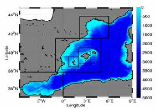
The ocean forecasting system, called WMOP, is a regional configuration of the ROMS model (Shchepetkin and McWilliams, 2005) implemented in the western part of the Mediterranean Sea from the Gibraltar Strait to the Sardinia Channel (Figure 1). The bottom topography is a 30’’ database (Smith and Sandwell, 1997). WMOP has a horizontal resolution of 2km and 32 stretched sigma levels on the vertical. The model is initialized from and nested in the larger scale Mediterranean Forecasting System (MFS, daily, 1/16º, Tonani et al., 2014) which is distributed every day by MyOcean. The atmospheric forcings coming from the Spanish Agency have a high resolution of 3h and 5km. Climatological runoffs of Var, Rhône, Aude, Hérault, Ebro and Júcar rivers are implemented in the system. They are computed from averaged daily values over the period 2009-2013 provided by the French HYDRO database and the Spanish hydrographic confederations of Ebro and Júcar rivers. A weekly model reinitialization is performed using a 3-week spinup from the MFS fields. Because data assimilation is not yet integrated in the system, this spinup avoids too much drift of the ocean model from the observed conditions but allows the WMOP system to generate (sub-)mesoscale features. The operational system runs on a daily basis and provides 3-day forecasts of ocean temperature, salinity, sea level and currents saved every 3 hours.
Figure 1 Model configuration. Colour indicates model bathymetry (in m). Boxes indicate regional zooms for data visualization.
3.2 WMOP visualization
Data visualization has been developed and is published on-line. It provides high resolution (3h, ~2km) animations and figures of the 3-day ocean forecasts over the whole western Mediterranean and in sub-regions (Figure 1): Balearic Islands region and specific zooms on Islands (Ibiza-Formentera and Mallorca-Menorca), Channels (Ibiza and Mallorca Channels), and adjacent basins (Gulf of Lion and Alboran Sea). Figure 2 illustrates the WMOP surface temperature and current around the Balearic Islands on 2 October 2014 from the ocean forecasting system.
Figure 2 WMOP ocean forecast in the Balearic Islands region on 2 October 2014 at 00:00:00.
Additionally, an interactive application (lw4nc2) has been developed at SOCIB to visualize the model outputs selecting variables (temperature, salinity, sea surface, currents, barotropic velocity) and visualization types (animations, maps, regional zooms, time series at fixed locations, and vertical sections) for past, present and forecast dates.
3.3 WMOP ocean indicators
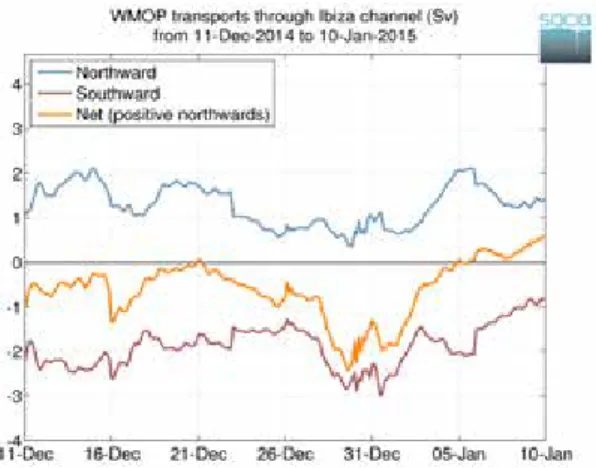
The model behaviour is monitored following the temporal evolution of ocean indicators (spatially averaged Sea Surface Temperature and Salinity, surface Kinetic Energy; Mixed Layer Depth maximum; total Heat Content within the 0-150m vertical layer) over the whole basin and in sub-regions of particular interest (Balearic Sea, Gulf of Lion, Alboran Sea). Transports in key sections (in particular, Strait of Gibraltar and Balearic Channels) are also computed. All these indicators are computed every day and the last 30-day time series are updated and published daily. They allow to systematically monitor the behaviour of the system and are very useful to detect changes in ocean properties as represented by the model. 3-hourly transports are illustrated in Figure 3 in the Ibiza Channel over the period from 11 December 2014 to 10 January 2015.
Figure 3 WMOP transport through the Ibiza Channel (Sv) from 11th December 2014 to 10th January 2015.
4. Validation procedures
Validation procedures have been developed to assess the model performance at daily, monthly and seasonal time scales. Multi-platform observations with various spatial and temporal resolution and coverage, including satellite-derived products and in situ measurements, are used. Both Near-Real-Time (NRT) and Delayed-Time (DT) model-data comparisons are being performed through statistical metrics and diagnostics. In this way, the validation is multi-variable and multi-scale (from basin to sub-basin and local scales). The ocean forecasts are assessed in terms of large-scale features, surface conditions, circulation and variability, vertical structure and water masses.
4.1 Near-Real-Time validation
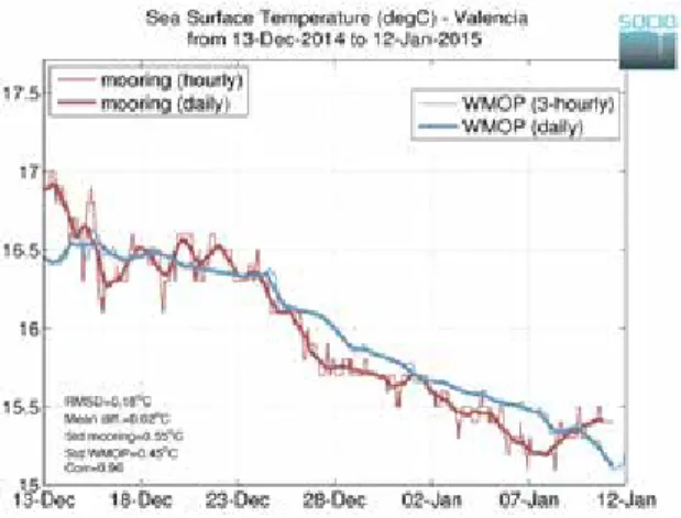
The NRT validation, which is published on-line every day, consists in comparing model outputs with available observations for the day before.
• WMOP Sea Surface Temperature compared to satellite products (CNR-ISAC, daily, 1/16º, www.myocean.eu, Buongiorno Nardelli et al., 2013)
• WMOP geostrophic currents compared to altimetry products (AVISO-CLS SSALTO/ DUACS 2014, daily, 1/8º, www.aviso.oceanobs.com)
• WMOP temperature and salinity vertical profiles compared to Argo floats (www. ifremer.fr)
• WMOP temperature, salinity and currents compared to fixed moorings along the Iberian shelf (Tarragona, Valencia, Cabo de Gata, Cabo de Palos, hourly, www.puertos. es)
The NRT validation allows monitoring of the system performance and provides updated information about the accuracy and the realism of the system. An illustration of the comparison between the observed and simulated SST at Valencia station is given in Figure 4.
Figure 4 Time series of the fixed mooring and WMOP SST at Valencia station from 13 December
2014 to 12 January 2015.
4.2 Delayed Mode validation
Additionally, a DT validation has been developed to investigate the model errors, to attempt to determine their origin and to improve the ocean forecasts. An intercomparison with the parent model (MFS) is also carried out to evaluate its impact on WMOP outputs and also to highlight the possible benefit of high resolution ocean model for operational applications. Several intercomparisons are performed at various spatial and temporal scales:
• Sub-basin scale assessment over the last year in order to detect regional biases and to improve the representation of physical processes
• Use of new technologies, such as the gliders which provide very high resolution temperature and salinity profiles. They allow monitoring and evaluating mesoscale features and water masses properties at “choke” point (e.g. Ibiza Channel).
• Operational case study: deployment of drifters, comparison of observed and simulated trajectories.
4.3 Process oriented research
The development and improvement of the ocean forecasting system is based on the scientific research carried out in the Modelling and Forecasting Facility in collaboration with other Spanish and international institutions. Numerical and scientific studies have been carried out, combining hindcast simulations and historical data, to better understand the ocean system and the model behaviour. Here are some examples:
• Development of regional circulation hindcast simulations to study western Mediterranean variability
• Sub-basin scale assessment and intercomparison of hindcast simulations in the western Mediterranean (Juza et al., 2015b)
• Mesoscale dynamics studies (Bouffard et al., 2012) • Water masses formation and propagation (Juza et al., 2013)
• Ecosystem response to oceanic conditions, bio-physical coupling (Oguz et al., 2013, 2014) as well as applications for Bluefin Tuna, jellyfishes, turtles
• Preliminary study on data assimilation including new platforms such as gliders
5. Conclusions
The high resolution WMOP forecasting system is operational, providing daily 72-hour ocean predictions, available and evaluated on-line on SOCIB website. The ocean forecasts are systematically assessed using multi-platform observations (remote sensing data and
in situ measurements) through Near-Real-Time validation procedures in order to monitor
the performance of the system. The systematic routine validation allows to detect regional and local model errors but also to show the general realism of the WMOP system in terms of large-scale surface ocean circulation and variability, as well as vertical hydrographic structure and water masses properties. The operational validation is being extended to other datasets, such as High-Frequency radar, additional fixed moorings and drifters deployed by SOCIB. The improvements of the forecasting system are being pursued through Delayed Mode and long-term comparisons at basin and sub-regional scales as well as sensitivity tests on model parameters. Data assimilation is planned to be implemented in the system, including satellite products, Argo floats, XBTs, CTDs, as well as high resolution data such as gliders and High-Frequency radar. The improvements of the forecasting system are also supported by process-oriented studies using hindcast simulations and historical data.
Acknowledgements
MyOcean Products (www.myocean.eu) from the Mediterranean Monitoring and Forecasting Centre (MED-MFC) which produces the Mediterranean Forecasting System have been used, as well as those from CNR-ISAC which provides optimally interpolated Sea Surface Temperature products. The atmospheric forcings are provided by the Spanish National Institute of Meteorology (AEMET). The altimeter products are produced by SSALTO/DUACS and distributed by AVISO. The Coriolis project (Ifremer) collects and provides the Argo floats. Finally, the data from fixed moorings along the Spanish coast are maintained and provided by Puertos del Estado.
References
Bouffard, J., Renault, L., Ruiz, S., Pascual, A., Dufau, C., and Tintoré, J. (2012). Sub-surface small-scale eddy dynamics from multi-sensor observations and modelling.
Progress in Oceanography, 106, 62-79.
Buongiorno Nardelli, B., Tronconi, C., Pisano, A., and Santoleri, R. (2013). High and Ultra-High resolution processing of satellite Sea Surface Temperature data over Southern European Seas in the framework of MyOcean project. Remote Sensing of
Environment, 129, 1-1.
Heslop, E., Ruiz, S., Allen, J., López-Jurado, J.L., Renault, L., and Tintoré, J. (2012). Autonomous underwater gliders monitoring variability at ‘’choke points’’ in our ocean system: A case study in the Western Mediterranean Sea. Geophysical Research
Letters, 39, L20604.
Juza, M., Renault, L., Ruiz, S., and Tintoré, J. (2013). Origin and pathways of Winter Intermediate Water in the North-western Mediterranean Sea using observations and numerical simulation. Journal of Geophysical Research, 118(12), 6621-6633. Juza, M., et al. (2015a). SOCIB operational ocean forecasting system and multi-platform
validation in the western Mediterranean Sea. Submitted to Journal of Operational
Oceanography, Special Issue “Proceedings of the 3rd Italian GNOO Conference on operational oceanography, innovative technologies and applications”.
Juza, M., Mourre, B., Lellouche, J.-M., Tonani, M., and Tintoré, J. (2015b). Sub-basin scale assessment and intercomparison of numerical simulations in the western Mediterranean Sea. Submitted to Journal of Marine Systems.
Lana, A., Fernandez, V., and Tintoré, J. (2015). SOCIB Continuous Observations of Ibiza Channel Using HF Radar. Sea Technology, in press.
Malanotte-Rizzoli, P., et al. (2014). Physical forcing and physical/biochemical variability of the Mediterranean Sea: a review of unresolved issues and directions for future research. Ocean Science, 10, 281-322, doi:10.5194/os-10-281-2014.
Marchesiello, P., McWilliams, J.C., and Shchepetkin, A. (2001). Open boundary conditions for long-term integration of regional oceanic models. Ocean Modelling, 3, 1-20.
Oguz, T., Macias, D., Renault, L., Ruiz, J., and Tintoré, J. (2013). Controls of plankton production by pelagic fish predation and resource availability in the Alboran and Balearic Seas. Progress in Oceanography, 112-113, 1-14, doi:10.1016/j. pocean.2013.03.001.
Oguz, T., Macias, D., García-Lafuente, J., Pascual, A., and Tintoré., J. (2014). Fueling Plankton Production by a Meandering Frontal Jet: A Case Study for the Alboran Sea (Western Mediterranean). PlosOne, 9(11): e111482. doi:10.1371/journal. pone.0111482.
Reglero, P., Alvarez-Berastegui, D., Balbin, R., López-Jurado, J.L., and Alemany, F. (2012). Geographically and environmentally driven spawning distributions of tuna species in the western Mediterranean Sea. Marine Ecology Progress Series, 463,273-284.
Robinson , A.R., Leslie, W.G., Theocharis, A., and Lascaratos A. (2001). Mediterranean Sea Circulation. Encyclopedia of Ocean Sciences, vol. 3, pp. 1689-1705, Academic, London.
Sayol, J.-M., Orfila, A., Simarro, G., López, C., Renault, L., Galán, A., and Conti, D. (2013). Sea surface transport in the Western Mediterranean Sea: A Lagrangian perspective. Journal of Geophysical Research, 118(12), 6371-6384.
Shchepetkin and McWilliams (2005). The regional oceanic modelling system (ROMS): a split explicit, free-surface, topography-following-coordinate oceanic model. Ocean
Modelling, 9, 347-404.
Smith and Sandwell (1997). Global sea floor topography from satellite altimetry and ship depth soundings. Science, 277, 1956-1962.
Tintoré, J., et al. (2013). SOCIB: The Balearic Islands coastal ocean observing and forecasting system responding to science, technology and society needs. Marine
Technology Society Journal, 47(1), 101-117.
Tonani et al. (2014). The Mediterranean Monitoring and Forecasting Centre, a component of the MyOcean system. Proceedings of the Sixth International Conference on
EuroGOOS 4-6 October 2011, Sopot, Poland. Edited by H. Dahlin, N.C. Fleming
and S. E. Petersson. First published 2014. Eurogoos Publication no. 30. ISBN 978-91-974828-9-9.
User Handbook Ssalto/Duacs: M(SLA) and M(ADT) Near-Real Time and Delayed-Time.SALP-MU-P-EA-21065-CLS, edition 4.1, May 2014.