Operational Management and Geodecisional Prototype to Track and Trace AGricultural Production
New tools
for precision livestock
management
Editorial coordination: IICA, PROCISUR Mechanical editing: IICA, PROCISUR Layout: Esteban Grille
Cover: Esteban Grille Printed: Boscana
New tools for precision livestock management / IICA, PROCISUR – Montevideo.: IICA, 2009
60 p.; 18.7x26.5 cm. ISBN 13: 978-92-9248-148-3
1. Livestock 2. Meat production 3. Productivity 4. Economic competition I. IICA II. Título
AGRIS DEWEY
E20 338.176213
This publication is also available in electronic (PDF) format in IICA’s and PROCISUR’s Web sites at http://www.procisur.org.uy , http://www.iica.int © Inter-American Institute for Cooperation on Agriculture (IICA). 2009
IICA encourages the fair use of this document. Proper citation is requested.
3
OTAG - OperATiOnAl MAnAGeMenT And GeOdecisiOnAl prOTOType TO TrAck And TrAce AGriculTurAl prOducTiOn
Presentation ... 5
Part 1 Reminder of objectives and actors ... 8
General objectives ... 8
Partners and Actors ...10
Part 2: State of the art: Traceability in Europe, Quebec and Southern Cone countries Laws, rules and regulations on traceability ...16
A. Animal welfare ...16
B. Animal identification ...17
C. Food production and traceability ...18
OTAG Quebec Research Contribution ... 20
ATQ research and assessment projects associated to OTAG (2005-2009) ... 20
Brazilian Traceability System (SISBOV) ... 23
The Argentinean Traceability System ... 26
Part 3: Data and tool requirements OTAG information system... 28
Actors ... 28
Technological platform ... 30
UML Model ... 30
Development of electronic collars to track and trace cattle ... 32
Electronic collars ... 33
Power supply management ... 35
Base station... 36
Base station software development ... 37
Towards a Spatial Decision Support System for Animal Traceability ... 38
Part 4 The OTAG Operational Prototype and its Web Management Interface ... 44
The OTAG Operational Prototype: Lessons from Experiments in France and Brazil ... 44
The Web Management Interface ... 45
User interface ... 47
Table of contents
Conclusion ... 50
References ... 50
Part 5 Dissemination and improvement ... 52
Direct and indirect impacts of OTAG ... 52
Dissemination of Results ... 53
Added value at European and International level ... 54
Interaction with other relevant research activities ... 54
ANNEX: Scientific references ... 57
Articles ... 57
Book chapters ... 57
5
OTAG - OperATiOnAl MAnAGeMenT And GeOdecisiOnAl prOTOType TO TrAck And TrAce AGriculTurAl prOducTiOn
Presentation
The OTAG Project has been the first initiative where PROCISUR has been involved bringing precision tools applied to livestock management.
The possibility of integrating PROCISUR into this research consortium with European Union Organizations brought an additional value to the existing research capability of our Partners; in particular, to achieve a better understanding of risk management issues in extensive livestock production.
For Southern Cone countries with a large stock of grazing animals, the fact of improving live-stock production track and trace, opens great opportunities, not only for studying animal be-havior in grazing management experiments, but also for monitoring animal movement in pro-duction herd with different purposes, such as setting boundaries among countries for sanitary control.
It is of interest for PROCISUR to contribute with the publication and diffusion of the results of projects like this one, in order to consolidate a new international network using this advanced technologies, and to make a new contribution to the modernization and improvement of the ef-ficiency of Agriculture.
Emilio Ruz
Executive Secretary PROCISUR
7
OTAG - OperATiOnAl MAnAGeMenT And GeOdecisiOnAl prOTOType TO TrAck And TrAce AGriculTurAl prOducTiOn
General objectives
OTAG is a Specific Support Action implemented within the 6th Framework Programme of the EU commission. It may be used to help in preparations for future Community research and tech-nological development policy activities including monitoring and assessment activities related to food safety and security.
The main objective of OTAG was to improve an Operational Agricultural Production Manage-ment and Geodecisional Prototype Platform to address the global challenges of track and trace emerging risks in beef production within the context of Southern Cone Countries, in particular Brazil and Argentina, and EU policies. The prototype was intended to be implemented and tested under control conditions in Campo Grande EMBRAPA Research Station in Brazil. To achieve this objective the following issues have been addressed:
a. Animal mobility, land use and pasture management;
b. Scale issues in the emerging risk management and disease control;
c. Promotion of operational precision geomatics tools and methods based on emerging tech-nology such as RFID, High resolution remote sensing, LBS, GIS, and DSS to favour sustain-able beef production practices and sustainsustain-able landscape structure and function;
d. Use of state of the art technologies for beef production, risk management and decision mak-ing (innovative contribution of Agri-traçabilité Québec http://www.agri-tracabilite.qc.ca ); e. Promotion of new technological and operational platform for agricultural risk
manage-ment (crisis situation, food safety and regulation, market changes, trade issues)
OTAGhas integrated current knowledge and expertise from the Consortium Members as well as existing and emerging technologies into a geodecisional prototype system. OTAG has com-menced an in-depth analysis of current practices throughout the beef production chain. Good expertise on user’s and decision maker’s expectations regarding the type of confidence they would like to see regarding food safety and quality regulations has been useful for orientating works. Results from previous industrial/socio-economic research have been taken into account with recommendations on beef production best practices, and a crisis and risk expectations analysis.
OTAG also intends to expand this work in order to cover the four geographic dimensions of
longitude, latitude, altitude and time attached to a decisional polygon. Various techniques are currently employed to acquire and manage information related to beef production. Irrespective of how this data is recorded today, a standard recording ontology had to be devised and incorpo-rated into the OTAG scheme.
Reminder of objectives and actors
9
OTAG - OperATiOnAl MAnAGeMenT And GeOdecisiOnAl prOTOType TO TrAck And TrAce AGriculTurAl prOducTiOn
Using product information as input, as well as its geographic origin, production methods and certification, movement over space and time, OTAG needed to take in account that in Brazil we do not have a cadastral system. With the absence of a cadastral system OTAG has thought about the way in which to innovate by proposing a new spatial and land management scheme of refer-ence (see current thesis, described hereafter).
Although designing a prototype was the main objective, OTAG has also thought about the fol-lowing steps, especially how to ensure that a practical, cost-effective, reliable and accurate risk management system scheme can be effectively put in place throughout a beef production chain, but can provide the means to create the necessary critical mass to ensure broad take up of the project’s results.
Specific intended objectives Measurable forecasted indicators
1. State of the art and emerging technology for Southern Cone Countries
and issues of EU regulations Online reports and technical notes 2. Put in place a practicable risk management system. Peer review
3. Put in place a practicable risk management open source
geodecisional system for extensive bovine production. Internet accessibility 4. Implement a demonstrator in Brazil Test results
5.Establish a set of workable and acceptable best practice recommendations for Southern Cone Countries for the Beef sector. Develop a better understanding of risk management issues in extensive bovine production.
Technical note Scientific reports 6. Consolidate the existing cooperation and create a new international
network of partnerships within Southern Cone Countries, EU, mainly via Alcuefood1, PETER2 projects and with Canada. Networking of national
research activities.
Number of: - scientific missions - exchange of staff members - student exchanges 7. Knowledge transfer between partners facilitated by the Internet
(efficient Website), workshops and meeting exchanges between the partners.
- 4 workshops
- 2 peer review meeting - PhD and Master students - OTAG Website
1- ALCUEFOOD -“From European fork to Latin American farm”: an innovative networking platform for EU– LAC partnerships in food quality and safety R&D. www.alcuefood.org
2- PETER -Promoting European Traceability Excellence & Research- www.eu-peter.org
Other contributions of the OTAG project, such as “specific support action”, have been achieved or are still expected:
• to promote and sustain a “tripartite” R&D approach between Europe, Southern Cone Countries and Canada,
• to encourage participation of SMEs,
Human resources have been mobilized through the relevant permanent staff of each institution. Op-portunities for complementary national funding have been sought through national R&D agencies and the private sector, with a view to improve and promulgate the prototype at the end of the project.
Partners and Actors
Partner 1: Cemagref (www.cemagref.fr) - Institut de recherche pour l’Ingénierie de
l’Agriculture et de l’Environnement
Cemagref is a public agricultural and environmental research institute whose work focuses on sus-tainable development in non-urban areas. It contributes to the conservation and acceptable man-agement of land and water systems, the growth of economic activity on a sustainable basis, and the prevention of associated risks. Besides advancing fundamental knowledge, Cemagref makes available its diagnostics and control methods, designs negotiation and management tools, develops innovative technologies and supports public and private enterprise with its skills and experience. Cemagref develops specific scientific expertise, useful in this project, in the domains of:
• Information and communication technologies (ICT), focused on (i) the interoperability of the heterogeneous information systems used by farmers and their institutional and eco-nomical partners, (ii) data exchange and communication between environmental informa-tion systems and the associated conceptual design methodologies.
• Field monitoring using “ground-based systems”, by “ad hoc” autonomous measurement systems (soil, landscape, water, …) and developing corresponding electronic devices. Some of the main Cemagref contributors have been:
Gérard
Chuzel Dominique Didelot Patrice Faure Philippe Rameau Marie Odile Monod J. Pierre Chanet Stephan Bernard François Pinet
Partner 2 : CIRAD (www.cirad.fr) - Centre de Coopération Internationale de Recherche
Agronomique pour le développement
CIRAD has many years of experience in elaborating and managing R&D projects, putting to-gether complementary and multidisciplinary competences in agriculture and production, pro-cessing and storage, distribution and marketing, to ensure the competitiveness of the whole agri-food chain, either for local and national markets or for export, thus helping LDC to face market constraints within the globalisation context. CIRAD also acts as an interface between research & academic institutes and the private sector in order to ensure better partnerships and integration of all stakeholder concerns. Food Quality and Safety is currently a high priority research topic for CIRAD through various projects dealing either with the global food quality management and risk analysis or traceability and labelling.
11
OTAG - OperATiOnAl MAnAGeMenT And GeOdecisiOnAl prOTOType TO TrAck And TrAce AGriculTurAl prOducTiOn
Guy Henry Valery Gond Fanny Lange Caroline Blaché
CIRAD has out-posted permanent scientists in Brazil for the launching and follow-up of the activities of Cirad and its partners in the Mercosur region. They have catalysing collaborations between France, the EU and the Southern Cone, through R&D projects, technical information exchange, training courses, seminars, expertise, scientific exchanges, etc, in the same topics that are addressed by this project:
Some of the main Cirad contributors have been:
Partner 3 : EMBRAPA (www.embrapa.br) - Empresa Brasileira de Pesquisa Agropecuária
The Brazilian Agricultural Research Corporation (Embrapa) has 37 research centers, three ser-vice units, and 11 central units, in almost all Brazilian states and in different ecological condi-tions. Three Embrapa centers have important roles in the implementation of this SSA:
Embrapa Satellite Monitoring (www.cnpm.embrapa.br) focuses on research, development, and in-novation to monitor land use/land cover changes and their impacts, using orbital systems and geo-technologies that support the sustainable development of the Brazilian rural spaces and agribusiness. Embrapa Informatics’ (www.cnptia.embrapa.br) mission is to generate, adapt, and transfer knowledge, technology and bioinformatics for the sustainable development of agribusiness in Brazil. It has been engaged for more than 10 years in the development of Web-based information systems, using a myriad of programming languages (CGI, Java, Perl, PHP, C, C++, JavaScript) and Databases (MySQL, PostgreSQL, Oracle).
Embrapa Beef Cattle (www.cnpgc.embrapa.br )., located in Campo Grande, Mato Grosso do Sul, has the mission of promoting competitiveness in the bovine beef chain on a sustainable basis. Its objective is to provide solutions for the increase of production and productivity, its priority being the quality of products and sub products, health, nutrition, life quality, and social equity. Some of the main Embrapa contributors have been:
Partner 4 : Laval University and GAAP - (www.gaap.ulaval.ca)
Mateus
Batistella AndersonSoares MarcosVisoli Pedro PauloPires Thais BassoAmaral SoniaTernes
The main mission of GAAP (www.gaap.ulaval.ca) laboratory is to ensure the development of geomatics in different applied sectors. GAAP research activities and issues focus on the prob-lems associated to geospatial data acquisition, treatment and diffusion. Objectives are to insure
a better use, adaptation, improvement and understanding of spatial referenced technologies as well as GPS, satellite and airborne remote sensing, image processing, GIS, optical sensors, Lidar, fluorescence, geotechnics and precision farming sensors.
GAAP has also the mandate to support the training and research program for Highly Qualified
Personnel and promote the transfer of research results to industries and users.
The main mission of GAAP (www.gaap.ulaval.ca) laboratory is to ensure the development of geomatics in different applied sectors. GAAP research activities and issues focus on the problems associated to geospatial data acquisition, treat-ment and diffusion, territorial governance and decision making.
Objectives are to insure a better use, adaptation, improvement and understanding of spatial referenced data across the decisional making process to support a sustainable develop-ment of the natural resources as well as good territorial governance practices.
The research program of Dr. Viau’s Laboratory is divided into five major topics: Agrifood trace-ability - agrometeorology - geomatic sciences, mainly linked to airborne and satellite remote sensing - precision geomatics, precision farming, - tropical geomatics and territorial governance.
Partner 5: PROCISUR (www.procisur.org) - Programa Cooperativo para el Desarrollo
Tecnológico Agroalimentario y Agroindustrial del Cono Sur
The Cooperative Program for Technological Development in Agrifood and Agroindustry in the Southern Cone (PROCISUR) aims at developing a common effort of the National Institutes for Agricultural Research (INIAs) of Argentina, Bolivia, Brazil, Chile, Paraguay, Uruguay and IICA (Inter-American Institute for Agricultural Cooperation) to promote the cooperation among all the actors involved in agro-technological innovation in the region.
The goal of PROCISUR is to contribute to the building of a regional system of technological in-novation, striving to provide knowledge and technology to cover the demand of the Agri-food and Agro-industrial System (AAS). PROCISUR participates in OTAG diffusion plans.
Some of the main Procisur contributors have been:
Alain Viau
Third Parties: Euro-Canadian Consortium
In order to complete the partnership, a Euro-Canadian Consortium has been established. Four bodies compose this industrial consortium and will support the OTAG project.
Agri-Traçabilité-Québec or ATQ (www.agri-tracabilite.qc.ca) aims at making a significant
contribu-tion to improve food safety through the development, implementacontribu-tion and operacontribu-tion of a permanent identification and tracing system for agricultural products, both for animal and crop productions.
13
OTAG - OperATiOnAl MAnAGeMenT And GeOdecisiOnAl prOTOType TO TrAck And TrAce AGriculTurAl prOducTiOn
Financière Agricole du Quebec (FADQ) is the agency in Québec responsible for managing
fi-nancial tools for agricultural needs. Its mission is to support and encourage the development of the agricultural and agri-food sector within a perspective of sustainable development. For instance, FADQ has introduced a new way to measure insured fields, that is, by way of aerial photographs and new information technologies, as well as geomatics.
Syscan International Inc. (www.syscan.com ) is a unique chain solution supplier delivering
in-tegrated real time tracking and tracing solutions that improve business efficiency through radio frequency identification (RFID).
Allflex, (www.allflex.com.br; www.allflex-europe.com; www.allflex.com.au; www.allflex.co.uk )
is the Global Leader in Livestock Identification and Bovine Traceability solutions. Allflex has sites in UK, Australia, New Zealand, USA, China, Brazil and France, with distribution offices worldwide. The philosophy embraces innovation - providing customers a clear advantage today and in the future. Its innovations include the Allflex Global Tag with guaranteed permanent Laser-Ink Marking, Electronic (Radio Frequency) Identification Systems, Custom Laser-Marked Visual Identification Tag, Allflex Ultra Tag with high retention, Allflex range of electronic Sheep Tags, Electronic Identification Systems (based on Radio Frequency technology, ISO 11784/11785 standards), Permanently fixed and Handheld Data Collection devices.
WP1 Coordination
Cemagref
WP2 State of the art
U. Laval WP4
Geodecisional System WP3
Data and tools requirements
Cemagref
WP5 Dissemination Embrapa
Reminder of the work structure
Main objectives and results of WP1 - Coordination:
• To provide the administrative and financial management of the whole project.
• To provide strong management and monitoring of all the work undertaken during the project.
Main objectives and results of WP2 - State of the art and technology watch
• To identify opportunities and research gaps related to geodecisional tools used to manage risk and crisis events in beef production within the context of Southern Cone Countries and EU policies.
• Run an accurate State of the Art in different Countries, collecting relevant information from any concerned field (regulation, research, standard, technology, …).
Main objectives and results of WP3 - Data and tools requirements
• To identify the best practices requirements to track and trace emerging risks in beef pro-duction specifications in Southern Cone Countries and to rank priorities for suitable geo-decisional systems.
• To define the requirements for data collection, integration, architecture and system in-teroperability.
• To adapt existing operational tools for OTAG System and to design the protocols and proof of concept of OTAG System.
Main objectives and results of WP4 - Operational geodecisional prototype
• To design and implement the operational geodecisional prototype system:
• To set-up procedures and outlines, define the methodology and tools for the prototype, ensuring that it will be operational (under control condition – Campo-Grande).
• To set-up the demonstrator for the case study.
• To assess the technical specifications for the information system structure and function (architecture, analysis and processing functions, data integration…).
• To design this information system and its use possibilities.
Main objectives and results of WP5 - Dissemination and improvement of the OTAG Concept
• To broadcast results of the project, its ongoing work and outputs.
• To manage a broadcast plan (including meetings and workshops), publications and diffu-sion on the Website, communication to the public and private sector, the scientific com-munity, …
State of the art:
Traceability in Europe,
Quebec and Southern
Cone countries
Laws, rules and regulations on traceability
Writing coordinated by Fanny Lange, CIRAD
A. Animal welfare
The Treaty of Amsterdam, in force since May 1st, 1999 lays out new ground rules for the actions of the European Union (EU) on animal welfare in a special “Protocol on the Protection and Welfare of Animals”. It recognises that animals are sentient beings and obliges European Institutions to pay full attention to the welfare requirements of animals when formulating and implementing Community legislation. The protocol establishes the responsibility of the EU to legislate with an aim to improve the welfare of animals and prevent cruelty against and mistreating of animals in areas covered by the Treaty (such as agriculture).
“The new Treaty establishing a Constitution for Europe, signed on October 29th, 2004 by the Heads of State or Government of the 25 Member States and the 3 acceding and candidate coun-tries, also sets forth the commitment to ensure the protection of animals. Article III 121 pro-vides that the Union and Member States shall fully consider the requirements of animal welfare in formulating and implementing the Union’s agriculture, fisheries, transport, internal market, research and technological development and space policies. This will be done while respecting the legislative or administrative provisions and customs of Member States particularly related to religious rites, cultural traditions and religious heritage.”
Animal welfare on the farm
In 1998, Council Directive 98/58/EC on the protection of animals kept for farming purposes issued general rules for the protection of animals of all species kept for the production of food, wool, skin or fur or for other farming purposes, including fish, reptiles or amphibians. These rules are based on the European Convention for the Protection of Animals kept for Farming Purposes. They reflect the so-called ‘Five Freedoms’ as adopted by the Farm Animal Welfare Council:
• Freedom from hunger and thirst - access to fresh water and a diet for full health and vigour, • Freedom from discomfort - an appropriate environment with shelter and comfortable rest area, • Freedom from pain, injury and disease - prevention or rapid treatment,
• Freedom to express normal behaviour - adequate space and facilities, company of the ani-mal’s own kind,
17
OTAG - OperATiOnAl MAnAGeMenT And GeOdecisiOnAl prOTOType TO TrAck And TrAce AGriculTurAl prOducTiOn
Community legislation concerning the welfare conditions of farm animals lays down minimum standards. National governments may adopt more stringent rules provided they are compatible with the provisions of the Treaty.
Animal welfare during transport
The European Commission welcomes the adoption by the Council on November 22nd, 2004 of a Regulation on the protection of animals during transport, which will help to safeguard animal welfare by radically improving the enforcement of animal transport rules in the EU. The Regula-tion amounts to a radical overhaul of the existing EU rules on animal transport and it identifies the chain of all those involved in animal transport, defining “who is responsible for what” thus facilitating more effective enforcement of the new rules. The Regulation introduces new and more efficient monitoring tools such as checks on vehicles via a satellite navigation system as of 2007. It also introduces much stricter rules for journeys of more than 8 hours, including a sub-stantial upgrading of vehicle standards.
According to Regulation (EC) No. 1/2005 on the protection of animals during transport and related operations, satellite navigation systems will become obligatory in road vehicles transport-ing livestock over 8 hours. For newly built vehicles, it will become obligatory as of January 2007 and for all vehicles as of January 2009.
Animal welfare at slaughter
EU legislation on slaughtering practices aims to minimize the pain and suffering of animals through the use of properly approved stunning and killing methods, based on scientific knowl-edge and practical experience. The first Council Directive 74/577/EC on stunning animals before slaughter was replaced in 1993 by Council Directive 93/119/EEC covering a wider range of ani-mals and slaughter circumstances.
B. Animal identification
The basic objectives for Community rules on the identification of bovine animals are
• the localisation and tracing of animals for veterinary purposes, which is of crucial impor-tance for the control of infectious diseases,
• the traceability of beef for public health reasons,
• the management and supervision of livestock premiums as part of the common organisa-tion of the market in beef and veal.
The system for the identification and registration of individual bovine animals includes the fol-lowing elements:
• double ear tags for each animal, with an individual number • maintaining a register on each holding (farm, market etc.) • cattle-passports
• a computerized database at national level
The models of ear tags, passports and holding registers, which are used in the different Member States, can be found at:
http://ec.europa.eu/food/animal/identification/bovine/id_bovine_animals_en.htm
C. Food production and traceability
For consumers, safety is the most important ingredient of their food. Recent crises have under-mined public confidence in the capacity of the food industry and of public authorities to ensure that food is safe. The European Commission has identified food safety as one of its top priorities. The White Paper on Food Safety of January 12, 2000 sets out the plans for a proactive new food policy: modernizing legislation into a coherent and transparent set of rules, reinforcing controls from the farm to the table and increasing the capability of the scientific advice system, so as to guarantee a high level of human health and consumer protection.
The Strategic Priorities of the White Paper are: • to create a European Food Safety Authority
• to consistently implement a farm-to-table approach in food legislation
• to establish the principle that feed and food operators have primary responsibility for food safety; that Member States need to ensure surveillance and control of these operators; that the Commission shall test the performance of Member States’ control capacities and capa-bilities through audits and inspections
On January 28th, 2002 the European Parliament and the Council adopted Regulation (EC)178/2002 laying down the General Principles and requirements of Food Law. The aim of the General Food Law Regulation is to provide a framework to ensure a coherent approach in the development of food legislation. At the same time, it provides the general framework for those areas not covered by specific harmonized rules but where the functioning of the Internal Market is ensured by mu-tual recognition. It lays down definitions, principles and obligations covering all stages of food/ feed production and distribution.
The General Principles of Food Law (Articles 5 to 10) entered into force on 21 February 2002 and must be followed when measures are taken. Existing food law principles and procedures must be adapted by January 1st, 2007 in order to comply with the general framework established by Regulation EC/178/2002.
The food law aims at ensuring a high level of protection of human life and health, taking into account the protection of animal health and welfare, plant health and the environment. This
19
OTAG - OperATiOnAl MAnAGeMenT And GeOdecisiOnAl prOTOType TO TrAck And TrAce AGriculTurAl prOducTiOn
integrated “farm to fork” approach is now considered a general principle for EU food safety policy. Food law, both at national and EU level, establishes the rights of consumers to safe food and to accurate and honest information. The EU food law aims at harmonizing existing national requirements in order to ensure the free circulation of food and feed in the EU. The food law rec-ognizes the EU’s commitment to its international obligations and will be developed and adapted considering international standards, except where this might undermine the high level of con-sumer protection pursued by the EU.
To complete this section it is important to read state of the art reports produced for OTAG pre-senting the situation for France and Quebec as well as for Brazil (These study reports are avail-able on the OTAG public WEB site (http://www.otag-project.org/ ).
OTAG Quebec Research Contribution
1Dr Alain A. Viau, Laval University
The expertise of the Laboratory GAAP at Laval University was focused on Applied and Agricul-tural Geomatics. It started its research activities related to Traceability issues in 1998. An important research work carried out was one on the development of the GeoTraceability (GTA) concept: http://www.geotraceagri.net/doc/GeoTraceAgri_Finalreport_EN.pdf
A good traceability system for agri-food products must include user/partner identification, premises identification, product identification and movement follow-up.
Traceability is currently a very hot topic. It is the “aptitude to find the history, the use or the local-ization of an entity by means of recorded identifications” (ISO8402). In other words, traceability is the creation of a tracking system (http://www.can-trace.org / LEARNMORE/ FAQ/tabid/98/ language/en-US/Default.aspx; http://www.agri-tracabilite.qc.ca ), for all stages of production, from the origin of the product to the end product, which can be used as a benchmark to ensure the origin and quality of the product in order to guarantee that it is safe for consumer consump-tion. Consumers are more and more concerned about the quality and safety of the food they buy, as it has been clearly demonstrated during the recent crisis that affected the agri-food industry (http://www.agri-tracabilite.qc.ca/documents/cfm-feb08.pdf).
The EU food legislation (payments 178/2002, 852/2004, 183/2005, 853/2005) has played an im-portant role by redefining obligations of traceability on the whole agri-food chain, not only in European Country but also worldwide.
ATQ research and assessment projects associated to OTAG (2005-2009)
The following section presents the synthesis of Agri-Traçabilité Quebec’s contribution (cf. “ATQ Annual Report” - http://www.agri-tracabilite.qc.ca/ ). ATQ developed a service offer that not only is interesting for potential customers but is also adaptable to various needs, whether a com-plete traceability system is required, a software license or personalised services. Furthermore, a new independent organisation is being set up, Agri-Traçabilité International (ATI - http://www. traceability.ca/index.html ), whose mandate is to promote Quebec expertise in terms of perma-nent identification and traceability.
1 The following content is a textual transcription from the ATQ activities reports, FADQ reports as well as re-search studies reports related to OTAG rere-search activities (http://www.agri-tracabilite.qc.ca/en/publications-atq-others.html - http://www.fadq.qc.ca/index.php?id=914&L=1 - http://www4.agr.gc.ca/AAFC-AAC/display-afficher. do?id=1244051104062&lang=eng). The content of this summary integer ATQ and FADQ contributions and present the state of the art in traceability for Quebec.
21
OTAG - OperATiOnAl MAnAGeMenT And GeOdecisiOnAl prOTOType TO TrAck And TrAce AGriculTurAl prOducTiOn
ATQ was established to develop, implant and maintain an information system allowing to: a. Limit and rapidly eliminate potential crises by reacting quickly to problems related to
ani-mal disease and food safety;
b. Retrace all identified animals to their herd of origin and know their histories, their move-ments, and their present locations;
c. Improve diagnostic and checking capabilities thus reducing the risks associated with the export and import of livestock;
d. Regroup production activities occurring at the same place in a single database to achieve traceability from the farm to the table for all types of agricultural productions;
e. Negotiate partnerships for information exchange between stakeholders in the agrifood sec-tor;
f. Standardise applications between the different regulated agricultural productions.
1- FDX tag assessment
Some FDX tags, approved by CCIA, offer an alternative to HDX tags for the beef and the dairy industries. Reading tests will be conducted at strategic key premises with live animals, as well as resistance tests (ageing and breaking strength), held in CRIQ laboratory.
2- Bovine Tag Retention : Long Term Assessment
In cooperation with the Allflex Company, a rigorous follow-up project has been undertaken. Vis-its will be made once or twice a year to about 20 beef and dairy farms. The project will provide a statistical analysis of the on-farm rate of ear tag loss. Also, a neutral body will perform laboratory tests on the resistance of the tag materials.
3-Live Animal Transport
The goal of this project is to develop turnkey solutions adapted for the livestock transporta-tion sector, that will allow for the automated collectransporta-tion and transfer into the ATQ database of traceability-related information. The Solutions for Transport Traceability is comprised of RFID readers, pocket computers with the TransTraq software installed, and portable printers.
4- Live Animal Transport - Information transfer section
The project is aimed at the transfer of information using the Solutions for Transport Traceability at strategic points (auctions and abattoirs) following the transportation and unloading of live-stock (beef, sheep, pork). Project partially funded by Agriculture and AgriFood Canada through the Canadian Integrated Traceability Program.
5- Live Animal Transport - Lots section
ani-mals with an individual identification (beef and sheep) to the practicalities of identification by lot (pork, poultry). Project partially funded by Agriculture and AgriFood Canada through the Canadian Integrated Traceability Program.
6- Evaluation of equipment functionality
Producers through field trials of a hand-held electronic system and a targeted information cam-paign aim this project at improving automated equipment for the collection and transfer of traceability information and its uptake. Project partially funded by Agriculture and AgriFood Canada through the Canadian Integrated Traceability Program.
7- Table Eggs Traceability
Project objectives are to set up a single identification and traceability system for light breed bird lots in Quebec’s table eggs industry as well as to provide a single identification system from the farm to the table for the eggs produced, graded and marketed by the producers enrolled in the quality assurance program.
8- Sheep RFID tags comparison
Two years after the implantation of the traceability system in the sheep sector, sheep and lamb producers have judged it pertinent to try new identifiers. In January 2006, a pilot project was begun to evaluate two new types of identifying tags.
9- Bovine Tag Retention: Loose Housing
Following the comprehensive identification of beef livestock, a certain number of on-farm veri-fications were done, as a follow-up to the pilot project done in 2003. A second pilot project was undertaken, this time looking at ear tag retention in loose housing conditions (6 dairy farms and 2 beef farms). Results: 84.95 % of the 831 dropped tags originate from the comprehensive identification operation.
10- RFID and Cervidae traceability
The pilot project on cervidae permanent identification and traceability ended in December 2005. More than 5300 animals have been identified in the premises of 14 wapiti breeders, 12 red deer breeders, and 2 white-tailed deer breeders.
11- Bovine Tags Retention : Stall Housing
Willing to continue improving the existing system, Agri-Traçabilité Québec, with the participa-tion of the PATLQ, the Quebec Artificial Breeding Centre, Holstein Canada and the tags pro-vider, has set up a tag retention committee.
23
OTAG - OperATiOnAl MAnAGeMenT And GeOdecisiOnAl prOTOType TO TrAck And TrAce AGriculTurAl prOducTiOn
Brazilian Traceability System (SISBOV)
2Dr. Pedro Paulo Pires and Thaís Basso Amaral, Embrapa
Brazil counts, since January 2002, with a tracking system for bovines called System of Identifi-cation and CertifiIdentifi-cation of Origin for Bovines and Buffaloes (SISBOV). This traceability system consists of a set of norms and procedures defined by the Ministry of Agriculture, Livestock and Supply (MAPA) with the purpose of identifying, registering and monitoring, individually, all bovines and buffaloes born in Brazil, or imported, so as to determine their origin, production and productivity of livestock, their sanitary status, and the security of animal by-products. SISBOV was instituted by the Normative Instruction 1, of January 9th, 2002 and regulated by the Normative Instruction 23 of the Animal Defense Secretary of MAPA, dated February 2002. Since April 6th, 2004, SIBOV has been regulated by new operational norms and procedures of animal traceability and identification. Changes were determined by Normative Instruction 21 to facilitate operation, standardise the identification seal, help fight eliminating diseases, increase participation of states and keep track of animals from the age of 40 days onwards. At last, the final text of Normative Instruction 17, published on July 14th, 2006, established a new different structure.
Enrollment in the new system is voluntary; however it continues to be mandatory for commer-cialisation in markets requiring traceability. With Normative Instruction 17, the Rural Establish-ment Approved by SISBOV (ERAS) emerges, establishing the following main requireEstablish-ments:
• Registration of producer • Registration of property • Basic Production Protocol • Terms of enrollment in SISBOV
• Registration of raw materials used in the premises
• Individual identification of 100% of bovines and buffaloes within the property • Animal movement traceability
• Supervision of the Certifying Body licensed by the Ministry of Agriculture, Livestock and Supply (MAPA)
• Periodic inspections by the Certifying Body
2 http://www.agricultura.gov.br/pls/portal/docs/PAGE/MAPA/MENU_LATERAL/AGRICULTURA_PECUA-RIA/SISTEMAS_INFORMATIZADOS/SISBOV_NOVO/IN17.PDF
According to the new rules, it will be mandatory for all bovines and buffaloes in rural premises approved by SISBOV to be individually identified and registered in the SISBOV database, includ-ing raw materials used in the premises durinclud-ing the production process.
It is a major progress considering that from 2009 onwards only bovines and buffaloes will be to enter approved rural premises provided they originate at premises also operating under the same SISBOV regulations. The system will allow information to be updated by Agencies Executors of the Animal Health in the states and by the Certifying Agency of the Rural Establishment ap-proved by SISBOV, certified by MAPA.
Use of technological tools
According to the new regulations, the seal on the ear device has a new format. It shows the SISBOV watermark, it is printed with the standard official seal, and has a new 15- digit code. The former code had 17 digits which could also identify the originating micro region of the animal. The new seal iden-tifies the originating country of the animal (3 digits) and the originating state (2 digits) in addition to a set of nine digits for the bovine or bufallo’s identification and a one-digit identification code. According to requirements established by MAPA, when an animal is certified by SISBOV, it re-ceives a document called “Certificate of Origin” or “Document of Animal Identification” (DIA), and a device with the SISBOV number showing the origin of the bovine individually registered on the database. The certificate accompanies the animal all its life, from birth to slaughter, natu-ral or accidental death, and keeps track of every movement of the animal resulting from transfers or emergency sacrifice. The DIA must indicate that the animal originates from a legally estab-lished rural property and that it is registered on the SISBOV-MAPA national database.
In order for the SISBOV Certificate to be authorised, the producer must provide evidence stating that the system of production, sanitary programs and characteristics of the rural property are in accordance with the specifications defined by SISBOV regulations and requirements.
One advantage of the new system is the resistance of the identifying device, which the animal bears all its life. The new regulations are also aimed at creating dual identification, chosen from the following four options:
• an auricular device on the right ear and a button (2.6 to 3 cm long) on the left ear, with a 6 digit SISBOV identification number (from the 9th to the 14th SISBOV number);
• an auricular device on the right ear and an electronic device;
• an auricular device on the right ear and a tattoo on the left ear with a SISBOV identification number;
• an auricular device on the right ear and a SISBOV identification number marked with hot iron on the right leg. The six-digit identification number must be marked in two sets of three digits, the first set being placed on an imaginary line and the other set right below. The dual animal identification, created with the mandatory use of the right ear device and a chosen identification mode, in addition to the information registered on the database, allow for the auditing of the system.
25
OTAG - OperATiOnAl MAnAGeMenT And GeOdecisiOnAl prOTOType TO TrAck And TrAce AGriculTurAl prOducTiOn
Application of the Normative Instruction
The Normative Instruction is applicable nation-wide to rural cattle breeding premises, packing plants producing bone products, by-products and residues of high economic value, and certify-ing companies accredited by MAPA.
State and private control mechanism
SISBOV operational control is made through an official National Database. This database con-tains updated information on animals, rural and agro industrial properties; all of them are iden-tified and registered on SISBOV by accredited entities.
The monitoring of premises is the responsibility of the certifying agencies that define the com-puterised system of registration maintained by the establishments. The role of the certifying agencies consists of:
• Circulation registration and control, and management of reproduction, nutrition and sani-tary issues (vaccine, tests and treatments) of livestock.
• Registration of the inflow, outflow and use of basic materials at the premises.
• Animal identification by the Animal Identification Document (DIA). It is mandatory that all bovines and buffaloes born in identified herds are included in the program.
Re-identification
In case the identification gets lost, the Certifying Entity is able to proceed with the requested re-identification keeping records of the sequence of events.
The Argentinean Traceability System
3Fanny Lange, Cirad
In Argentina, since the year 2003, a system of individual animal identification and management was adopted and used for traceability. This system will reinforce group identification thanks to tattoos already used for cattle. The system was developed with the objective of complying with European Union demands, considering the importance of that market and its significance in its contribution to the value chain. We understand that traceability is a tool that, by means of suit-able cattle identification, contributes to the improvement of information on stock and to a use-ful knowledge of the dynamics of national livestock, allowing to improve the national sanitary system as well as to control commercial aspects. Although the individual identification system was conceived for cattle intended to be exported, it has been decided to expand the system to the whole national herd, from the individualisation of new-born calves -which will progressively be incorporated as of the year 2007, until full replacement and identification.
Animal identification is unique, not re-usable, and the animal bears it from the first movement to the last. Identification is done by means of an inviolable “button-button”-type ear tag and a unique alphanumeric 9-digit code.
3 PROCISUR, Instituto Interamericano de Cooperación para la Agricultura. Estado actual de los sistemas de tra-zabilidad para bovinos de carne em los países del Cono Sur. 2nda edición, Montevideo, Uruguay, Noviembre 2006.
Data and
tool requirements
OTAG information system
M. Visoli, S. Ternes – Embrapa; J.P. Chanet, F. Pinet, S. Bernard G. De Souza, A. Miralles – Cemagref
Information flow
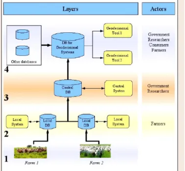
The computational architecture proposed for the OTAG prototype is organized in four layers (see Fig-ure 1). Layer 1 involves the collec-tion of data from electronic devices in the paddock. Animals have a collar with a GPS device and the paddock has sensors for the auto-matic collection of weight and vac-cination registers, and temperature measurements for each animal, among others. The information produced for the electronic devices is sent to a computer located in the farm headquarters. For this task, we intend to use the open standard XML, making it possible to use electronic devices of any manufac-turers. In fact, the definition and improvement of a standard that can be used by any manufacturer is one of the challenges posed by the OTAG Project. Layer 2 is
respon-sible for storing data which is sent by the electronic devices and associated with farm management data. The user interface of this layer will allow the farmer to manage data and draw out reports on his cattle production on the Internet. The data of each farm will be sent to Layer 3 using web-service technology. On Layer 3 the information of all the farms of the OTAG system is combined on the same database. Thus, information related to animal movements within the farm and between farms can be analysed through the use of techniques to manage geo-referenced information. The last layer is responsible of managing the data from the OTAG database and from external databases (soil, pastures, climate), and combine it in a specific database to allow geo-decisional analyses.
Actors
OTAG system actors will be responsible for the input of data and they will also get information from the system in order to make decisions regarding farm production. This information may be accessed according to each actor’s profile. The possible actors are described herein below.
Figure 1: Computational architecture of the OTAG prototype
29
OTAG - OperATiOnAl MAnAGeMenT And GeOdecisiOnAl prOTOType TO TrAck And TrAce AGriculTurAl prOducTiOn
Government
Data on animal circulation can generate information useful for decision making to be applied in simulations of real life, such as:
1. in case of an outbreak of foot-and-mouth disease, to identify the location of all the animals that had contact with an infected animal during a certain period of time before outbreak identification. This procedure allows to better invest human resources, in order to control and create a blocked area around the potential focus;
2. through the identification of a large amount of movement of animals from a specific geo-graphical point, it is possible to implement actions to minimize movements or increase control of movements in that region;
3. identification of proper sites to implant new processing units, reducing animal movement between regions and, as a consequence, minimizing the risk of contamination in case of disease.
Consumers
Consumers represent external and domestic bovine meat markets. The OTAG system can pro-vide information to those actors on production system practices and animal lives, origin, sex, feeding type, etc. This data contributes to increase product quality and reliability.
Researchers
Researchers are able to get plenty of information from the OTAG system, for different objectives such as:
1. compare results of the different production systems being used in the farms;
2. based on the data that will be integrated, such as on soil, pastures and climate, it is possible to cross data from those databases to extract new information about the real impact of these factors on the beef cattle production systems;
3. analyse in a more realistic way the relation between animal movements and occurrence of diseases.
Farmers
Farmers are the most important actors in the OTAG system. The quality of the information they supply directly depends on the benefits they may obtain from the use of the OTAG system, as well on the electronic devices implanted in theirs farms. Farmers may obtain information to:
1. obtain a better control of their animal production, being able to implant traceability of production processes;
2. receive comparative information about their production system in relation to other farms using similar systems;
3. receive news about possible outbreaks in certain regions, in order to avoid trading with animals from these regions.
Technological platform
The technological framework to be used in the development of the local system is: Java 2 En-terprise Edition Platform, IDE Eclipse, PostgreSQL and PostGIS as database systems with geo-graphical support, Hibernate tool as the persistence layer, Java Server Faces for interface design and control, Apache web server and Jakarta Tomcat application server.
During the construction of the OTAG system the need of new tools will be identified, mainly related to geo-decision. The use of multi-platform and open-source software is an essential con-dition for the OTAG project. The open source allows to study and adapt the software for specific project needs. Moreover, it allows for the technological autonomy of the partners to the project. Multi-platform is an essential requirement not only because partner institutions have distinct operational system platforms, but also because it makes it possible to implement the OTAG sys-tem in other interested institutions and distinct actors.
The use of tools for receiving, treating and organizing a great amount of data is also necessary to obtain an acceptable response time for the reports and queries demanded by final users. With this aim, we intend to analyse the use of business intelligence tools and also Spatial OLAP tech-nology. The possibility of integration with external databases is also foreseen. This can contribute to a better analysis for decision making regarding farm production. For instance, the integration of the OTAG prototype with databases on soil, pastures and climate can increase the quality of the information concerning beef cattle production.
UML Model
The model that describes the data of the OTAG local system has been formalized with the Uni-fied Modelling Language (UML). We advocate the use of UML in the model of the OTAG Sys-tem. We consider this type of formal representation as the best means to precisely describe the data managed by the OTAG local system. The model has been built interactively upon different meetings and discussions held between the various researchers involved in the project.
UML is issued from the unification of several formal object-oriented methods existing during the 90s. It is now considered as a standard for modelling computational systems. More precisely, UML is a graphical language for visualizing, specifying and constructing any parts of computer-based components. It is used successfully in information system and object-oriented develop-ments. At present, UML is the common way to represent information systems.
In the proposed class diagram describing the OTAG model, each concept is represented by a class. The main class’ attributes have been specified on the diagram. Hierarchies are used to model the nomenclatures of concepts; they are represented in UML using the generalisation/ specialisation relationship. This gives more flexibility to the model, providing the possibility of adding more precisions about concepts later.
OTAG local system is based on some concepts like farm, framer, cattle exploration, paddock, animal, sanitary event and geo-position. These concepts come from some practices of Brazilian beef cattle production systems.
The farm is an agricultural establishment that belongs to one owner. On it there must be some cattle explorations, each one under the responsibility of a farmer that can be the owner or a
lease-31
OTAG - OperATiOnAl MAnAGeMenT And GeOdecisiOnAl prOTOType TO TrAck And TrAce AGriculTurAl prOducTiOn
holder. Each cattle exploration corresponds to a physical area, with one specific production sys-tem, that can be changed periodically. Cattle exploration is divided into paddocks where animals of one determined type are raised. The paddock is characterised by a feeding system that can be modified throughout time. There is a batch of animals per paddock. A batch can be moved from one paddock to another. The animals periodically receive some vaccines (sanitary aspect), they undergo different types of handling, where weight, temperature, etc. can be measured. Moreover, each animal is subject to the occurrence of certain events such as birth, death, entrance to and exit from the farm. Animal geo-localisation (positioning) will be measured periodically, through the use of a collar on each animal, considering the ‘master/slave’ concept. The animal wearing the master collar will capture periodically, during a specific handling operation, the identification of the slave collars of all the animals around it. Then the master collar will send a UHF signal to a receiving base such as: the localisation measured by the GPS on the master collar, the list of animals around it and information about the handling operation. The receiving base will send this data by WiFi to a computer at the farm headquarters.
Based on the general foregoing description, the UML model of the OTAG local system was de-veloped using Objecteering Software, which automatically generates the model’s documentation in HTML format. We present below a general description of the packages and classes. Associa-tions between packages are presented in Figure 1. Figure 3 also presents the details of the animal package.
Development of electronic collars
to track and trace cattle
4One of the objectives of the OTAG project is to track the circulation of animals in natural and extended environments. This objective implies the availability of adapted technologies in order to estimate the positions of animals (considering a desired precision and acquisition period), and to store and make this information available to the operational geo-decisional system.
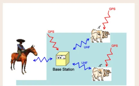
In order to reach this objective, an initial strategy was described in the OTAG project proposal. This initial so-called ‘master-slave’ approach, defines sub-groups within the herd, associated with a reference animal (the ‘master’, equipped with a GPS-based collar). A decisional polygon is defined around each ‘master’, and all the other animals located inside this polygon are con-sidered as ‘slaves’. The master identifies the slaves through the use of a communication system.
Mainly due to problems related to communication aspects, we have selected and developed a second strategy called “individual-based” approach: all animals are equipped with a GPS-based collar, which measures the position of the animal with a predefined frequency. The GPS positions are periodically transferred to a base station in order to be collected and used by the management system. Electronic collars and base stations are presented in Figure 2.
Two different elements (hardware and software) have been developed for the OTAG project to track and trace cattle:
4 P. Faure, P. Rameau, M. O. Monod, L. Moiroux– Cemagref
33
OTAG - OperATiOnAl MAnAGeMenT And GeOdecisiOnAl prOTOType TO TrAck And TrAce AGriculTurAl prOducTiOn
• Electronic collars - A collar is placed on every animal, which uses an internal GPS to mea-sure its position through a predefined frequency. Then the GPS data is transferred to a base station
• Base Station - The base station is the second developed element. The role of the base station is to collect the GPS data from all collars and make them available to an operator.
These two elements communicate with a UHF communication system and use a dedicated com-munication protocol.
Electronic collars
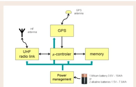
Figure 3 presents the general architecture of electronic collars.
The main elements of this device are:
• GPS and its antenna to measure the position of the animal • UHF system to communicate with the base station
• a memory to store GPS data before it is transferred to the base station • a micro-controller which manages the overall functioning of the collar
• the last element is the management of the power supply in order to have the lowest possible power consumption
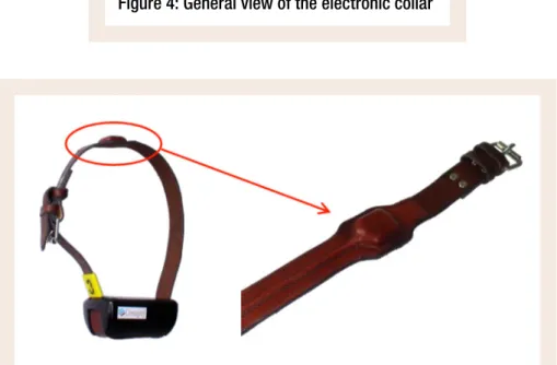
Figure 4 presents a prototype of the collar with its two main elements: • a black box where the electronic parts are placed,
• a belt where the GPS antenna is integrated.
Figure 4: General view of the electronic collar
Figure 5: The position of the GPS antenna
The antenna is placed outside the black box, at the top of the collar, in order to obtain a good re-ception from the GPS satellite. Figure 5 shows the antenna and the coaxial cable which are sewn inside the leather collar for protection.
35
OTAG - OperATiOnAl MAnAGeMenT And GeOdecisiOnAl prOTOType TO TrAck And TrAce AGriculTurAl prOducTiOn
Power supply management
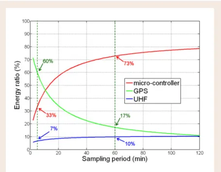
Energy consumption is a very important aspect for the autonomy of the equipment and numer-ous studies have been performed on this topic. Particularly, the necessary energy to read, store and transfer GPS data has been estimated considering:
• the different electronic elements in the collar (GPS, UHF system, micro-controller), • the internal software managing these elements,
• the sampling period of the GPS data which constitutes significant parameter.
It is then possible to study how the energy of the battery is used in the collar. This is the result obtained with the first prototype of the collar (it is the collar we have used during the demonstra-tion yesterday). The chart represents all the energy of the battery inside the collar. Simulademonstra-tions have been done in order to estimate the distribution of the energy between all the elements as a function of the sampling period: i)~for a sampling period of five minutes, the GPS is the biggest energy-consuming device, the UHF and the micro-controller have similar energy consumption levels; ii)~when the sampling period increases, GPS consumption decreases (as well as UHF con-sumption). And finally, for long sampling periods, the micro-controller is the biggest energy-consuming device (see Figure 6).
According to simulations, the lifetime of the collars could be estimated in function of the sam-pling rate. Simulation results show that for a samsam-pling rate of one acquisition per hour, the life-time of the collar would be of around 1 year.
Figure 6: Evolution of energy consumption in function of the sampling rate
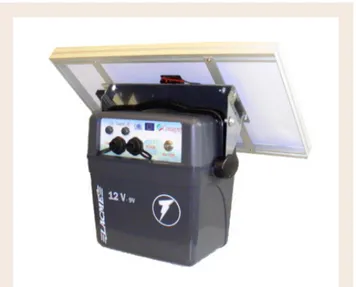
Figure 7: General view of the base station
Base station
The second element developed is the base station (see Figure 7). The housing used is that of a an electric fence generator developed by LACME Company. A solar panel is also used in order to increase energy autonomy of the base station.
The general architecture of the base station, presented in Figure 8 is as follows:
• the whole system is based on a PC with a Microsoft Windows operating system. It is a one hundred and four (104) PC, because the computer is small; it is a low energy-consuming system because this kind of computer functions within a large range of temperatures (posi-tive and nega(posi-tive);
• a GPS and its antenna to measure the position of the base station; • the UHF system to communicate with the collars;
• a power management system controls the supply of the whole base station using a battery and a solar panel;
• we are not using screen and keyboard to control the PC because these interfaces are not adapted to the outdoor environment. Instead we are using a touch-sensitive screen which is connected to the Ethernet network;
• and a USB connector to allow the operator to collect all data from the collars, which is stored in the PC memory.
37
OTAG - OperATiOnAl MAnAGeMenT And GeOdecisiOnAl prOTOType TO TrAck And TrAce AGriculTurAl prOducTiOn
Figure 8: General architecture of the base station
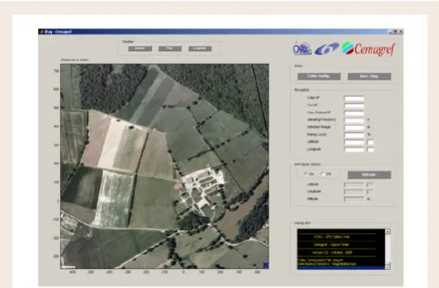
Base station software development
The last point concerns the different kinds of software that have been developed for the base sta-tion. The objective of this software is:
• to read the GPS data from all collars • to save this data in identified files
• and to make these files available to the operator
A graphic interface has been developed which integrates these algorithms in order to show and explain the whole functioning of the system (see Figure 9).
Towards a Spatial Decision Support System
for Animal Traceability
M. Visoli, S. Ternes – Embrapa ; S. Bimonte, F. Pinet, J.P. Chanet – Cemagref
This section presents the contributions of our work to the problems of bovine traceability and contact between animals using trajectory database concepts. This section describes how to de-limitate problems and how to represent animal movements as trajectories. Afterwards, the al-gorithms for the identification of contacts between animals are presented for the calculation of contamination probabilities.
In this work we define contamination algorithms for foot-and-mouth disease (FMD). FMD is a highly contagious disease that attacks all cleft-hoofed animals, mainly bovines. It occurs at all ages, regardless of sex, breed, climate, etc. The virus spreads by direct contact of animals as well as through the air, water and food.
The virus is present in high concentrations in the liquid of vesicles of the mucous membranes of the tongue and in the soft tissues around the hooves. There are high concentrations of virus in the blood during the initial phases of the disease, during which there are serious infection risks to other animals. Sometimes infection can be indirect, the virus is carried through the food, wa-ter, air and birds. Likewise, people taking care of the sick animals carry the virus on their hands, clothes or footwear, therefore contaminating healthy animals. The incubation period varies from eighteen hours to three weeks.
In this work we consider two parameters for the calculation of contacts within the trajectory concept, which are set for FMD but that are common to other diseases as well. The first one is the number of days necessary to guarantee that no contamination has occurred: 90 days. This period determines a time interval where contacts must be calculated for later verification. The second factor is the area within the premises that must be interdicted. Initially, it is possible to use theses values to determine the size of an activity area (buffer) and subsequent contact between animals. Finally, we make a realistic assumption on the geographic location of animal movements, which allows to improve the performance of contact computation as it reduces the number of trajecto-ries considered by our algorithm. Indeed, we consider scenarios wherein farms use extensive and semi-extensive production systems. This means that animals can move between paddocks under the control of farmers.
The movement of animals between farms or from farms to slaughterhouses, which is done through roads, can be deduced and studied by analysing the existing road structure, however, this is not the subject matter of our work. We are interested in bovine movements into farms and, more specifically, into paddocks.
The data generator produces points representing animal positions inside the paddocks. For each point, geographical coordinates and time data (day and time) are collected. Thus, the following step is to transform these points into information representing the movements of the animals in
39
OTAG - OperATiOnAl MAnAGeMenT And GeOdecisiOnAl prOTOType TO TrAck And TrAce AGriculTurAl prOducTiOn
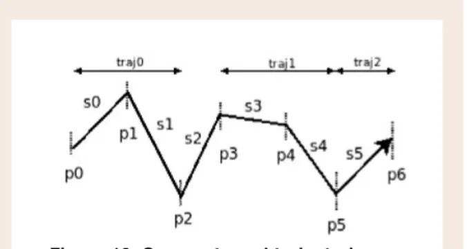
a format that allows advancing towards more intelligent operations. For this purpose, we con-sider that movement between two points is carried out in a straight-line. Based on this assump-tion, we have proposed a model of trajectories. In order to represent the trajectory of animals, we provide the definitions of point, segment, trajectory and journey.
Definition
• point: a point is a geo-localised acquisition represented by the geographical position and its
associated time (day and time).
• segment: a segment is a line connecting two consecutive points in a ordered list of points
throughout time.
• trajectory: a trajectory is a sequential set of segments, in accordance with the semantics
de-fined by the decision-maker.
• journey: set of trajectories.
The semantics determining the beginning and end of a trajectory depend on what is being ob-served. For example, in our case study, beginning and end may be associated with the entry of the animal in the farm and its exit. Another example can correspond to the first and last day of protection against disease associated to some vaccination. An example is shown in Figure 10. Three classes have been created: Journey,
Trajectory and Segment. Segment is the simplest class and it represents collected points. Trajectory is an aggregation of segments, and Journey is an aggregation of trajectories.
Two important variables for the algo-rithms of contact between animals and calculation of the contamination per-centage have been considered: Activity area and IBC.
Definition
• Activity area: is the buffer zone around a trajectory where there is a probability of con-tamination (see figure 12). Buffer represents a zone around the trajectory with an identical distance for each one of the sides;
• Interval between contacts (IBC): is a time range that represents the number of days dur-ing which there is contamination risk (see Figure 12).
FMD belongs to a group of diseases that are transmitted from a distance from the contaminated animal. Distance from the trajectory may vary depending on the wind, relief or rains. In our work we consider a distance of 3 km.
Figure 11: Trajectories and IBC
Figure 12: Trajectory and buffer (activity area)
Finally, when considering the transmission of a disease as FMD, it is not only necessary to verify the intersection or crossing of trajectories, but also to try to delimit an area around the trajec-tory (buffer), and to verify the intersection of these areas with animal trajectories. Thus, before formalizing contamination contact taking into account IBC and Activity Area let us introduce Temporal Contact, Spatial Contact and Spatial-Temporal Contact.
Definition
• Temporal contact: If trajA is the trajectory of animal A and IBCtrajA is the subtrajectory of
trajA having IBC boundaries as starting and ending times. Being trajB the trajectory of animal B. Temporal contact exists when there is a temporary intersection between IBCtrajA and trajB.
• Spatial contact: If trajA is the trajectory of animal A and ACTtrajA is the Activity Area of
trajA. Being trajB the trajectory of animal B. Spatial contact exists when there is a topological intersection between ACTtrajA and trajB.
• Spatial-temporal contact: If trajA is the trajectory of animal A and is trajB is the trajectory of animal B. Spatial-temporal contact occurs when there are temporal contact and spatial contact.
Two algorithms have been developed to calculate spatial-temporal contacts between animals ac-cording to the time units used to define segments: day and hour.
The two techniques proposed have been tested on simulated data to find contaminated animals that have been in contact, according to three kinds of contacts defined.
As a conclusion, the traceability information system presented herein has proved to have the potential to increase product quality and trustworthiness as it improves the precision of the traceability process. The proposal focuses on an important target that involves a large number of actors around a relevant subject in what regards human health. This information system should be useful for government institutions and farmers in case of a relapse, saving time, costs and contributing to achieve food safety.