HAL Id: hal-02150379
https://hal.archives-ouvertes.fr/hal-02150379
Submitted on 7 Jun 2019
HAL is a multi-disciplinary open access
archive for the deposit and dissemination of
sci-entific research documents, whether they are
pub-lished or not. The documents may come from
teaching and research institutions in France or
abroad, or from public or private research centers.
L’archive ouverte pluridisciplinaire HAL, est
destinée au dépôt et à la diffusion de documents
scientifiques de niveau recherche, publiés ou non,
émanant des établissements d’enseignement et de
recherche français ou étrangers, des laboratoires
publics ou privés.
climate change on inland waterways
Guillaume Lozenguez, Pablo Segovia Castillo, Guillaume Desquesnes, Arnaud
Doniec, Éric Duviella, Fatiha Nejjari Akhi-Elarab, Vicenç Puig, Lala
Rajaoarisoa
To cite this version:
Guillaume Lozenguez, Pablo Segovia Castillo, Guillaume Desquesnes, Arnaud Doniec, Éric Duviella,
et al.. Management tools to study and to deal with effects of climate change on inland waterways.
Academic Open Internet Journal, Bourgas University, Technical College, 2018. �hal-02150379�
Proceedings of 7th Transport Research Arena TRA 2018, April 16-19, 2018, Vienna, Austria
Management tools to study and to deal with effects of climate
change on inland waterways
P. Segovia
a,b,c, G. Desquesnes
a, A. Doniec
a, E. Duviella
a*, G. Lozenguez
a, F. Nejjari
b,
V. Puig
b,cand L. Rajaoarisoa
aaInstitut Mines Telecom Lille Douai, Univ. Lille, URIA, Lille, France
{ pablo.segovia, guillaume.desquesnes, arnaud.doniec, eric.duviella, guillaume.lozenguez, lala.rajaoarisoa}@imt-lille-douai.fr
b
Automatic Control Department, Technical University of Catalonia (UPC), Spain { pablo.segovia, fatiha.nejjari, vicenc.puig}@upc.edu
cInstitut de Robòtica i Informàtica Industrial (CSIC-UPC), Barcelona, Spain
Abstract
Inland navigation transport takes part in the Trans-European network program (TEN-T*), which aims at promoting this mode of transport by creating favorable conditions for the further development of this sector. The NAIADES† Action Program comprises numerous actions and measures to boost transport on inland waterways. Among these actions, the infrastructure issue is dealt with. It requires the inventory of the existing infrastructure and the study of the possible effects of the expected climate change. This was one of the objectives of the GEPET-Eau‡ project (2013-2016), which led to the proposal of multi-scale modeling approaches and adaptive and predictive control architectures. The resilience of inland waterways against the increase of navigation demand and the expected extreme drought and flood events was studied by considering deterministic models. The proposed architecture is suitable to consider two scales of space and time to optimize the water resource allocation among the inland networks and to guarantee the navigation conditions by proposing advanced control and fault detection tools. These approaches, which were designed by considering inland waterways in the north of France, are still being improved. Indeed, it is firstly necessary to consider all the uncertainties that are inherent to large-scale and environmental systems. Secondly, the advanced control and fault detection tools require further development to deal with the very complex dynamics that characterize inland waterways. The main objective of this work is to present the current state of the tools that have been developed in order to study and manage the inland waterways in a climate change context. The global framework that allows describing the link between these two management scales will be detailed. The water resource allocation approach can be based on three different techniques: the Constraint Satisfaction Problem (CSP), the quadratic optimization and the Markov Decision Process (MDP). The MDP-based approach will be emphasized due to its suitability to study complex systems with uncertainties, and its main advantages and drawbacks will be discussed and compared to the other techniques. Advanced control and fault detection tools require an in-depth knowledge of the inland waterway dynamics. Characteristics of navigation reaches, i.e. slope, resonance phenomenon, uncontrolled inputs and interconnections, need to be taken into account. A big effort has been made to improve the modeling step of the navigation reaches by considering the IDZ (Integrator Delay Zero) model. The designed tools are based on this accurate model, and they aim at improving the water level control of each reach of the inland waterways and at performing predictive maintenance strategies by detecting, isolating and forecasting faults on sensors and actuators (limnimeters, gates, locks, etc.). The designed management tools will be presented by considering a part of the real inland navigation network in the north of France. Perspectives and future developments will be described.
Keywords: Inland water transport, Climate change, Management, Optimization, Modeling, Control.
** http://ec.europa.eu/transport/modes/inland/promotion_en †
http://ec.europa.eu/transport/modes/inland/promotion/naiades_en
1. Introduction
Inland waterways transport takes part in the multimodal transport (Wiegmans and Konings, 2015) promoted by the Trans-European network program (TEN-T). It offers not only several economic and environmental benefits (Mihic, 2011; Mallidis, 2012), but also constitutes a safer manner of transporting goods (Brand, 2012). This perspective is shared by the IPCC (Intergovernmental Panel on Climate Change) which indicated that it is possible to limit climate change and its risks by technical and behavioral mitigation measures that could reduce
final energy demand significantly below baseline levels (IPCC, 2014). The shift of road transport to alternative
transport solutions necessitates the delivery of new infrastructures. In the domain of inland waterway transport, some projects such as the Seine-Nord canal in France and numerous actions and measures proposed by the NAIADES Action Program should boost transport on inland waterways. However, these infrastructure projects require heavy financing as well as social and environmental agreements. The political decisions that must be made can cause time delays in the completion of these projects. Until then, it is necessary to optimize the management of inland waterways, particularly in a context of climate change and expected increase of navigation demand. The possible climate change impacts on inland waterways have been studied by the PIANC (Permanent International Association of Navigation Congresses) (EnviCom, 2008) and during the ECCONET Project§. Others studies (Bates et al., 2008; Wanders and Wada, 2015; IWAC, 2009; Arkell and Darch, 2006; Pant et al., 2015) have concluded that inland waterways will be impacted by climate hazard. According to (Beuthe et al., 2014), the impacts of climate change on the Rhine and Danube corridors should be more moderated. In addition, the navigation demand should increase in the not-too-distant future in several parts of the world such as Poland (Gołębiowski, 2016) and China (Jiang et al., 2017). Hence, it is necessary to anticipate these potential impacts.
This was the main objective of the GEPET-Eau project (2013-2016) that led to the proposal of optimal management architecture (Duviella et al., 2013b) and of the following studies that are still in progress. The optimal management architecture is based on multiscale tools (Duviella et al., 2014). The first scale of space and time that corresponds to several interconnected navigation reaches and several days is dedicated to the optimal water resource allocation. It aims at guaranteeing that sufficient water volumes are available in each part of the studied network over the corresponding management period for normal, drought or flood conditions. A methodology of adaptive allocation planning of water resource is proposed in (Nouasse et al., 2016a). It can be based on CSP (Constraint Satisfaction Problems) (Nouasse et al., 2016b) or on QOP (Quadratic Optimization Problems) (Duviella et al., 2016). In addition, it makes possible to determine the resilience of the network against these conditions (Desquesnes et al., 2016). These proposed approaches for water allocation planning are deterministic. Some recent improvements allow taking into account uncertainties that are inherent to large-scale and environmental systems. These new techniques are based on distributed Markov Decision Process (MDP) (Desquesnes et al., 2017a). The second scale of space and time that corresponds to some interconnected navigation reaches and several minutes is dedicated to the optimal control of the water levels. It aims at guaranteeing the navigation conditions at each time step by proposing advanced control and fault detection tools. Control approaches based on Model Predictive Control (MPC) with an Integral Delay Zero (IDZ) and Integral Resonance (IR) models have been designed respectively in (Horváth et al., 2014c; Horváth et al., 2015) and in (Horváth et al., 2014d). The proposed control methods still require further development to deal with the very complex dynamics that characterize inland waterways and with the occurrence of sensor and actuator faults that can undermine the performance of the controllers. It requires an in-depth knowledge of the inland waterway dynamics, which are characterized by no slope, resonance phenomena, uncontrolled inputs and interconnections among navigation reaches. A big effort has been carried out to improve the modeling step of the navigation reaches by considering the IDZ (Integral Derivative Zero) model (Segovia et al., 2017b). Moreover, Fault-Tolerant Control (FTC) has been proposed in (Segovia et al., 2016) to improve the water level control by detecting, isolating and forecasting faults on sensors and actuators (limnimeters, gates, locks, etc.) (Segovia et
al., 2017a).
The main objective of this paper is to present the current state of the tools that have been developed in order to study and manage the inland waterways in a climate change context. Its content is structured as follows: Section 2 is dedicated to the description of the global framework that allows gathering the tools dedicated to the two management scales. A software tool that has been developed to study the impacts of climate change or the increase of navigation demand by defining the characteristics and the configuration of inland waterway to be considered is presented. A simulation architecture that has been developed to test the adaptive allocation
Segovia et al. / TRA2018, Vienna, Austria, April 16-19, 2018
planning of water resource is detailed. The optimal water resource allocation planning approaches (QOP, CSP and MDP) are introduced, and their main advantages and drawbacks are discussed. Section 3 is dedicated to the modeling and control techniques of navigation reaches that are characterized by no slope. Moreover, elements for the design of controller and Fault Tolerant Control are given. Finally, conclusions about the performed work are drawn in Section 4.
2. Management architecture for inland water networks
2.1. Description
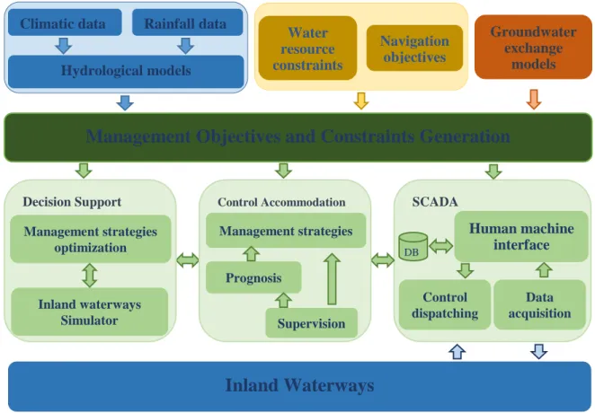
The adaptive control management architecture of inland waterways proposed in (Duviella et al., 2014) is depicted in Fig. 1. Its functionalities are kept but some improvements have been made. The sensors that are located along the navigation canals provide data such as water levels and discharges. A Human Machine Interface (HMI) allows the waterways managers to monitor the state of the system and to define setpoints that must be applied by means of actuators such as controlled gates and locks. Local control algorithms are implemented to keep the water level of the navigations reaches close to the defined setpoints. A module entitled Control Accommodation gathers the Fault Tolerant Control functionalities. They aim at detecting the occurrence of faults on sensors and actuators, at localizing these faults and at accommodating the control laws to guarantee the management objectives. Furthermore, the prognosis block can be designed to follow the drifts of the faults and forecast their occurrence time. All these functionalities correspond to the lower management scale, i.e. several minutes and limited to some navigation reaches. The Decision Support module is dedicated to the water volume management that aims at dispatching the water volumes among all the waterways. It is based on optimization techniques that must take into account information from watersheds (such as rainfall/runoff models) that lead to estimate the water volumes that are due to rainfall; from groundwater, to estimate the water exchanges; and from climate change scenarios that predict the possible climate events, when this information is available.
Fig. 1 Adaptive control management of inland waterways.
The decision support module has been improved recently. Its implementation requires the proposal of an integrated dynamic model of inland waterways to inventory interactions between navigation reaches and natural
Management Objectives and Constraints Generation
Climatic data
Hydrological models
Rainfall data
Navigation
objectives
Water
resource
constraints
Groundwater
exchange
models
SCADAHuman machine
interface
Control dispatching Data acquisition DB Decision Support Management strategies optimization Inland waterways Simulator Control Accommodation Management strategies Supervision PrognosisInland Waterways
rivers, and a dynamic directed flow graph to generate the constraints on the operating conditions of the controlled hydraulic structures (Nouasse et al., 2015). The use of these tools requires a specific study for each inland waterway that can be considered. Hence, to facilitate their use, a software tool has been developed (Mayet
et al., 2016). It is based on a web interface and users can describe very easily the configuration of inland
navigation networks and define several scenarios.
2.2. Optimal water resource allocation planning software 2.2.1. User’s web-interface
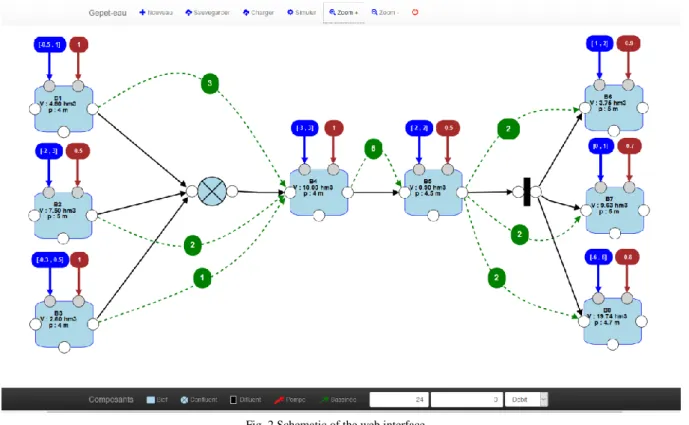
A user’s web-interface has been developed for the optimization of water management in inland waterways. It allows the implementation of any configuration of waterways by considering as elementary component the navigation reaches, i.e. the part of waterways between at least two locks, two gates or a combination of these hydraulic devices. The designed interface uses HTML 5, CSS and three frameworks Javascript: jointJS for the diagrams, JQuery for user’s events and Bootstrap for the graphical elements: buttons, edit text, etc. Figure 2 illustrates the designed tool, and the considered inland waterway is composed of 8 navigation reaches (cyan rectangles). The interactions between them are represented with arrows and tributary and distributary elements for confluents and diffluents.
Fig. 2 Schematic of the web interface.
The characteristics of the navigation reaches (width, length and depth) can be specified. The navigation conditions (with the high and low water level limits for navigation) must be specified too. Then, the dimensions of the locks, i.e. the volume corresponding to one lock operation, the operating range of the controlled gates and hydraulic devices can be implemented. The rectangles in dark blue specify the operating ranges of the hydraulic structures of the watershed (input or outputs from the inland waterways). The rectangles in red specify the value of the discharges that come from uncontrolled hydraulic structures such as weirs or spillways. The number of expected lock operations is indicated in green circles.
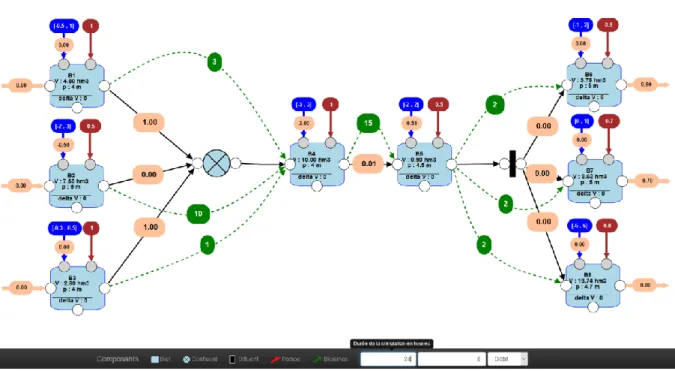
Once the configuration of the inland waterway is completed, it is possible to generate scenarios. The navigation period of a day can be modified (for instance, the navigation is restricted to 12 hours/day). Periods of drought or flood can be simulated by increasing or decreasing the available water resource. Based on the implemented scenario, the proposed tool makes possible the optimization of the water resource allocation planning. It is achieved by defining a Constraint Satisfaction Problem (CSP) that is solved with the CSP method based on the Open Source Java Choco (Jussien et al., 2008). Several case studies have been proposed in (Nouasse et al., 2016a; Nouasse et al., 2016b). When a solution is obtained, results are shown in discharges or in volumes on
Segovia et al. / TRA2018, Vienna, Austria, April 16-19, 2018
each arc in pink rectangles (see Fig. 3).
Fig. 3 Screenshot of the web interface with new setpoint.
In addition, this tool allows studying the resilience of inland waterways with a simple and faster way. It consists in simulating several extreme scenarios for which at least one navigation reach cannot guaranty the navigation conditions.
The proposed user’s web-interface is very useful to implement a configuration of a waterway and to specify the scenarios. However, the implemented CSP method allows only one simulation step. In order to consider large management horizons, a simulation architecture based on Matlab has been designed, which is associated with the user’s web-interface.
2.2.2. Matlab/Simulink simulation architecture
Matlab/Simulink is a powerful tool that can be used to simulate the dynamics of inland waterways by considering large simulation horizon. It offers the possibility to link it easily with the designed user’s web-interface and several optimization tools such as CSP – Open Source Java Choco, QOP (Quadratic Optimization Problems) or decentralized MDP (Markov Decision Process). The proposed simulation architecture allows the user to select the optimal water resource allocation planning approach. Thus, from the user’s web-interface, a Simulink model is designed by taking into account the configuration of the network, the constraints and the proposed scenario (see 1 in Fig. 4). The Simulink model is run during the management horizon TM with a discrete time kM [h], where kM=k·TM. The optimal water resource allocation method is selected by the user (see 2 in Fig. 4). At each step time k, the current states of the navigation reaches (their levels) and the forecasted navigation demand are sent to the optimization approach, and new setpoints are computed before being sent to the Simulink simulator for a new run of a simulation step. At the end of the simulation, the results can be seen according to user’s interface.
Fig. 4 Simulation architecture.
Matlab/
Simulink
1 2 kCSP - Choco
QOP - Matlab
MDP
The QOP approach has been used in (Nouasse et al., 2016c; Duviella et al., 2016) by considering an inland waterway equipped with pumps. An algorithm was proposed to guarantee the navigation condition by minimizing the electric cost due to the use of the pumps. The main advantage of this approach is that it is possible to consider continuous data and no discretization of the variables is required. The decentralized MDP offers the advantage to consider the uncertainties that are inherent to large-scale and environmental systems. This approach has been used in (Desquesnes et al., 2016; Desquesnes et al., 2017a) by considering realistic inland waterways and a real inland waterway that is located in the north of France. Its main drawback can be avoided by proposing a decentralized implementation that is based on multi-agents (Desquesnes et al., 2017b). Therefore, it requires a discretization of the variables as the CSP approach.
3. Modeling and Control of inland navigation reach
The Control Accommodation module of the architecture given in Fig. 1 is dedicated to the control of water levels with a sample time of several minutes. This objective is achieved by designing control laws that must be applied by the controlled devices such as gates. However, it is also necessary to anticipate the problems that might derive from the occurrence of faults on sensors and actuators. Hence, a Fault-Tolerant Control (FTC) approach has to be designed (Segovia et al., 2016). It aims at allowing the system to continue operating properly despite fault occurrences (Horváth et al., 2014a). This control approach is usually based on Fault Detection and Isolation techniques (FDI), which have been widely proposed for free-surface water systems in the last years. They can be based on models of the systems (Bedjaoui and Weyer, 2011; Nabais et al., 2012; Blesa et al., 2014; Segovia et
al., 2017a), on measured data (Le Pocher et al., 2012; Akhenak et al., 2013; Duviella et al., 2013a) or on both
(Horváth et al., 2014b). Several control approaches have also been proposed in the literature (Litrico and Fromion, 2009; Malaterre et al., 2014; Pham et al., 2014; Raievsky, 2014; Rajaoarisoa et al., 2014; Fele et al., 2014), mainly based on an accurate model of the free-surface water systems. However, specific characteristics of flat navigation reaches, i.e. characterized by no slope, such as strong resonance phenomena have not been taken into account. The contributions of the last year are dedicated to the modeling and the control approaches of inland navigation reaches without slope (Segovia et al., 2017b).
3.1. Modeling
A natural way to model the dynamics of inland navigation networks is to decompose it in reaches, which in addition simplifies the modeling task. The dynamics of these reaches can be accurately described by the Saint-Venant partial differential equations (Chow, 1959). However, it is difficult to design control and FDI approaches based on these equations. Moreover, there is no known analytical solution for this set of equations. Furthermore, small errors in the geometry and other parameters of the reaches can lead to important errors in the computation of the models. All these reasons have fostered the development of simplified models have been proposed in the literature. Among all the proposed approaches, the Integrator Delay Zero model proposed in (Litrico and Fromion, 2004) presents an easy parameter identification step based on the physical characteristics of the reach. In addition, this model allows reproducing low and high frequency dynamics. Its structure is as follows:
( )
(1)
with α the inverse of the transfer function zero, A the integrator gain and τ the propagation time delay.
In low frequencies, the behaviour of the canal is similar to a tank. The integrator gain accounts for the change of the water volume according to the variation of the water level. The time delays represent the minimum time that a wave needs to travel from its origin to the measurement point. Two different time delays have to be computed:
(from upstream to downstream) and (from downstream to upstream):
(2.1)
(2.2)
with L [m] the total length of the canal, the water celerity [m/s] and the water velocity [m/s].
The high frequency dynamics are dominated by the zero of (1), which reproduces the first peak in the water level. In (Litrico and Fromion, 2004), these parameters are computed for the upstream uniform and the
Segovia et al. / TRA2018, Vienna, Austria, April 16-19, 2018
downstream backwater flow parts of the canal, which are then merged into the so-called equivalent parameters that describe the whole canal. Nevertheless, for flat canals, there is no upstream uniform flow part, and therefore the parameters only have to be calculated for the backwater part.
[ ( ) ( )] ( ) ( ) [ ̂ ( ) ̂ ( ) ̂ ( ) ̂ ( ) ] [ ( ) ( )] (3)
where 0 and L are the abscissas for the upstream and downstream ends of the reach; y(0,s) and y(L,s), the upstream and downstream water levels; ̂ ( ), the estimation of the IDZ expressions given in (1); and q(0,s) and q(L,s), the upstream and downstream water discharges, respectively.
3.2. Controller design
The control approach has been designed for a single reach (Horváth et al., 2014a) and for interconnected reaches (Segovia et al., 2017c). Some elements of the controller are given herein (further details can be obtained in the referenced papers). The following step consists in the discretization of the transfer function (3) at the sample time k. Then, the model is transformed to a minimal state-space model:
{ ( ) ( ) ( )
( ) ( ) (4) with matrices A∈Rn×n, B∈Rn×m and C∈Rr×n, n the number of states, m the number of inputs and the number of
measured variables, x(k) the state variable, u(k) the change of the discharge and y(k) the water level error. Then, by extending the state variable as z(k)=[xT (k),Qd (k)]T, it is possible to formulate constraints on the input discharges Qd (k). The obtained model is:
{ ( ) ̂ ( ) ̂ ( )
( ) ̂ ( ) (5) where Im∈R
m×m
is the identity matrix. Finally, the control approach is expressed as a quadratic programming problem that consists in minimizing the following objective function on the future control horizon λ:
( ) ∑ ( | )
( ( | ) ( | ) ( | ))∈ ( | )
∑ ( | ) ( | ) (6) subject to the following constraints: ( | ) , where P and R are weighing matrices and zmin
and zmax are the boundaries of the variable z.
3.3. Fault-Tolerant Control 3.3.1. Definition
The Fault-Tolerant Control proposed in (Segovia et al., 2016) has been designed for interconnected navigation reaches. The conventional FTC configuration is depicted in Fig. 5. It is composed of a controller that aims at determining a command u(s) in order to obtain as the output of the real system a measurement y(s) equal to the reference yref. This controller can be accommodated according to the detected faults that come from the Estimator module. This means that the controller parameters can be adapted, or at least the measured data can be corrected, i.e. ycorr. The strategy depends on the type of faults (sensor or actuator faults).
Fig. 5 Fault Tolerant control framework.
For interconnected systems such as inland navigation reaches, it is often necessary to take into account the measurements that come from the n sensors, and to control the m actuators that equipped the waterways. The conventional FTC configuration that is depicted in Fig. 5 has to be adapted to take into account this particularity
Real System
Controller
Sensor
Estimator
such as it is described in (Segovia et al., 2016).
3.3.2. Fault Detection and isolation
The proposed FTC framework is based on FDI techniques to detect and isolate the faults. The accommodation of the controller depends on this detection scheme. An FDI approach for flat navigation reaches is proposed in (Segovia et al., 2017a). It is based on the generation of residuals between the real system and the quantitative model of the reach: the more reliable the model, the better the fault detection performance. The big effort made regarding the modeling part (Segovia et al., 2017b; Segovia et al., 2017d) obeys this principle. The reader is referred to the papers cited above for more details about the developed FDI approaches.
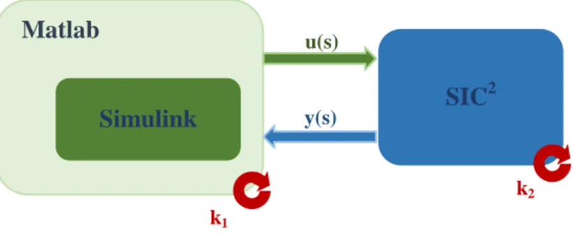
3.4. Simulation architecture
The modeling, control, FDI and FTC approaches must be designed and tested according to real systems. However, it is usually difficult to test the designs in real systems because inland waterways are being used constantly, and it is practically impossible to stop navigation to conduct tests. The conventional design step consists in using simulators of the real systems. Hence, real systems are implemented on the software SIC2**, which solves numerically the Saint-Venant equations. It is possible to simulate their dynamics and compare them to the observed ones. The next step consists in building a simulation framework to test (by simulation) all these developments. The simulation architecture, depicted in Fig. 6, is based on the link between SIC2 and Matlab/Simulink, where the control, FDI or FTC algorithms are implemented. SIC2 starts the simulation and loads Matlab. SIC2 is run with a period k2; at the end of each period, SIC
2
pauses. The states of the system, i.e. the water levels y(s), are sent to the workspace of Matlab. Simulink then starts running with period k1 (with k1≥ k2). At the end of the period k1, the new commands that are computed according to the implemented control/FTC
laws are sent to SIC2, and a new cycle starts.
Fig. 6 Simulation architecture.
This architecture benefits from a software dedicated to the simulation of free-surface water systems and a software tool dedicated to the design of control/FTC algorithms. It has been used for the design of controllers, FDI and FTC of real navigation network located in the north of France.
4. Conclusions
The objective of this paper is to present an architecture dedicated to the optimal management of inland waterways. This architecture gathers tools for the optimal water resources allocation based on CSP, QOP and MDP. The new developments are dedicated to distributed MDP that allows dealing with uncertainties. The main advantages and drawbacks of this method compared to CSP and QOP are discussed. These optimal water resources allocation methods lead to the determination of setpoints by considering large inland waterways and large time horizons. Once these setpoints are determined, it is still necessary to design Fault-Tolerant Control strategies to guarantee these objectives. These strategies are based on control laws and FDI algorithms to guarantee the navigation conditions, i.e. water level objectives, even if sensor and/or actuator faults occur. The control and FTC approaches are based on modeling techniques that must be as accurate as possible. The main contributions for the optimal management of inland waterways in the context of climate change and expected increase of the navigation demand are presented. However, it is still necessary to develop them to be able to boost the navigation as a suitable transport mode.
** http://sic.g-eau.net/preambule
Matlab
SIC
2Simulink
u(s) y(s) k1 k2Segovia et al. / TRA2018, Vienna, Austria, April 16-19, 2018
5. References
Akhenak, A., Duviella, E., Bako, L., Lecoeuche, S., 2013. On-line Fault Diagnosis using Recursive Subspace Identification Algorithm of a Dam-Gallery Open Channel System. In Control Engineering Practice, volume 21, issue 6, pp 797-806.
Arkell, B.P., Darch, G.J.C. ., 2006. Impact of climate change on London's transport network. In Proceedings of the ICE - Municipal Engineer, volume 159, issue 4, pp. 231-237.
Bates, B., Kundzewicz, Z., Wu, S., Palutikof, J., 2008. Climate change and water. In Technical repport, Intergovernmental Panel on Climate Change, Geneva.
Bedjaoui, N., Weyer, E., 2011. Algorithms for leak detection, estimation, isolation and localization in open water channels. In Control Engineering Practice, volume 19, issue 6, pp 564-573.
Beuthe, M., Jourquin, B., Urbain, N., Lingemann, I., Ubbels, B., 2014. Climate change impacts on transport on the Rhine and Danube: A multimodal approach. In Transportation Research Part D: Transport and Environment, volume 27, pp. 6-11.
Blesa, J., K. Horvàth, K., Duviella, E., Puig, V., Bolea, Y., Rajaoarisoa, L., Chuquet, K., 2014. Model-based sensor supervision in inland navigation networks: Cuinchy-Fontinettes case study. In Journal Maritime Research, volume 11, issue 2, pp 81-88.
Brand, C., Tran, M., Anable, J., 2012. The UK transport carbon model: An integrated life cycle approach to explore low carbon futures. In Energy Policy, volume 41, pp. 107-124.
Chow, V. T., 1959. Open-channel hydraulics. In McGraw-Hill. New York.
Desquesnes, G., Lozenguez, G., Doniec, A., Duviella, E., 2016. Dealing with Large MDPs, case study of waterway networks supervision. In PAAMS, Sevilla, Spain, 1-3 June.
Desquesnes, G., Lozenguez, G., Doniec, A., Duviella, E., 2017a. Large Markov Decision Processes Based Management Strategy of inland waterways in uncertain context. In SimHydro 2017, Sofia Antipolis – Nice, 14-16 June.
Desquesnes, G., Lozenguez, G., Doniec, A., Duviella, E., 2017b. Distributed MDP for water resources planning and management in inland waterway. In IFAC WC, Toulouse, France, 9-14 July.
Duviella, E., Rajaoarisoa, L., Blesa, J., Chuquet, K., 2013a. Fault Detection and Isolation of inland navigation channel: Application to the Cuinchy-Fontinettes reach. In 52nd IEEE Conference on Decision and Control, Florence, Firenze, Italy, December 10-13.
Duviella, E., Rajaoarisoa, L., Blesa, J., Chuquet, K., 2013b. Adaptive and predictive control architecture of inland navigation networks in a global change context: application to the Cuinchy-Fontinettes reach. In: IFAC MIM conference, Saint Petersburg, June 19-21.
Duviella, E., Horvàth, K., Rajaoarisoa, L., Chuquet, K., 2014. Multi-scale modeling approaches of inland navigation networks for their management in a global change context. In Transport Research Arena, Paris La Défense, France, April 14-17.
Duviella, E., Nouasse, H., Doniec, A., 2016. Dynamic Optimization Approaches for Resource Allocation Planning in Inland Navigation Networks. In ETFA’2016, Berlin, Germany, September 6-9",
EnviCom, 2008. Climate Change and Navigation - Waterborne transport, ports and waterways: A review of climate change drivers, impacts, responses and mitigation. In EnviCom - Task Group 3.
Fele, F., Maestre, J.M. , Mehdy Hashemy, S., Muñoz de la Peña, D., Camacho, E.F., 2014. Coalitional model predictive control of an irrigation canal. In Journal of Process Control, volume 24, issue 4, pp. 314 – 325.
Gołębiowski, C., 2016. Inland Water Transport in Poland. In: Transportation Research Procedia, volume 14, Supplement C, pp. 223-232. Jiang, Y., Jing, L., Cai, Y., Zeng. Q., 2017. Analysis of the impacts of different modes of governance on inland waterway transport
development on the Pearl River: The Yangtze River Mode vs. the Pearl River Mode. In: Journal of Transport Geography.
Horváth, K., Blesa, J., Duviella, E., Chuquet, K., 2014a. Fault tolerant model predictive control of open channels. In USCID Water Management Conference, Phoenix, Arizona, USA, 2-5 December.
Horváth, K., Blesa, J., Duviella, E., Rajaoarisoa , L., Puig, V., Chuquet, K., 2014b. Sensor fault diagnosis of inland navigation system using physical model and pattern recognition approach. In IFAC World Congress, Cape Town, South Africa, 24-29 August.
Horvath, K., Petrecsky, M., Rajaoarisoa, L., Duviella, E., Chuquet, K., 2014c. MPC of water level in a navigation canal - The Cuinchy-Fontinettes case study. In European Control Conference, Strasbourg, France, 24-27 June.
Horvath, K., Duviella, E., Petrecsky, M., Rajaoarisoa, L., Chuquet, K., 2014d. Model predictive control of water levels in a navigation canal affected by resonance waves. In HIC 2014, New York, USA, 17-21 August.
Horváth, K., Duviella, E., Rajaoarisoa, L., Negenborn, R., Chuquet, K., 2015. Improvement of the navigation conditions using a Model Predictive Control - The Cuinchy-Fontinettes case study. In International Conference on Computational Logistics, Delft, The Netherlands, 23-25 September.
IPCC 2014, Climate Change 2014. The Core Writing Team, R. K. Pachauri and L. Meyer, Synthesis Report, https://www.ipcc.ch/pdf/assessment-report/ar5/syr/SYR\_AR5\_FINAL\_full.pdf
IWAC, 2009. Climate change mitigation and adaptation. Implications for inland waterways in England and Wales. Report.
Jussien, N., Rochart, G., Lorca X., 2008. Choco: an Open Source Java Constraint Programming Library. In CPAIOR08 Workshop on Open-Source Software for Integer and Constraint Programming (OSSICP08).
Le Pocher, O., Duviella, E., Bako, L., Chuquet, K., 2012. Sensor fault detection of a real undershot/overshot gate based on physical and nonlinear black-box models. In Safeprocess’12, Mexico, Mexico, 29-31 August.
Litrico. X., Fromion, V., 2004. Simplified Modeling of Irrigation Canals for Controller Design. In Journal of Irrigation and Drainage Engineering, pp. 373-383.
Litrico. X., Fromion, V., 2009. Modeling and control of hydrosystems. Springer.
Malaterre, P. O., Dorchies, D., Baume, J-P, 2014. Automatic tuning of robust PI controllers for a cascade of rivers or irrigation canals pools In European Control Conference, Strasbourg, France, 24-27 June.
Mallidis, I., Dekker, R., Vlachos, D., 2012. The impact of greening on supply chain design and cost: a case for a developing region. In Journal of Transport Geography, volume 22, pp. 118-128.
Mayet, A., Pierret, M., Nouasse, H., Tempet, F., Lozenguez, G., Doniec, A., Duviella, E., 2016. Outil de simulation pour l’étude de la résilience et l’optimisation de la gestion des réseaux de voies navigables. In MOSIM’16, Montréal, Québec, Canada, 22-24 August. Mihic, S., Golusin, M., Mihajlovic, M., 1993. Policy and promotion of sustainable inland waterway transport in Europe - Danube River. In
Nabais, J.L., Mendonça, L.F., Botto, M. A., 2012. Sensor fault tolerant architecture for irrigation canals. In 10th Portuguese Conference on
Automatic Control 16-18 July, Funchal, Portugal.
Nouasse, H., Rajaoarisoa, L., Doniec, A., Chiron, P., Duviella, E., Archimède, B., Chuquet, K., 2015. Study of drought impact on inland navigation systems based on a flow network model. In ICAT, Sarajevo, Bosnie Herzégovine, 29-31 October.
Nouasse, H., Horvàth, K., Rajaoarisoa, L., Doniec, A., Duviella, E., Chuquet, K, 2016a. Study of Global Change Impacts on the Inland Navigation Management: Application on the Nord-Pas de Calais Network. In Transportation Research Procedia", volume 14, Supplement C, pp. 4-13.
Nouasse, H., Doniec, A., Lozenguez, G., Duviella, E., Chiron, P., Archimède, B., Chuquet, K., 2016.b. Constraint satisfaction problem based on flow transport graph to study the resilience of inland navigation networks in a climate change context. In IFAC Conference on Manufacturing Modelling, Management, and Control, MIM, Troyes, France, 28-30 June.
Nouasse, H., Doniec, A., Duviella E., Chuquet, K., 2016c. Efficient management of inland navigation reaches equipped with lift pumps in a climate change context. In 4th IAHR Europe Congress, Liege, Belgium 27-29 July.
Pant, R., Barker, K., Landers, T. L., 2015. Dynamic impacts of commodity flow disruptions in inland waterway networks. In Computers and Industrial Engineering Journal, volume 89, issue 139.
Pham, V. T., Lefèvre, L., Georges, D., Besançon, G., 2014. Decentralized predictive control for 1D cascaded systems of conservation laws. In 19th IFAC World Congress, volume 47, issue 3, pp. 5163-5168.
Raievsky, C., Pham, V. T., Jamont, J.-P., Lefèvre, L, 2014. Irrigation canals distributed Model-based Predictive Control using multi-agent systems. In MOSIM 2014, Nancy, France, November.
Rajaoarisoa, L., Horvath, K., Duviella, E., Chuquet, K., 2014. Large-scale system control based on decentralized design. Application to Cuinchy Fontinette Reach. In IFAC World Congress, Cape Town, South Africa, 24-29 August.
Segovia, P., Rajaoarisoa, L., Nejjari, F., Blesa, J., Puig, V., Duviella, E., 2016. Decentralized Fault Tolerant Control of Inland Navigation networks: a challenge. In ACD’16, Lille, France, 17-18 November.
Segovia, P., Blesa, J., Horvàth, K., Rajaoarisoa, L., Nejjari, F., Puig, V., Duviella, E., 2017a. Fault Detection and Isolation in Flat Navigation Canals. In CODIT 2017, Barcelone, Spain, 5-7 April.
Segovia, P., Horvàth, K., Rajaoarisoa, L., Nejjari, F., Puig, V., Duviella, E., 2017b. Modeling of Two Sub-Reach Water Systems: Application to Navigation Canals in the North of France. In ICINCO 2017, Madrid, Spain, 26-28 July.
Segovia, P., Rajaoarisoa, L., Nejjari, F., Puig, V., Duviella, E., 2017c. Decentralized control of inland navigation networks with distributaries: application to navigation canals in the north of France. In ACC’17, Seattle, WA, USA, May 24–26.
Segovia, P., Rajaoarisoa, L., Nejjari, F., Puig, V., Duviella, E., 2017d. Modeling of interconnected flat open-channel flow: application to inland navigation canals. In SimHydro 2017, Sofia Antipolis – Nice, 14-16 Juine.
Wanders, N., Wada, Y., 2015. Human and climate impacts on the 21st century hydrological drought. In Journal of Hydrology, volume 526.
Wiegmans, B., Konings, R., 2015. Intermodal Inland Waterway Transport: Modelling Conditions Influencing Its Cost Competitiveness. In: The Asian Journal of Shipping and Logistics, volume 31, issue 2, pp. 273 – 294.