A 2D finite volume multiblock flow solver applied to flood
extension forecasting
S. Erpicum, P. Archambeau, S. Detrembleur, B. Dewals
*& M. Pirotton
Applied Hydrodynamics and Hydraulic Constructions Research Unit, MS²F – ArGEnCo Department, University of Liege, Liege, Belgium
*
FNRS Post-doctoral researcher
ABSTRACT: this paper describes a quasi-3D free surface flow solver, developed for almost ten years at the University of Liege, and its application to flood extension forecasting. Based on the classical SWE, the finite volume numerical model deals with real topography and wetting-drying cells while exactly conserving the water volume. Multiblock options allow local refine-ment of the structured calculation grid and automatic mesh refinerefine-ment enhances greatly compu-tation time. An additional depth-averaged k-ε type turbulence model increases the potentialities of the solver to represent real complex flows. Following a Regional Government decision, this solver has been officially chosen in 2003 to be used to compute inundation maps on 800 km of the main rivers of the Walloon Region in Belgium with a spatial resolution of 5 x 5 to 2 x 2 me-ters and using high resolution Digital Elevation Models. Results are presented in this paper.
1 INTRODUCTION
In the global framework of recurrent large flood events all over the world and in Europe in par-ticular, relevant inundation maps represent a tool of prime interest to help decision makers in defining land use and housing policies and to help insurance companies to asses the risks asso-ciated with flooding. In this scope, relevant and very precise flood extension and velocity fields maps are needed for several probabilistic extreme events.
The present paper covers a detailed description of a state-of-the-art complete 2D numerical model to be used as a strategic tool in the process of flood risk assessment and mitigation.
This model is integrated in the software package WOLF, which has been developed for more than ten years at the University of Liege. WOLF includes a complete set of numerical models for simulating free surface flows (process-oriented and spatially distributed hydrology, 1D and 2D hydrodynamics, sediment transport, air entrainment…) as well as an optimisation algorithm. This last tool, based on the robust Genetic Algorithms technique, allows an objective calibration of friction coefficients for example.
A user-friendly GIS interface, entirely designed and implemented by the authors, makes the pre- and post-processing operations very convenient. Import and export operations are easily feasible from and to various classical GIS tools. Different layers of maps can be handled to ana-lyse information related to the topography, the ground characteristics, the vegetation density and the hydrodynamic fields.
2 WOLF2D NUMERICAL MODEL 2.1 Mathematical model
The model WOLF2D solves the classical SWE. In this approach, the only assumption states that velocities normal to a main flow direction are smaller than those in the main flow direction. As a consequence the pressure field is found to be almost hydrostatic everywhere. The large
major-ity of flows occurring in rivers can reasonably be seen as shallow everywhere, except in the vi-cinity of some singularities (e.g. weirs). The divergence form of the shallow-water equations in-cludes the mass balance:
0 q h i t x i ∂ ∂ + = ∂ ∂ (1)
and the momentum balance:
0 q q q i j H ji i gh S fi t x h x x i i i = j 1, 2 τ ∂ ∂ ∂ ∂ + + + + ∂ ∂ ∂ ∂
⎡
⎛
⎞
⎤
⎛
⎞
⎜
⎟
⎢
⎥
⎜
⎟
⎜
⎟
⎜
⎟
⎢
⎝
⎠
⎥
⎝
⎠
⎣
⎦
; = (2)where Einstein’s convention of summation over repeated subscripts has been used. repre-sents the free surface elevation, is the water height, idesignates the specific discharge in di-rection i ,
H
h q
fi ij
S is the friction slope and τ are the depth integrated turbulence stresses.
Several turbulence models are implemented in WOLF2D, starting from turbulent viscosity algebraic relations to an original depth-integrated two additional equations model (Erpicum 2006).
2.2 Algorithmic implementation
The space discretization of the 2D conservative shallow-water equations is performed by a finite volume method. This ensures a proper mass and momentum conservation, which is a prerequi-site for handling reliably discontinuous solutions such as moving hydraulic jumps. As a conse-quence, no assumption is required as regards to the smoothness of the unknowns.
Designing a stable flux computation has always been a challenging and tough issue in com-puting fluid dynamics, especially if discontinuous solutions are expected. Flux treatment is here based on an original flux-vector splitting technique developed for WOLF (Mouzelard 2002). The hydrodynamic fluxes are split and evaluated according to the requirements of a Von Neu-mann stability analysis. Much care has been taken to handle properly the source terms repre-senting topography gradients (Erpicum 2006).
Since the model is applied to transient flows and flood waves, the time integration is per-formed by means of a second order accurate and hardly dissipative explicit Runge-Kutta method.
2.3 Friction modelling
River and floodplain flows are mainly driven by topography gradients and by friction effects. The total friction includes three components: bottom friction (drag and roughness), wall friction and internal friction.
The bottom friction is classically modelled thanks to an empirical law, such as the Manning formula. The model enables the definition of a spatially distributed roughness coefficient. This parameter can thus easily be locally adjusted as a function of local soil properties, vegetation or sub-grid bed forms. An original evaluation of the real shear surfaces is realized and the friction along vertical boundaries, such as bank walls, is reproduced through a process-oriented model developed by the authors.
The internal friction is taken into account by the turbulence model (see § 2.1).
2.4 Multiblock grid and automatic grid adaptation
WOLF 2D deals with multiblock structured grids (Erpicum et al. 2004). This feature enables a mesh refinement close to interesting areas without leading to prohibitive CPU times. A grid ad-aptation technique restricts the simulation domain to the wet cells, thus achieving potentially drastic reductions in CPU times.
Besides, the model incorporates an original method to handle covered and uncovered (wet and dry) cells. Thanks to an efficient iterative resolution of the continuity equation at each time
step, based on a correction of the discharge fluxes prior to any evaluation of momentum bal-ances, a correct mass conservation is ensured in the whole domain (Erpicum et al. 2004).
2.5 Mesh refinement
In case of transient computations, an automatic mesh refinement technique is used to enhance the convergence rate towards accurate steady-state solutions (Archambeau et al. 2004).
The computations are performed on several successive grids, starting from a very coarse one gradually refined up to the finest one. When the hydrodynamic fields are almost stabilized, the solver automatically jumps onto the next grid. The successive “initial solutions” are interpolated from the coarser towards the finer grid in terms of both water heights and discharges. This fully automatic method considerably reduces the number of cells in the first grids and then substan-tially decreases computation time, despite extra computation time for meshing and interpolation operations.
3 FLOOD EXTENSION COMPUTATION 3.1 Introduction
Following a Regional Government decision in 2003, the solver WOLF2D has been officially chosen to be used to compute inundation maps on 800 km of the main rivers of the Walloon Region in Belgium.
From constant discharge values with a 25-, 50- and 100-year return period, water elevations and velocity fields have to be compute on the main rivers of the South part of Belgium using 5 x 5 to 2 x 2 m grids and a high resolution Digital Elevation Models. For each river, the simulation of real large flood events has to be realized to calibrate the roughness coefficient of the model and to validate the approach.
3.2 DEM
Very recently, the Belgian Ministry of Facilities and Transport (MET), and in particular the Service of Hydrology Studies (SETHY), acquired an accurate DEM on the floodplains in the whole Walloon Region. An airborne laser has been used to characterise the inundation area of the main rivers network and an echo-sonar technique has been applied to measure the bathym-etry of the main channel on navigable rivers. On smaller non navigable rivers, cross sections have been interpolated to generate the main bed topography information.
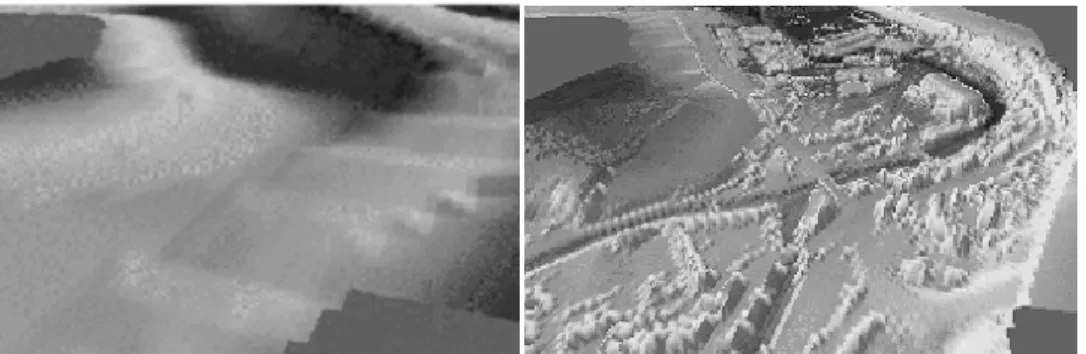
Consequently, the poor and inaccurate 3D information available for many years, 30 m of plan resolution with a precision of several meters in altitude, has been replaced by an exceptional DEM since the precision in altitude is 15 cm and the information density is one point per square meter (Fig. 1).
Figure 1. Town of Eupen: old IGN topography (left) and recent laser data (right)
Generally, specific features of flows in urban area, such as blockage by buildings, are taken into account in hydraulic numerical models by a local modification of the roughness coefficient. With the new set of topographic data, irregularities of the topography influence directly the in-undation flows. This allows focusing on proper physical values of the roughness coefficient.
3.3 Example of results
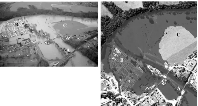
The following pictures (Fig. 2) show a comparison between the flood extension of a real event on the river Lesse and the corresponding numerical results.
The accuracy of both the DEM and the numerical model allow very precise prediction of the flood extension, even in difficult modelling situations such as bridges (A), villages (B), or flat area (C). C C A B A B
Figure 2. Lesse river - Comparison between a real flood event and the corresponding simulation
4 CONCLUSIONS
The application to flood extension forecasting of a conscientiously developed 2D numerical free surface flow solver using high resolution topography data allows obtaining reliable results on 800 km of the main rivers of the South part of Belgium. Together with the multiplicity of the re-sults available, the detailed management of the singularities in the rivers beds leads to a better understanding of the rivers functioning and of the inundation processes.
Beyond these useful results for risk analysis and land use policies, the fine grid of the simula-tion associated with the considerable elevasimula-tion precision allow very precise impact and remedia-tion studies, and the model plays thus the role of a genuine tool to help decision makers.
Resulting from several years of research and scientific development, WOLF2D is now fully operational and efficient for large scale real application thanks to the fast evolution of both cal-culation and data acquisition technologic resources.
The perspectives of improvements in the near future have to link these flow simulations with hydrologic computations of the whole river watershed to predict the flood extension from real time rain data.
REFERENCES
Archambeau, P., Dewals, B. Detrembleur, S., Erpicum, S., Pirotton, M. 2004. A set of efficient numerical tools for floodplain modeling. In Jirka G.H. & Uittewaal W.S.J. (ed.), Shallow flows. Leiden: Balke-ma
Erpicum, S., Archambeau, P., Dewals, B. Detrembleur, S., Pirotton, M. 2004. Computation of the Mal-passet dam break with a 2D conservative flow solver on multiblock structured grid. In Liong S., Phoon K. & Babovic V. (ed), Proc. of the 6th Hydroinformatics Conf. Singapore, 21-24 June 2004
Erpicum, S. 2006. Optimisation objective de paramètres en écoulements turbulents à surface libre sur
maillages multibloc, PhD Thesis. Liege : HACH, University of Liege
Mouzelard, T. 2002. Contribution à la modélisation des écoulements quasi tridimensionnels