James Bay municipality, near Chapais Translated Title: Reprint Status: Edition: Author, Subsidiary: Author Role:
Place of Publication: Québec
Publisher Name: INRS-Eau, Terre & Environnement Date of Publication: 2005
Original Publication Date: Octobre 2005 Volume Identification:
Extent of Work: xvi, 94
Packaging Method: pages incluant 3 annexes Series Editor:
Series Editor Role:
Series Title: INRS-Eau, Terre & Environnement, rapport de recherche Series Volume ID: 806
Location/URL:
ISBN: 2-89146-309-9
Notes: Rapport annuel 2005-2006
Abstract: Numéro demandé par RQuilbé le 8 juin 05, attribué par pdion le même jour. Confidentiel? non
ISBN? oui (Si on attribue un ISBN, alors il y aura dépôt légal par l'INRS-ETE).
Date de dépôt aux archives INRS-ETE prévues juin 2005. Date réellement déposée 15 décembre 2006
Rapport réalisé Oujé-Bougoumou Eenuch Association Waswanipi First Nation
Cree Board of Health and Social Services
Depot BNC et BNQ fait le 26 janvier 2007. Pas de prix
Call Number: R000806
Pig Farming in the James Bay Municipality,
near Chapais
Report to
Oujé-Bougoumou Eenuch Association
Waswanipi First Nation
Cree Board of Health and Social Services
Prepared by :
Alain N. Rousseau Ph.D., ing.
Simon Ricard ing. Jr., M.Sc.
Renaud Quilbé, D.Sc.
Centre Eau Terre et Environnement
Institut National de la Recherche Scientifique (INRS-ETE)
490 de la Couronne, Quebec (Quebec), G1K 9A9
Report N° R-806
October 2005
Alain N. Rousseau, 2005 ISBN : 2-89146-309-9
project known as the “Quebec Northern Agri-Food Project in the Production and Transformation of Natural Pork Meat” has been proposed along the Obatogamau River, 11 to 20 km south-west of the town of Chapais, in the James-Bay Municipality, on the Trapping Territory of Mr. Malcom Dixon of Waswanipi Cree Community. Representing a 75-M$ investment, the integrated pig farming project will require the construction of 43 buildings over a four-year period and will, according to the promoter, boost the local economy by creating 135 direct jobs. Once completed, the Chapais pig farm will house around 70,000 animals, which represents the largest pig farm project in Quebec. The pig slurry will be treated using the Biofertile ® technology. Biosolids will be used as either: (i) a combustible for the cogeneration plant of Chapais, (ii) a fertilizer for surrounding and remote cropland or (iii) a fertilizer for the surrounding logged areas. The treated effluent will be discharged into the Obatogamau River.
In 2002, a moratorium was established on pig farm development and a provincial-wide, public consultation was initiated to develop a sustainable framework to enhance social acceptability. In December 2004, Bill 54 was introduced in combination with a partial lifting of the moratorium, that is authorization certificates for the establishment of new pig farms were issued by the Quebec Government only in those 339 municipalities (the James-Bay Municipality being one of them), where on-farm nutrients are not exceeding crop requirements. Moreover, Bill 54 provides municipalities with new administrative powers and responsibilities, one of them being the obligation to hold public consultations to inform citizens and to define additional measures to reduce the environmental and social impact of pig farming. It is noteworthy that municipalities and public consultations do not have the legal capacity to evaluate project relevancy nor environmental impacts. Nevertheless, in accordance with directives given by the Provincial Administrator, the James Bay Northern Quebec Agreement, the conditions established in the Regulation Respecting Agricultural Operations and any relevant Municipal Bylaws, the proposed pig farming project in the James Bay Municipality, near Chapais, must be supported by an impact study
Covering most of the Northern Quebec Territory, the boreal forest is characterized by a significantly sensitive environment. In Northern Quebec landscapes and ecosystems, water quality is good and water resources are mostly used for hydroelectricity, mining and logging. Given the harsh climatic conditions characterizing the boreal region and a significant remoteness from major markets, agricultural activities are scarce. Field observations and measurements from several studies have shown that clear cutting has important short-term
impacts on streamflow, with increased annual runoff and peak flows; as well as on the quality of surface waters, with increased sediment, nutrient, dissolved organic carbon, and mercury concentrations in rivers and lakes. The latter is modulated by the extent of the watershed harvested area, and is particularly important for lakes with a high drainage ratio (small lakes and large watersheds), as in the case of the Boreal Shield Region. Consequently, there is an effect on aquatic life and, in the case of mercury, contamination all along the food chain, although there is still a lack of information about long-term impacts. Overall human pressure on the numerous lakes and large watersheds is low but water management problems exist and they are related to obsoletes, or complete lack of, sanitation infrastructures in some municipalities and to environmental impacts from the logging and mining industries.
Intensive pig farming has been associated with undesirable impacts on the environment and society. Inappropriate practices are often responsible for contaminated waters, eutrophication of aquatic ecosystems, poor soil quality, and exposure to harmful gases for workers and surrounding populations. In 2003, the BAPE Commission on pig farming development in Quebec recommended a modification of the decision process by increasing public participation. ROBERT HAMELIN & associés was contracted by Consultant LEGOFF Groupe
inc. to conduct the impact study of the pig farming project in Chapais. Using a matrix
approach, both project and environment were desegregated into components to identify potential impacts. Semi-quantitative criteria were then used to evaluate the potential impacts and mitigation measures were suggested. Basically the most important positive impact is economic. Most significant negative impacts are related to olfactory pollution and water quality. The promoters are committed to constrain as much as possible the undesirable impacts. However, due to scientific methodological limits, a certain level of subjectivity and uncertainty characterizes the impact study. Hence, social interpretation of environmental risks will depend on access to relevant information and the distribution of benefits and undesirable impacts. Namely the following elements needs to be further clarified by the promoters: (i) pig slurry management plan (biosolids and effluent); (ii) impacts of the discharge of the slaughterhouse effluent into Chapais municipal sewer system; and (iii) accountability and response measures related to environmental monitoring. Complementary analyses of geographical data related to hydrology, topography, nature of soils of the area affected by the pig farming project reinforce the idea that the targeted environment is sensitive to potential disturbances related to intensive pig farming.
SUMMARY ... III TABLE OF CONTENTS... V LIST OF FIGURES ...XI LIST OF TABLES ...XIII LIST OF ACRONYMS ...XV
1 INTRODUCTION... 1
1.1 BACKGROUND INFORMATION ...1
1.2 Scope of this report...2
1.3 organization of this report...2
2 DESCRIPTION OF THE PIG FARMING PROJECT PROPOSED BY CDEC ... 5
2.1 background information...5
2.1.1 Pig Farming in Quebec...5
2.1.2 Pig Farming Models ...5
2.1.3 History of the Proposed Pig Farming Project in Chapais ...6
2.2 CONSTRUCTION PHASE ...7 2.2.1 Location ...7 2.2.2 Preparation Works...8 2.2.3 Buildings ...8 2.2.4 Related Infrastructures...9 2.2.4.1 Water Supply ...9 2.2.4.2 Access Roads...9
2.3 OPERATIONAL PHASE... 10 2.3.1 Feeding ...11 2.3.2 Production ...11 2.3.3 Slurry Management...12 2.3.3.1 Biosolids ...12 2.3.3.2 Effluent ...13 2.3.4 Waste Management...14 2.4 Restoration phase... 14 3 LEGISLATIVE FRAMEWORK ... 15 3.1 Backgroung information ... 15 3.2 Legal requirements... 15 3.3 Bill 54... 16 3.3.1 New Requirements ...17 3.3.2 Public Consultations...17 3.3.3 Quotas ...18
4 IMPACTS OF FOREST DISTURBANCES ON WATERS OF THE BOREAL ENVIRONMENT ... 19
4.1 BACKGROUND INFORMATION... 19
4.2 Specificity of the Boreal environment... 19
4.3 impacts of logging on Water regime ... 20
4.3.1 General Concerns ...20
4.3.2 Specific Data for Boreal Shield Forest...20
4.4 impacts of logging on water quality... 21
4.4.1 General Concerns ...21
4.4.2 Specific Data for Boreal Shield Forest...21
4.4.3 Effects on Aquatic Life...23
5 CURRENT STATE OF WATER RESOURCES, WATER USES AND CONCERNS OF THE POPULATION OF NORTHERN QUEBEC...25
5.1 State of Water Resources...25
5.1.1 Surface Water ... 25
5.1.2 Ground water... 27
5.2 Water Uses...27
5.2.1 Municipal Services: Drinking Water and Wastewaters ... 27
5.2.2 Industry ... 28
5.2.3 Agriculture and Recreational Activity... 28
5.2.4 Role of Water in First Nation Life and Culture... 29
5.3 Main Concerns ...29
5.3.1 Concerns of the James Bay Development Board ... 29
5.3.2 Concerns of the BAPE Commission... 30
5.3.3 Concerns of the Cree Nation... 30
6 SUMMARY OF RESULTS AND FINDINGS OF THE BAPE CONSULTATION ON SUSTAINABLE DEVELOPMENT OF PIG FARMING IN QUEBEC...31 6.1 BACKGROUND INFORMATION ...31 6.2 Ecological Impacts ...31 6.2.1 Water ... 31 6.2.2 Soil ... 33 6.2.3 Air ... 34 6.2.4 Wildlife Habitats ... 34 6.3 Social Impacts ...35 6.3.1 Social Impacts ... 35
6.3.2 Health Risks to Workers and Surrounding Population ... 35
6.3.2.1 Risk Related to Direct Contact with Animals... 36
6.3.2.2 Risk Related to Air Quality of Pig Farm Buildings... 36
6.3.2.3 Risks of Toxic Effects on Workers ... 37
6.4 BAPE RECOMMANDATIONS...38
7 SYNTHESIS OF THE IMPACT STUDY CONDUCTED BY THE PROMOTER ... 39
7.1.1 Identification of Interrelations...39
7.1.2 Impact Analysis ...40
7.1.3 Residual Impact...40
7.2 Description of the major impacts... 41
7.2.1 Positive Impacts ...42 7.2.1.1 Economic Spin-Off...42 7.2.1.2 Soil Quality ...43 7.2.2 Negative Impacts ...43 7.2.2.1 Odours...43 7.2.2.2 Soil Quality ...44 7.2.2.3 Water Quality ...45
7.2.2.4 Vegetation and Wildlife ...45
7.2.2.5 Dust and Particles ...46
7.2.3 Ambiguous Impacts...46
7.2.3.1 Quality of Life...46
7.2.3.2 Traditional Activities...47
8 DISCUSSION OF THE IMPACT STUDY AND POTENTIAL RISKS OF PIG FARMING IN A BOREAL ENVIRONMENT...49
8.1 Background information... 49
8.1.1 The Concept of Impact Study...49
8.1.2 The Notion of Risk...50
8.2 Limits of the impact study conducted by the promoter... 52
8.2.1 Methodology...52
8.2.1.1 High Level of Subjectivity...53
8.2.1.2 Comparison with Other Pig Farming Project ...54
8.2.2 Modelling...55
8.2.3 Points to be Clarified...55
8.2.3.1 Biosolids Management Plan...55
8.2.3.2 Monitoring Measures...56
8.2.3.3 Impact on Traditional Activities...56
8.3 Ecological risks on the boreal environment... 57
8.3.1 Ecological Polygons...57
8.3.2 Water...58
8.3.2.2 Description of the Pig Farm Watershed... 60
8.3.2.3 QMDDEP Study on Water Quality in Agriculturally Intensive Regions... 62
8.3.2.4 Risks of Pig Farming on Water Quality ... 63
8.3.3 Soils... 63
8.3.3.1 Description of the Soil in the Waswanipi River Watershed ... 63
8.3.3.2 Description of the Soil in the Area Affected by the Pig Farming Project ... 64
8.3.3.3 Risk of Pig Farming on Soil Quality ... 64
8.3.4 Wildlife Habitats and Vegetation ... 65
8.3.4.1 Description of the Ecoforester Environment Within the Pig Farm Watershed... 65
9 CONCLUSION ... 67
10 REFERENCES ...71
APPENDIX A. LOCATION PLAN PROVIDED BY THE PROMOTER ... 75
APPENDIX B. COMPLEMENTARY MAPS ... 77
APPENDIX C. CLIMATIC AND HYDROLOGICAL DESCRIPTION OF WASWANIPI RIVER WATERSHED ...81
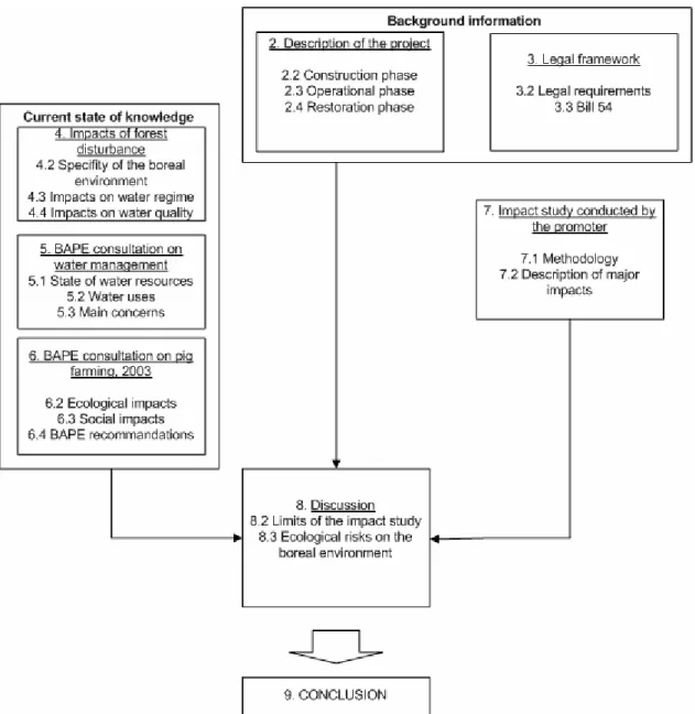
Figure 1.1 Schematic representation of the report...3
Figure 2.1 Distribution of pig livestock population in Quebec ...6
Figure 2.2 Schematic representation of the operational phase ... 10
Figure 4.1 Map of the studied region with the location of the reference, burnt and logged lakes ...22
Figure 5.1 Major watersheds in Quebec and location of the region of interest located between the 49th and the 55th parallel excluding the Saguenay - Lac-St-Jean and the North Coast regions ...26
Figure 7.1 Schematic representation of the matrix approach methodology ... 39
Figure 7.2 Projection of the potential areas of odour nuisance... 44
Figure 8.1 Risk evaluation equation ... 51
Figure 8.2 Ecological polygons for region of Chapais ... 57
Figure 8.3 Waswanipi River watershed... 59
Figure 8.4 Pig farm watershed in surroundings of Chapais... 61
Figure 8.5 Distribution of wetlands ... 62
Figure 8.6 Area covered by SIEF data... 65
Figure B.1 Municipal territories... 77
Figure B.2 Topography of the Chapais region... 78
Figure B.4 Distribution of trapping territories ...80
Figure C.1 Annual temperature distribution, Waswanipi River watershed ...81
Figure C.2 Monthly temperature distribution, Waswanipi river watershed ...82
Figure C.3 Monthly runoff distributions, Waswanipi River ...83
Figure C.4 Monthly runoff distributions, Waswanipi River ...83
Table 2.1 Infrastructure characteristics...8
Table 2.2 Livestock of the Chapais pig farming project ... 12
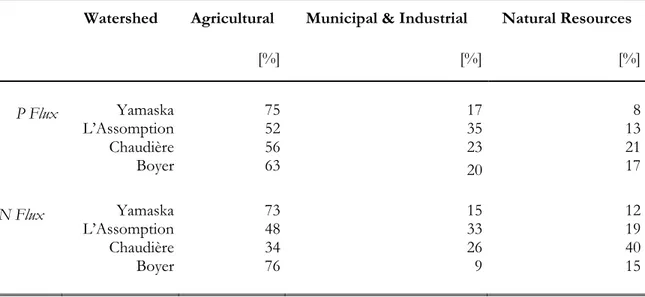
Table 6.1 Relative N and P contributions of different sectors of the economy to water pollution measured at the outlet of Quebec rivers draining agricultural land ...32
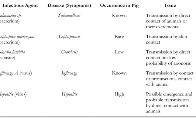
Table 6.2 Zoonosises transmitted to pig farming workers ... 36
Table 6.3 Health effects of gas in an enclosed environment... 37
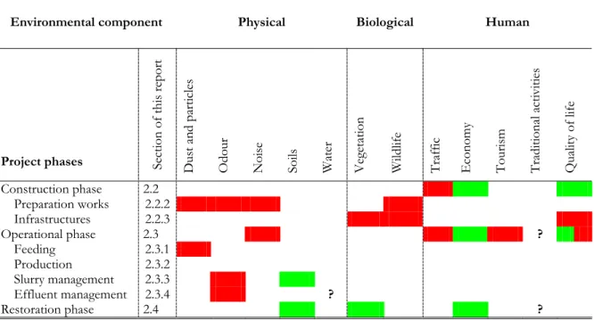
Table 7.1 Synthesized impact matrix of the pig farming project in Chapais... 41
Table 7.2 Synthesis of the most important residual impacts of the pig farming project .. 42
Table 8.1 Chart used by the promoter to evaluate residual impact value... 53
Table 8.2 Comparison of positive and negative residual impact values... 54
Table 8.3 Description of the four ecological polygons affected by the pig farming project 58 Table 8.4 Hydrological information of Wawasnipi Riverwatershed... 60
Table 8.5 Distribution of soils in Waswanipi watershed... 64
(Aliments Naturels Chapaisiens)
BAPE Environmental Public Hearings Office
(Bureau d'audiences publiques sur l'environnement)
BOD Biological oxygen demand
CDEC Economic Development Committee of Chapais
(Comité de développement économique de Chapais)
COMEV Evaluation Committee of QMDDEP COMEX Expert Committee of QMDDEP
CREAQ Quebec Economical References in Agriculture Committee
(Comité de références économiques en agriculture du Québec)
DOC Dissolved organic carbon
QFAPA Quebec Society for Wildlife and Parks
(Société de la faune et des parcs du Quebec)
FMQ Quebec Municipalities Federation
(Fédération Québecoise des Municiplités)
JBDB James Bay Development Board
JBNQA James Bay Northern Quebec Agreement
HQ Hydro Quebec
(Hydro-Québec)
LAU Land Use Planning and Development Law
(Loi sur l’aménagement et l’urbanisme)
LPTAA Preservation of Agricultural Land and Activities Protection Law
(Loi sur la protection du territoire et des activités agricoles)
QMAMSL Quebec Ministry of Municipal Affairs, Sports and Leisure
(Ministère des Affaires municipales, Sports et Loisirs)
(Ministère de l’Agriculture, Pêcheries et Alimentation)
QMRNFP Quebec Ministry of Natural Resources, Wildlife and Parks
(Ministère des Ressources naturelles, de la Faune et des Parcs)
MRC County Regional Municipality
(Municipalité Régionale de Comté)
OAQ Quebec Order of Agronomists
(Ordre des Agronomes du Québec )
OECD Organisation for Economic Co-operation and Development
QMDDEP Quebec Ministry of Sustainable Development, Environment and Parks
(Ministère du Développement durable, de l'Environnement et des Parcs)
RAQ Regulation Respecting the Quality of the Atmosphere
(Règlement sur la qualité de l’atmosphère)
REA Regulation Respecting Agricultural Operations
(Règlement sur les exploitations agricoles)
SIEF Ecoforester Information System
1.1 BACKGROUND INFORMATION
The boreal forest of Canada accounts for about 40% of the world’s boreal forest, with a larger proportion of virgin forest than any other country. The forests, interlaced with large rivers, lakes and wetlands, provide habitats for large numbers of mammals and birds. The coniferous tree species of the boreal forest have excellent properties for paper production, dimensional lumber and plywood or other panelling, which accounts for approximately 60% of the Canadian economic activity in forest products [Burton et al., 2003]. Other commercial uses of the boreal forest have been mostly concentrated around mining and hydroelectricity.
Harsh climate conditions, natural cycles of disturbances and successions of wildfire or insect outbreaks, and poor soil conditions have discouraged significant agricultural development and human settlement. Through millenia, boreal forests have been home to Indigenous people who live off the land by fishing and hunting, and who are increasingly participating in local economic development such as commercial forestry and eco-tourism. Non-native settlements are few and located around current and old mining sites, saw mills, and hydroelectric power plants. In all settlements, agricultural production is marginal since the boreal environment is established on glacial till or the land is characterized by shallow-soils and infertile uplands alternating with wetlands and poorly drained organic soils with significant nitrogen limitations to plant productivity [Burton et al., 2003].
In 2000, the Corporation de Développement Économique de Chapais (CDEC) initiated the Northern Quebec Agri-Food Project to Produce and Process Natural Pork Meat (Projet Agro-Alimentaire
du Nord Québécois en Production et en Transformation de Viande de Porc Naturel) in the James Bay
Municipality, near Chapais, Quebec. On behalf of the CDEC, Consultant LEGOFF Groupe inc. 1 recently completed an impact study in accordance to the COMEV directive with respect to Section 22 of James Bay Northern Quebec Agreement (JBNQA), the Regulation Respecting Agricultural Operations (REA), and any relevant Municipal Bylaws.
1
1.2 SCOPE OF THIS REPORT
Considering the remoteness from major markets, it is somewhat surprising that a promoter is planning a large-scale, pig farming project within a northern boreal environment. On behalf of the Council of the Oujé-Bougoumou Cree Nation, the Waswanipi First Nation and the Cree Board of Health and Social Services, this report presents a study on the current understanding of potential environmental and social risks of pig farming in the James Bay Municipality, near the non-native town of Chapais. This study will be used as a discussion paper and will form the basis for a presentation at the upcoming public consultation on the project.
1.3 ORGANIZATION OF THIS REPORT
This report is organized into six Sections corresponding to Chapters Two through Eight. Figure 1.1 presents a schematic representation of the report’s structure.
• Chapter Two describes the large-scale pig farming project proposed by the CDEC. • Chapter Three presents an up-to-date summary of jurisdictional considerations
related to pig farming development in Quebec.
• Chapter Four summarizes the current state of knowledge of the impacts of forest disturbances, such as clear cutting, on surface waters of the boreal environment of Canada.
• Chapter Five describes the water management portrait of Northern Quebec as reported in 2000 in the proceedings of the public consultation on water management in Quebec conducted by the BAPE (Bureau d’audience publique du Québec).
• Chapter Six presents a summary of relevant results and findings of the BAPE’s public consultation on sustainable development of pig farming in Quebec, that is the environmental (water, soil, air, wildlife habitats) and social impacts (social climate, health risks to workers and surrounding population).
• Chapter Seven describes the findings of the impact study conducted by the promoter as provided for in the JBNQA.
• Chapter Eight discusses the impact study produced by the promoter and analyzes complementary information and data in terms of the ensuing ecological risks caused by the future implementation of the pig farming project.
2.1 BACKGROUND INFORMATION
2.1.1 Pig Farming in Quebec
Until the 1970s, pig production in Quebec was characterized by a relatively constant and slow growth (roughly 2% per year since 1920). Then, production suddenly exploded and the growth rate reached 20% annually between 1976 and 1981 (overall, a total growth of 325%). With a total livestock population of 4.3 million pigs, 1.13 billion dollars in sales receipts, and 28,000 workers (2001), pig farming now represents the second largest agricultural activity in Quebec, right behind dairy farming. This rapid evolution, combined with the pressure of demand-driven market liberalisation, forced Quebec’s pig producers to quickly adapt their production methods to focus on productivity, industrialization and specialisation. This resulted in the intensification of pig production (more pigs produced by less farms) with an average size of 1,556 pigs per enterprise (compared to 79.4 in 1971). The agricultural production areas are mainly located in central Quebec where feed is easily accessible. Figure 2.1 presents the distribution of the total pig livestock population in Quebec. Three quarters of pig farms are located in Montérégie, Chaudière-Appalache and Centre du Quebec. With only four specialized pig farms (the average in Quebec being 157 per administrative region), the Abitibi-Témiscamingue region is the second smallest pig producing region.
2.1.2 Pig Farming Models
According to the BAPE Commission on pig farming development in Quebec [BAPE, 2003], it is hard to characterize pig farming, but specific, non-exclusive, elements can be used:
(i) Producer’s status, that is, either autonomous or integrated. In the first case, the producer owns all goods required for pig production: land, infrastructures and animals, allowing producers to freely select suppliers. An integrated producer acts mostly as a manager on behalf of others. While the producer has the land and the infrastructures, the integrated producer provides the animals and all the other inputs. The integrated producer is generally in charge of marketing.
(ii) Relationship with the land, that is, a producer either owns cropland, or not.
(iii) Specialization status, that is, the producer is either involved in all production steps (from birth to finishing), or in a few steps.
Figure 2.1 Distribution of pig livestock population in Quebec ([BAPE, 2003], volume I,
p. 67, adapted from PROD93)
2.1.3 History of the Proposed Pig Farming Project in Chapais
Since the closing down of the Opemisca Mine in 1998, the economic situation has significantly worsened in the Chapais Region. Facing a high unemployment rate (up to 17% at Chapais) and an exodus of the labour force, the un-diversified local economy mostly depends on forest exploitation (timber). Created in 2000 and led by Mr. Jacques Bérubé, Mayor of Chapais, the CDEC is an organisation promoting development of the regional economy2. Focusing on economic benefits, the CDEC proposed a project known as the “Quebec Northern Agri-Food Project in the Production and Transformation of Natural Pork Meat”, an initiative of the
Groupe Les Aliments Naturels Chapaisiens Inc. (a.k.a., Goupe A.N.C. Group). Over ten years, the
CDEC and the Consultant LEGOFF Groupe inc.3 and Viandes Kamouraska Packers inc. are planning to invest 75M$, creating 300 direct and permanent job opportunities.
2 More information on the CDEC’s projects and development strategies can be found on Ville de Chapais’s website: www.villedechapais.com/developecono.htm.
3
Construction of the complex is planned over a four-year period and is characterized by an integrated approach to the operation, which, according to the promoters, will ease the management and monitoring procedures. Once completed, the agricultural complex will hold around 70,000 animals (sows, weaned piglets and pigs), much larger than the average pig farm in Québec (1,556 animals).
For now, Consultant LEGOFF Groupe inc. and Viandes Kamouraska Packers inc. are the only identified promoters of the project with regard to investment, professional training, operations, slaughtering, transformation and marketing. Consultant LEGOFF Groupe inc. completed in February 2005 a study on the potential environmental impacts of the project [Consultants LEGOFF Groupe inc., 2005]. The study presents exhaustive information related to the project phases, the environment, public concerns, potential impacts and attenuation measures. The following sections present a brief description of the pig farming project while evaluation of the environmental impacts will be discussed in Chapter 7.
2.2 CONSTRUCTION PHASE
2.2.1 Location
According to the promoters, the project will be located on Category III Public Lands, mostly forested. Breeding sites will be located on a land strip roughly located along the Obatogamau river South-West of Chapais (11 and 20 km, see Appendix A), corresponding to the centre of W-23 Trapping Territory of Mr. Malcom Dixon of Waswanipi Cree Community. The major selection criteria for this location, as justified by the promoters, are:
(i) potential spacing between buildings offers increased sanitation security;
(ii) strategic location regarding prevailing winds reduces the spreading of odours towards the city; and
(iii) current road access4.
Other buildings include a grain storage facility, a feed mill, an administration office, and a garage on the South-West outskirt of Chapais. A slaughterhouse will be located in the city’s industrial park.
2.2.2 Preparation Works
Clearing works (tree cutting, branch burning, stump extraction and grading) will need to be done before undertaking the construction of the main infrastructures. According to the promoters, the total cleared area is estimated at 32 ha.
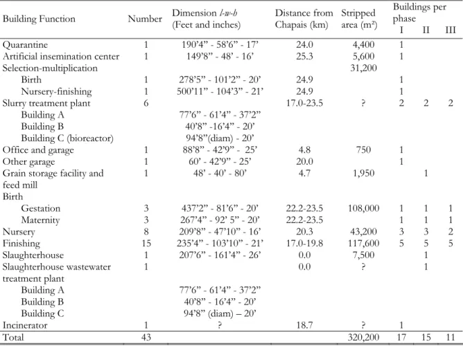
2.2.3 Buildings
The construction of the pig farm infrastructures will take place over a four-year period in three major phases (Phases I, II, III). Table 2.1 chronologically summarizes the description and functions of the buildings. The specific location of each item is presented in Appendix A.
Table 2.1 Infrastructure characteristics
Buildings per phase Building Function Number Dimension l-w-h (Feet and inches) Distance from Chapais (km) Stripped area (m²)
I II III Quarantine 1 190’4’’ - 58’6’’ - 17’ 24.0 4,400 1
Artificial insemination center 1 149’8’’ - 48’ - 16’ 25.3 5,600 1
Selection-multiplication
Birth 1 278’5’’ - 101’2’’ - 20’ 24.9 1
Nursery-finishing 1 500’11’’ - 104’3’’ - 21’ 24.9
31,200
1
Slurry treatment plant 6 17.0-23.5 ? 2 2 2
Building A 77’6’’ - 61’4’’ - 37’2’’ Building B 40’8’’ -16’4’’ - 20’ Building C (bioreactor) 94’8’’(diam) - 20’
Office and garage 1 88’8’’ - 42’9’’ - 25’ 4.8 1
Other garage 1 60’ - 42’9’’ - 25’ 20.0 750 1
Grain storage facility and
feed mill 1 48’ - 40’ - 80’ 4.7 1,950 1 Birth Gestation 3 437’2’’ - 81’6’’ - 20’ 22.2-23.5 108,000 1 1 1 Maternity 3 267’4’’ - 92’ 5’’ - 20’ 22.2-23.5 1 1 1 Nursery 8 209’8’’ - 47’10’’ - 16’ 20.3 43,200 3 3 2 Finishing 15 235’4’’ - 103’10’’ - 21’ 17.0-19.8 117,600 5 5 5 Slaughterhouse 1 207’6’’ - 161’4’’ - 26’ 0.0 7,500 1 Slaughterhouse wastewater treatment plant 1 0.0 ? 1 Building A 77’6’’ - 61’4’’ - 37’2’’ Building B 40’8’’ - 16’4’’ - 20’ Building C 94’8’’ (diam) – 20’ Incinerator 1 ? 18.7 ? 1 Total 43 320,200 17 15 11
Detailed information related to construction techniques and building site organization is available in the environmental analysis conducted by Consultants LEGOFF Groupe inc. [2005; pages 29 to 65].
2.2.4 Related Infrastructures 2.2.4.1 Water Supply
Water will be supplied by artesian wells at each site or in surrounding eskers. The construction of reservoirs will provide a 24-hour water supply. In October 2004, a brief analysis was conducted to evaluate ground water yields. Results showed a pumping capacity of 10 to 45 gallons per minute. The minimum required yield to meet livestock needs is 10 gallons per minute. The promoters will conduct a more in-depth analysis if the project gets final approval.
2.2.4.2 Access Roads
An enlargement of the current gravel road (see Appendix A) is required over a 5.2 km stretch. An equivalent distance is needed for the construction of access roads leading to all buildings.
2.2.4.3 Protection against Fire
In case of fire at the breeding sites, ten firemen and one fire truck would be available in Chapais. Moreover, implementing a sprinkler system is not an option because of the quantity of water required. Thus, to ensure protection against fire spreading in the surrounding areas, the promoters will implement security measures such as:
(i) annual fire fighting training of some workers;
(ii) construction of two 750-m³ water dugouts close to the birth and finishing sites; (iii) ensure the permanent presence of fire trucks (bought by the promoters) close to
finishing sites and the main access road; and
(iv) creation of a 30-m fire barrier and a 20-m buffer zone5.
5Quebec Ministry of Natural Resources, Wildlife and Parks (QMRNFP) required a 10-m fire barrier and a 20-m buffer zone.
2.3 OPERATIONAL PHASE
The operational phase refers to actual activities involved in pig farming. Figure 2.2 illustrates the processes related to this specific phase and synthesizes the complex interrelations of the livestock production cycle. Four major steps are described below: feeding (2.3.1), production (2.3.2), slurry management (2.3.3) and waste management (2.3.4).
Figure 2.2 Schematic representation of the operational phase ([Consultants LEGOFF
2.3.1 Feeding
The first step of the operational phase is supplying grain and other raw materials to the feed mill. For the producer, the diet is a key factor to cost effectiveness, representing up to 75% of the variable costs of the enterprise. The ration composition is based on energy (corn, barley, wheat, oat), protein (soy oil cakes and peas) and minerals, salts and other supplements. It allows for a controlled administration of food and medication to the animals depending on gender, weight, age and genetic considerations. According to the promoters, for a few days, medication will be added to the rations of weaned piglets.
The grains will be transported from surrounding crop production areas (e.g. Saguenay, Lac Saint-Jean, Abitibi, Southern Quebec) to the feed mill by train or truck. To ensure a certain level of sanitary control, the area around the grain storages will be cleaned and extermination measures will be undertaken in the area surrounding the mill and buildings. The total annual feed supplied is estimated at 43,503 tons per year, a daily supply of eleven 15-ton trucks.
2.3.2 Production
The production step refers to livestock development. It involves a complex “animal migration scheme” from one building to another, depending on growth stage. Production management in a large pig farming project is increasingly supported by software where energy optimization and genetic control are key factors. Two livestock groups, each one evolving along different production paths, exist: multi-reproduction livestock and commercial livestock.
Multi-reproduction livestock is composed of gilts and boars for reproduction. Gilts start out at the multiplication site, while the boars wait at the insemination site. Once inseminated and after approximately 100 days of gestation, mature sows are relocated to the birth site. The sows will have up to 13 piglets (destined for the commercial livestock facility upon weaning). While developing the multi-reproduction livestock, measures are necessary to prevent contamination and to ensure a good genetic reproduction.
The commercial livestock is composed of piglets available for slaughtering and transformation into meat products. After 21 days of suckling in parturition cages, weaned piglets are transferred to the nursery site where they will grow up to 20 kg (about 45 days). Afterwards, they will spend 100-120 days in the finishing site (up to 115 kg).
Gilts and boars not required for reproduction, as well as, mature pigs from the commercial livestock facility, are taken to the slaughterhouse to be slaughtered, transformed (chopped, wrapped and frozen) and transported by refrigerated trucks to distribution centres (mostly Montréal).
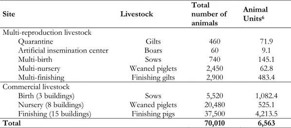
Table 2.2 gives quantitative details on both multi-reproduction livestock and commercial livestock. The total number of animals in the Chapais pig farming project is estimated at 70,010 animal (equivalent to 6,563 animal units). According to Brouillet [2005], the proposed size will be the largest pig farming project in Quebec.
2.3.3 Slurry Management 2.3.3.1 Biosolids
A slurry treatment process called Biofertile®, designed by Envirograin and authorized by the Quebec Ministry of Sustainable Development, Environment and Parks (QMDDEP), will be implemented at all six treatment plants and the slaughterhouse. Thus, the bisolids of the feces and slaughterhouse sewage will be filtered and dehydrated to produce a valuable and reusable material for agriculture. According to Envirograin, this process provides the following benefits: low production cost, less odour, reduced volume, and good agronomic value.
Table 2.2 Livestock of the Chapais pig farming project
Site Livestock Total number of
animals
Animal Units6
Multi-reproduction livestock
Quarantine Gilts 460 71.9
Artificial insemination center Boars 60 9.1
Multi-birth Sows 740 145.1
Multi-nursery Weaned piglets 2,450 62.8
Multi-finishing Finishing gilts 2,900 483.4
Commercial livestock
Birth (3 buildings) Sows 5,520 1,082.4
Nursery (8 buildings) Weaned piglets 20,480 525.1 Finishing (15 buildings) Finishing pigs 37,500 4,213.5
Total 70,010 6,563
Source: [Consultants LEGOFF Groupe inc., 2005], p.47.
On a daily basis, 50 m³ of biosolids, containing 25% dry matter, will be produced. A telemetric system will remotely control all operations, allowing rapid intervention and continuous monitoring. Samples will be taken and analyzed every other week. In case of breakdowns, the treatment system will have a 35-day retention capacity.
Three options are being considered for valuing the biosolids:
(i) Biosolids could be used as fuel compounds for the Chapais cogeneration plant. This option would reduce odour production by avoiding biosolid stockpiling. This operation requires transportation of significant quantities of biosolids to Chapais. However, the technical and environmental feasibility of this option has not yet been demonstrated. (ii) Given the limited cropland in the Chapais region, it is impossible to locally
agronomically value all biosolids produced by the pig farming complex unless new agricultural projects are undertaken. Drying and transporting of biosolids to remote agricultural regions would be expensive for the promoters.
(iii) Biosolids could also be used to fertilize the neighbouring logged area left by the Chapais-Barette timber harvesting activities, upgrading harvesting efficiency and improving soil quality. As for option (i), no methodology has been approved.
2.3.3.2 Effluent
The Biofertile® technology allows for the separation of slurry into biosolids and liquids - valuing the effluent represents a great challenge. Considering the poor drainage properties of the soil, the option considered by the promoters is the treatment and the discharge of the effluent into surface waters. The pig farming complex is expected to produce 500 m³/day of effluent – 350 m³/day, after biological and electrochemical treatments (described below) at the six treatment plants, and 140 m³/day from slaughterhouse. Effluent discharge requires an authorization of the QMDDEP.
Once separated form the slurry, the effluent will be directed into a decantation basin where it will undergo three treatment processes. First, aerobic, biological treatment will take place to capture organic nitrogen and get rid of ammonia-nitrogen. This process produces gas nitrogen (N2), a non-toxic and non-greenhouse effect gas. A second advanced biological process (FLAIR®) will provide for a refined water filtration as well as an air filtration, reducing odour spreading. A final electrochemical polishing treatment (POLIPUR®, patent pending) will catalyze the decantation of residual phosphorus, suspended matter and pathogenic microorganisms. All solid decanted residues will be combined with the biosolids.
Part of the treated effluent will be reused for washing the gutters, the rest will be discharged into the Obatogamau River (from the treatment plants) and into Chapais’ municipal sewer system (from the slaughterhouse). To avoid damage from freezing and thawing, underground pipelines will be installed at the treatment plants and along the river bank. Ground water quality will be monitored using piezometers located around the treatment plants and the other buildings.
2.3.4 Waste Management
Wastes at the slaughterhouse include animal carcasses, placentas, fat and blood. On an annual basis, 135,200 pigs will be slaughtered representing 3,380 tons of organic matter. Most organic wastes will be directly shipped to an incinerator (morgue, incinerators and ash storage facilities) located close to the finishing centres (kilometre 18.7, see Appendix A). Fourteen incinerators (burning capacity of 75 kg/hour) will operate up to 12 hours a day, five days a week. The amount of ashes produced annually is estimated at 125 tons (more or less 1 m³/week). Ashes will be stockpiled in a horizontal storage facility (260-m³ capacity) and will be shipped to a dump site 20 km from Chapais. Greases and blood are by-products of pig slaughtering that can be valued. To extract grease and blood, note that a biological treatment, similar to Biofertile®, can be applied to the slaughterhouse wastewater.
2.4 RESTORATION PHASE
After cleaning and demolishing the buildings, part of residual materials will be recycled or transported at a local dumpsite. Potentially contaminated soils will be removed and restoration work will be implemented over areas where the buildings were. The promoters are committed to invest in a restoration fund, ten years after beginning operation, equivalent to 10% of the estimated restoration costs.
3.1 BACKGROUNG INFORMATION
Quebec laws with regard to pig farming are characterized by a parallel evolution of two regimes. Both introduced in the late seventies, the Preservation of Agricultural Land and Activities Protection Law (Loi sur la protection du territoire et des activités agricoles – LPTAA) and the Land Use Planning and Development Law (Loi sur l’aménagement et l’urbanisme – LAU) established a complex jurisdictional system of overlapping administrative powers. Since then, many attempts have been made to harmonize these laws, introducing principles favouring producers such as the lawsuit immunity of 1989 and the agricultural activities protection of 1997. Nevertheless, observing the tensed debate regarding to pig farm establishment, one can conclude that there is a lack of agreement and an increase in political tension, due to a rigid jurisdictional framework, insufficient information being conveyed to the public, and a lack of transparency in the whole decision process [BAPE, 2003].
In June 2002, the pig farming restriction Law (Loi sur la restriction de l’élevage des porcs – L.Q. 2002, c.18) imposed a moratorium on the development of pig farming in Quebec. The REA [MENV, 2003a,b; Gazette Officielle du Quebec, 2004] [a.k.a., Règlement sur les exploitations
agricoles (REA)] was enforced, right away mandating the BAPE (see Chapter 6) to define a
sustainable development framework for pig farming in Quebec, that takes into account environmental, social and economical issues. The BAPE report on pig farming was released in 2003 [BAPE, 2003], with one of the main recommendation being: “[…] the implementation of an environmental and social impacts analysis process involving public participation […].”
3.2 LEGAL REQUIREMENTS
The CDEC, for the ANC. Group, mandated Consultants LEGOFF Groupe inc. to conduct the impact study7 in accordance with the directive given by the Provincial Administrator [COMEV, 2003]. The directive defines the nature, extent and scope of the environmental and social impact study that the developer must carry out, as provided for in the JBNQA. The directive must consider the following guidelines of Section 22, specifically [COMEV, 2003]: (i) reduction of the impact of development activities on the Native people and their territory; (ii) protection of the Native people, their societies, communities, and economy from
development activities affecting their territory; (iii) protection of wildlife resources, physical and biological environment, and ecosystems, from development activities affecting their territory; (iv) respect the rights and interests, whatever they may be, of non-Aboriginal people; and (v) respect the right to proceed with development, a right that individuals acting lawfully on the territory have.
The impact study required by the Provincial Administrator [COMEV, 2003] must describe characteristics of the project and explain the purpose, taking into account the environment in which the project will take place and how this environment will be affected during the construction phase of the project, as well as during full operation. This exercise provides the basis for examining alternative means and their impacts on the environment while minimizing or eliminating any negative impacts on the environment, the resources, and the quality of life of the individuals and communities. The impact study must also propose monitoring and follow-up programs to comply with government requirements and the proponent’s commitments as well as follow the dynamics of specific components of the environment affected by the project.
In addition, the proposed pig-farming project must abide by:
(i) conditions established in the REA, particularly that livestock waste is subject to complete treatment - this means that the waste must be transformed into solid matter of a different nature (i.e., fertilizing granules or mature compost), whereby the bacteria contained therein are destroyed;
(ii) Municipal Bylaws respecting minimal distances between livestock buildings as well as spreading activities on cropland and urban areas as well as single housings in rural areas.
3.3 BILL 54
The Act to amend various legislative provisions concerning municipal affairs (Bill 54) came into effect in November 2004, modifying the LAU8 and partially removing the moratorium on pig farming development imposed in 2002. In municipalities characterized by the production of farm nutrients in excess of crop requirements (overall 228 municipalities), only expansion is allowed in compliance with specific conditions. In the other 339 municipalities, all new pig farming projects are able to get authorization certificates by QMDDEP.
MRCs (Municipalité Régionale de Comté or County Regional Municipality) are provided with more legislative flexibility with respect to zoning of livestock operations, minimal separating distances, and protection of woodlots, riparian zones, and sensitive areas. The Quebec Government partially tightened application of various environmental laws and regulations before the moratorium on pig farming was removed on December 15, 2004.
3.3.1 New Requirements
New Municipal Bylaws, as stated in Bill 54, namely municipalities [FQM, 2004], are required or have the right to:
(i) hold a public consultation before expansion or establishment of certain pig production facilities;
(ii) impose supplemental requirements; and
(iii) regulate and set quotas for pig production in their territory.
All projects of expansion or establishment of pig production facilities proposed to a municipality must be supported by several documents including: a nutrient management plan signed by a member of the Quebec Order of Agronomists (OAQ, Ordre des Agronomes du
Quebec), fertilization rates on each cropland, spreading activities including application
techniques, proposed application dates, names of municipalities where applications will take place and annual production of P2O5 should all be specified in the plan.
3.3.2 Public Consultations
According to Bill 54, a public consultation must take place prior to the emission of a construction permit by a municipality and within 30 days following transmission of the aforementioned QMDDEP authorization certificate to the municipality. The objectives related to such a process are to:
(i) provide information to concerned citizens; (ii) answer their questions;
(iii) hear their concerns; and
(iv) elaborate mitigation concerns.
“[…] the public consultation is not an opportunity to judge the relevancy of authorizing or not the project, neither to weigh up the impacts on environment as all unacceptable projects, with regards to municipal or QMDDEP rules, will have already been rejected.9”
The Mayor acts as the president of the commission/council in charge of the public consultation. Two members of the municipal council, the promoter or project spoke person, as well as representatives of the QMAPA (Quebec Ministry of Agriculture, Fisheries and Food,
Ministère de l’Agriculture, des Pêcheries et de l’Alimentation), QMDDEP, and the regional director of
Public Health. During the public consultation, members of the commission will be there to hear and answer any citizens or group of citizens who have decided to voice their concerns with the pig farming project. Within 30 days following the end of the public consultation, the commission will publish a report including specific recommendations and supplemental requirements for the emission of a construction permit. The consultation may be held by a MRC if the municipality wants, however, it is the municipality that is responsible for the supplemental requirements attached to the construction permit (e.g., construction of a roof over a slurry storage tank to reduce emission of odours, soil incorporation of slurry within 24 hours following spreading activities, minimal separating distances, rows of trees acting as odour screen, water saving equipment). In cases where the promoter disagrees with the list of supplemental requirements, a conciliator will be appointed by the QMAMSL (Quebec Ministry of Municipal Affairs, Sports and Leisure, Ministère des Affaires Municipales, Sports et Loisirs). The conciliator will report the discussion results within 30 days of his/her appointment. However, the final list of requirements will be issued by the municipality.
3.3.3 Quotas
Since June 2002, municipalities have the power to regulate and set quotas for pig production in their territory. This may be done by delineating production zones in terms of a maximum number of identical or similar pig farm production facilities, minimal distances between these facilities, and maximal floor surfaces or land areas for breeding and rearing activities. This power may also be granted to MRCs through interim control regulation that will be or have been accounted for in the MRC land-use planning. In fact, it is the recommended framework to face any expansion or establishment project of certain pig production facilities that could be granted a QMDDEP authorization certificate following the lifting of the moratorium. Once there is a new MRC land-use planning, a local municipality may then invoke the new quotas for pig production in their territory.
4.1 BACKGROUND INFORMATION
The implementation of a large-scale, pig farm project in the boreal environment will probably result in some direct deforestation (estimated at 32 ha by the promoters). Moreover, as it is the case in regions of southern Quebec with intensive pig production, additional or new cropland may be necessary for the disposal of pig slurry as an organic fertilizer. This will probably lead to further deforestation in order to develop agriculture where soil conditions may or may not be favourable.
Forest exploitation has several impacts/effects on river morphology, streamflow, water quality and aquatic ecosystems. The nature and extent of these impacts depend on climate, geology, topography as well as forest structure and composition. Boreal forests are fragile ecosystems with a slow dynamic and any disturbance such as wildfire and logging can have strong adverse effects on these ecosystems, taking time to recover from. However, there is very little data about these effects. Most studies on the impact of wildfire and logging in the Canadian boreal forest are concerned with ecosystems, wildlife and soils. Very little information related to water quality has been collected at the watershed scale.
4.2 SPECIFICITY OF THE BOREAL ENVIRONMENT
Canadian boreal forests are divided into six subregions based on geological and climatic characteristics. This section reports on the subregion of interest, the Boreal Shield of central and eastern Canada.
An important specificity of Northern Boreal Shield is the presence of wetlands, which cover about 10% of the landscape. Surface waters are located on bedrock covered by thin glacial deposits. Most lakes are small (0.15 – 0.81 km²) and shallow. The hard rock formation (granite, basalt) of the Boreal Shield makes the soil less sensitive to erosion than in sedimentary landscapes. Consequently, fewer nutrients are transported via runoff and surface water is more diluted than elsewhere, such as the Boreal Plain. Lakes are mostly oligotrophic and acidic. Algal communities are dominated by flagellated algae, like small chrysophytes, diatoms, dinoflagellates, and cryptophytes.
A study which investigated 47 undisturbed lakes and their watersheds in northern Quebec showed that nutrient concentrations, water clarity and greenness are mainly controlled by drainage ratio (watershed area divided by lake volume) and watershed slope, which implies that lakes of large and flat watersheds are richer in nutrients and ions than those of small watersheds, and may be more susceptible to enrichment from watershed disturbances [Carignan et al., 2000].
4.3 IMPACTS OF LOGGING ON WATER REGIME
4.3.1 General Concerns
With regard to the hydrological regime, deforestation systematically induces an increase in annual runoff, with a direct link between the proportion of the area being clear cut and the change in annual runoff [Plamondon, 1993]. This effect is changes with the time of the year; the increase is greater in summer because of the drastic reduction of evapotranspiration after clear cutting and the resulting change in water balance. Data from Ontario and New Brunswick showed increases varying between 100% and 200% of summer base flow [Ordre des ingénieurs forestiers du Quebec, 1996]. The main consequence of deforestation is an increase of low water peak flows [Beschta et al., 2000; Caissie et al., 2002 in Lavigne et al., 2004]. This increase in water discharge dynamics has consequences on river morphology, notably by modifying erosion processes. These effects can be modulated by the proportion of forest harvested and, in a lesser extent, the presence of buffer strips. A literature review by Plamondon [2004] showed that the cut area must exceed 50% of the watershed to have an effect on peak flow that can alter aquatic habitat.
4.3.2 Specific Data for Boreal Shield Forest
The effects of clear cutting on runoff and streamflow are roughly the same in Boreal forest as in mixed forest of southern Canada. Several studies have confirmed this using field data. For Plamondon [1993], the increase of annual runoff after clear cutting varied between 15% when annual precipitation exceeds 1,400 mm, and 50% when annual precipitation is lower than 900 mm. This increase was found to be as high as 300% for Nicolson et al. [1982].
4.4 IMPACTS OF LOGGING ON WATER QUALITY
4.4.1 General Concerns
Many studies in North American forests have shown that the impacts of deforestation on several water quality parameters may include:
• Increased mean temperature and the difference between minimal and maximal temperatures [Feller, 1981]. This applies to rivers rather than lakes [Plamondon, 1993]. • Increased water acidity.
• Increased sediment concentration due to water erosion on bare soil, as well as erosion of river banks and river bed.
• Decreased dissolved oxygen, linked with an increase in biological oxygen demand (BOD) and temperature.
• Increased dissolved organic carbon (DOC), coming from forest organic soils and carried by runoff and erosion. This is accompanied by an increase in turbidity.
• Increased nutrient (N and P) concentrations that are no longer being utilized by trees and are, therefore, available for transport via runoff and erosion. Consequently, conditions favourable to eutrophication of rivers and lakes are enhanced. It should be noted that this contamination might also affect ground water, especially for nitrates - it has been shown that nitrate concentrations in ground water could undergo a 200 fold increase after cutting [Sollins and McCorison, 1981].
• Increased mineral ions such as calcium (Ca2+), sulphur (S4+), magnesium (Mg2+), potassium (K+), sodium (Na+), iron (Fe2+) and mercury (Hg+), which become more mobile due to the absence of vegetation.
4.4.2 Specific Data for Boreal Shield Forest
Most of the information introduced in this section comes from Prepas et al. [2003]. These authors analyzed available data about the effects of watershed disturbances (logging and wildfires) in the Canadian boreal forest. This data mainly concerns lakes. In the context of this study, the focus will be on changes due to logging rather than wildfires.
Figure 4.1 Map of the studied region with the location of the reference, burnt and logged
lakes [Carignan et al., 2000].
Three upland-dominated lakes in northwestern Ontario were investigated five years before and three years after harvesting 65% of watershed forest (CLEW project, Steedman [2000], Steedman and Kushneriuk [2000]). Clear cutting induced a small increase (5% or less) in mid-lake wind speed and a decline of water clarity of 25% after three years. One year after logging, concentrations of chlorophyll, total N, K+, Cl- and Si had increased as much as 40% over predisturbance levels, while Ca2+ and Mg2+ declined by 25%. No effect was measured on greenness in lake water as well as on adult trout habitat. However, an increase in DOC was observed after high precipitation.
In northern Quebec, impacts of wildfire and logging on lake water quality and biota were also evaluated in 22 lakes located in Haute-Mauricie, near the Gouin Reservoir (see Figure 4.1). The experimental sites are not far from Chapais, in the same geological and biogeographic region, making the results transposable to the watersheds that would be disturbed by the project.
Clear cutting involved 40% of the watershed and 20-m wide buffer strips were left along lake shorelines, permanent streams, and wetlands. The results showed a strong increase in total P (up to three fold larger), total organic N (two fold larger), dissolved organic carbon (DOC, up to three fold larger), K+ and Cl- (up to six fold larger) as compared to similar reference lakes on
undisturbed watersheds [Carignan et al., 2000]. The effect on DOC, which was confirmed by Pinel-Alloul et al. [2002], persisted over three years of measurements following the clearing. This consequently limits photosynthesis in lake water and explains why no significant increase in greenness was observed despite the large increase in nutrient concentration [Planas et al., 2000]. Only some algae species (cryptophytes, chrysophytes) increased. Moreover, a 43% reduction in grazer (calanoid copepods) population, as well as small yellow perch and white sucker populations, was observed [Patoine et al., 2000; St-Onge and Magnan, 2000]. Finally, a strong increase in mercury concentrations was also observed. This contaminates the aquatic biota via bioaccumulation and biomagnifications through the food chain, and concentrations almost two fold larger were found in northern pike, reaching values above the World Health Organization safe consumption limit [Garcia and Carignan, 2000].
These changes were related to the extent of clear cutting and drainage ratio (watershed area divided by lake volume). Some studies showed that clear cutting could affect lake water quality if more than 30% of the watershed is harvested [Carignan et al., 2000]. This is an average value as some impacts were observed in shallow lakes (maximum depth less than 5 m) when less than 30% of the watershed was disturbed. The drainage ratio is a key indicator of the sensitivity of surface water to watershed disturbance, a high ratio indicating high sensitivity. Impacts of forest disturbance on water quality are more detectable when the drainage ratio of the lake is larger than four. Finally, if buffer strips around water bodies can prevent increases in mid-lake wind speed, there is no evidence of a similar protective impact on water quality.
Similarities in comparing the impact of logging on lake water quality to the impact of a wildfire exist, such as the increase in total P concentrations and a decrease in the abundance of young fish. However, some differences can be pointed out: (i) for logged watersheds, decrease in large grazer population and increase in DOC concentration but no increase for burnt watersheds, while (ii) for burnt watersheds, increase in algae growth but no increase for logged watersheds.
It is important to stress that these findings come from short term studies (less than three years after disturbance) and that water quality was found to be affected throughout this length of time. This suggests that impacts may be long lasting, however, information is lacking on the length of time required for recovery of surface water quality from disturbances in Boreal forests associated with logging and forest fires.
4.4.3 Effects on Aquatic Life
The aforementioned changes in physical and chemical characteristics of water bodies have different dynamics, and can be observed either just after clear cutting or over one year later.
These characteristics are all key parameters of ecological habitats of plant and animal species, and their modification implies changes in aquatic life. Generally, primary productivity in surface waters is stimulated after cutting, due to the increase in nutrient concentrations, despite the adverse effects of sediments and lower water clarity. Consequently, the distribution and composition of secondary production species are modified, with a decrease of some species and an increase of others. All these modifications have disturbing effects on fish populations, for instance, turbidity causes filling of gills, food chain and degradation of laying areas.
POPULATION OF NORTHERN QUEBEC
5.1 STATE OF WATER RESOURCES
The BAPE (Bureau d’audiences publiques du Québec) completed in 2000 a public consultation on water management in Quebec [BAPE, 2000]. For the BAPE consultation, the QMDDEP produced a water portrait of Northern Quebec. This region is located between the 49th and the 55th parallel excluding the Saguenay - Lac-St-Jean and the North Coast regions (see Figure 5.1 for the geographical location of the region).
5.1.1 Surface Water
In Northern Quebec, water is predominant in landscapes and ecosystems. Watersheds are very large (nine of them are larger than 20,000 km2), and lakes are numerous and large (Mistassini, 2,113 km2, is the largest natural lake in the province). This region also contains four of the most important hydroelectric reservoirs of Quebec: La Grande-2, La Grande-3, La Grande-4 and Caniapiscau.
In this region, the QMDDEP does not have any water quality stations. The only source of water quality data comes from Hydro-Quebec (HQ). According to HQ, surface water quality is generally good due to low human pressure. The main water quality problem could be acidification of lake water due to acid rain but in fact, among the 228 lakes sampled, 2.2% are acidic, 8.8% are in transition and 89% are non-acidic [BAPE, 2000]. However, the implementation of hydroelectric dams has considerably changed the hydrology of the region’s watersheds, with important consequences for aquatic ecosystems and their physicochemical and biological characteristics. An important change was the increase of bioavailable mercury concentration, under the form of methylmercury, due to the decomposition of submerged organic matter. This leads to a contamination of the food chain (plankton, fishes, mammals and birds). The major impact was observed for the dam on La Grande River, which resulted in the rerouting of the Eastmain, Opinaca and Caniapiscau rivers.
Figure 5.1 Major watersheds in Quebec and location of the region of interest located
between the 49th and the 55th parallel excluding the Saguenay - Lac-St-Jean and the North Coast regions [BAPE, 2003]
5.1.2 Ground water
The number of wells in the region is estimated to be around 500. Among those, only 120 have been registered in the QMMDEP hydrogeologic information system. These wells supply 14% of the population and are often for individual use (38%). Uranium concentrations above the water quality standard have been detected in some sectors of the region, for example North of Matagami and La Grande-4. However, this contamination is supposed to be localized, natural and limited to ground water.
In 1999, two projects of ground water exploitation for commercial distribution were explored, one of them by the Cree community of Oujé-Bougoumou. Moreover, a project for a ground water pumping station in the city of Chapais is also under study, in order to upgrade the quality of the drinking water.
5.2 WATER USES
In northern Quebec, surface waters are used for transportation, fishing, drinking, hydroelectric production, mining, industry, forest exploitation and recreational activities. Moreover, it is crucial to consider the role of water in the native way of life to better understand the impacts of any disturbance in water quality. In addition to the ecological, hydrological or chemical factors, water also has spiritual and cultural values. In the James Bay territory, there are nine Cree communities (population around 12,000) as well as non-native people (population 8,000).
5.2.1 Municipal Services: Drinking Water and Wastewaters
All municipalities south of the 55th parallel have drinking water distribution systems. More than 80% of northern Quebec residents are supplied by surface water with, for the majority, chlorination treatment. However, a monitoring program detected concentrations of trihalomethane above the drinking water standard in the municipalities of Chibougamau, Lebel-sur-Quévillon, Matagami and Chapais. Concerning wastewater, 92% of non-native population is connected to a wastewater network. However, in some cities, such as Chapais, drinking water and wastewater infrastructures are old and deficient. According to the Chapais authority, the fact that the water infrastructures are not adequate for implementation of new industries stops economic development in the region. Moreover, some municipalities do not treat wastewater; they are discharged directly in the environment. This is the case for Chapais, where wastewaters are discharged into a ditch that drains into the Obatogamau, Chibougamau and Waswanipi rivers.
All nine Cree communities of the James Bay territory are connected to a drinking water supply network (chlorinated surface water or non treated ground water) as well as a wastewater network. Wastewater is treated by aerated ponds, except for the community of Whapmagoostui which discharges wastewaters directly into Hudson Bay. It should also be noted that some Cree families will not drink chlorinated water and continue to drink water from unanalyzed natural sources.
5.2.2 Industry
This region ranks third in Quebec for mining. This activity uses huge quantities of water and has important impacts on water quality, such as acidification due to accumulation areas of mining residues, heavy metals contamination and wind erosion. Only half of the inactive accumulation areas have been restored because of high treatment costs. This is a priority for the QMRNFP together with the QMDDEP and the mining industry.
Forest exploitation is another major economic activity in the region. Logging focuses on fir, pine, spruce (e.g., black spruce represents 90% of the wood supply of the Barette-Chapais Ltd sawmill) and larch, and has a direct impact on surface water quality, even though precise information is scarce (see Chapter 4). Moreover, the region has several lumber mills that use and pollute water. For example, a pulp and paper factory located in the municipality of Lebel-sur-Quévillon discharges 75,000 m3/day (data of 1996) of treated wastewater directly into the Quévillon River [BAPE, 2000]. Moreover, lixiviation waters coming from a non-active and non-restored wood residue plant contains a lot of organic chemicals that can contaminate surface and ground waters (phenols and resin acids). Watson and St. Lucie lakes, as well as the Plamondon and Kistabiche rivers, are the water bodies most affected by this kind of contamination. In St. Lucie Lake, a decrease of fish stocks has been observed in both the lake and the river downstream. In order to resolve this problem, a guide for best management practices is being prepared [BAPE, 2000].
5.2.3 Agriculture and Recreational Activity
Agriculture is scarce, and there are very few farms in this region, all located in the municipalities of Val Paradis, Ville-Bois and Beaucanton. Therefore, the environmental impact of agricultural activities is low in James-Bay territory. Due to numerous streams and lakes, an important economic activity in the region is related to recreational activities, especially fishing, done on natural water bodies, in a nature preserve or in artificial ponds.
![Figure 2.1 Distribution of pig livestock population in Quebec ([BAPE, 2003], volume I, p](https://thumb-eu.123doks.com/thumbv2/123doknet/4986222.123339/23.918.197.712.135.528/figure-distribution-pig-livestock-population-quebec-bape-volume.webp)
![Figure 2.2 Schematic representation of the operational phase ([Consultants LEGOFF Groupe inc., 2005], p.43, Simplified version)](https://thumb-eu.123doks.com/thumbv2/123doknet/4986222.123339/27.918.122.777.352.872/figure-schematic-representation-operational-consultants-legoff-groupe-simplified.webp)
![Figure 4.1 Map of the studied region with the location of the reference, burnt and logged lakes [Carignan et al., 2000]](https://thumb-eu.123doks.com/thumbv2/123doknet/4986222.123339/39.918.183.723.142.534/figure-studied-region-location-reference-burnt-logged-carignan.webp)
![Figure 5.1 Major watersheds in Quebec and location of the region of interest located between the 49 th and the 55 th parallel excluding the Saguenay - Lac-St-Jean and the North Coast regions [BAPE, 2003]](https://thumb-eu.123doks.com/thumbv2/123doknet/4986222.123339/43.918.190.713.134.805/figure-watersheds-quebec-location-parallel-excluding-saguenay-regions.webp)