T
OWARDS A PARTICIPATIVE TOOL OF DECISION
-
MAKING AID
AS REGARDS RETAIL LOCATION
Guénaël Devillet Licencié en Sciences géographiques
G.Devillet@ulg.ac.be, +32 4 366 53 19
Jaspard Mathieu Licencié en Sciences géographiques
mathieu.jaspard@ulg.ac.be, +32 4 366 52 56 François Laplanche* Licencié en Sciences géographiques, orientation géomatique et géométrologie
F.Laplanche@ulg.ac.be, +32 4 366 57 52 Bernadette Mérenne-Schoumaker Professeur Ordinaire
B.Merenne@ulg.ac.be , + 32 4 366 53 24
Adresse professionnelle Service d’Etude en Géographie Economique Fondamentale et Appliquée (SEGEFA), Université de Liège 2, Allée du 6 Août, B-4000, Liège, www.segefa.be Summary:
Retail activities are more and more regulated. This regulation requires efficient management and decision support tools. In this framework, the University of Liège, in Belgium, work to implement this kind of tool on the Walloon Region. In this tool, a cartographic interface allows to locate, analyse and quantify retail supply. The interactive and multidimensional tool makes the diagnosis of a reference territory (the market area of a retail project) while permitting the implementation of a participative space regrouping the actors at least at two scales: intra communal and supra communal improving the governance in this sector.
Résumé :
Le souci croissant de règlementation de l’activité commerciale entraine la nécessité de disposer d’outils de gestion et d’aide à la décision performants. L’Université de Liège, en Belgique, a créé un tel outil à l’échelle du territoire wallon. Au sein de cet outil, une interface cartographique offre la possibilité aux communes de localiser, analyser, quantifier l’offre commerciale. L’outil interactif et multidimensionnel facilite le diagnostic d’un territoire de référence (la zone de chalandise d’un projet commercial) tout en permettant la mise en place d’un espace participatif regroupant les acteurs au moins à deux échelles : intra-communale et supra communale améliorant la gouvernance dans ce secteur.
Keywords: Retail, decision making aid, participation, Web GIS, management, Open Source. Mots clés : Commerce de détail, SIG Web, aide à la décision, Participation, Open Source, Internet.
T
OWARDS A PARTICIPATIVE TOOL OF COMMERCIAL DECISION
-
MAKING AID AS
REGARDS RETAIL LOCATION
The Department of Economic Geography of the University of Liege (SEGEFA), carried out, in 2007, at the request of the Walloon Minister for Economy, a research in order to install a tool of decision-making aid as regards retail establishment for the communes. This tool has to make it possible to realise a clear diagnosis and to facilitate the analysis work of each new project being the subject of a request for establishment.
1. context: a “simplified” legislative framework
In many countries, the success of some foreign retailers led to the implementation of more strict regulation frameworks within the host countries. These restrictions relate the most often to the types of internal investment, the legislation of town and country planning, the competition, the imports (N. Wrigley and al, 2005, p.449). The impact on the local market job can also be important (see S. Christopherson, 2005, about the practices of Wal-Mart and Ikea which establishes standards at the global level). In a mature context of market, certain authors commented on the regulation impacts of the entry of great groups on the European (S. Burt and L. Sparks, 2001; S. Christopherson, 2002; A. Hallsworth and D. Evers, 2002) or Asian markets (A.M. Mutebi, 2003).
Having to face the progression of big retailers, in particular in the suburbs, the Belgian legislation governed the opening of all new commercial establishment of more than 400 m² of net sales area. The authorization of exploitation is determined by the socio-economic license. The regulation policy of the commercial establishments in Belgium can be divided into 4 phases marked out by the laws of 1975, 1994 and 2004. In a general way, the legislations aimed at slowing down the establishments out of the cities. Since 2004, this license is delivered at the communal level and the communal authorities are from now on the only qualified of the subject (law of August 13rd, 2004 - M.B. October 5th, 2004). A single procedure of appeal is nevertheless envisaged near an inter-ministerial committee. The licensing or not is done on the basis of a socio-economic file given by the applicant to the communal authorities concerned and built on the basis of the 4 following criteria (criteria specified by the royal Decree of February 22nd, 2005 - M.B. February 28th, 2005):
- spatial localization of the establishment: the insertion of the establishment in the local development projects or in the framework of the urban model, the impact of the establishment as regards sustainable mobility, in notably the use of space and the road safety;
- consumers interests: demographic dynamics, the description of the contribution of the new establishment in term of set and level of price, the targeted market area, the accessibility by public transport and by individual transport, the durable influence on the prices, the widening of the consumer choice;
- Influence of the project on the employment: forecasts of rough creation of job, by category, in the short, medium and long term, the net final balance of employment in the short-term, the quality of this employment; - effects of the project on the existing trade: the position on the market in terms of market areas, the loss or the reinforcement of the attractivity of the urban core, the effect possibly structuring or undermining for the existing retail cores in the vicinity, the balance and the complementarity between the small and large distribution.
This new legal device has been integrated within the framework of the administrative simplification and the “modernization” of the procedures implemented for a few years by the federal authorities. It has for principal effect to transfer the main part of the responsibility towards the local authorities (communes). However, these new competences were not accompanied by new means so that the majority of the communes find themselves deprived when they have to face the applicants. Indeed, except for the very large communes, the local administrative services generally do not have a resource person at one’s disposal in order to deal with this type of
2. Objective: a Help with decision making
In this context, the will of the cabinet of the Walloon Minister for the economy was to give the communes a tool facilitating the analysis and the treatment of a request for socio-economic license. It was more particularly a question of providing a help in the step of decision making. This help must in notably answer the following objectives: to facilitate the comprehension of the socio-economic files of the applicants; to objectify and validate the socio-economic files; to standardize the socio-economic files; to provide the elements of a relevant diagnosis during their process of decision making; to introduce a constructive dialog between all the actors concerned with the same project: the commune of establishment, the communes bordering, the applicants and a socio-economic national committee bringing together the different lobbies on the matter (Middle-classes, representatives of the consumers…).
The aim is thus not to complete the work in stead of the communal agent but rather to frame him in his process of analysis and decision. The tool is an adaptable support which makes it possible to discuss about the choices to operate. At the end, the decision remains the responsibility of the communal authorities and corresponds to the result of a participative process, within the commune and with the neighbours’ communes.
3. Design of the tool: a systemic approach
From a theoretical point of view, the establishment of retailing need a series scientific concepts allowing to characterize it and to measure the impact of it (see for example B. Mérenne-Schoumaker, 2008). The tool has for its part to consider the establishment of a retail business on the basis of legal text (including notably the four criteria). The objective thus consists in adapting the theory to the legal texts while preserving the scientific character of the method and its contents. It is the systemic approach which made it possible to achieve this goal. A project of a new retail establishment is thus approached as a more or less complex system made up of various components.
3.1. Comprehension and theorization
In an economic context, a commercial establishment can be seen, in a simplified way, as a project taking place on a territory and generating a certain employment number. The environment in which the project must put down roots is influenced by this latest and, on the contrary, has a strong influence on its characteristics. In addition, the impact of the project in terms of employment will depend on the one hand on its characteristics and, on the other hand, on those of the close territory. This simplified system strongly approaches the legal texts to the law and its 4 criteria.
By refining the reflection and by detailing the two principal components of the system (project and territory), it is possible to conceive the system “commercial establishment” on the basis of a more scientific approach. This adaptation, developed on figure 1, approaches in a dynamic way the various theoretical concepts related to the retail business. Thus, the project is composed, on the one hand, of the actors intervening in his realization (developers, investors, real estate agents, tenants…) and, on the other hand, the outlet which, itself, is composed of a container (real estate) and a content (products sold). The territory, as for it, is a complex subsystem in which consumers interact with their environment. The whole of the components and under-components of this system interact directly or indirectly. These interactions imply dependences which are at the base of the analysis of a project of new commercial establishment.
Figure 1: Schematization of the system “retail establishment” 3.2. Organization and structuring
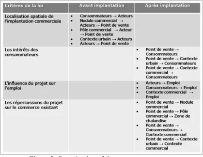
More or less strong dependences thus exist between the various components of the system “retail establishment”. Those were classified on the basis of the 4 legal criteria (figure 2). For example, the dependence “outlet consumer” corresponds to the influence (positive or negative) that a new outlet could have on the consumers of its market area and was classified, on the one hand, considering the criterion “the interests of the consumers” (direct effect) and, on the other hand, considering the criterion “effects on the existing trade”.
Figure 2: Organization of the systemcomponents “Retail establishment” on the basis of the 4 legal criteria
This particular organization must make it possible to put forward a series of questions (or arguments) about a retail establishment project structured on the basis of the legal criteria. These questions will have to find an adapted answer for each case (see point 4).
functionalities). This structure in cards must notably make it possible for the communes to break down a project of retail establishment into its various components in order to facilitate the comprehension and the analysis of it. The encoded information is stored within tables whose attributes correspond to the encoding fields filled in by the user. Each card corresponds to a table and each line of the table to a encodé project. The tables as a whole are included in a database and are connected by a common identifier, the identifier of the project encoded by the user in the first card.
3.3.2. Physical implementation
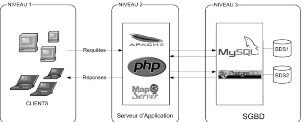
The tool takes the form of a Web site whose main advantage is to be able to centralize the information what facilitates, on the one hand, the updates and, on the other hand, the data and files processing. It is consequently a traditional 3-third architecture (figure 3) made up of a customer layer (level 1), an application server (level 2) and of a data server (level 3).
The software infrastructure selected for the project is exclusively Open Source. The application server combines the use of a Web server Apache coupled with the language PHP (PHP 2008) allowing to interact with the databases, as well as the MapServer application and its bookshop PhpMapScript (MapServer 2008) which allow the realization of cartographic interfaces. These tools do not require any specific installation for the customer, a Web browser is sufficient to use the application. The data handled by the application are at the same time spatial and not spatial. It was thus necessary to select a management system of databases supporting the spatialization of the tables. It is PostgreSQL (PostgreSQL 2008) and its extension PostGIS (PostGIS 2008) which were selected. The spatialization of the tables with PostGIS is in conformity with the recommendations of the Open Geospatial Consortium (OGC 1999). The data and application servers are gathered on the same machine turning with Linux.
Figure 3: Structure 3-third of the tool 4. Functionalities: a step by step process
The philosophy of the project is to bring a help and a method of analysis to the communes without forcing them in their process of decision making. The suggested functioning is a step by step process where the user breaks down the project and analyzes the whole of its components and gradually built his file.
4.1. Global Function
The analysis of a retail establishment file is structured in 3 phases:
1.
Cards: the user encodes the information relating to the project structured in 8 topics (a card = a topic). The following topics are approached: the actors of the project, the products sold, the commercial and urban environments, the accessibility, the market area, the competition and the employment. The encoding is made through fields to fill, some are obligatory and others optional. The cards are consulted in a predetermined order. Throughout the process, an on line help is putted at the disposal of the user (see next phase).2.
The synthesis: the tool processes the data and returns a quantified synthesis summarizing the stakes of the project to the user. To do it, it uses, on the one hand, the data encoded by the user and, on the other hand, its own databases (socio-economic data, cadastre, market area…)3.
The sales leaflet: the user has to work out an outline of formal motivation about the project for the communal decision that has to be taken. It is a question of evaluating the project on various questionings in order to identify some favourable or unfavourable arguments of the project. The tool helps the user to build an opinion about the project structured according to the 4 legal criteria. It does not appear like a block box and proposes the user to choose the scores of each indicator.4.2. Supports and assistances
Throughout the process, a help is placed at the disposal of the user. It is either a specific help appearing in a relevant way during the various stages or a permanent help presents in the menu.
4.2.1. The cartographic application
Among the various supports placed at the disposal of the user, the cartographic application is certainly the most important and strategic. This one makes it possible to have a global and synoptic view of the retail context in which the future project must take place. In a more detailed way, the cartographic application produces, on a given territory, the retail establishments of more than 400 m ² as a whole and meets the following needs.
- To allow to precisely locate any retail establishment of more than 400 m ² on various scales and thus to identify certain retail concentrations.
- To characterize the state of the retail business at various spatial levels. To determine the retail structure of a commune or of a supra communal territory.
- To take note of the potentially concurrent retail offer for the future project on various scales. On the one hand, at the local scale (“which are the retail trade of my commune directly concerned with the project? ”) and, on the other hand, at the scale of the project market area (a widened retail context and often ignored by the communal agent in load of the files).
- To identify the networks of certain big signs and thus to partly include/understand their strategy of development and expansion.
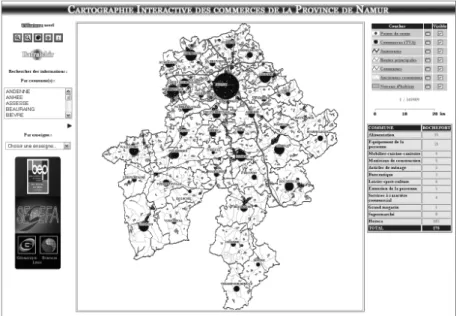
The cartography module of Web2GIS was used as a basis for the realization of this application (Laplanche 2006) with an adapted interface (figure 7). In the centre of this one is the cartographic field. It is possible to directly interact with him thanks to the zoom, displacement and identification tools. The various levels of zoom were reduced to four in order to always produce information on a relevant scale. The result returned by the identification tool, the available layers and their legend depends on the zoom level. Information is read in real-time in order to directly generate the “chart” using the PhpMapScript bookstore.
Figure 4: Interface of the cartographic application
The cartographic interface is based on a client-server Web architecture and only uses Open Source software. Moreover, updates and upgrades of the application are provided by authorized users.
4.2.2. Various assistances
In addition of the cartographic application, the user can permanently have a series of supports and documents at his disposal, allowing him to conclude his analysis. Among those, the most relevant are the following:
- a complete lexicon of all the terms and concepts used as regards retail business;
- an identification of the various polarities and their respective market area within the studied area (Province of Namur);
- a consultation of the socio demographic data of a requested administrative territory; - an employment evaluation within a requested administrative territory;
- a method of on field retail survey. CONCLUSION
Research has provided a tool of decision-making aid, in the form of a Web site entirely based on Open Source products, as regards retail establishment for the communes. It pursues four goals:
- to objectify or even reinforce the opinions of the communal authorities which have the possibility of discussing about the choices to carry out to fill the tool;
- to facilitate the work of certain communes with modest means, notably in terms of diagnosis of the territory thanks to the online information directly available for the user;
- to standardize the advices of the communes submitted to the qualified federal authorities
- to establish a constructive dialog between all the actors concerned with the same project: the commune of establishment, the bordering communes, the applicants and a national socio-economic committee gathering the different lobbies on the matter (Middle-classes, representatives of the consumers…).
At the end, the Commune has an opinion allowing it to take its decision in an objective way concerning a new retail establishment project. All in all, the multidimensional tool elaborated facilitates the diagnosis of a reference territory (the market area of a retail project) while allowing the installation of a participative space gathering the actors at least at two scales: intra-communal and supra communal.
In the long term, the information suggested by the tool and more particularly its cartographic module will be able to become richer with the integration of socio demographic data and additional market areas, or even isochronous curves, that is to say as many useful information for the treatment of the retail establishment difficulties.
Bibliographie
Burt, S.L. and Sparks, L. 2001: The implications of Wal-Mart’s takeover of Asda. Environment and Planning A 33, 1463–87.
Christopherson S., 2002, Limits to Walmartization: lean retailing in merchant and coordinated economies. Department of City and Regional Planning, Cornell University, USA (manuscript available from author). Christopherson, S. 2005, Neither global nor standard: corporate strategies in the new era of labor standards.
Environment and Planning A 37, in press. A VERIF NOW VOIR CHANTAL
Guy, C. (2000) From crinkly sheds to fashion parks: the role of financial investment in the transformation of retail parks, International Review of Retail, Distribution and Consumer Research, 10, pp. 389–400. Hallsworth, A.G. et Evers, D. 2002: The steady advance of Wal-Mart across Europe and changing government
attitudes towards planning and competition. Environment and Planning C: Government and Policy 20, 297–309.
Laplanche F., Environnement de conception de bases de données spatiales sur Internet, Thèse de doctorat en Sciences, Géographie, Université de Liège, 2006.
MapServer. 2008. MapServer. http://mapserver.gis.umn.edu/
Mérenne-Schoumaker B., 1998,"Impacts des mutations du commerce sur la hiérarchie des polarités commerciales, l'exemple de la Belgique", Hommes et Terres du Nord, Vol. 4, 217-224.
Mérenne-Schoumaker B., 2000, L’Internationalisation des entreprises de distribution. Quelques observations au départ du cas européen, Bulletin de l’Association de Géographes français, Vol. 1, 66-73.
Mérenne-Schoumaker B., 2008, Géographie des services et des commerces, Presses universitaires de Rennes, 2e édition, Rennes.
Mérenne-Schoumaker B., Browet A., Bruck, L., Van Overbeke, M., 2004, Localisation du magasin: guide
pratique, 4e édition, Bruxelles, Comité belge de la distribution, 188p.
Metton A. (éditeur.), 2002, Commerces et espaces fragiles, Angers : Collection Commerce et société.
Moati P., MEUBLAT O., 2005, «Comportements et attitudes à l'égard du commerce alimentaire», Cahier de
Recherche du CREDOC, n° 211.
Mutebi, A.M. 2003: Hypermarket regulation in Indonesia, Malaysia and Thailand: causes, forms and directions. Research Working Paper SPP-37–03. Singapore School of Public Policy, National University of Singapore.
Open Geospatial Consortium, Inc. (OGC). 1999. OpenGIS® Simple Features Implementation Specification for SQL version 1.1. http://www.opengeospatial.org/specs/
PHP. 2008. PHP: Hypertext Preprocessor. http://www.php.net/ PostGIS. 2008. http://postgis.refractions.net/
PostgreSQL. 2008. PostgreSQL: The world's most advanced open source database. http://www.postgresql.org
Thomas C., Bromley R. & Tallon A., 2006, New ‘High Streets’ in the Suburbs? The Growing Competitive Impact of Evolving Retail Parks, International Revue of Retail, Distribution and Consumer Research, Vol. 16 (1), pp. 43 – 68
Wrigley N., Coe N., CURRAH A., 2005, Globalizing retail : conceptualizing the distribution-based transnational corporation (TNC), Progress in Human Geography Vol. 29, n°4, pp. 437–457.