Information Disclosure by the
Parliamentary Land Investigation
Commission in Myanmar
February 2017
Towards equitable and secure access to land and natural resources forfamily farmers in the Mekong region
Case Study
Case Study
Written by U San Thein, Khin Pyae Sone and Jean-Christophe Diepart
Reviewed by:
Christian Castellanet, Mekong Region Land Governance Caitlin Pierce, Namati
Natalia Scurrah, Mekong Region Land Governance
For more information contact:
U San Thein: usanthein@gmail.com
Khin Pyae Sone at GRET: pyaesone.land.gret@gmail.com
Jean-Christophe Diepart at Mekong Region Land Governance: jc.diepart@gmail.com
Suggested citation:
San Thein, Pyae Sone and Diepart, J.-C. (2017). Transparency Under Scrutiny. Information
disclosure by the Parliamentary Land Investigation Commission in Myanmar. MRLG Case Study
Series #1. Vientiane: Mekong Region Land Governance.
This work is licensed under a Creative Commons Attribution-NonCommercial-ShareAlike 4.0 International License.
Table of contents
Table of contents i
Executive summary ii
List of acronyms iii
Introduction 1
The Parliamentary Land Investigation Commission: a background 2
A deeper look into the Commission dataset 4
Gaps and silences 4
Urban bias 4
A geography of evasion 6
Conclusion and recommendations 8
Endnotes 9
References and suggested readings 10
Table of contents
Executive summary
In order to address the negative impact that land confiscation has on the development of the country and on its own legitimacy, in 2012 the Union Parliament of the Republic of the Union of Myanmar established an Investigation Commission for the Prevention of Public Disenfranchisements Connected to the Confiscation of Farmland and Other Lands, also known as the Parliamentary Land Investigation Commission (PLIC). The Commission was assigned to examine cases considered to be land grabs and to propose solutions towards releasing the land to its original owners, in most cases smallholder farming families.
This study presents a country-wide quantitative analysis of the Parliamentary Land Investigation Commission reports that were released to the public. Our aim is not just to analyze the information contained in the reports, but also to elicit information they do not reveal. Our succinct analysis allows for the formulation of relevant suggestions to be considered by the current government and non-government bodies involved in different processes of [confiscated] land redistribution, in particular the newly established Central Reinvestigation Committee for Confiscated Farmlands and Other Lands, which was established on 9 June 2016.
We have turned the four Commission reports that were disclosed to the public into a structured dataset that we have used as the basis for our analysis. We found that this dataset presents serious shortcomings in that it fails to provide detailed information about land grabs by the military. Based on the information released, the work of the Commission seems to have targeted urban areas and urbanization projects, which is a view supported by the preponderance of cases in the Yangon, Mandalay and Ayeyarwaddy urban agglomerations as well as by the central role played by the Ministry of Construction as the main body involved in land confiscation. By contrasting the locations of land confiscation cases with those of agro-industrial concessions as of 2011, we also show how the Commission has evaded, rather than tackled, some very critical land confiscation issues driven by these concessions.
We argue for a mechanism that gathers, manages and releases relevant data on land confiscation and redistribution in a manner that allows for full disclosure.
List of acronyms
GAD
General Administration Department
LUASC Land Use Allocation and Scrutinizing Committee
MoAI Ministry of Agriculture and Irrigation (now known as Ministry of Agriculture, Livestock and Irrigation)
MoC Ministry of Construction
MoECaF Ministry of Environmental Conservation and Forestry (now known as Ministry of Natural Resources and Environmental Conservation)
MRLG Mekong Region Land Governance
NLD National League for Democracy
NLRMCC National Land Resources Management Central Committee
PLIC Parliamentary Land Investigation Commission
VFV Vacant, Fallow and Virgin
Introduction
Introduction
Throughout the history of Myanmar – from the colonial era to the present - land has been confiscated by a variety of government bodies, military factions and private corporations, for a variety of purposes: agro-industrial development; hydroelectricity projects; extractive mining industries; urbanization; military projects; etc. (Ferguson, 2014) . This has resulted in institutional, economic and social crises that have jeopardized the rights to land and the livelihoods of smallholder farmers across the country (ALTSEAN, 2014).
The institutional pluralism and weak inter-sector coordination that currently prevails in approving, managing and monitoring land deals is a legacy from the past (Mark, 2016; Srinivas & Hlaing, 2015) as no government thus far has managed to address contradictions and loopholes within a unified land governance framework.
The unrest associated with violent land evictions and displacements has reached critical limits. Civil society groups have engaged counter-movements to address the issues and to seek more justice for smallholder farmers, drawing on a variety of legal and para-legal institutions and strategies as well as protests. In a context of political transition, the Republic of the Union of Myanmar has been increasingly responsive to these issues. However, the process seems uneven as the legal framework instated in 2012 through the Farmland Law and the Vacant, Fallow and Virgin Lands Management Law raises concerns in that it maintains ambiguity, has provided only weak protection of the rights of smallholder farmers in upland areas and because it has primarily paved ways to foster promotion of large-scale agricultural investment (Oberndorf, 2012).
In order to address the negative impacts that land grabs have on the development of the country and on its own legitimacy, in 2012 the Union Parliament established an Investigation Commission for the Prevention of Public Disenfranchisements Connected to the Confiscation of Farmland and Other Lands, also known as the Parliamentary Land Investigation Commission (referred to in this study as ‘the Commission’ or ‘PLIC’). The Commission was assigned to examine cases considered by farmers to be illegal grabs and to propose solutions to release the land to its original owner, in most cases a smallholder farming family (Repubic of the Union of Myanmar, 2013). In a positive move towards more transparency, the Commission has opened up to the public and released the information contained in some of its reports.
A number of fine-grained case studies have revealed the difficulties associated with the effective return of land to an original land owner (Pierce, 2015; Pierce & Huard, 2016; ShareMercy, 2015). But our study aims to take a step back and to present a country-wide quantitative analysis of the Parliamentary Land Investigation Commission reports that were released to the public. We are interested in examining the information contained in these reports but also in eliciting information they do not include. Our succinct analysis allows for the formulation of relevant suggestions to be considered by current government and non-government bodies involved in different processes of [confiscated] land redistribution, in particular the newly established Central Reinvestigation Committee for Confiscated Farmlands and Other Lands, established on 9 June 2016. This case study is also intended to contribute to an MRLG-supported Learning and Alliance initiative aiming to discuss and analyze the current attempts by the new government to address the question of the return of land that was previously confiscated.
Background
The Parliamentary Land Investigation
Commission: a background
The Parliamentary Land Investigation Commission (PLIC) was established by Union Parliament decree No.52/2012 in August 2012 to tackle the return of confiscated farmland and other land and comprises 74 members. It was officially dissolved in 2016, but, in a move to continue the endeavours of the Commission, the new government has initiated the creation of a Central Reinvestigation Committee for Confiscated Farmlands and Others Lands as well as corresponding regional/State committees (Republic of the Union of Myanmar, 2016).
The Commission was tasked with receiving and scrutinizing complaints as well as providing recommendations on the mechanisms that would ensure the effective return of land to the original owners (Repubic of the Union of Myanmar, 2013). Institutionally, the reporting on cases/ recommendations flowed from the Director General of the Parliament Office to the Director General of the Union Government Officei. However, the Commission had no authority to resolve land disputes; it was the Ministry of Home Affairs (through the General Administration Department (GAD)) that was assigned to take action to follow the Commission’s recommendations. Consequently, we are not making an evaluation in this brief about the effectiveness of the actual land return process by the PLIC.
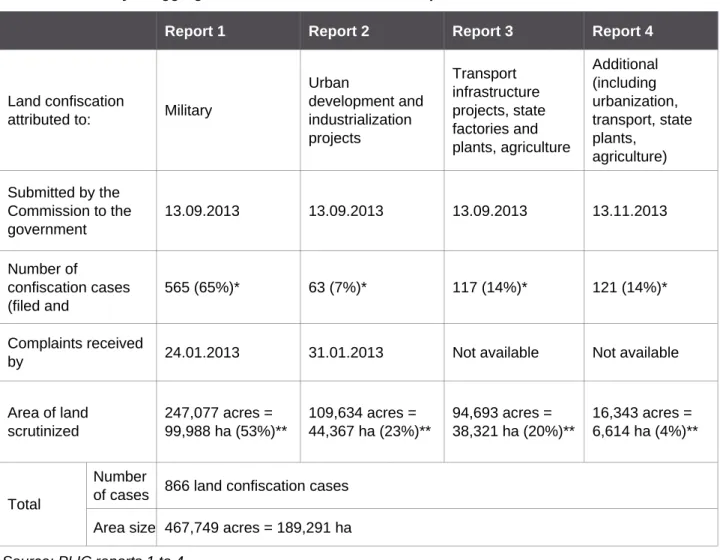
The Commission sent a series of 18 reports to the Union Government Office from 13 September 2013 to 21 January 2016. The 18th report from the Commission to the Union Government Office indicates that 14,756 individual complaints had been received and filed. These reports were subject to divergent interpretations by various stakeholders resulting in important variations in the actual numbers of cases filed, scrutinized and handled by the Commission. This has resulted in some confusion.
In fact, the quality and level of details contained in the Commission reports are not consistent. First, there are indications of duplicate cases as the time periods covered by these reports overlap. Second, data on the characteristics of the land confiscation process and the status of the resolution process is incomplete. Reports 5 to 16 do not contain any quantitative figures on land area confiscated or the number of farmers losing land; they mention only the number of complaints and the number of cases scrutinized. Some cases may contain dozens of affected farmers, while other cases consider only one farmer. It is not clear whether or not detailed information contained in these reports was directly conveyed to GAD for action: this information has not been released to the public. In order to work with one consistent dataset, we decided to focus our analysis on reports 1 to 4 (see Table 1). Although this might present only a fragmented view of the Commission, we suggest that an analysis of the first four reports can still provide insightful observations on the Commission’s endeavours towards addressing land confiscation and promoting transparency.
Each of these reports deals with a specific type of confiscation: i.e. the first report deals with complaints about land confiscated by the military (Republic of the Union of Myanmar, 2013), the second report deals with confiscation by urbanization/industrialization projects (Republic of the Union of Myanmar, 2013a), the third with transport infrastructure as well as agriculture-related land grabbing (Republic of the Union of Myanmar, 2013b), and the fourth with other cases that have not been mentioned in previous reports but pertain to similar categories (Republic of the Union of Myanmar, 2013c).
As can be seen in Table 1 below, the total number of cases filed and scrutinized by the Commission, and detailed in the first four reports, is 866. This number cannot be compared with the total number of complaints (i.e. the 14,756 individual complaints in the 18th report, mentioned above) because these are cases of collective land seizure, meaning that the number of households who were actually affected was more significant. The total area of land at stake was 467,749 acres, (53 percent were military-driven land confiscations). These are aggregate figures, stated as such in the reports; they are not the results of our own computation.
Table 1. Summary of aggregate data released as stated in reports 1 to 4 of the PLIC
Source: PLIC reports 1 to 4.
Note: Figures given here are copied from reports 1 to 4. They are not the result of our own computation. * Percentage represents the share in the total (=866)
** Percentage represents the share in the total (=467,749 acres)
Report 1 Report 2 Report 3 Report 4
Land confiscation
attributed to: Military
Urban development and industrialization projects Transport infrastructure projects, state factories and plants, agriculture Additional (including urbanization, transport, state plants, agriculture) Submitted by the Commission to the government 13.09.2013 13.09.2013 13.09.2013 13.11.2013 Number of confiscation cases (filed and 565 (65%)* 63 (7%)* 117 (14%)* 121 (14%)* Complaints received
by 24.01.2013 31.01.2013 Not available Not available Area of land scrutinized 247,077 acres = 99,988 ha (53%)** 109,634 acres = 44,367 ha (23%)** 94,693 acres = 38,321 ha (20%)** 16,343 acres = 6,614 ha (4%)** Total Number
of cases 866 land confiscation cases Area size 467,749 acres = 189,291 ha
A deeper look into the Commission dataset
Based on the textual information contained in each report, we created a computerized database that provides characteristics about land confiscation cases scrutinized by the Commission. This database has been structured by the land confiscation process and includes data about the location of the cases (state/district/township), which allowed for a representation of the cases on a map ii. The dataset also includes the year of the initial land confiscation, the entity or individual responsible for it, the land area involved, and the number of farmers affected.
Gaps and silences
Our dataset suggests that a total of 283,638 acres (114,784 ha) was scrutinized by the Commission, which involves 186 cases (166 cases only give details of the land area involved) iii. This is significantly less than the aggregated figures announced in the Commission reports (467,749 acres and 866 cases). The core explanation for this gap comes from the fact that all military-related cases were referred directly to the military and reported along different processes and procedures iv. The absence of any information about the military land confiscation cases buried in the first report is problematic given the importance of military-related land confiscation cases in Myanmar, particularly between 1988 and 2011.
Despite the information it gives about location, grabber and land category involved, the dataset is far from complete. The information about the year of confiscation is missing in 80 percent of cases, which makes any analysis of land grabs in relation to the historical circumstances virtually impossible. The information about the number of farmers affected is also missing for most of the cases reported (86 percent). The information gap is even more pronounced when it relates to the area of land actually released to farmers (missing in 95 percent of cases) and the status of the resolution (missing in 74 percent). This seems to suggest that the number of cases actually resolved is more limited than the number of cases scrutinized, which seems to correspond with the Namati report (Pierce, 2015).
Another difficulty is that, although the report indicates the number of cases and areas of the land confiscated that were actually scrutinized, it does not give the total acreage of land that was grabbed in the first place, which might be significantly higher. As a consequence, the database does not provide an accurate estimation of the extent of land grabbing.
In many instances, land was initially confiscated from an original owner and then passed on to other land investors along processes that sometimes involved several transfers. However, the information available in the Commission reports does not capture the institutional complexity of these transfers because, as suggested by Pierce and New Ni Soe (Pierce & Nwe Ni Soe, 2016), the Commission was probably not equipped to tackle this.
Urban bias
On the basis of the information released in reports 1 to 4, the approach and work of the Commission to address land confiscation is overly focused on urban areas and urbanization projects.
A deeper look into the Commission dataset
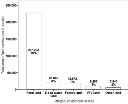
The category of land that was confiscated is primarily farmland, which confirms that it was predominantly farmers who suffered (see Figure 1).
However, the work of the Commission has focused on urban areas just outside of main urban agglomerations (central built-up areas and suburbs). A very significant number of cases (47 percent) and land area (84 percent) of land confiscation scrutinized by the Commission were indeed located in Yangon, Mandalay or Ayeyarwaddy.
Figure 1. Category of land confiscated
Source: Authors’ computation from Commission reports 2 to 4.
Figure 2. Details of projects driving land confiscation
Source: Authors’ computation from Commission reports 2 to 4 Figure 2 confirms the urban focus
of the Commission work in that 51 percent of the project land area involved industrial zones in and outside of Yangon and 14 percent
involved infrastructural development projects (in both rural
and urban areas). The tendency of the Commission to look primarily at urban cases reflects the prime concern of the military governments, which related to urbanization and infrastructure development activities, as depicted in the National Building Grand Strategy.
This contrasts with the much smaller (35 percent) area relating to confiscation by agro-business companies, although they are recognized as major culprits in land confiscation cases.
A deeper look into the Commission dataset
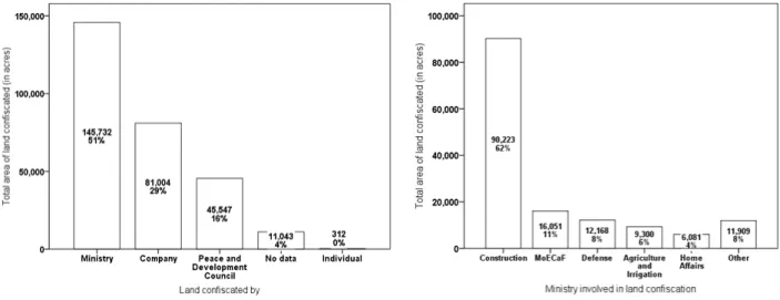
The focus on urban areas reflects the fact that the main land-grabbers are ministerial bodies who have been responsible for 51 percent of the total land area released, among whom the Ministry of Construction (MoC) has accounted for 62 percent of ministry-driven land confiscation cases (see Figures 3 and 4). Confiscation cases by the MoC for urbanization projects are far more significant than cases attributed to the Ministry of Agriculture and Irrigation (MoAI) and the Ministry of Environmental Conservation and Forestry (MoECaF) although the latter has been notoriously involved in land grabs, particularly for agro-industrial concessions.
This urban bias is also quite problematic because it leads to an under-representation of cases in rural areas where land confiscations were in full swing particularly between 1988 and 2011.
Figure 3. Main body involved in land confiscation
Source: Authors’ computation from Commission reports 2 to 4
Figure 4. Ministry involved in land confiscation
Source: Authors’ computation from Commission reports 2 to 4
A geography of evasion
In order to interpret the spatiality of the Commission work, as revealed in reports 1 to 4, we mapped the location of land confiscation cases scrutinized by the Commission between 2012 and 2013 side-by-side with the location of main agro-industrial concessions as of 2011 (see Figure 5).
Adding to the earlier observations on the urban bias, the contrast between both maps reveals that the Commission has not targeted agro-industrial concessions areas where many land confiscations are reported. The map shows the spatial mismatch is particularly striking in Kachin State (rubber and cassava concessions) and Taninthayi (oil palm concessions). Interviews conducted with members of parliament for this study revealed that these regions were purposely avoided by the Commission. All of these observations seem to validate the claim that the Commission has evaded some very critical land confiscations issues rather than tackling them.
Conclusion and recommendations
Conclusion and recommendations
The decision of the Parliamentary Land Investigation Commission to release information about its work to the public was a promising step towards a more accountable relationship between the authority of the State and the people of Myanmar. It is a necessary condition towards more justice for smallholder farmers who have been affected by land confiscation in the past.
Yet the dataset extracted from the Commission reports shows major deficiencies that limit the knowledge that can be inferred from it. And to a certain extent, the dataset proves to be more informative in what it does not show. The key underlying problem is the lack of a clear indication about the methodology designed and deployed by the Commission to identify and scrutinize land confiscation cases.
Our succinct analysis has revealed the fact that the Commission has not made public a significant number of land confiscation cases, particularly those related to the military and to agro -industrial and mining concessions. This has two important implications. First the public information released is a very incomplete basis on which to evaluate the extent of land conflicts in Myanmar. Second, all subsequent efforts by government and non-governmental bodies to return land to the farmers will be incomplete if they base their efforts on the public information released in the Commission reports. How the Commission findings will be linked with new mechanisms under the Central Reinvestigation Committee for Confiscated Farmlands and Other Lands is, however, unclear.
The key recommendation we formulate is to allow full access to the information tackled by the Commission. This will form a basis on which the Commission methodology can be properly assessed and a necessary step - though not sufficient in itself - towards more efficient and fair return of land to dispossessed smallholder farmers.
Endnotes
i In certain cases, information transited via the Land Use Allocation and Scrutinizing Committee
(LUASC), which, in 2014, was expanded into the National Land Resources Management Central Committee (NLRMCC) before being abolished in March 2016 when the National League for Democracy (NLD) government was elected.
ii The information available on the location of each case was limited to the township name. In
order to get the geo-referenced location of the confiscation, we determined the number [x] of confiscation cases within each township and then randomly distributed [x] points within the boundary of the township.
iii The land area of land confiscated is on average 1,708 acres (691 ha) but entails important
variations (standard deviation = 6,838 acres, minimum = 0.009 acres (0.003 ha) and a maximum of 69,000 acres (=27,923 ha).
iv The total aggregate acreage from the reports 2, 3 and 4 is 220,670.77 acres. This figure is
different from the total of the database we constructed based on these reports (283,357 acres). This is partly because some military cases (that were reported along different processes and procedures) are included in reports 2 to 4 and are thus included in our dataset.
References and suggested readings
References and suggested readings
ALTSEAN. (2014). Land confiscation in Burma: a threat to local communities & responsible
investment. Bangkok: Altsean.
Ferguson, J. M. (2014). The scramble for the Waste Lands: Tracking colonial legacies, counterinsurgency and international investment through the lens of land laws in Burma/ Myanmar. Singapore Journal of Tropical Geography, 35, 295–311.
Mark, S. (2016). Are the Odds of Justice “Stacked” Against Them? Challenges and Opportunities for Securing Land Claims by Smallholder Farmers in Myanmar. Critical Asian Studies, 48(3), 443–460. https://doi.org/http://dx.doi.org/10.1080/14672715.2016.1196888
Oberndorf, R. B. (2012). Legal Review of Recently Enacted Farmland Law and Vacant, Fallow
and Virgin Lands Management Law. Yangon: Forest Trends.
Pierce, C. J. (2015). Returns of Grabbed Land in Myanamr: Progress After 2 Years. Yangon: Namati.
Pierce, C. J., & Huard, S. (2016). Land tenure rapid Assessment: Pyapon and Maubin
(Ayeyarwady). Pilot sites for Land Redistribution to Landless. Yangon: Land Core Group.
Pierce, C. J., & Nwe Ni Soe. (2016). Streamlining Institutions to Restore Land and Justice to
Farmers in Myanmar. Yangon: Namati.
Republic of the Union of Myanmar. (2013). Report No 1 of the Investigation Commission for
Prevention of Public Disenfranchisements Connected to Confiscation of Farmland and Other Lands. Naypyi Daw. Retrieved from http://www.mylaff.org/document/view/2486 (English) or
http://www.mylaff.org/document/view/2485 (Myanmar)
Republic of the Union of Myanmar. (2013a). Report No 2 of the Investigation Commission for
Prevention of Public Disenfranchisements Connected to Confiscation of Farmland and Other Lands. Naypyi Daw. Retrieved from http://www.mylaff.org/document/view/2488 (English) or
http://www.mylaff.org/document/view/2487 (Myanmar)
Republic of the Union of Myanmar. (2013b). Report No 3 of the Investigation Commission for
Prevention of Public Disenfranchisements Connected to Confiscation of Farmland and Other Lands. Naypyi Daw. Retrieved from http://www.mylaff.org/document/view/2489 (Myanmar)
Republic of the Union of Myanmar. (2013c). Report No 4 of the Investigation Commission for
Prevention of Public Disenfranchisements Connected to Confiscation of Farmland and Other Lands. Naypyi Daw. Retrieved from http://www.mylaff.org/document/view/3148 (Myanmar)
Republic of the Union of Myanmar. (2016). Central Reinvestigation Committee for Confiscated
Farmlands and Other Lands. Naypyi Daw.
ShareMercy. (2015). Case Studies on How the Government of Myanmar Handles Village People
Whose Lands Have Been Confiscated. Yangon: ShareMercy.
Srinivas, S., & Hlaing, U. S. (2015). Myanmar: Land Tenure Issues and the Impact on Rural
The Mekong Region Land Governance Project aims to contribute to the design of appropriate land policies and practices in the Mekong Region. It responds to national priorities in terms of reducing poverty, improving tenure security, increasing economic development, and supporting family farmers, so that they can be secure and make good decisions on land use and land management. MRLG is operating in Cambodia, Laos, Myanmar and Viet Nam since April 2014, with the support of SDC and the German cooperation. For more information on MRLG, please visit www.mrlg.org.
The MRLG Case Study series analyses specific institutions, projects or policies that occur on issues concerning land security for smallholder farmers in the Mekong Region. It is an empirical inquiry that investigates the object of study within a real-life context. The production of a case study is usually undertaken at the initiative of MRLG but we also accommodate proposals originating from outside the programme.
The views, opinions and interpretations expressed in this publication are those of the authors and contributors. They should not be interpreted as representing the official or unofficial views or positions of SDC.