Northern Ghana Hydrogeological Assessment Project.
9
0
0
Texte intégral
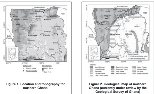
(2) Carrier, Lefebvre, Racicot & Asare Physiography and climate Three broad physiographic regions can be distinguished in northern Ghana: savannah high plains, Voltaian sedimentary basin and scarps. The whole country is generally classified as lowland, with less than 10 % of the country above 300 m elevation. In the north of the country the highest areas (average ~ 500 m) are located around Gambaga and Damongo scarps (Figure 1). The lowest areas are found in the middle of the Voltaian sedimentary basin (see Figures 1 and 2).. Figure 1. Location and topography for northern Ghana. Figure 2. Geological map of northern Ghana (currently under review by the Geological Survey of Ghana). The whole project area is drained by the Volta River system which comprises the Red, Black and White Volta Rivers as well as the Oti River. The total annual runoff of the country is estimated at 54.4 billion m3 (or 54.4 km3) with 38.3 billion m3 accounted for by the Volta River system. High seasonal flow variation is observed for many rivers in the northern regions. The main characteristics of Ghana’s climate are the high temperatures and variable amount, duration and seasonal distribution of rainfall. Temperatures commonly range from 24 °C to 30 °C while extremes range from 18 °C to 40 °C. The climate in the north of the country is generally considered semi-arid with only one rainy season (~ late May to October). Average annual rainfall ranges from 800 mm (north) to around 1 200 mm in the south-eastern part of the project area. Geological context Northern Ghana occupies the eastern portion of the Man Shield (Archean-Proterozoic), which is located in the southern portion of the West African Craton (Archean). It is bounded to the east by the Pan-African Belt and is underlain by two main geological provinces, the Precambrian Basement and Voltaian Provinces. Table 1 presents general lithologies for the project area, based on chroronostratigraphic units (Kesse, 1985). Most of the geological formations in the project area are overlain by a regolith comprising in situ chemically weathered material and, to a lesser extent, transported surface material. Typically, this weathered layer consists (from top to bottom) of a residual soil zone (usually sandy-clayey material possibly underlain by an indurated layer) and a saprolite zone (completely to slightly decomposed rock with decreasing clay content with depth). This regolith usually overlies a saprock zone (remnants of unweathered bedrock in an altered matrix) which is gradually replaced by unweathered, variably fractured bedrock. This weathering profile may however be incomplete in some areas as a result of erosion and depth of the weathering front may not always be well defined. Available information reveals that the thickness of the regolith is generally less than 30 m but can be as high as 140 m in the Upper West Region (Dapaah-Siakwan and Gyau-Boakye, 2000). In the Bongo and Bolgatanga districts of the Upper East Region, the regolith developed over Birimian and Tarkwaian rocks ranges from 12 m to 33 m with an average of 23 m, while it ranges from 3 m to 37 m with an average of 20 m over granitoid intrusions. In sedimentary rock terrains, the regolith would be. 354.
(3) Carrier, Lefebvre, Racicot & Asare. slightly thinner. Previous work in the southern part of the Voltaian Province revealed a regolith of 4 m to 20 m in thickness. The thickness of the residual soil layer, which constitutes the upper part of the regolith, generally ranges from 1 to 3 m but could measure up to 10 m. Outcrop areas are relatively rare except where underlying rocks such as quartz-rich granitoids preferentially resist weathering and develop into inselbergs, in particular in the Upper East Region. Table 1. Description of lithologies in major geological provinces of northern Ghana System. Series Upper Voltaian. Voltaian System. Middle Voltaian Lower Voltaian. -. Buem Series. Tarkwaian System. Huni, Tarkwa, Banket, Kawere Granitoid intrusions. Birimian System. Dominant lithology Massive sandstone, conglomerate with thin beds of shale and mudstone locally Obosum beds - Mudstone, shale, sandstone, conglomerate, some limestone Oti beds - Arkose, sandstone, conglomerate, mudstone, shale, limestone Basal quartz sandstone with pebbly grits and grits Shale, sandstone, lava and tuff with some limestone, grit, conglomerate Sandstone, shale, conglomerate, quartzite, schist, phyllite Mainly granite, granodiorite and gneiss. Upper Birimian. Metamorphosed tuff and lava (andesitic and basaltic). Lower Birimian. Schist, phyllite, slate with greywacke and sandstone. Data collection and compilation. Six existing electronic databases were obtained from Ghana groundwater stakeholders and consolidated under HAP. Database assessment was carried out during the consolidation process to identify unique and reliable records and establish the number of records that met the minimum data requirement for hydrogeological analysis. For HAP purposes, minimum data requirements were set to the following: lithology, groundwater level, yield and water quality (pH, EC, F, Fe, Mn). The project area was divided in cells and data assessment revealed that only 26 of these 507 cells would have at least one unique and reliable record with all required data fields. Additional data are thus required, both in terms of quantity and in terms of spatial distribution, over and above what is currently available in electronic databases in the project area. In the context of HAP, a subset of approximately 500 wells with reliable coordinates and the minimum data requirements will thus be assembled. To create this subset, additional data will initially be collected from the 350 available hydrogeological reports identified and collected by HAP on the basis of the following criteria: • Location (one well per 15 km by 15 km cell); • Representativity of conditions encountered in cell; • Well status (active/usable wells only); • Local knowledge of data reliability (with respect to contractors or consulting engineers). While being time consuming, this activity is expected to yield key information for the hydrogeological analysis required and would represent a significant contribution to the database of the northern regions.. Field work. As part of HAP, 12 new dedicated monitoring wells were constructed in the Northern Region to supplement an existing network of 13 monitoring points established in the three northern regions by the Water Resources Commission (WRC) through the Water Research Institute (WRI) in 2006 (figure 2). The locations of these new monitoring wells were selected through inputs from key stakeholder following a series of project workshops. The criteria notably included areas of stratigraphic importance and areas of known groundwater quality problems. These new monitoring wells have dedicated equipment for long-term measurement of water levels and will allow periodic sampling and lab analyses of water quality. Geophysical techniques (traditional and piloted) were applied to validate well drilling locations, including electromagnetic (EM-34) and resistivity (using 2D imaging techniques). Geophysical down-hole logging (gamma, IP, SP) was carried out in each open borehole, and hydraulic tests were performed to evaluate the hydraulic properties of the rock formations encountered.. 355.
(4) Carrier, Lefebvre, Racicot & Asare. Groundwater conceptual model. Groundwater main regions Hydrogeological provinces of Ghana have been primarily delineated on the basis of geology, which influences groundwater occurrence and availability (Gill, 1969). The two major hydrogeologic provinces in northern Ghana are the Voltaian and Precambrian Basement Provinces. Rocks of the Precambrian Basement Province usually possess low primary porosity and permeability. Groundwater occurrence and flow in this province are therefore mainly controlled by secondary porosity resulting from chemical weathering, faulting and fracturing. Weathering has a significant impact on the storage capacity of crystalline rocks. However, hydrogeological characteristics of aquifers in such environments are highly variable, primarily because of the anisotropic nature of fracture networks and the complexity and variable intensity of weathering processes involved in regolith development. In the Voltaian Province, rocks are generally well consolidated and inherently impermeable. Fracturing, faulting and, to a lesser extent, weathering have however increased the permeability of some of these rocks at the local scale (i.e. mostly for harder, older rocks through tectonic activity or low-grade metamorphism). Typical groundwater occurrence In the Precambrian Basement Province, the most productive zone in terms of groundwater generally comprises the lower part of the saprolite and the upper part of the fractured bedrock (i.e. saprock), which generally complement each other in terms of permeability and storage. The upper, less permeable, part of the saprolite can act as a semi-confining layer for this productive zone while the lower, usually saturated part of the saprolite is characterized by a lower secondary clay content, thus creating a zone of enhanced hydraulic conductivity. On average, areas underlain by rocks of the Birimian or Tarkwaian Systems exhibit deeper weathering (~ 23 m) than areas underlain by granitoids (~ 15 m), mostly as a result of poorer jointing and fracturing in the latter. This generally results in a shallower water table and lower borehole yields for the granitoid areas. Within the upper fractured bedrock, aquifers are generally associated with subhorizontal fractures related to isostatic uplift resulting from the removal of overlying material (e.g. erosion or dissolution during weathering). While transmissivity is reported to decrease with depth as fractures close under the increasing overlying weight, the information available suggests that important subvertical fracture or fault zones can be present at great depths and provide significant amounts of groundwater. Average borehole depth is however less than 80 m in general (Agyekum, 2004). In the Birimian System, rocks intruded by quartz-veins or pegmatites are also known to yield relatively higher quantities of groundwater. In some cases, hydraulic connectivity between the lower saprolite and the saprock may vary with weathering intensity and fracture characteristics and lead to separate aquifer systems. When taken separately, the regolith aquifer can exhibit a higher transmissivity than the fractured rock aquifer because of its generally greater saturated thickness. The impervious nature of the upper part of the regolith or the presence of an indurated layer at the base of the residual soil zone can lead to the development of a shallow perched aquifer if the upper part of the residual soil zone consists of coarsely textured material. Documentation on the occurrence of shallow aquifers is not available. Groundwater in the Voltaian Province mainly occurs and flows in fracture zones, and along bedding planes for some areas, since the primary porosity of these rocks was destroyed through consolidation and cementation. The regolith is reported to be unsaturated in many areas and would thus only provide minor amounts of groundwater locally (Acheampong and Hess, 1998). The average thickness of the regolith over the Voltaian sedimentary rocks is approximately 9 m. Previous investigations in the Nanumba and West Gonja districts revealed average regolith thickness of 6 m and 11 m, respectively. The relatively thin regolith can be partly explained by the stable clay (shale) or quartz (sandstone) composition or by the fine texture or ductile nature (soft unmetamorphosed mudstone) of sedimentary rocks found in the Voltaian Province. Deeper weathering may however occur in some areas, such as those underlain by arkose or arkosic sandstone (e.g. Oti Beds of Middle Voltaian) as K-feldspar weathers more easily than quartz and clay minerals. Underlying fracture zones are generally developed in bedrock at depths greater than 20 m below ground surface but, on average, required yields for rural supplies are obtained above 100 m depth. However, production potential from deeper fractures has not been investigated thoroughly. Fracture characteristics such as frequency, aperture and connectivity can vary substantially over small distances, making it difficult to locate laterally extensive aquifers. Bannerman (1990) reports that most productive fracture zones in the West Gonja district of the Northern Region occur between 13 m and 80 m with an average depth of 27 m. As in the Precambrian Province, the upper part of the regolith can acts as a semi-confining layer where it is thick enough. Shallow perched aquifers can also be encountered where coarsely textured material overlies a less permeable layer such as ferricrete.. 356.
(5) Carrier, Lefebvre, Racicot & Asare. Groundwater productivity and well installation In crystalline rocks areas, integrated aquifer systems formed by the regolith and fractured rock aquifers are mainly exploited with boreholes, which are generally cased though the unconsolidated material, grouted above the screen (or open-hole) section and in the first 5 m of the borehole (Ofosu, 2005). The borehole is generally finished with a concrete pad at the surface for protection against preferential infiltration. Where open-hole design is not feasible, screened sections made of slotted PVC are generally installed. Depth of boreholes drilled in rocks of the Birimian and Tarkwaian Systems (~ 13 % of project area) generally range from 35 m to 62 m with an average of 42 m (Agyekum, 2004). For areas underlain by granitoid intrusions (~ 27 % of project area), borehole depths are similar, ranging approximately from 35 m to 55 m with an average of 50 m. In some areas, the regolith aquifer is also tapped with relatively shallow hand-dug wells. In Ghana, data on hand-dug wells were not systematically recorded until recently, through inventories carried out by various institutions. A local inventory performed in the Atankwidi catchment (Upper East Region) revealed that average depth of traditional hand-dug wells would be around 6 m while that of modern hand-dug wells would be around 10 m (Martin, 2006). Modern hand-dug are differentiated from traditional ones as they are generally constructed with NGOs support and are usually deeper and lined with concrete. Hand dug wells can also be used to exploit shallow aquifers although such aquifers do not usually yield water all year long, which causes rural population to return to non-potable sources near the end of the dry season. Transmissivity of the productive zone for the Birimian and Tarkwaian Systems ranges approximately from 0.2 m2/d to 119 m2/d, with a relatively low average of 7.4 m2/d. Storativity, which can be largely attributed to the high porosity of the lower part of the regolith, ranges from 0.003 to 0.008. The few data available for regolith aquifers alone come from recent work in the Upper East Region (Martin, 2006) and indicate that transmissivity would be slightly higher than that of the integrated aquifer system, with values ranging from 4 m2/d to 40 m2/d with an average above 10 m2/d. For the integrated aquifer system, borehole yields are generally low, ranging from 0.48 m3/h to 36 m3/h with a mean yield of 7.6 m3/h. For areas underlain by granitoids, transmissivity ranges from 0.3 m2/d to 114 m2/d with an average of 6.6 m2/d while borehole yields range from 0.3 m3/h to 36.4 m3/h with a mean of 4.0 m3/h. Differences in degree of weathering and fracturing can partly explain the lower yield and transmissivity values for granitoids. Available data reveals that boreholes in the Voltaian Province are on average slightly deeper than those of the Precambrian Basement Province. Borehole depths would range from 45 m to 75 m with a mean depth of 55 m (Agyekum, 2004) although other sources indicate borehole depths of up to 355 m. Previous work in the Northern Region (Kwei, 1997) revealed that average hand-dug well depth would range from 2 to 20 m. In some areas, hand-dug wells are however not considered a good option as water levels would be considerably lower than bedrock surface. Fractured rock aquifers of the Voltaian Province would generally have a low to moderate productivity and overall transmissivity would range from 0.3 m2/d to 267 m2/d with an average of 11.9 m2/d. Existing data reveals that borehole yields range from 0.3 m3/h to 72 m3/h with a mean yield of 7.3 m3/h. To explain the variability of borehole yields and the low success rate in this province, Acheampong and Hess (1998) suggest that water-bearing structures would be discrete entities with highly variable production rates. This would support assumptions that groundwater occurrence is mainly controlled by geologic structures. Conceptual model The conceptual model presented here is largely based on similar, existing conceptual models describing hydrogeological contexts in semi-arid and arid climates, where chemical weathering is prevalent (Chilton and Foster, 1995; Martin 2006). The primary objective in establishing this conceptual model is to relate typical lithological units to general hydrostratigraphic units at a regional scale. Available stratigraphic logs from collected reports and HAP consolidated database have been used to develop this model. Even though there can be large variations in thickness, lateral extent and composition of the regolith depending on location and underlying lithology, the main weathering zones described earlier are generally valid for sedimentary and crystalline rocks. Figure 3 presents the typical weathered zones for the Precambrian Basement and Voltaian Provinces of northern Ghana with their associated hydrostratigraphic units. In the crystalline rocks, intermittent perched aquifers can sometimes be encountered in the shallow residual soil layer if coarsely textured material overlies a less permeable layer. When unsaturated, the field capacity of this layer partly determines the amount of recharge reaching underlying aquifers. Typically, permeability of this layer decreases rapidly towards the underlying saprolite or indurated layer. The main aquifer, as depicted in the model, corresponds to the integrated aquifer system discussed above. In figure 3, the saprolite. 357.
(6) Carrier, Lefebvre, Racicot & Asare. is defined as a leaky aquifer but it mainly acts as a reservoir for the underlying fractures. It is characterized by two distinctive zones, an upper almost completely decomposed zone, and a lower highly weathered zone. The lower, usually productive zone has an enhanced hydraulic conductivity and retains a much higher proportion of primary minerals than the upper part, which is typically unsaturated with a high proportion of secondary clay. The underlying fractured aquifer may also be divided into two categories, the boundary between the two being not always well-defined. The upper part is generally associated with sub-horizontal fractures resulting from surface decompression. While it usually has a higher fracture density than the lower part, it can also have lower permeability as slight weathering can result in secondary clay minerals in-filling and sealing fractures. Depending on local conditions, groundwater can leak from the overlying saprolite and recharge this aquifer. The lower part would be more variable laterally as it corresponds to subvertical fractures generated by tectonic forces. The frequency and permeability of such fractures decreases with depth. For the integrated aquifer system, the average groundwater level would fall in the saprolite even though significant water strikes are usually not encountered before the saprolite base because of the low permeability of overlying material. This is sometimes misinterpreted as semi-confined conditions.. Figure 3. Conceptual model relating general lithologies to typical hydrostratigraphic units. In the sedimentary rocks of the Voltaian Province, the main aquifer is generally located in fractured rock as the regolith is often too thin to store significant amounts of water. Consequently, water levels are generally deeper than in the crystalline rock aquifers and fall near or below the base of the regolith. The relatively thin and sandy regolith developed over rocks such as sandstone and siltstone would, on the other hand, facilitate recharge to the underlying fractured aquifer. The thickness and extent of the upper fracture zone is highly variable (Bannerman, 1990). Shallow perched aquifers could also be found locally, where surface material allows, although information on such aquifers has not been recorded. While lithology has a major influence on groundwater occurrence, geomorphology, tectonics and topography can also exert significant control on the geometry, extent and presence of aquifers. Consequently, further refinement of the model will attempt to consider their influence.. Groundwater recharge. Initial water balance A simple soil moisture model was used with the upper soil layer acting as a single reservoir with field capacity as the maximum reservoir capacity. The average field capacity (Fc) used was 102 mm based on a previous study carried out in Ghana (Acheampong, 1988). As little information was available for the upper soil layer characteristics, the conceptual model used for the recharge estimate was further simplified by considering all soil water as readily available water, and assuming the evapotranspiration rate equals the potential evapotranspiration until readily available soil water is exhausted. 358.
(7) Carrier, Lefebvre, Racicot & Asare. Table 2. Summary of soil moisture balance results for 1971-2001 period (mm of H2O & % of rain) Station. Navrongo. Wa. Tamale. Yendi. Bole. Kete-Krachi. Region. Upper East. Upper West. Northern. Northern. Northern. Volta. Units. (mm). (%). (mm). (%). (mm). (%). (mm). (%). (mm). (%). (mm). (%). Potential evapotr. (pET). 1723. -. 1770. -. 1839. -. 1710. -. 1541. -. 1606. -. Precipitation (P). 987. 100. 1007. 100. 1083. 100. 1192. 100. 1069. 100. 1346. 100. Runoff (Q). 123. 12.5. 126. 12.5. 135. 12.5. 149. 12.5. 134. 12.5. 168. 12.5. Actual evapotr. (aET). 798. 80.9. 866. 86.0. 913. 84.3. 910. 76.3. 908. 85.0. 956. 71.0. Recharge (R). 65. 6.6. 15. 1.5. 34. 3.2. 133. 11.2. 27. 2.5. 222. 16. Monthly datasets, made available by the Ghana Meteorological Service Department (MSD), were used to calculate the soil water balance at six meteorological stations: five inside the project area (Navrongo, Wa, Bole, Tamale, Yendi - locations shown on figure 1) and one slightly outside (Kete-Krachi). Results for the monthly water balance calculations over the 1971 to 2001 period are summarized in table 2. The average annual precipitation for the stations ranged between 987 mm and 1346 mm while potential evapotranspiration (pET) ranged from 1541 mm to 1839 mm. Values of pET were computed with the Penman-Monteith method recommended by the Food and Agriculture Organisation (FAO). The validity of this method has been demonstrated in humid and dry climates. Runoff was estimated to be 12.5 % of precipitation and used as a constant coefficient for calculations. The Curve Number method was also applied for one station (Navrongo) using daily climate data and yielded a similar result. Further evaluation of runoff coefficient is however desirable in order to validate these estimates. Soil moisture balance results for the six stations (e.g. figure 4) revealed only one rainy season with evapotranspiration as the dominant component (71-86 % of annual precipitation).. Figure 4. Average monthly soil moisture balance for a selected station for the period 1971-2001. Calculated recharge ranges from 1.5 to 11.2 % of mean annual precipitation (15 mm to 133 mm) and, for 3 out of the 6 meteorological stations considered (Wa, Tamale, Bole), the soil moisture balance indicates a single month during the year in which recharge would occur. These results are generally in agreement with previous work carried out at much more local scale in the northern Regions. Results also revealed that recharge values can vary significantly with precipitation and pET, especially during the rainy season when the duration and number of precipitation events are crucial to groundwater recharge. The Chloride Mass Balance (CMB) method in the unsaturated zone will be implemented in an upcoming phase of HAP to validate estimates obtained from the soil water balance, and to assess the variability of groundwater recharge in space and time. Related field work would include the drilling of 15-20 boreholes, located near existing or new monitoring wells. Collection of unsaturated zone soil samples for chloride content analysis of the pore water will be done at 0,3 m (1 ft) intervals until the water table is reached or until a maximum depth of 20 m (or bedrock) is reached. Precipitation samples currently being collected from the MSD meteorological stations will also be analysed for chloride content.. 359.
(8) Carrier, Lefebvre, Racicot & Asare. Conclusion. Main results and findings As part of the Hydrogeological Assessment Project (HAP), the inventory, collection, validation and synthesis of existing hydrogeological information were carried out for the three northern regions of Ghana. Relevant publications and reports were electronically preserved for future reference and dissemination among Ghanaian stakeholders of the water sector. Data from six electronic databases were validated and consolidated in one database to serve as a basis for future hydrogeological projects in northern Ghana as well as HAP downstream activities. Field data were also collected through drilling and construction of 12 new monitoring wells that supplemented the existing monitoring well network. Collected data allowed the definition of general hydrogeological contexts for the two major geological provinces, the Precambrian Basement and the Voltaian Province. Average values of key hydrogeological parameters were summarized for each of these provinces and a preliminary conceptual model was developed to relate typical lithological units to hydrostratigraphic units. In crystalline rocks, the saprolite is defined as a leaky aquifer but it mainly acts as a reservoir for the underlying fractures that would provide most of the yield. The lower saprolite can also provide significant amounts of water when weathering has enhanced hydraulic conductivity. In the Voltaian Province, the main aquifer is generally located in fractured rock as the regolith is often too thin to store significant amounts of water. Water levels are thus generally deeper than in the crystalline rock aquifers and fall near or below the base of the regolith. Groundwater recharge was evaluated through a soil moisture balance carried out with monthly climate data and compared with known recharge rates in northern Ghana. Calculated rates of recharge range from 1.5 to 11.2 % of mean annual precipitation (15 mm to 133 mm). Future work The assessment and consolidation of electronic databases notably revealed that additional data is required, both in terms of quantity and in terms of spatial distribution in the project area, to allow required analyses at the project scale. Consequently, if available information allows, a subset of approximately 500 wells with reliable coordinates and minimum data requirements will be created through the collection of data in hard copies of documents. Additional field data will also be collected through a regional groundwater level survey and a groundwater quality sampling campaign for all monitoring wells. Long-term groundwater level fluctuation data will be collected from each monitoring well to eventually allow the preparation of a regional piezometric map and to help determine groundwater flow paths and possible locations of recharge and discharge areas. Finally, groundwater recharge will be further investigated through the chloride mass balance method which will notably serve to assess the variability of groundwater recharge in space and time. Acknowledgements The authors acknowledge the support of HAP, funded by CIDA. They would like to thank the WRC and WRI for their contribution on this project, and also thank CWSA, WVI and GLOWA project for the data they provided. Finally, the Ghana Geological Survey is also thanked for their continued collaboration. References Acheampong, P.K. (1988) Water balance analysis for Ghana. Geography Vol. 73, No. 2, pp. 125-131. Acheampong, S.Y. and Hess, J.W. (1998) Hydrogeologic and hydrochemical framework of the shallow groundwater system in the southern Voltaian Sedimentary Basin, Ghana. Hydrogeology Journal Vol. 6, No. 4. pp. 527-537. Agyekum, W.A. (2004) “Groundwater resources of Ghana with the focus on international shared aquifer boundaries” in B. Appelgreen (ed.) UNESCO-ISARM International Workshop - Managing shared aquifer resources in Africa, Tripoli, Lybia, June 2002. United Nations, IHP-VI Series on groundwater no.8, pp. 77-85. Bannerman, R.R. (1990) Appraisal of hydrogeological conditions and analysis of boreholes in the Nanumba and Western Gonja Districts, Northern Region, Ghana. Final report for Rural Action NORRIP/ GTZ, April 1990, 44 p. Carrier, M.-A., Racicot, J., Asare, E.B., Lefebvre, R. and Rivera, A. (2006) Bibliographical review of selected papers – Hydrogeological Assessment Project of the Northern Regions of Ghana. Unpublished report, 64 p.. 360.
(9) Carrier, Lefebvre, Racicot & Asare. Chilton, P.J., and Foster, S.S.D. (1995) Hydrogeological characterization and water-supply potential of basement aquifers in tropical Africa. Hydrogeology Journal Vol. 3, No. 1, pp. 36-49. Dapaah-Siakwan, S. and Gyau-Boakye, P. (2000) Hydrogeologic framework and borehole yields in Ghana. Hydrogeology Journal Vol. 8, No. 4, pp. 405-416. Gill, H.E. (1969) A ground-water reconnaissance of the Republic of Ghana, with a description of geohydrologic provinces. US Geological Survey Water-Supply Paper 1757-K. Kesse, G.O. (1985) The mineral and rock resources of Ghana. Balkema, Rotterdam, 610 p. Kwei, C.A. (1997) Evaluation of groundwater potential in the Northern Region of Ghana. Report for the Canadian International Development Agency, March 1997, 66 p. Martin, N. (2006) Development of a water balance for the Atankwidi catchment, West Africa – A case study of groundwater recharge in a semi-arid climate. Cuvillier Verlag, Göttingen, Germany, 169 p. Ofosu, S. (2005) The Hydrogeology of the Voltaian Formation of the Northern Region of Ghana. M.Sc. Thesis. University of Reno, Nevada, U.S.A. Keywords Northern Ghana, regional aquifer study, conceptual model, recharge, database Contact details Marc-André Carrier, Graduate student INRS-Eau, Terre et Environnement, Quebec, Canada Email: [email protected]. Enoch B. Asare, Senior Hydrogeologist Water Resources Commission, Accra, Ghana Email: [email protected]. 361.
(10)
Figure


Documents relatifs
L’archive ouverte pluridisciplinaire HAL, est destinée au dépôt et à la diffusion de documents scientifiques de niveau recherche, publiés ou non, émanant des
A simple kinetic model of the solar corona has been developed at BISA (Pier- rard & Lamy 2003) in order to study the temperatures of the solar ions in coronal regions
One way of controlling the doping level is shown on Figure 3a: as ligand exchange is conducted on a film of HgSe CQD, the absorption spectrum is strongly affected: at the
We present an historical review on radio observations of comets, focusing on the results from our group, and including recent observations with the Nançay radio telescope, the
The use coefficient was abandoned in 2010 because it failed to reflect the actual extraction rates and may even have underestimated extraction levels (Rinaudo and Donoso,
In South Africa, the policy of apartheid and, in particular, the Tomlinson Commis- sion of 1955 forged a strong link between irrigation and terri tory becau se, in an effort
N Amongst climate variables, we highlight the predominant role of water availability in determining seasonal variation in tree growth of neotropical forest trees and the need to
Two different scaling regimes are observed at small and large scale with Hurst exponent around 1 and 0,5 respectively. Averaged wavelet coefficient spectrum of the
