POLIS : a Project Information System for Urban
Environmental Design
Jacques Teller
LEMA•University of Liège,
15, avenue des Tilleuls, D1, 4000, Liège (BE). tel +32 4 366 93 67
e-mail : [email protected] http://www.ulg.ac.be/lema
ABSTRACT
This paper consists in a short presentation of the POLIS project (EC-DGXII, Directorate "F" - R&TD : Energy). Part of the project consists in the development of a Project Information System (TOWNSCOPE) dedicated to energy concerns at the urban design detail level. The system includes solar access, wind patterns, daylight, ambiant pollutants and morphology analyses that are briefly described in this paper.
1. General presentation of POLIS
The POLIS project (1996-1998) is devoted to "Urban Planning Research Actions to Improve Solar Access, Passive Cooling and Microclimate". The financial support of the project is the European Commission - DG XII, Directorate "F" - R&TD : Energy.
POLIS main objective is to produce a design guidance on urban layout to ensure good access to solar gain, daylighting and passive cooling. The aim is to enable designers to produce comfortable, energy efficient buildings surrounded by pleasant outdoor spaces. In order to meet this general objective the POLIS project has foreseen 5 type of deliverables :
1. theoretical models of solar access, wind pattern, daylight and ambiant pollutant dispersal in an urban layout ;
2. simple manual tools to calculate solar access and daylight availability on obstructed sites ;
3. practical case studies, including two major case studies of southern European sites, to test and illustrate the evaluation tools ;
4. a paper printed illustrated design guide ;
5. an integrated computer software to evaluate solar access and wind patterns within urban configurations in Europe.
The POLIS research team is composed of 4 partners. 1) POLIS coordinator is the DOE-BRE (Department of Environment - Building Research Establishment). There are two Southern University research staffs, one from 2) University of Athens, the other from 3) University of Sevilia. 4) The LEMA has to develop the computer software (T0WNSCOPE) that will gather each partners computer tools.
TOWNSCOPE role is thus an integrative role. It consists in a computer urban database, in procedures for data acquisition and exchanges, coupled with various evaluations and/or external applications. This has led us to define it as a Project Information System (P.I.S.). 2. POLIS urban space scale
POLIS is involved at an urban design detail level. This one generally covers a range of 1:200 to 1:1000. Its purpose consists in the management of the interactions i) between an urban space and its context and ii) between the many components of an urban space.
For these objectives, it is not possible to model a cluster through a single volume (as is often the case at an urban planning detail level) since the height variations between the different buildings often have a significant impact on the central space legibility. It's the same for the public spaces that can not be analyzed as a whole. The urban design precisely deals with the interactions between sub-spaces : roadways, pedestrians, reservations and so on. All the technical network have also to be located precisely in three dimension.
It is not either possible to model every room, internal walls, façades, and internal technical nets of each building (as is the case at the construction detail level) since this would cause a rapid overflow of the information system limits.
Common units of urban design are thus : buildings, public spaces and sub-spaces, pedestrian networks, small and medium public technical nets and so on.
3. COST UCE Action C4 framework
The re-development of TOWNSCOPE has been oriented in order to fit the general COST-Action C4 framework (figure 1). Let's briefly summarize this framework (figure 1). 3.1. Three external information systems (I, III, IV)
The COST C4 has distinguished 3 main urban information sources [DUPA-96c] : I- Existing Urban Databases and GIS (geographic information systems) where general, permanent information about the urban physical context is stored. The urban project has to collect its starting information in these databases.
IV- This information is, most of the time, insufficiently detailed to allow the development of an actual urban project. It is nearly always necessary to complete these informations using other sources. These sources may be private, temporary or local. They can also be obtained using direct acquisition techniques (photogrametry, laser techniques, etc.).
III- Finally the many private urban construction projects will generate their own information, dedicated to their own purposes. This one can be generated with CAD, or other softwares, but the COST C4 has to allow some direct information exchanges between the many private urban construction projects and the more 'collective' urban project.
A clear separation between these information sources allows to avoid un-authorized mutual intrusions. But this division would also help controlling the updating of the contained data. Non-symmetric rules have been set up for the information transfer through a KBMS (Knowledge Based Management System).
permanent and general information sources interfaces II IV urban construction temporary and local information sources knowledge based management system P.I.S. project information system Application system application driven representation application system I V VI VII III
Figure 1. COST UCE - ACTION C4 General Framework [DUPA-96c]
2.2. The Project Information System (V.)
The data, knowledge and information related to the urban project (to be distinguished from the urban construction project) is integrated in a specific Information System called the P.I.S. (Project Information System).
2.3. Applications (VI. and VII.)
The urban project specification will require the definition of various “performances” either applied to the central space, to the individual constructions, to the whole building layout etc. These performances evaluation often require specialized applications when they’re not as trivial as defining a maximum height for the construction. An application system is then required in order to improve the urban project specification formalisms. 4. TOWNSCOPE framework
It is not useful nor possible to implement the whole COST C4 framework within TOWNSCOPE. In Polis, the main efforts will be dedicated to the central P.I.S. and the several applications it deserves.
4.1. Two information sources
TOWNSCOPE has two different information sources :
a) data importation and exportation between POLIS and external databases via static exchange format. In a first step, we decided to concentrate on geometrical entities exchanges that were mandatory for our energy evaluations purposes.
b) direct data acquisition tools, with a digitizer and/or mouse+screen for the additional information encoding and manipulation. This interface is composed of a very simple solid modeller and some basic GUI functionalities : selection, modification, attribution.
In TOWNSCOPE, one has to use these two interfaces for the modelling of construction projects. In a further step, this data exchange should result in a more specific interface, but this is not part of POLIS tasks. The control of data exchanges between the P.I.S. and external Information System remains under the responsibility of the system’ user. We will not implement nor integrate a KBMS for this task that would constitute a whole project in itself.
4.2. The P.I.S.
All the system information is stored in an object-oriented database. The one chosen is ObjectStore for its strong integration with our development tools (CLOS).
TOWNSCOPE provides relevant information to its applications, and eventually stores the evaluation results in the DB. For instance, the sunshine hours reaching some construction faces are used for evaluating the construction internal consumption. This information, the sunshine hours on specific faces, is computed by the solar access application and has thus to be stored in the DB.
The PIS includes a decision module where the many results of the various applications are gathered and combined. The algorithm chosen in TOWNSCOPE is PROMETHEE which is based on multi-criteriae analysis methods. This technique is used for the comparison of different urban construction projects according to different criteriae balanced according to the urban project decision makers preferences.
4.3. The application system
Polis will include several applications : solar access, daylight analyses, wind patterns analyses, ambiant polluants dispersion or concentrations, urban morphology and dynamic perception analyses.
As one can see, these applications are related to energy conservation, thermal comfort, and urban open space quality assessment. We could of course extend this field during the project.
5. Short presentation of the various TOWNSCOPE application modules 5.1. Solar access
In TOWNSCOPE, a special attention is drawn on three aspects.
1) It is not careful to apply energy conservation optimisations for single, isolated, buildings. It is quite clear that, in an urban project context, local improvement of a building solar performances may have significative negative effects on the whole buildings context. These negative effects may largely overcome the small optimizations given to the single building. This kind of situation do often generate 'urban conflicts' in the direct neighborhood of the building.
2) On the other hand, one cannot imagine to freeze any urban redevelopment in order to preserve de facto situations where some people would have an exceptional solar access !
3) Finally, one can neither neglect the quality of public open spaces. These can also be affected by solar access, and it is not usually part of the designers main considerations. Moreover the local population involvement in these problems is not a good guarantee for a safe solar access design, since the people that live in a place and not always the same as the one that are using its public open spaces.
The urban solar access improvement has thus to take into consideration the whole urban context where it takes place. This includes the construction itself of course, but also its neighbors and the public open spaces. By this way, we intend to give the local opportunities some more 'objective' means to balance the private, collective and public aspects of the solar access at an urban design scale.
We thus foresee both global and local analyses in TOWNSCOPE :
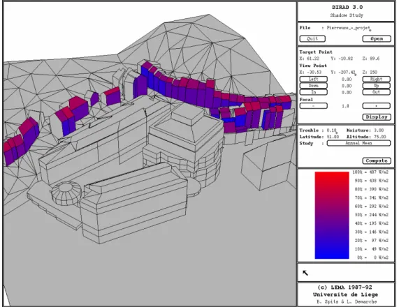
- the global analyses (figure 2) are used in order to evaluate one project' overall impact in/on its surrounding. They take as input the general description of the site and produce a comprehensive visualization of the direct solar radiation reaching all the relevant faces.
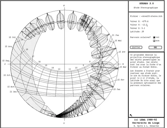
- local analyses (figure 3) are complementary to these and offer more specific informations in some special points [DUPA-96b]. They are based on spherical analyses (stereographical + isoaire analyses). They give the sunshine hours, direct and diffuse radiation reaching a point located anywhere in the site.
5.2. Daylight
We focus on daylight available within the buildings given their local urban context. The computation methods are mainly predictive tools, best fitted for comparisons purposes. These simplified methods derive from manual evaluation tools established by P. LITTLEFAIR [LITT-91]. The product of these analyses are daylight and sunshine availability on the windows (skylight indicator and sunlight availability indicator) and/or the internal floors (no-sky line area). We do not compute the effective distribution of illuminance within the rooms, which would require quite elaborated models of the constructions with all the internal faces and their luminosity characteristics. These informations are not usually available at the design stage.
Figure 3. Stereographical local analysis in the EXPO LISBOA'98 site
5.3. Wind patterns
In Polis we've distinguished two kind of wind patterns evaluation modules according to the design stage involved in the computation.
1) Simplified tools, based on the GANDMER method [GAND-76], are used at the very preliminary design stage of the urban project (rough building bulk forms available). They produce “maps of incomfort risks” by the identification of some critical situations (Venturi effect, WISE effect, bar effect) and their possible combinations. These critical situations have been formalized by GANDMER by series of tests in wind tunnel. They consist in a set of buildings topological configurations and their respective wind incomfort risk. The role of the LEMA is thus to systematize the recognition of such critical configurations within a whole urban pattern.
2) Computer Fluids Dynamics (CFD) analyses that computes the air flows in urban open spaces. These analyses can only be performed with very detailed models given the importance of the local and the boundary conditions in these analyses [SANT-96]. They produce a complete description of wind flows (directions + intensities) within complex 3D spaces. These tools have already been successfully applied by the University of Athens to two real case studies.
5.4. Ambiant polluants
The ambiant polluants dispersion and concentration will be studied through simplified models under construction at the BRE.
5.5. Urban morphology
LEMA’s urban morphology methods analyze the confinement, landmark and glimpses of urban open spaces [DUPA-96b]. These open spaces (the 'cores') may be places, streets, parvis, courts, alleys and so on. These complex three-dimensional entities are rather theoretical since their shape is always defined by external and quite independant entities : the various structures, floors, walls and enclosures and elements that delineate their borders. The cores limits are often discontinuous. They can also stay fuzzy and unclear, especially where they’re adjacent to other cores (at the articulations areas) or in special urban forms (city edge areas for instance).
The main objective of our morphology analyses is to afford quantified evaluations of these cores' perceptive qualities.
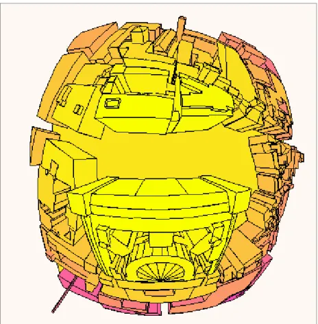
LEMA's methods are based on spherical projections in order to integrate the full 3D visual environment of the observer. Moreover the spherical projections are much more formalized than the usual perspective representations. They perform the visual representation in two separate steps : 1) projection from the 'world' to the sphere and 2) projection from the sphere to a plane. It is the second transformation that affects the properties of the representation. 'Isoaire' projections respects the solid angle of the sky, 'equidistant' projections respects the vertical angles, 'stereographical' are best fitted to solar analyses and so on. This explicit formalism of the representation properties is well suited to our quantitative requirements
The figure 4 is a stereographical representation (view from the sky) of the piazza del Parlemento in Rome. These kind of views are used to analyze i) the visual connections (landmarks, glimpse, ...) between one core and its neighbors, ii) the relations between the core ground and the core faces (axiality, enclosure, discontinuities, ...).
Figure 4. Spherical representations of the Piazza del Parlemento in Rome
6. Conclusion
The Polis project can be seen as a limited case study of the COST UCE - Action C4 framework. It mainly consists in the development of a P.I.S. (TOWNSCOPE) connected to various urban applications.
These applications are highly oriented towards energy and perceptive concerns : solar access, daylight, comfort in outdoor spaces, wind patterns, morphology analyses. All these topics cover only part of the vastness of urban design potential evaluation requirements : accessibility, traffic, security and so on.
But it is neither Polis nor COST UCE C4 objectives to develop a single rigid system that would be applied in the same way for all possible situations. Their objective is rather to connect new applications to the existing P.I.S. so that the application system is an opened system adapted to each specific urban project.
In this dynamic perspective, one can see that :
1- the relevant informations, the ones that have to be included in the system, can not be decided a priori for a project under design since these are function of the project type and the main intentions of its authors.
2- the information structure, the way the built environment is modelled and the formalization of analytic concepts, may also vary from one project to another, or from one area to another; the information may thus be discontinuous and heterogeneous ;
3- the selection of the appropriate procedures for evaluating one specific aspect of the project may also be dependent of the context and objectives ; not to speak about the procedures for evaluating one global project’ performance !
These three requirements have led us to a complete redefinition of the conceptual model of TOWNSCOPE.
7. Acknowledgment
Acknowledgments are due to the European Commission - DG XII, Directorate "F" - R&TD : Energy, for the opportunity and means which were made available to perform this work.
8. Bibliography
[DUPA-96a] DUPAGNE A., JADIN M., TELLER J., "Modèles de représentation informatique des formes urbaines discontinues", Rapport final de la recherche, Université de Liège, 1996.
[DUPA-96b] DUPAGNE A., TELLER J., "Solar control modelling", Polis project internal report LEMA1/96, 1996.
[DUPA-96c] DUPAGNE A., "COST-urban civil engineering, Action C4 : urban project information management", ESF GISDATA, specialists meeting, Formalising and Representing Spatio-Temporal Change in Socio-Economic Units in GIS, 1996.
[GAND-76] GANDMER J., GUYOT A., "Intégration du phénomène vent dans la conception du milieu bâti", La documentation française, Paris, 1976.
[LITT-91] LITTLEFAIR P.J., "Site layout planning for daylight and sunlight - A guide to good practice", BRE press, 1991.
[SANT-96] SANTAMOURIS M., PEPPES A., "POLIS - Air Flow : Numerical modelling of air flow and thermal processes in urban spaces", Polis internal report, 1996.
![Figure 1. COST UCE - ACTION C4 General Framework [DUPA-96c]](https://thumb-eu.123doks.com/thumbv2/123doknet/6829828.190387/3.918.132.753.133.525/figure-cost-uce-action-c-general-framework-dupa.webp)