Determining the competence of mountainous Mediterranean streams using lichenometric techniques
Texte intégral
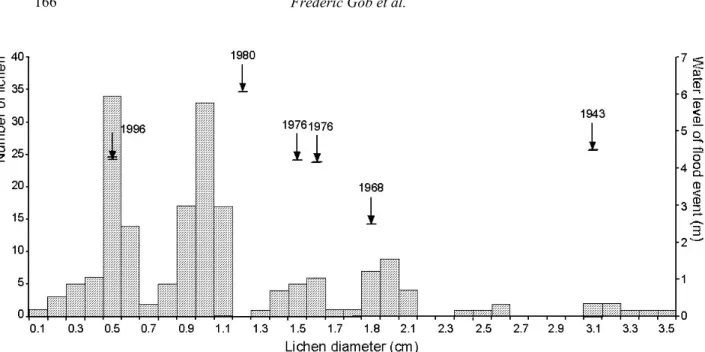
Figure

Documents relatifs
· (ed) Nqturalistic Studies of Nonhuman Primates. Effect of Familiar Behavior of Young Children.. A Study of the Dominative. ssive Behavior of Eight. Preschool
In addition to being a statutory requirement, periodic reporting is a means to assess the general implementation of the Convention by States Parties, evaluate their capacities
Thus semantic connection should replace semantic value as the principal object of semantic enquiry; and just as the semantic evaluation of a complex expression is naturally taken
If the above functions are known, both the mean values of the bending moment and the bending moment squared can be predicted based purely on the ship's heave and pitch
[r]
reb ospedive), opa ational definitions used to define dysphagia, 11 et1 aodology, such as techniques to evaluate the PI ese11e2 of dysphagia (e.g. bedside swaiiOYJing
- In-vivo: Students enrolled in a course use the software tutor in the class room, typically under tightly controlled conditions and under the supervision of the
These three preventive approaches to health problems are interdependent and fall within the more general mandate of training and education that each school is expected to carry
