AIG-11
Applied Isotope Geochemistry
Conference
September 21
stto 25
th2015
Orléans, France
Field trip
September 23
rd2015
The Fontainebleau Sandstone:
bleaching, silicification and calcite precipitation
under periglacial conditions
Médard Thiry Romain Millot Christophe Innocent Christine Franke Référence : N° rapport : RS150901MTHI Centre de Géosciences
Ecole des Mines de Paris, Fontainebleau, France
To cite this paper:
Thiry M., Millot R., Innocent C., Franke C., 2015, The Fontainebleau Sandstone: bleaching,
silicification and calcite precipitation under periglacial conditions, Field trip guide, AIG‐11, Applied Isotope Geochemistry Conference, September 21st to 25th 2015, Orléans, France
Scientific Report N° RS150901MTHI, Centre de Géosciences, Ecole des Mines de Paris, Fontainebleau, France, 26 pages.
Program
8h30 Departure Orléans by bus 10h30 Darvault, Bois de l’Abbesse sand pits, nice exposure of white sandstones interspersed with quartzite pans. After a short walk through the forest, you will discover spectacular scenery with sculptural and phantasmagorical rocks … eagle‐, horse‐like … take your camera! 12h30 Lunch at Barbizon. Charming village at the edge of the Fontainebleau Forest where artists gathered during the second half of the XIXth century, making nature the subject of their paintings. Among them were members of the Barbizon School of landscape painters (Millet, Corot, Rousseau, Daubigny, …) and impressionists (Monet, Renoir, Sisley, …). Take time to stroll through the village. 14h30 Château de Fontainebleau. Since 1981 on Unesco's World Heritage list, the Palace was one of the French kings favourite residence for eight centuries. The visit includes the famous horseshoe‐shaped staircase, the Galleries, the Apartments, the Chapel and the gardens. Alternatively, if some ones would like to see the historical site of the Calcites of Fontainebleau (the Crystal's Cave) , it will be possible to make an arrangement for those. 19h30 Back in OrléansSubject/content of the field trip
It will be show that the typical Fontainebleau Sandstone facies are in fact secondary facies, developed post‐deposition, and related to surface exposure of the formation. Quartzite pans, white sands, and even the mineralogical composition are related to subsurface (groundwater) alterations connected to geomorphology and result from exposure during the last glacial periods.
The Fontainebleau Sandstone example is extremely spectacular. Yet, such alteration features also exist in many other formations and may extent to 50‐100 m depth. One has to be attentive to recognize them. The goal of the field trip is to bring insight into what is related to primary and to secondary processes in the outcropping formation. This is of prime/particular importance for better understanding of the geology of the Fontainebleau Sandstone … and the geochemical processes that led to make up theses exceptionally pure sandstones mined to be used in all high quality and luxury glass manufactories throughout Europe. and supply guides for prospecting such sand ores. But in a general way, when such alteration happen, it is essential to recognize them before any geochemical study because interpretations, in particular isotopic interpretations may completely diverge as a primary or a secondary hypothesis is envisaged for some facies … like marine deposits vs groundwater precipitation, dry and warm vs glacial climates, sedimentary deposition vs acidic leaching, etc.
Corot, 1831, Chaise‐Marie quarry, Fontainebleau, Museum of Ghent (Belgium)
Jean‐Baptiste Camille Corot, a landscape painter from the 19th century and one of the founders of the School of Barbizon, liked to show small‐sized individuals in his paintings to contrast with the greatness of nature. The painting is said to represent two women collecting firewood (Daix, 1998). However, the right part of the picture is apparently unfinished and on closer inspection the scene is quite different. Here, the quarry being excavated with a wooden retaining structure under the surficial sandstone boulders. In the middle of the painting, a man seems to be buried under the quadrangular block and stretches his arm out for help. To the right one could see an unfinished silhouette of a women who pours white sand clearings from a wooden bucket and the wood gleaners collect long sticks to make a stretcher (?). This interpretation apparently show a snapshot of workplace accident in the Chaise‐Marie quarry!
As usually in Corot’s paintings, the mineral elements are particularly well represented: angular quartzite blocks in the quarry, rounded quartzite domes with basal flaring at the outcrop, and podzolic soils that infiltrate along vertical structures. Indeed one of the first pedologists ! to notice such details.
Field trip guide ‐Fontainebleau Sandstone – September 23 2015 1
The Fontainebleau Sandstone: bleaching, silicification
and calcite precipitation under periglacial conditions
Field trip guide
Médard Thiry(1), Romain Millot(2), Christophe Innocent(2), Christine Franke(1)
(1) Centre de Géosciences, Mines‐ParisTech, 35 rue St Honoré, 77305 Fontainebleau (2) BRGM / MMA‐ISO, 3 avenue Claude Guillemin BP 6009 ; 45060 Orléans cedex 2 medard.thiry@mines‐paristech.fr
1 "Classical" geological data
The Fontainebleau Sandstone is of Stampian age (early Oligocene or Rupelian), and comprises a 50 to 60 m thick fine grained and well sorted marine sand facies that is overlain by an aeolian dune sequence (Dollfus, 1911). The sedimentary structures show two successive successions from shore to foreshore facies and subsequent aeolian deposits (Fig. 1). These aeolian deposits form parallel curved beach‐ridge dunes of about 10 to 20 m height and over at least 100 km length (Dollfus, 1911; Alimen, 1936; Fig. 2). These successive sequences are interpreted as response of the sand body on rapid deepening process related to relative sea‐level changes (Cojan & Thiry, 1992; Delaye‐Prat et al., 2005).
Figure 1 – Typical vertical sequence of the Fontainebleau Sandstone formation. Two sequences can be recognized, each of them being characterized by an overall coarsening‐up in grain size in correspondence to the evolution
of a prograding sand body.
AIG‐11 ‐ Applied Isotope Geochemistry Conference, September 21 to 25 2015, Orléans, France
2
Figure 2 – The parallel NW‐SE ridges are consolidated by quartzite pans and correspond to aeolian paleo‐ morphologies that were formed during the northward regression of the Stampian sea. The red rectangle gives the limits of the detailed map in Fig 3. Modified after Alimen, 1936.
The uniqueness of the Fontainebleau Sandstone lies in the fact that very tight quartzite lenses "float" within unconsolidated sand bodies and that silicification preferentially affects the paleo‐dune ridges at the top of the formation. (Fig. 2 & 3).
Figure 3 – Paleo‐dune ridges topped by quartzite pans and brought in relief by erosion of the sand in the Western part of Fontainebleau Massif. The major ridges have a spacing about 1 km. Map after Ellenberger (1984).
The frequent coincidence between quartzite pans and paleo‐dune ridges led Alimen (1936) to the interpretation that the sandstone silicification was concomitant with the dune formation and the deposit of the Etampes Limestone that covers them. The silica would have been concentrated by evaporation in the capillary fringe above the groundwater that is contained in the dunes (Fig. 4). The silicification would therefore have occurred after formation of the dune ridges and before the deposition of the Etampes Limestone formation. Figure 4 – Schematic sketch of the development of the quartzite pans at the top of the dune ridges of the Fontainebleau Sandstone (after Alimen, 1936). According to this model, the quartzite developed before the burial of the dunes by the Etampes Limestone.
Field trip guide ‐Fontainebleau Sandstone – September 23 2015
3
After further reflexion, the "dune" model of Alimen (1936) raises several questions:
1) How to explain the formation of thick quartzite pans, since from the onset of the silicification porosity is reduced and evaporation potential decreases completely; 2) The model also conveys a geochemical contradiction, how would evaporation of
carbonated waters from inter‐dunal lakes lead to silica precipitation;
3) Quarries show superimposed quartzite pans, even cemented marine sands (Fig. 5), implying successive emersion episodes for which there is no record. 2 m 2 m 2 m
a
b
c
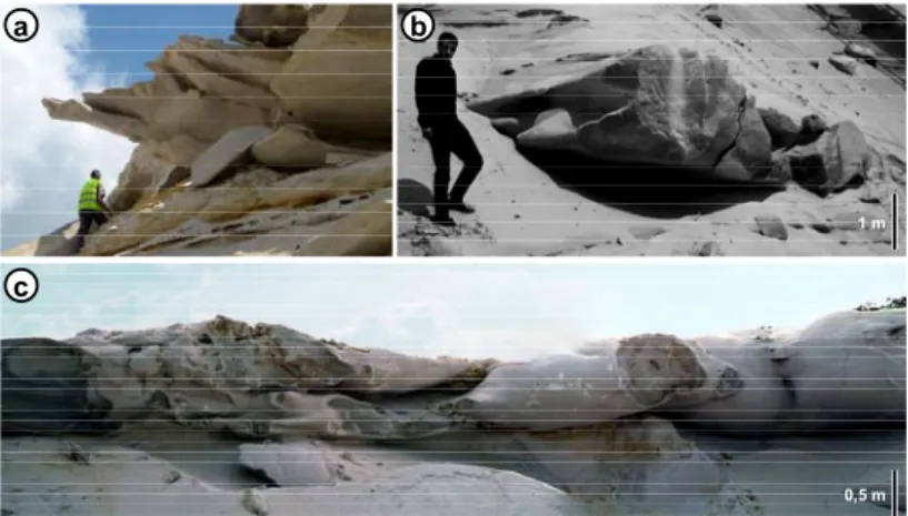
Figure 5 – Superimposed quartzite pans within the Fontainebleau Sandstone formation. (a) Quarry of Bourron‐Marlotte (77), view toward the SW in 1980, stack of 3 quartzite pans, the lowest one cements tidal deposits. (b) Quarry of Blomont les Roches (Larchant, 77), W working face in 1984, 4 superimposed pans merge together towards the left of the picture, note the size of the men standing on the lower pan.(c) quarry l’Huilerie (Chapelle‐la‐Reine, 77), W working face in 1995, 4 superimposed quartzite pans, among which one is tilted (unusual case). See locations on Fig. 6.
2 Recent data on quartzite formation
The above critical analysis of the dune‐related model of silicification showed that it was probably too simplified. This motivated us to make a review of the available drilling information.
2.1 Distribution of the quartzite
The inspection of 372 drill‐hole data sets, that were established on the Beauce Plateau (Fig. 6) and that reach the Fontainebleau Sandstone formation, revealed the scarcity of the cemented levels in these drill cuts (Thiry et al., 1988). Only 69 drill records (18% from the total number) encountered solid sandstone levels and not all of them are quartzite: 8 were identified as quartzite pans (without showing any reaction on HCl), 19 were cemented by calcite (positive HCl test), and 42 of the hard layers were without precision of their composition (no HCl test). Some rare drill‐holes, which indicate the presence of quartzite pans, are all situated near the edge of the plateau (less than 1 km from the outcropping sandstone). The calcareous indurated levels are present especially in the sector south of Fontainebleau.
Therefore, drill‐hole data highlight that the abundant silicified bodies that crop out on the edges of the Beauce Plateau and in the adjacent valleys do not extend with depth beneath the limestone cover, where the sandstone is devoid of silicified bodies (Fig. 7). The quartzite pans are restricted to the vicinity of the outcropping sandstone and this excludes the possibility that quartzite formed before the deposit of the limestone cover.
AIG‐11 ‐ Applied Isotope Geochemistry Conference, September 21 to 25 2015, Orléans, France
4 Figure 6 – Geological map of the southern Paris Basin, showing the location of the drill‐holes and occurrence of the encountered hard levels.
Figure 7 –Schematic geological section through the Beauce Plateau. Quartzite pans are limited to the outcrop zone of the sandstone. The size of the quartzite lenses (black wedges) is exaggerated for better legibility of the drawing.
This unusual distribution of the silicified bodies along slopes is also observed on the scale of the sand quarries. For the last 30‐40 years, environmental conservation efforts led the quarrying operations to develop towards the plateaus to be less visible in the landscape. This revealed the systematic decrease of the silicified bodies towards the deeper part of the plateaus and their absence in the extension of the quarries (Fig. 8), resulting in a systematic disappearance of the silicified levels in a 250 to 500 m distance from the valley flanks.
Field trip guide ‐Fontainebleau Sandstone – September 23 2015
5
Figure 8 – Synthetic section showing the arrangement of the silicified pans at the outcrop and those observed during the mining activity in the sand pit of Bourron‐Marlotte (south of the Fontainebleau Massif). Compare also with picture Fig. 5a.
2.2 Model of groundwater silicification
If the quartzite pans had formed in the dune landscape during the Stampian, before the deposit of the Etampes Limestone cover, their distribution should be independent of the present landscape and more or less homogeneous beneath the limestone plateau. The peculiar spatial distribution of the quartzite leads to the following two hypotheses:
1) The strong relationship of the quartzite pans with the actual geomorphology suggest that silicification occurred relatively recently in the outcrop zones of the Fontainebleau Sandstone, after the Plio‐Quaternary incision of the plateau and valley structures ; 2) The arrangement of the quartzite in sub‐horizontal pans suggests that their genesis is
controlled by groundwater table related formation processes, thus every quartzite level would correspond to a paleo‐ groundwater level.
Taking the geometrical constraints into account we propose a silicification model in the groundwater outflow zone near the sandstone outcrop areas (Fig. 9):
1) quartzite forms by silica precipitation in the zone of groundwater outflow;
2) every erosion resumption lead to lowering of the groundwater table, and the formation of a new quartzite pan occurs during the subsequent period of landscape stability; 3) the discontinuous aspect of silicification with superposition of separate quartzite pans is
related to the periodicity of valley down‐cutting, the pulses in erosion periods being controlled by the rupture of downstream "dams" or by climate change;
4) the upper quartzite pans are the oldest and the lower ones the youngest.
Figure 9 – Schematic model of successive cycles of groundwater related quartzite formation in the Fontainebleau Sandstone. The thickness and the slope of quartzite pans are exaggerated for better legibility of the drawing.
Remains the question of the preferential silicification of the dune ridges. Due to their fine granulometric sorting and their depletion in clay, the dune sands have a high permeability that favours groundwater flow. Furthermore, during valley incision, the groundwater discharges
AIG‐11 ‐ Applied Isotope Geochemistry Conference, September 21 to 25 2015, Orléans, France
6
preferentially through these permeable pathways, which are the first ones touched by erosion beneath the limestone cover. These arrangements may also favour the preferential silicification of the dune sand ridges.
Nevertheless, silicification can only develop if silica supply is sustained (Thiry et al., 1988). Indeed, approximately 600 kg of silica is necessary to cement one m3 of unconsolidated sand with an initial porosity of 25 %. Assuming that the groundwater contains ~15 ppm of SiO2 and that
10 ppm are thus available to feed the precipitation of quartz (with regard of the 5 ppm solubility equilibrium of quartz), 60 m3 of water would be needed in order to cement one dm3 of quartzite,
and 120 000 000 m3 of water to form a quartzite pan of 100x30x2 m3. If we consider that this water corresponds to an average spring outflow of 6 m3/h, the cementation can potentially form in about 2 000 years.
2.3 Growth of the quartzite lenses
The most outstanding feature of the quartzite lenses is the contrast they show between the very hard, tightly cemented quartzite and the loose and permeable embedding sands. Boundaries are always sharp and the transition from the sand towards the quartzite occurs generally with a friable rim, which is usually less than 1 cm thick. This pattern raises the question of the growth mechanism of the lenses. If the cementing silica was provided by solution, the lenses cannot be formed in one step. As soon as the sand is partly cemented, the porosity decreases and the feeding solution will take a different pathway so that a tight cementation cannot be obtained. Progressive centrifugal growth of the silicified bodies, such as concretions, may rather explain the observed arrangement. Detailed morphological and petrographical observations enlighten this hypothsis.
Morphology of the quartzite lenses
Most of the silicified bodies are flat lying and show a great variety of shape and size. The quartzite morphologies are always smoothly rounded, metre‐long, frequently showing spindle‐like or aircraft fuselage/wing‐like shape, with one well rounded and one thinner edge (Fig. 10a & 10b). Forms that are more complex exist and may result from a coalescence of neighbouring bodies, but they always remain streamlined (Fig. 10c). A striking feature of most of the quartzite lenses is that they predominantly extend towards the outcrop fringe or the neighbouring valley. These morphologies, although larger, are similar to those of the elongated and oriented calcite concretions thought to have precipitated in the saturated zone parallel to the paleo‐groundwater flow direction in clastic aquifers (McBride & Parea, 2001). The characteristic shapes of the quartzite lenses are clearly link to the silicification along paleohydrological pathways.
In addition, the outer fringe of the quartzite lenses frequently has a botryoidal or "custard‐ like" aspect (Fig. 11a). These features are caused by a succession of silicified layers suggesting a centrifugal growth of silicification. Generally, there is no internal structure to the sandstone, but sometimes tightly cemented fringes are visible within the silicified lenses (Fig. 11b & 11c). This confirms that the lenses grew by accumulation of successive silicified layers. Silicification progresses around a core by cementation of successive layers that overlap in a discordant way. The spatial arrangements of these botryoidal features record the flow pattern of the feeding solution.
Field trip guide ‐Fontainebleau Sandstone – September 23 2015 7 0,5 m c a b 1 m Figure 10 – Morphologies of the quartzite lenses. (a) Outcrop of very flat lenses ending in spindle‐like shape in the direction of the current dry valley, sand pit Butteaux (Chapelle‐la‐Reine, 77). (b) Airfoil‐like shaped morphology suggesting the paleo‐hydrological flow direction towards the camera, in direction of the recent valley, sand pit Bonnevault (Larchant, 77). (c) Coalescent lenses with hydrodynamic shapes, streamlined towards the neighbouring dry valley, sand pit l’Huilerie (Chapelle‐la‐Reine, 77).
Figure 11 – Internal structures of the silicified bodies. (a) Botryoidal or "custard‐like" aspects of a silicified lens. These features result from successive silicified layers that point to centrifugal growth of the silicification, sand pit Bonnevault, Larchant (77). (b) Internal zones underlined by tightly cemented fringes that indicate successive stages of silicification, sand pit Villejust (91). (c) Idem b, sand pit les Gondonnières (Larchant, 77).
AIG‐11 ‐ Applied Isotope Geochemistry Conference, September 21 to 25 2015, Orléans, France
8 Petrography of the quartzite
The quartzite lenses are tightly cemented with a secondary quartz content varying between 30 and 35% leaving a residual porosity which may be as low as 2% (Cooper et al., 2000; Thiry & Maréchal, 2001; Haddad et al., 2006). Cathodoluminescence analyses of the quartzite shows detrital grains with two main habits in the quartz overgrowths (Fig. 12):
1) Sub‐euhedral quartz overgrown by successive dark and clear stripes (Fig. 12a). The overgrowths are sutured along straight lines that converge towards triple junction points, leading to polygonal contacts. These are syntaxial overgrowths around the detrital grain.
2) Isopachous quartz layers surrounding the detrital grains (Fig. 12b). The coatings are alternately bright and non‐luminescent. These isopachous layers cannot be linked to the quartz overgrowths, which would rather lead to euhedral shapes. Instead, they suggest the presence of amorphous or poorly ordered silica deposits that recrystallized later to quartz out from the detrital core.
These two cement varieties may coexist in the same quartzite lens. Sometimes they are arranged in a sequential fashion. The different cement types probably reflect changes in the silicification conditions, in particular in saturation state of the solution with respect to the quartz, that may occur periodically or/and laterally along the solution pathway.
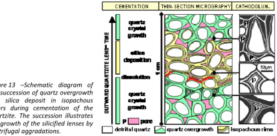
Figure 12 – Cathodoluminescence images of the quartz cement in the quartzite. (a) syntaxial overgrowth, (b) isopachous concentric layers filling the pores. (1) detrital quartz grain, (2) quartz layers, (3) residual pore. 2 1 3 b a 1 2 100 µ m 100 µ m The detailed study of the various cement types by EBSD (Electron Back‐Scatter Diffraction) allows specifying that the concentric isopachous quartz layers are microcrystalline, showing variable orientations with regard to the detrital grains (Haddad et al., 2006). This indicates that the concentric layers are not formed in crystallographic continuity with the substratum (non‐syntaxial) but show zonal arrangements that indicate that the final stage of the growth was not random. Sequential growth The various types of observed silica cement can coexist in a single silicified lens. The sub‐ euhedral overgrowth may be covered by silica deposit, which may be succeeded again by euhedral overgrowth (Fig. 13). Dissolution features are also visible in some places between the successive silica deposits. Where developed, these microscopic sequences correspond to the macroscopic ‘‘layers’’ or fringes observed in some quartzite bodies (Figs. 11). They show the alternation of
Field trip guide ‐Fontainebleau Sandstone – September 23 2015
9
cementation periods by quartz overgrowth, periods of amorphous silica deposit, and occasionally, periods of silica dissolution (Fig. 13).
The succession of these petrographic facies points to the variable physico‐chemical conditions during the cementation of the quartzite, particularly the variation of the dissolved silica concentration and the degree of oversaturation with respect to quartz.
1) Amorphous or weakly crystallized silica was precipitated frm strongly oversaturated water as result of relatively fast changes of the physical conditions of the environment. 2) Quartz was precipitated from weakly oversaturated and mineralized water, close to
quartz solubility equilibrium.
3) Previously precipitated silica was dissolved by diluted water (infiltration?).
Figure 13 –Schematic diagram of the succession of quartz overgrowth and silica deposit in isopachous layers during cementation of the quartzite. The succession illustrates the growth of the silicified lenses by centrifugal aggradations.
3 Variability of the sandstone facies (oxidation and bleaching)
The Fontainebleau Sandstone was classically thought to be white and very pure sand deposits. From the 1970’s, the increase of drill‐holes and the expansion and deepening of the sand pits showed that these sand facies are much more varied, with in particular dark, glauconitic, organic‐ and pyrite‐rich sands beneath the plateaus. The recognition of the black facies was previously "unexpected" with only white and oxidised facies known at the outcrop.3.1 Regional facies distribution
Black sands were recognized in at least 3 areas in the southern Paris Basin: beneath the Plateau of Trappes, on the northern slope of the Remarde anticline and at Angerville and Puiset in the central part of the Beauce Plateau (see map Fig. 6). Sections and drill‐holes of the Plateau of Trappes exemplify the facies variations and their mutual relations (Fig. 14). The dark facies are less important in thickness in the drill‐holes near the edge of the plateau, where they are replaced by ochre and red oxidized facies. At the outcrop and in small quarries at the valley flanks, the sands are essentially clear, beige to white, with ferruginous stripes and some ghosts of decalcified and ferruginized shells.
There are lateral facies changes: the oxidized, white, beige or red facies result from the alteration of the dark facies, which correspond in fact to the primary facies of the sand deposit. Sands above the groundwater table were oxidized, while those permanently beneath the groundwater were preserved.
AIG‐11 ‐ Applied Isotope Geochemistry Conference, September 21 to 25 2015, Orléans, France
10
Figure 14 – Geological section of the Plateau of Trappes, South of Paris showing the distribution of the primary black and secondary oxidised facies of the Fontainebleau Sandstone. The boundary between dark and oxidised facies corresponds approximately to the groundwater level.
3.2 Local facies distribution
At the beginning of the quarrying activities, all sand pits were quite limited to the immediate edge of the plateaus and extracted exclusively white, very pure sands of exceptional quality (> 99.5 % silica), containing no feldspars or clay minerals and only few mica, for the glass industry. Since the 1970’s the sand pits were deepened and extended further into the plateaus. With this ongoing spatial extension of the pits, beige, ochre and even reddish sands appeared systematically, next to greenish glauconitic sands towards the bottom of the pits (Fig. 15). These different sand facies are organized according to a profile of about 20 m in thickness. Figure 15 – Synthetic sketch of the alteration profiles exposed in the sand pits. The white facies occupy the entire profile in the neighbourhood of the outcrops; the ferruginous and glauconitic facies are only present further away from the outcrop areas and gradually rise in the section beneath the plateau.
Flint pebbles give further detailed information on the alteration process. They are of rounded shape and show a translucent fracture surface at the base of the formation, whereas they become altered and friable in the upper part of the section where the white sand occurs (Fig. 15). At places where the flint pebbles are embedded in the quartzite lenses, they have kept their original rounded shape and translucent fracture surface. The flint pebbles in the white sands have apparently been weathered subsequently to the formation of the quartzite lenses. In addition, numerous sections show "ghosts" of decalcified shells and sometimes residual fossil lenses.
Flint pebble, carbonate, and clay mineral evolution in the white sands point to an alteration by dilute, relatively acid waters. Alteration of glauconitic sands into ferruginous sands
Field trip guide ‐Fontainebleau Sandstone – September 23 2015
11
provides evidence for less acidic waters. To understand the mechanisms of these alterations, it is necessary to consider (1) water infiltration as in a soil profile to explain the vertical alteration profile and (2) groundwater flow towards valleys as highlighted by the distribution and shape of the quartzite lenses.
3.3 Regional sequence of alteration
Geochemical modelling of the hydro‐chemical transfers in the Beauce groundwater allows specifying the mechanisms of the sand alteration (Bariteau & Thiry, 2001). The groundwater‐ aquifer system of the Beauce is divided into several compartments, which progress from soil infiltrations to outflows in the valleys (Fig.16).
1) The infiltration waters that recharge the groundwater are oxygenated. On the Beauce Plateau, the infiltration water (1a) is calco‐carbonaceous whereas at the edge of the plateau, near the sand outcropping areas, the infiltration water (1b) is enriched in organic acids and only weakly mineralized. Flowing northwards, as the calcareous cover thins out, the infiltration water is less and less mineralized and therefore dilutes the more mineralized groundwater. Thus, towards the outlets (valleys) the groundwater is more and more diluted and acidic, and therefore more "aggressive" with respect to the aquifer.
2) In the South and in the centre of the Beauce Plateau, the groundwater is situated in the weakly karstified Beauce Limestone, saturated with regard to calcite and remains oxygenated even in depth.
3) In some parts of the plateau, the groundwater is incorporated in the dark coloured Fontainebleau Sandstone facies, sulphurs are oxidised, groundwater becomes slightly acidic and iron oxide is locally remobilised.
4) At the border of the plateau, in the neighbourhood of the outcropping sandstone, the groundwater is contained in ochre or light Fontainebleau Sandstone facies, is highly diluted by the recharge water and the sandstone becomes fully bleached. Figure 16 – Schematic arrangement of the various sandstone facies and quartzite lenses with regard to the incision of the Fontainebleau Sandstone formation and the hydrology of the Beauce groundwater. The groundwater flow through the sands is responsible for the successive alterations. The geochemical imbalance between groundwater and the sandstone minerals results in mineralogical alteration and mineralization of the groundwater (Bariteau & Thiry, 2001). The alteration continues throughout groundwater flow, on one hand because of the very slow dissolution kinetics of silicate minerals (clay minerals and feldspars), and on the other hand because the groundwater is further diluted all along its flowpath.
AIG‐11 ‐ Applied Isotope Geochemistry Conference, September 21 to 25 2015, Orléans, France
12
Oxidation of the black sands (organic‐ and pyrite‐bearing) is the first and fastest alteration step. It leads to Fe‐enriched and acidified water that is aggressive with respect to the silicates. The alteration continues in the oxidized sands, with alteration of the primary silicates (feldspars, mica and glauconite) into smectite and kaolinite. The final leaching step of the oxidized sandstone by weakly mineralized and acidic infiltration water leads to the formation of the white sandstone facies; here the smectite is altered into kaolinite, which in turn is itself altered, so that only the quartz grains remain. Throughout its flow, the groundwater is almost in equilibrium with the carbonates, which in turn are only slowly dissolved. However, carbonate dissolution is strongly increased/accelerated in the white sandstone outcropping zones.
The geochemical simulations explained above have been considered within the constraints of the current climate conditions (Bariteau & Thiry, 2001). Nevertheless, if we consider a cold, boreal climate, the soils would be podzolic, with a high organic content and raised acidity. The infiltration water would be more aggressive under that boreal climate scenario, and in particular, the sandstone in the neighbourhood of the outcrops would be bleached more rapidly than it would be under recent climate conditions.
4 The Calcites of Fontainebleau
The “Belle‐Croix sand calcites” were mentioned in relatively early geological publications (Lassone, 1775 & 1777). Any respectable mineralogical collection must therefore have an example of it. Searching the World Wide Web reveals that all American mineralogical museums have a piece of this "French super classic of acute rhombohedral crystals". The "bellifontain" deposits are apparently unique, there are very few other deposits of sand calcite and none of them show such large and accurate crystals forms.
In contrast, only very few recent publications are dedicated to the Calcites of Fontainebleau, most notably a historical review (Gaudan, 2004). Information on the sand calcites of Fontainebleau and from elsewhere in France, Europe and the world are available on the World Wide Web (Löffler, 1999, 2011).
4.1 Habits of the Calcites of Fontainebleau
Crystals
The crystals are always of (022ˉ1) rhomboedral form, so‐called inverse rhombs, that are sometimes single crystals, but generally are grouped in aggregations (cristallarias) which may reach several decimetres in size (Fig. 17a & 17b). The crystals which form these cristallarias have perfect forms and show interpenetrations of several individuals with parallel axes giving radial sheaf‐like arrangements (Fig. 17c). Translucent, cm‐sized euhedral calcite crystals are sometimes associated with the previously described sand calcite type (Fig. 17d).
Nailed quartzite
Centimetre‐ to millimetre‐sized granules, sometimes clustered together, are often situated at the top of the upper quartzite pan in the quarries (Fig. 17e). These correspond to the nailed quartzite pans described by Janet (1894).
Concretions
Sand calcite spherulites are frequent in the white sands, sometimes associated with the sand crystals. Their size varies from decimetre concretions to millimetre granules (Fig. 17f). The concretions are often zoned, with a relative "smooth" surface, or show radially arranged small rhomboehedral calcite crystals. They often cluster together in horizontal layers or form large pluri‐ metric sized accumulations (“Roche à Boule” and “Rocher le Carrosse”, in the Fontainebleau Forest).
Field trip guide ‐Fontainebleau Sandstone – September 23 2015
13
4.2 Petrography
The spherolites and the cristallarias are of poecilitic texture characterized by large calcite crystals (up to several centimetres) containing quartz grains of the host sandstone, but without any quartz overgrowth. Sand crystals and spherolites differ in size of the calcite crystals that are generally smaller in the spherolites. The calcite proportion of the sand crystals varies between 20 and 35%, corresponding to the porosity of a weakly compacted sandstone. The calcites do not have Mg substitution according to X‐ray diffraction analysis. Figure 17 – Calcites of Fontainebleau, (a) sheaf‐like rhombs (Grotte aux Cristaux, Fontainebleau Forest, 77), (b) rhomboedral crystals superimposed on cristallarias (sample. 8940, sand pit Gondonnières, Larchant, 77), (c) muddled rhombs (sample 8931, La Garenne, Darvault, 77), (d) translucent crystals (sample 8787, sand pit Gondonnières, Larchant, 77), (e) quartzite body "nailed" with small cristallarias (sample 8943, sand pit Gondonnières, Larchant, 77), (f) sand calcite spherulites (sample 8604, sand pit Rozet‐St Albin, 02). Sample numbers correspond to samples dated (compare Tab. I).
AIG‐11 ‐ Applied Isotope Geochemistry Conference, September 21 to 25 2015, Orléans, France
14 4.3 Age determinations 14 C and U‐Th datings of 19 sand calcite samples from various sandstone formations of the Paris Basin all result in Pleistocene ages. The datings group together embracing 4 periods that all coincide with cooling periods of the glacial stages (Tab. 1 & Fig. 18). These datings evidence that calcite precipitation is linked to climate and depth in the sandstone sections. The youngest ages (< 20 000 years) match with particular spherolites occurring at the upper surface of quartzite pans. No age distinction between the euhedral and the spherolitic sand crystals was detected.
Table 1– Radiometric datings of the sand crystals and spherolites from various Tertiary sandstone formations in the Paris Basin. 14C datings (ANU=Australian National University, Poz=Poznan Radiocarbon Laboratory) and U‐Th datings (BRGM laboratory). The Poligny samples evolved obviously in an open system and the 300 ky hypothesis relays on the fact that the best‐preserved calcite samples have U‐Th ratios close to those of Puiselet (Innocent, 2011).
host fm. sampl. N° 14
C lab.ref. localisation description age 14
C age U/Th
8609 Poz-24382 Mont Sarrasin, Puiselet, 77 cristallaria (center/base) >50 000 8609E Poz-29892 Mont Sarrasin, Puiselet, 77 cristallaria (outer crystals) >50 000
323 000 +/- 20 000 8787 Poz-29896 Gondonnières, Larchant, 77 translucent rhombs >52 000 400 000 ? 6790 Poz-49823 Butteaux, Chapelle/Reine, 77 translucent crystal sheaf >45 000 194 000 6793 Poz-24383 Bonnevault, Larchant, 77 cristallaria 51 000 ± 5 000 8931 Poz-49825 Darvault, 77 - La Garenne cristallaria ( 5 cm) 49 000 ± 3 000 8930 Poz-49824 Roche Eponge, Fbleau, 77 cristallaria ( 2 cm) 45 000 ± 2 000 8933 Poz-49827 Grotte Cristaux, Fbleau, 77 cristallaria within quartzite 44 000 ± 2 000 8942 ANU-6639 Grotte Cristaux, Fbleau, 77 cristallaria in quartzite 33 630 ± 640 8940 ANU-6637 Gondonnières, Larchant, 77 cristallaria 32 950 ± 5 200 9003 Poz-73201 Cuvier Chatillon, Fbleau, 77 sperolites ( 4-5 cm) 32 900 ± 500 8605 Poz-24379 Carosse, Fbleau, 77 sperolites ( 1-2 cm) 31 700 ± 300 8941 ANU-6638 Gondonnières, Larchant, 77 cristallaria 26 880 ± 1 140 8965 Poz-73200 Roche à Boule, Montigny, 77 sperolites ( 2.5 cm) 25 100 ± 210 Stampien
8943 ANU-6636 Gondonnières, Larchant, 77 Granules, nailed quartzite 14 180 ± 330 8932 Poz-49826 Crepy-en-Valois, 60 granule cluster 46 000 ± 2 000 8603 Poz-24376 Grisolles, 02 cristallaria ( 5 cm) 39 000 ± 700 8601 Poz-24375 La Croix-sur-Ourq, 02 granules ( 5 mm) cluster 9 750 ± 50 Auversien
8604 Poz-24378 Rozet-St Albin, 02 spherolites ( 1-5 cm) 7 250 ± 40 8607 Poz-24380 Montbron, Sourdun, 77 fibrous septaria 47 000 ± 2 000 8544 Poz-24372 Glandelles, Poligny, 77 calcareous sandstone >48 000 8593 Poz-24373 Glandelles, Poligny, 77 cristallaria ( 2-4 cm) >48 000
Sparnacien 300 000
(hypothesis) Thanétien 5946 Poz-29890 Rollot (80) spherolites ( 1-3 cm) 44 000 ± 1 400
VOSTOK 150 0 300 450 ka Petit et al., 1999 δ18O NGRIP 10 20 30 40 50 0 ka Obrochta et al., 2014 cristallarias spherolites granules Figure 18 ‐ Correlation of age estimations of the sand calcite in comparison to the time calibrated δ18O record of the VOSTOK 3 and NGRIP 4 ice core 18O isotope curves. The sand calcites are bound distinctively to the cooling periods of the last four glacial periods. Analytical errors present < 10%.
Field trip guide ‐Fontainebleau Sandstone – September 23 2015
15
4.4 Glacial or cryogenic calcites?
The Calcites of Fontainebleau and similar concretions have to be compared with cryocalcites from recent cold areas (Arctic, Antarctic and high altitudes) and those formed in glacial paleoenvironments during the Quaternary (Richter et al., 2009, 2010; Zak et al., 2012). Recent studies were interested in these calcites to use them as a proxy for the depth and estimation of the extension of permafrost during glacial periods.
Cryogenic calcite precipitation results from water freezing which excludes the species in solution (rejection of salts) and thus concentrates the solutions until their saturation with respect to calcite solubility. This cryogenic model cannot be applied to the Calcites of Fontainebleau that develop within an aquifer. Indeed, pore water freezing would not allow precipitation of large calcite cristallarias. The mass balance between the amount of Ca and CO3 needed to form the
calcites precipitated can be satisfied solely by a large water volume and thus implies a renewal of the solutions by flow.
Spatial and morphological arrangements of the sand calcites show that their formation is connected to infiltration of surface water towards the water table. During the Pleistocene glacial periods, and more precisely during the cooling periods, a distinct temperature gradient was established between the surface water (near 0°C) and the deeper realm (aquifer and groundwater) where temperature changes are retarded with respect to the immediate cooling at the surface. Under these conditions, the temperature of the subsoil at 10 or 20 m depth may have remained equivalent to its current temperature around 12°C.
Yet, CO2 and carbonates are more soluble in cold than in warm water. When the water in
equilibrium with the atmospheric CO2 warms up from 0 to 12°C it loses approximately 1/3 of its
dissolved CO2 and more than 30 % of the dissolved calcite precipitates (Fig. 19). During cold
periods, the infiltrating water warms up in the subsoil and CO2 degasses subsequently leading to
calcite precipitation (Fig. 20). Therefore, the permafrost thickness has to be limited and discontinuous to still allow local infiltration. This limitation provides the link with the cooling periods.
Figure 19 ‐ Variation in CO2 solubility with temperature (Bethke, 2002). The solubility of CO2, and thus of calcite, decreases to more than one third of its value between 0 and 12°C. The non porous quartzite is more conductive of heat/cold than the sandstone. Therefore, the thermal gradient is steeper at the top of the quartzite pans. This may explain the formation of calcites at the upper surfaces of the nailed quartzite pans (Thiry et al., 1984). Thus, the younger calcites were able to precipitate under a reduced cover (3‐7 m), without any need of an extreme cold period. 0.4 1.0 0.8 0.6 1.2 0 10 20 30 temperature 40 °C CO2 (aq) (mol/L)
AIG‐11 ‐ Applied Isotope Geochemistry Conference, September 21 to 25 2015, Orléans, France
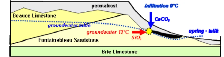
16 infiltration 0°C -5 0 15°C mean temperature geothermal influx CaCO3 CO2 limestone sandstone water table discontineous permafrost spherolithes cristallarias degassing precipitation Figure 20 – Conceptual model of sand calcite precipitation. The temperature contrast at the base of the permafrost front causes the degassing of the infiltration water that in turn leads to the precipitation of the dissolved carbonates.
4.5 Isotopic composition
The stable isotopic composition of the bulk samples shows variable δ13C values ranging
between ‐5 and ‐12‰ and δ18O values ranging between ‐3 and ‐6‰. These results are similar to those of karst speleothems of central and western Europe (Couchoud, 2006; Zak et al., 2012) and very different from cryocalcites resulting from the oversaturation of freezing water (Richter et al., 2010; Zak et al., 2012).
A correlation exists between the δ13C composition and the depth at which the calcite
precipitated (estimated with respect to the present day depth beneath the overall plateau level). A light δ13C signature originating from organic carbon input is clearly restricted to shallow samples (Fig. 21a). Furthermore, the “younger” samples have a lighter δ13C signature, whereas the “older” samples show less influence of organic carbon (Fig. 21b). The younger and shallower calcite crystals are stronger influenced by organic carbon originating from the overlaying soils whereas the older and deeper crystals reflect the chemistry of the regional groundwater. Nevertheless, younger and older calcites may coexist in a section because the sedimentary cover has been eroded in between two stages of calcite crystallization.
The stable isotope results toile along two trends within a δ18O‐δ13C diagram (Fig. 21c).
1) The distribution along the positive slope of the diagram highlights an evolution from near‐surface samples precipitated from water enriched CO2 originating from organic
carbon towards deeper samples fed by the groundwater with less influence of organic carbon;
2) The distribution along the negative slope of the diagram is in agreement with the precipitation mechanisms. The lower δ13C values and higher δ18O values result from
kinetic isotope fractionation due to fast CO2 degassing and calcite precipitation. For a
given deposit, the values are dispersed along the negative slope of the axis due to changes of the precipitation conditions. There is also an evolution between the centre and the rim of a cristallaria corresponding to faster precipitation, with formation of multiple small crystals on the surface of the previous large single crystal in the centre of the cristallaria.
Field trip guide ‐Fontainebleau Sandstone – September 23 2015 17 R= 0.587 -10.00 -8.00 -6.00 -4.00 ‰ 13C 10 20 0 30 de pt h m a -5.00 -4.00 -3.00 ‰ 18O ‰ 13C Poligny 300 kyr
from core to external rim other sites Larchant ~ 30 kyr Puiselet 323 kyr -10.00 -8.00 -6.00 -4.00 -12.00 fast precipitation Rupelian quarries transluscent Rupelian subsurface Bartonian quarries depth c -10 -8 -6 -4 7 250 33 63 0 32 95 0 31 70 0 26 88 0 14 18 0 39 00 0 49 00 0 47 00 0 46 00 0 45 00 0 44 00 0 51 00 0 4 00 000 3 23 000 3 23 000 3 00 000 1 94 000 300 000 300 000 yr BP ‰ 13C ‰ 18 O b Figure 21 – Stable isotope composition of sand calcite, (a) correlation of δ13C with depth of the precipitation sites; (b) relationship between age and isotopic composition; (c) δ18O vs. δ13C diagram showing the dispersion of the values along the axes.
4.6 Mutual relationships between calcite and quartzite
Glandelles valley at Poligny (77)
South of the city of Nemours, in the valley towards Poligny (see map Fig. 6), sand calcites are associated with a quartzite pan covering a puddingstone of lower Eocene age and beneath an upper Eocene lacustrine limestone. The quartzite has an interpenetrated calcareous and silica cementation (Fig. 22a) and shows calcite cristallarias (diameter of 2‐5 cm), with some of them clearly included in the quartzite. Relationships are particularly spectacular when the calcite is dissolved and remains a hollow imprint in the moulding of the dissolved rhombs (Fig. 22b).
The silica cement is made of overgrown quartz grains as in the Fontainebleau quartzite. The calcareous cement is formed by centimetre‐sized calcite crystals enclosing non‐overgrown quartz grains. These cristallarias formed "freely" within the sandstone and subsequently the silicification moulded around them. Silicification postdates the calcites which have been dated to 300 000 years with an U‐Th isochron on 5 samples (Tab. 1). The silicification would thus date to the Riss glacial period or later.
Figure 22 – Quartzite with included calcite cristallarias (sand pit Poligny, 77), (a) interpenetrative calcareous and silica (in relief) cements. (b) imprint of a dissolved calcite cristallaria in the quartzite.
AIG‐11 ‐ Applied Isotope Geochemistry Conference, September 21 to 25 2015, Orléans, France
18 "Grotte aux Cristaux" in Fontainebleau
Calcite cristallarias are clearly observed in a quartzite lens near the “Grotte aux Cristaux” (crystal cave) in the Fontainebleau Forest (Fig. 23a) and crystal rhomb forms are moulded by the quartzite that supportts the crystal cave (Fig. 23b).
Two cristallaria sets in the quartzite have been dated: one from the quartzite lens described above (Fig. 29a) that resulted in an age of 44 000 years BP, and another taken from an old working face (approximately 50 m east of the previous one) that resulted in an age of 33 630 years BP. These datings show that the silicification of the Fontainebleau Sandstone is rather young, and consequently would have been formed relatively fast.
Figure 23 – Relationship between calcite cristallarias and quartzite at the historical founding site of the “Grotte aux Cristaux” (Fontainebleau Forest, 77).(a) calcite cristallarias set in a quartzite lens neighbouring the crystal cave. (b) silica cemented quartzite in the contact with the Calcite de Fontainebleau and revealing included rhomboedral geometries.
5 Periglacial
silicifications
In the groundwater silicification model related to valley incision (Thiry et al, 1988), the silica precipitation mechanism raised a problem. It had been proposed that the groundwater was over‐saturated with regards to the quartz (that is and remains true) and that quartz precipitation was triggered by a "catalyst" carried by the organic‐rich infiltration water which mixes with the groundwater (Thiry & Maréchal, 2001). This was only a hypothesis, but allowed testing of the hydrodynamic model and determining the time necessary to develop a quartzite pan. With the dating of the Calcites of Fontainebleau and their relation with glacial periods, the question of silica precipitation is renewed.
5.1 Precipitation mechanisms
Temperature acts in a very significant way on silica solubility. Quartz solubility decreases with decreasing temperature according to an exponential law (Fig. 24): it is decreasing more than half by cooling the solution from 25 to 12.5°C, and from 12.5 to 0°C. These temperatures are in the range that exists between the subsoil and the landsurface for cold climates. Thus, in cold periods, the silica in the groundwater may precipitate if the water cools significantly by getting closer to the landsurface. Various forms of silica, including opal, may precipitate along a sharp boundary between the cold subsoil and groundwater if cooling is rapid enough and the oversaturation is high.
Silica precipitation by cooling a solution is the most probable mechanism to explain silicification at or near the point of discharge of groundwater towards the valleys during glacial periods in the Paris Basin. If the temperature drop is slow, oversaturation remains low and there
Field trip guide ‐Fontainebleau Sandstone – September 23 2015
19
will be quartz precipitation and overgrowth. If the temperature drop is fast the "released" silica will not be "fully consumed" by the growth of the quartz, because the latter has very slow crystalline growth kinetics. There will be strong oversaturation of silica in the solution and thus precipitation of amorphous or cryptocrystalline silica forms in isopachous concentric layers, which later will re‐crystallize into quartz (Thiry & Maréchal, 2001).
Therefore, the quartzite sequences of cementation, with quartz overgrowth followed by isopachous silica deposit (Fig. 13) would correspond to temperature fluctuations or at least to fluctuations of the temperature gradient along the groundwater flow paths. The sequences of silica deposition would relate to climatic fluctuations, with respective deepening or rising of the permafrost front. The duration of these cycles remains to be investigated.
Figure 24 – Variations in quartz and chalcedonite solubility with temperature (Bethke, 2002). The solubility of quartz decreases strongly when temperature decreases.
Concomitant formation of calcites and silicification
The age dates discussed above allow identification of a general and coherent geochemical mechanism for all the formation of alteration facies observed in the Fontainebleau Sandstone (Fig. 25):
1) the silica precipitates by cooling of the groundwater in contact with the frozen ground; 2) calcite crystals precipitate by warming of infiltration water in the contact with the
groundwater;
3) organic‐rich soils develop during the cold periods and generate acidic and chelating infiltration water at the origin of the bleached sandstone near the outcrops.
This model of silicification during the cold periods differs from the previously proposed groundwater model (Thiry et al., 1988) only by the mechanism of silica precipitation. It results in the same distribution of the quartzite pans: limited to the plateau edges and valleys, in the outflow areas of groundwater, which is the source of silica. On the other hand, the superimposed quartzite pans may not be connected to progressive valley incision, but rather they could be related to the deepening of the permafrost and thus connected to the intensity and to the duration of a cold period.
AIG‐11 ‐ Applied Isotope Geochemistry Conference, September 21 to 25 2015, Orléans, France
20
Figure 25 – Sketch of the hydrological and thermal arrangement of the Beauce Plateau slope during the cold periods in the Quaternary. The interface between the permafrost and the groundwater allows envisaging the concomitant precipitation of the Calcites of Fontainebleau and the silicification of the quartzite pans.
Field trip guide ‐Fontainebleau Sandstone – September 23 2015
21
6 The visited sites
6.1 Darvault (77), Bois de l’Abbesse quarry
geographical coordinates N 48.2721° ‐ E 02.7510° (open access)
The sand pit was active until the early 1960’s. The operation began from the outcrop zone of the sandstone and quartzite and was then extended under the Etampes Limestone cover. The pit is formed of white sands that were quarried for use in the glass industry and shows up to 4 superimposed quartzite levels (Fig. 26 & 27). a b Figure 26 – View of the Bois de l’Abbesse sand pit (Darvault, 77), (a) view to the South, (b) view to the East. One can distinguish 3 to 4 stacked quartzite pans (black arrows). Pictures: Monique Berger, Ecole des Mines de Paris. The quartzite lenses show various morphologies. Some pans are of uniform thickness and decametre extension (Fig. 28a), others appear as more isometric and irregular lenses, composed of agglomerated spindle‐shaped lenses streamlined towards the neighbouring valley to the North (Fig. 28b & 28c). The spindles of this pit are remarkable by their downstream curved and raised directions, which resemble "forced" flows beneath the permafrost.
AIG‐11 ‐ Applied Isotope Geochemistry Conference, September 21 to 25 2015, Orléans, France
22 e lon ga ti on o f th e si lici fi ed le n se s E W S N le n ses al ig n m en t d ip s sl ig h tl y w est w ard 50 m 15 m Figure 27 ‐ sketch of the Bois de l’Abbesse sand pit (Darvault, 77). Four quartzite levels superimpose. Quartzite lenses are lengthened N‐S, in the direction of the valley which develops to the North of the quarry.
Field trip guide ‐Fontainebleau Sandstone – September 23 2015 23 b c 50 cm 25 cm a 30 cm Figure 28 – Morphologies of the quartzite lenses, sand pit Bois de l’Abbesse (Darvault, 77), (a) upper even quartzite pan, its arrangement ties in with the image that can be made of a silicification level connected to a groundwater table, (b) and (c) quartzite lenses corresponding to agglomerated spindle‐shaped bodies; spindles point towards the valley which is situated north of the slope formed by the Fontainebleau Sandstone. Pictures: Monique Berger, Ecole des Mines de Paris. Down in the pit, some of the collapsed quartzite lenses show clear botryoidal or "custard‐ like" aspects, corresponding to successive silicified layers that cover other each other, suggesting a centrifugal growth of the silicified bodies by accumulation of successive centimetre‐thick silicified layers. The silicification progressed around a cemented core by addition of successive layers in a discordant fashion. Finally, some quartzite lenses show fractures with ferruginous fillings. In the lenses that are still embedded in the sandstone, one can see that these fillings are formed by black, organic‐rich, sandy material. They correspond to recent infiltration of water from the overlying podzol and the ferruginous concretions are similar to the iron pans bound to this type of soil.
AIG‐11 ‐ Applied Isotope Geochemistry Conference, September 21 to 25 2015, Orléans, France
24
6.2 Fontainebleau (77), Grotte aux Cristaux
geographical coordinates N 48.4433° ‐ E 02.6704° (public area)
Historical site of the Calcites of Fontainebleau. Edouard‐Alfred Martel (1910) wrote: "The first crystals were found in 1774 in Bellecroix by a quarryman, named Laroche. The quarrymen of the first Empire devastated them. September 1850, the quarrymen uncovered the vault of the cave buried under paving stone rubbles. Elie of Beaumont made a report to the Academy of Science. Then the cave was again filled up. Colinet found it again on January 2nd, 1891. This crystal cave is the most remarkable deposit of this formation.” It is said that the King Louis XVI personally came to admire these marvels (Gaudant, 2004).
One of the numerous "guinguettes" (open‐air drinking places) of the Forest of Fontainebleau there hikers found refreshment. It was still open here until the end of the 1980’s. With its closure the cave was vandalized, and iron bars have been repeatedly repaired. The heads of the big cristallarias were broken (Fig. 29a), probably without any big profit for the vandals and the large blocks exposed on the floor were stolen. Such criminal activity is not new, as shown by the barbed wires and fence that were already in position at the beginning of the 20th century
(Fig. 29b)!
Take time and pleasure to admire the crystallizations of the cave and to make the observations on relationships between the quartzite and the Calcites of Fontainebleau. 14C dating of 2 calcite cristallarias embedded in the quartzite resulted in ages of 33 630 ± 640 and 44 000 ± 2.000 years BP. 20 cm