HAL Id: hal-00922071
https://hal.archives-ouvertes.fr/hal-00922071
Submitted on 23 Dec 2013HAL is a multi-disciplinary open access
archive for the deposit and dissemination of sci-entific research documents, whether they are pub-lished or not. The documents may come from teaching and research institutions in France or abroad, or from public or private research centers.
L’archive ouverte pluridisciplinaire HAL, est destinée au dépôt et à la diffusion de documents scientifiques de niveau recherche, publiés ou non, émanant des établissements d’enseignement et de recherche français ou étrangers, des laboratoires publics ou privés.
SOIL MOISTURE CHARACTERIZATION USING
MULTI-ANGULAR POLARIMETRIC RADARSAT-2
DATASETS
Hongquan Wang, Sophie Allain, Stéphane Meric, Eric Pottier
To cite this version:
Hongquan Wang, Sophie Allain, Stéphane Meric, Eric Pottier. SOIL MOISTURE CHARACTER-IZATION USING MULTI-ANGULAR POLARIMETRIC RADARSAT-2 DATASETS. ESA Living Planet Symposium, Sep 2013, Edimburgh, United Kingdom. pp.1-4. �hal-00922071�
SOIL MOISTURE CHARACTERIZATION USING MULTI-ANGULAR POLARIMETRIC
RADARSAT-2 DATASETS
Hongquan Wang (1), Sophie Allain (2), Stéphane Méric (1), Eric Pottier (2)
(1)
IETR, INSA of Rennes, 20 Avenue des Buttes de Coësmes, Rennes, France, Email:[email protected]
(2)
IETR, University of Rennes 1, Building 11D, Campus Beaulieu, 263 Avenue Général Leclerc, 35700 Rennes France
ABSTRACT
The use of multi-angular polarimetric datasets instead of the standard single-angular data is considered to be a solution to improve the effectiveness of bare soil char-acterization. However, the potential of polarimetric pa-rameters derived from the multi-angular SAR datasets was studied little, particularly for the C band polarimet-ric datasets. In this study, the sensitivity of polarimetpolarimet-ric descriptors from single and multiple incidence angle acquisitions is investigated against in situ soil moisture and surface roughness. The behaviours of polarimetric descriptors are compared with the simulations using integral equation model (IEM). The results show that the variation of polarimetric descriptors in term of soil moisture as well as surface roughness is in accordance with the IEM simulations; even though the variation scale is different between the real data and simulation (The simulation is more sensitive than the real data). The polarimetric sensitivity found in this study provides additional evidences for the potential utilization of multi-angular polarimetric SAR datasets for bare sur-face characterization.
1. INTRODUCTION
Soil moisture is an essential parameter for the study of hydrology, meteorology, and particularly agricultural cultivation. The studies on characterization and retrieval of this parameter using polarimetric SAR data have been carried out extensively in [1] [2]. The SAR signa-ture is affected by not only soil moissigna-ture, but also the surface roughness, which determines the scattering type. In addition, the backscattering signature is dependent on incidence angle, polarization and frequency [3]. The multi-angular, multi-polarization and multi-frequency SAR datasets provide more observing dimension, which has potential to improve the ground information extrac-tion ability [4].
The possibility to apply multi-angular datasets for ro-bustness improvement in surface parameter retrieval was demonstrated in the most common semi-empirical approach [1]. The advantages of multi-angular and multi-polarization approaches were compared in [5], indicating multi-angular configuration provides more dynamic to bare soil status than multi-polarization. Two images acquired at low incidence angle and high inci-dence angle are proposed to separate the roughness ef-fect, and to relate the backscattering coefficients only
with soil moisture [6]. An original surface roughness descriptor was proposed in [7] to combine the horizontal and vertical statistical roughness profile, and this rough-ness descriptor is retrieved directly from the difference between two incidence angle data. An additional image acquired under quite dry condition was suggested to improve the approach [7] in order to solve the horizon-tal and vertical roughness separately [8]. By examining the different incidence angle datasets, it is demonstrated that large incidence angle image is more suitable to re-trieve surface roughness, while small incidence angle image is more appropriate to invert soil moisture [9]. The polarimetric parameters for surface roughness and soil moisture characterization are studied little, espe-cially in C band and using multi-angular configuration. The X-Bragg model was reported in [10] based on the Eigen decomposition methodology [4], in which the soil moisture is derived from Entropy/Alpha space, while surface roughness is derived directly from Anisotropy. However, this approach is not applicable in C band due to the limited roughness range requirements. Based on the application of multi-frequency datasets, [11] pro-posed a soil parameter retrieval approach, combining the IEM model [3] and polarimetric Eigen decomposi-tion [4], assuming the reflecdecomposi-tion symmetry is satisfied for natural environment. The soil moisture is estimated directly from first scattering mechanism indicator SRα1, which is reported to depend more on soil mois-ture than roughness at high frequency as C/X band. The objective of this study is to investigate the sensitiv-ity of linear HH polarised signature and polarimetric descriptor SRα1 in term of soil moisture and surface roughness. Except for the individual angle comparison, the sensitivity of two angular observation differences (ΔHH and ΔSRα1) is meanwhile examined as a func-tion of soil variables. Three multi-angular RADAR-SAT-2 images along with the simultaneous ground truth measurements are presented in section 2. The polarimet-ric sensitivity analysis and comparison with IEM simu-lation are conducted in section 3. The dataset behav-iours are concluded in section 4.
2. EXPERIMENTAL DATASETS
The study agricultural fields are located in the site of Pleine-Fougères, near the Mont-St-Michel (N °48′31′, E 1°15′) in France. Most of land is covered by corn, wheat while some of land is left as bare, which is the
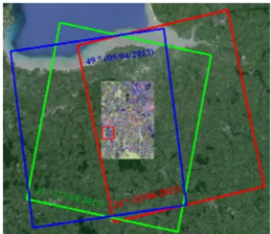
interest-ing plots in this study. The loamy soil is dominant in the soil composition. The selected bare fields are flat but some of them are with ridge due to the tillage operation. The anisotropic parcels with ridge are excluded, and merely the isotropic parcels are analyzed in this work. Multi-angular single look complex (SLC) fully po-larimetric RADARSAT-2 images are acquired in as-cending (24° image on 23/04/2013 and 49° image on 05/04/2013) and descending orbit (31°image on 23/04/2013) (in Fig.1) over test site. The raw data are extracted as coherence matrix T3, and a 7×7 boxcar filter is applied using PolSARpro4.2. The polarimetric images are Ortho-rectified and co-registered using NEST. The common region (shown in Fig.1 as Paul representation) of individual multi-angular images is extracted for further study. All the selected test fields are located in the common region. The incidence angle effect is demonstrated in Fig.2 that the single bounce decreases as incidence increases from 24°to 49°.
Figure 1. Multi-angular RADARSAT-2 swaths
(a) (b)
Figure 2. Pauli image: single bounce variation in term of incidence angle changed from (a) 24°to (b) 49°.
Ground truth measurements of surface roughness and soil moisture were carried out along with the SAR ac-quisitions over bare parcels (Some of the parcels are shown in Fig.2). Soil moisture from top 3.8cm is meas-ured using a calibrated Time Domain Reflectometry (TDR) 20 times for each parcel. The soil moisture ranges from 8% to 30% over test sites in April. Soil roughness is measured by a simpler and faster chain
approach proposed by Saleh [12], which is based on the principle that as a chain of given length is placed across a surface, the covered horizontal distance decreases as surface roughness increases. Therefore, the Saleh Roughness Factor (SRF) is defined as
2 SRF 100(1 ) 1 L L = − (1)
Where L1 is the length of given chain (146.5cm in this case), L2 is the chain covered horizontal distance. Thus, as surface roughness increases, L2 decreases, resulting in the increases of SRF. Considering the surface rough-ness is normally characterized as Random Roughrough-ness Factor (root mean square height of surface profile s) obtained using laser/pin roughness meter, a transforma-tion relatransforma-tionship in Eq.2 is derived based on simultane-ous measurements using both laser and chain approach. s(cm)=0.50715SRF0.7867 (2)
The SRF is measured 10 times for each parcel in two perpendicular directions. The in situ surface roughness and soil moisture over each parcel is assumed to be the average value of repeated measurements.
The meteorological data in Fig.3 were obtained from the nearest meteorological observing station, including the hourly temperate and hourly rainfall amount. The rain-fall amount on 05/04/2013 when 49°image was ac-quired and corresponding in situ data were collected was 8.2mm, which causes the soil moisture increase. In contrary, no rainfall is observed from 28/04/2013 to 23/04/2013, which is reasonable to assume the soil moisture and surface roughness are quasi-invariant dur-ing the acquisitions of 24°and 31°images and simul-taneous campaign (Two images acquired in quasi-invariant soil status are the requirement for multi-angular model ).
Figure 3. Meteorological records corresponding to the acquisition and campaign at station close to test sites.
3. POLARIMETRIC ANALYSIS
The sensitivity of linear polarization signature and po-larimetric parameter to soil moisture mv and surface roughness ks (k is the wave number) is analyzed in this section. The behaviours of RADARSAT-2 datasets are
compared with the simulation using IEM (selecting Gaussian correlation function and set autocorrelation length as kl=15), neglecting the scale difference be-tween real data and model.
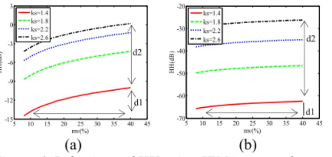
3.1. HH polarization signature
The sensitivity of HH linear polarization signature against soil moisture for different roughness status is simulated in Fig.4 using a low incidence angle 24°and a high incidence angle 49°. It is visible that as ks in-creases, the roughness contribution to the total backscat-tering coefficient decreases, particularly for small inci-dence angle data. The ratio of soil moisture effect (d1) and roughness effect (d2) is 0.37 at small incidence an-gle and 0.076 at large incidence anan-gles, which indicates that at higher incidence angle, the HH signature is pre-dominated by surface roughness.
5 10 15 20 25 30 35 40 45 -15 -12 -9 -6 -3 0 3 mv(%) HH (d B ) ks=1.4 ks=1.8 ks=2.2 ks=2.6 5 10 15 20 25 30 35 40 45 -70 -60 -50 -40 -30 -20 mv(%) HH (d B) ks=1.4 ks=1.8 ks=2.2 ks=2.6 (a) (b)
Figure 4. Behaviour of HH using IEM in term of mv and ks for incidence angle (a) 24°; (b) 49°.
The sensitivity of HH derived from RADARSAT-2 im-ages in respect of soil moisture and surface roughness is shown in Fig.5, indicating the real HH signature is sen-sitive to soil moisture at small incidence angle 24° significantly (In Fig.5a, * means statistical significance test result p< 0.05). At high incidence angle, no correla-tion between HH signature and soil moisture is found, but significant roughness effect is observed in Fig.5b, which is in accordance with the behaviour of IEM simu-lation even though the individual data scale is different.
5 10 15 20 25 30 35 40 -15 -12 -9 -6 -3 0 mv(%) HH (d B ) HH=0.12378x-10.6187 R=0.44466* ks<2 2<ks<=3 3<ks<=4 ks>4 5 10 15 20 25 30 35 40 -15 -12 -9 -6 -3 0 mv(%) HH (d B ) HH=-0.011327x-9.5125R=-0.061692 ks<2 2<ks<=3 3<ks<=4 ks>4 (a) (b)
Figure 5. Behaviour of HH using RADARSAT-2 data in term of mv and ks for incidence angle (a) 24°; (b) 49° .
3.2. Polarimetric descriptor
At high frequency and for natural environment where the reflection symmetry is satisfied, the SRα1 from first eigenvector is limited as Eq.3 in [13]
(3)
The sensitivity of SRα1 as a function of soil moisture and incidence angle is demonstrated in Fig.6, indicating
SRα1 decreases with soil moisture increases. And it is
obvious that at high incidence angle, SRα1 is more sen-sitive to soil moisture than at low incidence angle. 00 10 20 30 40 50 5 10 15 20 25 mv(%) SR α1( °) θ=24° θ=31° θ=49°
Figure 6. Behaviour of SRα1 using IEM in term of mv
and ks for three incidence angles.
5 10 15 20 25 30 35 40 0 5 10 15 20 mv(%) SR α1( °) SRα1=-0.068191x+5.6931 R=-0.19724 ks<2 2<ks<=3 3<ks<=4 ks>4 5 10 15 20 25 30 35 40 0 5 10 15 20 mv(%) SR α 1( °) SRα1=-0.079399x+8.0432 R=-0.31725 ks<2 2<ks<=3 3<ks<=4 ks>4 (a) (b)
Figure 7. Behaviour of SRα1 using RADARSAT-2 data
in term of mv for incidence angle (a) 24°; (b) 49° .
The SRα1 in Fig.7 decreases with soil moisture for both low and high incidence angle data, but the sensitivity to soil moisture is obviously improved at high incidence angle, which is in agreement with the IEM simulation. Since the RADARSAT-2 datasets presented in Fig.2 as Pauli RGB show that the single bounce decreases when incidence angle becomes large, thus the behaviour of
SRα1 at high incidence angle provides an alternative
potential for soil moisture characterization by just using high incidence angle polarimetric data.
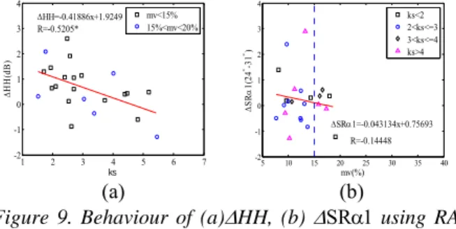
3.3. Two angular difference Δ descriptor
The behaviour of ΔHH is quasi independent on soil moisture as shown in Fig.8, verifying the possibility to use two incidence angle observing difference to separate the surface roughness contribution in order to estimate soil moisture accurately. The ΔHH derived from two RADARSAT-2 images is shown in Fig.9a, demonstrat-ing that ΔHH is significantly relative to surface
rough-1 * 2 2 2 2 2 * 2 * 2 2 2 2 2 * 2 arctan 2 (| | | | (| | | | ) 4| | ) 2 (| | | | (| | | | ) 4| | )
Where 2 /cos 2 /cos
and Γis the Fresnel coefficient
hh vv vv hh vv hh hh vv hh vv vv hh vv hh hh vv hh hh vv vv SR f f f f f f f f f f f f f f f f f and f α θ θ = ⎛ − − + − + ⎞ ⎜ ⎟ ⎜ − − + − + ⎟ ⎝ ⎠ =− Γ = Γ Δ Δ d1 d2 d1 d2
ness regardless the soil moisture. It should be noted that in Fig.9b, it is also statistically fitted that ΔSRα1 is in-versely relative with soil moisture, even though the cor-relation is quite weak (R=-0.1448), in accordance with the variation trend of simulated Δ SRα1 shown in Fig.6.
35 10 15 20 25 30 35 40 45 6 9 12 15 mv(%) Δ HH( dB ) ks=1.4 ks=1.8 ks=2.2 ks=2.6
Figure 8. Behaviour of ΔHH using IEM in term of mv
and ks for incidence angles 24°vs 31°.
1 2 3 4 5 6 7 -2 -1 0 1 2 3 4 ks ΔHH (d B) ΔHH=-0.41886x+1.9249 R=-0.5205* mv<15% 15%<mv<20% 5 10 15 20 25 30 35 40 -2 -1 0 1 2 3 4 mv(%) ΔSR α 1( 24 °-3 1 °) ΔSRα1=-0.043134x+0.75693 R=-0.14448 ks<2 2<ks<=3 3<ks<=4 ks>4 (a) (b)
Figure 9. Behaviour of (a)ΔHH, (b) ΔSRα1 using
RA-DARSAT-2 data in term of ks and mv two incidence an-gle 24°vs 49° .
4. CONCLUSION
With the aim to study the potential use of C-band multi-angular polarimetric datasets for bare agricultural char-acterization and further parameter retrieval, the linear signature HH and a polarimetric parameter SRα1 are extracted from RADARSAT-2 datasets and compared with the behaviours of IEM simulation. The study veri-fies that HH at low incidence angle is more relative to soil moisture while HH at high incidence angle is more dependent on surface roughness. The polarimetric pa-rameter SRα1 is noticed to decreases with soil moisture and the sensitivity is improved at high incidence angle. Multi-angular descriptor Δ HH is found to decrease with surface roughness while no relation is observed with soil moisture, in accordance with IEM simulation and the results obtained by [7]. In addition, ΔSRα1 is weakly relative with soil moisture but the variation trend is in agreement with simulation. The dynamic scale of polarimetric descriptors derived from RADAR-SAT-2 dataset is less than the corresponding descriptors simulated from IEM model, even though the variation trends in term of soil moisture and surface roughness are in accordance. Thus, the IEM model is required to be adapted for modelling the RADARSAT-2 data be-haviours with the same scale.
5. REFERENCES
[1]Y.Oh, “Quantitative retrieval of soil moisture content and surface roughness from multipolarized radar obser-vations of bare soil surfaces,” IEEE
Trans.Geosci.Remote Sensing, vol. 42, pp. 596–601,
2004.
[2]N.Baghdadi, R.Cresson, E.Pottier, M.Aubert, M.Zribi, A.Jacome, and S.Benabdallah, “A potential use for the C-band polarimetric SAR parameters to charac-terize the soil surface over bare agriculture fields,”
IEEE Trans.Geosci.Remote Sensing, vol. 50, pp. 3844–
3858, 2012.
[3]A. K. Fung, Microwave Scattering and Emission
Models and Their Applications, Boston, Ed. ARTECH
House, 1994.
[4]J.S.Lee and E. Pottier, Polarimetric radar imaging
from basics to applications, T. . F. Group, Ed. CRC
Press, 2009.
[5]M.R.Sahebi, J.Angles, and F.Bonn, “A comparison of multi-polarisation and multi-angular approach for estimating bare soil surface roughness from spaceborne radar data,” Can. J. Remote Sensing, vol. 28, pp. 641– 652, 2002.
[6]H.S.Srivastava, P.Patel, Y.Sharma, and R. Navalgund, “Large-area soil moisture estimation using multi-incidence-angle RADARSAT-1 SAR data,”
IEEE Geoscience and Remote Sensing Letters, vol. 47,
pp. 2528–2535, 2009.
[7]M.Zribi and M.Dechambre, “A new empirical model to retrieve soil moisture and roughness from c-band radar data,” Remote Sensing of Environment, vol. 84, pp. 42–52, 2002.
[8]M. Rahman, M. Moran, D. Thoma, R. Bryant, C. H. Collins, T. Jackson, B. Orr, and M. Tischler, “Mapping surface roughness and soil moisture using multi-angle radar imagery without ancillary data,” Remote Sensing
of Environment, vol. 112, no. 2, pp. 391 – 402, 2008.
[9]N.Baghdadi, C.King, A.Bourguignon, and A.Remond, “Potential of ERS and Radartsat data for surface roughness monitoring over bare agricultural fields: application to catchments in northern France,”
International journal of remote sensing, vol. 23, pp.
3427–3443, 2002.
[10]I.Hajnsek, E.Pottier, and S. Cloude, “Inversion of surface parameters from polarimetric sar,” IEEE
Trans.Geosci.Remote Sensing, vol. 41, pp. 727–744,
2003.
[11]S. Allain, L. Ferro-Famil, and E. Pottier, “Two
novel surface model based inversion algorithms using multi-frequency polsar data,” in IGARSS, 2004.
[12]A.Saleh, “Soil roughness measurements:chain method,” J.Soil and Water Cons, vol. 48, pp. 527–529, 1993.
[13]S.Allain, “Caracterisation d’un sol nu a partire de donnes SAR polarimetriques etude multi-frequency et multi-resolutions,” Ph.D. dissertation, Universite de Rennes 1, 2003.