HAL Id: hal-00795327
https://hal-mines-paristech.archives-ouvertes.fr/hal-00795327
Submitted on 27 Feb 2013
HAL is a multi-disciplinary open access
archive for the deposit and dissemination of
sci-entific research documents, whether they are
pub-lished or not. The documents may come from
teaching and research institutions in France or
abroad, or from public or private research centers.
L’archive ouverte pluridisciplinaire HAL, est
destinée au dépôt et à la diffusion de documents
scientifiques de niveau recherche, publiés ou non,
émanant des établissements d’enseignement et de
recherche français ou étrangers, des laboratoires
publics ou privés.
Assessment of Heliosat-4 surface solar irradiance derived
on the basis of SEVIRI-APOLLO cloud products
Zhipeng Qu, Armel Oumbe, Philippe Blanc, Mireille Lefèvre, Lucien Wald,
Marion Schroedter Homscheidt, Gerhard Gesell, Lars Klueser
To cite this version:
Zhipeng Qu, Armel Oumbe, Philippe Blanc, Mireille Lefèvre, Lucien Wald, et al.. Assessment of
Heliosat-4 surface solar irradiance derived on the basis of SEVIRI-APOLLO cloud products. 2012
EUMETSAT Meteorological Satellite Conference, Sep 2012, Sopot, Poland. pp.s2-06. �hal-00795327�
Assessment of Heliosat-4 surface solar irradiance derived on the
basis of SEVIRI-APOLLO cloud products
Zhipeng Qu, Armel Oumbe, Philippe Blanc, Mireille Lefèvre, Lucien Wald
MINES ParisTech, Centre for Energy and Processes, BP 207 – 06904, Sophia Antipolis, France
Marion Schroedter-Homscheidt, Gerhard Gesell, Lars Klueser
German Remote Sensing Data Center, German Aerospace Center (DLR), Postfach 1116, D-82234
Wessling, Germany
Abstract
The Heliosat-4 method developed by the MINES ParisTech and the German Aerospace Center (DLR), aims at estimating surface downwelling solar irradiance (SSI). It benefits from advanced products derived from recent Earth Observation missions, among which the cloud products are crucial for the assessment of SSI. The APOLLO cloud product provided by DLR includes abundant information about the cloud physical and optical properties. The performances of Heliosat-4 when using APOLLO product are evaluated for the period of 2004-2009. The estimated SSIs are compared to measurements made at six stations within the Baseline Surface Radiation Network. Extensive analysis of the discrepancies offers an in-depth view of the performance of Heliosat-4/APOLLO, an understanding of the advantages of this combination Heliosat-4/APOLLO when compared to existing methods and the identification of restrictions in both Heliosat-4 and the APOLLO product for future improvements.
1. INTRODUCTION
A new direct method, Heliosat-4, is currently developed by the MINES ParisTech and the German Aerospace Center (DLR), aiming at estimating surface downwelling solar irradiance (SSI). This method is composed by two parts: a clear-sky module and a cloud-ground module (Oumbe et al. 2009). The clear-sky module is based on the radiative transfer model (RTM) libRadtran and benefits from advanced products derived from recent Earth Observation missions. The cloud-ground module uses two-stream and delta-Eddington approximations and is fed by cloud products as well as the information about the ground albedo. Among all the input products, the cloud products are crucial for the assessment of SSI.
AVHRR Processing scheme Over cLouds, Land and Ocean (APOLLO) is a suite of algorithms originally developed for the AVHRR instrument (Kriebel et al. 1989, 2003). DLR has adapted it to the images of the SEVIRI instrument aboard Meteosat Second Generation satellite (MSG). The APOLLO product provided by DLR includes abundant information about the cloud physical and optical properties, such as cloud optical depth, cloud type, cloud classification, cloud phase and cloud coverage etc. Given its high spatial and temporal resolutions, the APOLLO product is suitable for use in solar energy applications.
In this study, we evaluate the performances of Heliosat-4 when using APOLLO product. The estimated SSIs are compared to measurements made at six stations within the Baseline Surface Radiation Network for the period 2004-2009.
2. HELIOSAT-4
The Heliosat-4 method is being developed jointly by MINES ParisTech and DLR within MACC/MACC-II project (Monitoring atmospheric composition & climate, FP7). The objective is to supply information about global, diffuse and direct surface irradiance as well as their spectral distribution for the uses in various domains: solar energy, biomass, agriculture, human health, weather or climate.
The concept of Heliosat-4 is based on the separation of the calculation of the SSI in two parts (Eq. 1): irradiance of clear-sky with zero ground albedo, , and the effects of the cloud and surface . Similarly, the operational implementation of Heliosat-4 is composed by two parts: a clear
sky module based on the radiative transfer model libRadtran, and a cloud-ground module using two-stream and delta-Eddington approximations.
(1)
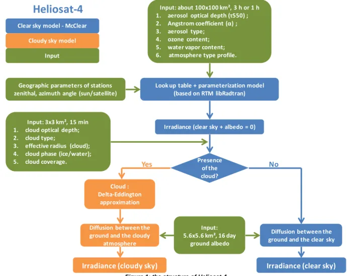
Figure 1 shows the structure of Heliosat-4. The first stage in Heliosat-4 is to calculate the irradiance of clear-sky with zero albedo. In this stage, we integrate the inputs like aerosols properties (optical depth at 550 nm, Angstrom coefficient, and type), total ozone column, total water vapor column, atmospheric profile as well as geographic parameters of the ground, satellite and sun. Then the second step is to check the cloud information in order to define if the pixel is cloud-free. If the cloud mask indicates that there is no presence of the cloud, the diffusion effect between the ground and the clear-sky will be simulated by taking into account the ground albedo. Otherwise, the cloudy sky module will be activated. In this case, the two-stream and delta-Eddington approximations are used to obtain the SSIs under cloudy sky. The inputs of this module are the ground albedo and cloud properties (optical depth, cloud phase, water content and effective radius of cloud particles). One should note that Heliosat-4 calls upon the McClear clear-sky model (in blue blicks) (Lefèvre et al., 2012) developed within the MACC project. Its look-up tables are calculated by the means of libRadtran.
The Heliosat-4 method will operationally run within the MACC-II project from late 2013. The output of Heliosat-4 will be the global, direct and diffuse horizontal downwelling surface irradiance integrated over the total spectrum for every 15 min with spatial resolution of 3 km at nadir. The covered zone will be the field-of-view of the SEVIRI instrument.
Look up table + parameterization model (based on RTM libRadtran) Input: about 100x100 km², 3 h or 1 h 1. aerosol optical depth (τ550) ; 2. Angstrom coefficient (α) ; 3. aerosol type;
4. ozone content; 5. water vapor content; 6. atmosphere type profile.
Irradiance (clear sky + albedo = 0)
Presence of the cloud? Input: 3x3 km², 15 min
1. cloud optical depth; 2. cloud type;
3. effective radius (cloud); 4. cloud phase (ice/water);
5. cloud coverage. Yes No
Cloud : Delta-Eddington
approximation
Diffusion between the ground and the clear sky Input:
5.6x5.6 km², 16 day ground albedo
Irradiance (clear sky) Geographic parameters of stations
zenithal, azimuth angle (sun/satellite)
Diffusion between the ground and the cloudy
atmosphere
Irradiance (cloudy sky) Clear sky model - McClear
Cloudy sky model Input
Heliosat-4
3. APOLLO CLOUD PRODUCT
Table 1 shows the available parameters and the characteristics of APOLLO product.
Parameters SEVIRI-APOLLO
Cloud optical depth Range: 0-500 (minimal value, except 0, is 0.45) Cloud layer Single layer
Cloud type 4 types: low, medium, high and thin cloud Cloud classification
Only for fully covered pixels: vertical extended, thin cloud, water cloud, multi-layer cloud, horizontally homogeneous cloud and the different
compositions of these five classes
Cloud phase Water cloud: low, medium and high cloud; Ice cloud: thin cloud. Cloud top temperature Only for full covered pixels
Cloud coverage in % All cloudy pixel
Cloud mask Cloudy and clear over land, ocean or snow/ice. Resolution SEVIRI pixels (3 km nadir), 15 min, day and night
Table 1: available parameters and characteristics of APOLLO product
In this study, we use the cloud type to define the cloud phase. Among the four types of cloud in APOLLO: low, medium, high and thin cloud, the first three types are considered as water cloud and the last type, thin cloud, is considered as ice cloud. The thickest clouds are often high vertical cloud like cumulonimbus and are covered by an ice top. However, the lower part of these clouds is often composed by water drops, and we consider that this lower part is the main factor for the attenuation of the solar irradiance. The thin cloud is often cirrus and will be considered as thin ice cloud.
The cloud effective radius and water content are set as default values according to two cloud phases: effective radius of 20 µm, water content of 0.005 g/m3 for ice cloud, 10 µm and 1.0 g/m3 for water cloud.
4. VALIDATION
Table 2 shows the input sources of Heliosat-4 in this study. APOLLO product is used as cloud input. Aerosols properties, ozone and water vapour are taken from MACC reanalysis. MODIS BRDF/Albedo Snow-free Quality product (MCD43C2) is used as the ground albedo product. The daily mean values of ozone, water vapour quantities and aerosol properties are used in the clear-sky model McClear.
Table 2: the input to Heliosat-4
We validated Heliosat-4 for 6 stations (table 3) within the Baseline Surface Radiation Network (BSRN) which provides high quality ground measurements of surface solar irradiance (global horizontal, diffuse horizontal and direct normal irradiances) for the period of 2004-20090. Quality check is performed on the measurements to ensure that we compare Heliosat-4 results with reliable pyranometric measurements.
Station Country Latitude Longitude Altitude (m) Carpentras France 44.0830°N 5.0590°E 100
Payerne Switzerland 46.8150°N 6.9440°E 491 Sede Boqer Israel 30.9050°N 34.7820°E 500 Tamanrasset Algeria 22.7800°N 5.5100°E 1385
Camborne United Kingdom 50.2167°N 5.3170°W 88 Toravere Estonia 58.2540°N 26.4620°E 70
Table 3: Validated BSRN stations
Variable Data sources Temporal resolution Spatial resolution Aerosols properties and types MACC (EU FP7) 3 h 1.125°
Cloud properties and types APOLLO (DLR) 15 min 3 km nadir Total ozone column MACC (EU FP7) 3 h 1.125° Total water vapour column MACC (EU FP7) 3 h 1.125° Ground albedo MODIS (NASA) 16 d 5.6 km
BSRN stations measure surface irradiance every one minute. The data have been summarized to 15 min before comparison to Heliosat-4 outputs.
5. CIRCUMSOLAR IRRADIANCE (CSI) CORRECTION
Pyrheliometers used in the BSRN network have an angular aperture of 5°. A part of the diffuse radiation, named circumsolar irradiance (CSI), is included in the measured direct normal irradiance. Therefore, the direct irradiance calculated by Heliosat-4 is not exactly what is measured by BSRN. In this study, an empirical correction was performed (Shiobara and Asano, 1994, Reinhard et al., 2012) on Heliosat-4 to produce a quantity similar to the measured direct irradiance. To that extent, the optical depth is reduced by 60% for thin ice cloud, 25% for thin water cloud and 5% for aerosols, when computing direct irradiance in Heliosat-4.
Table 4 shows the impact of this correction for the calculated direct horizontal irradiance. We compared ground measurements and estimates made by Heliosat-4 with and without the correction. Cloud inputs are from APOLLO. The relative bias and root mean square errors (RMSE) are calculated by using their absolute values in unit of W/m² divided by the means of measurements. One can observe that for most of the cases, the empirical CSI correction improves the performance of the Heliosat-4. Therefore, all the results presented later include the CSI correction.
Station Mean (W/m²) Bias (W/m²) no/with corr. Bias (%) no/with corr. RMSE (W/m²) no/with corr. RMSE (%) no/with corr. Carpentras 242 -10/-3 -4/-1 81/79 34/33 Payerne 184 -8/1 -4/0 108/105 59/57 Sede Boqer 366 -49/-43 -14/-12 132/129 36/35 Tamanrasset 363 4/12 1/3 125/123 34/34 Camborne 113 -3/2 -3/2 90/88 80/78 Toravere 119 -31/-24 -26/-20 109/104 91/87
Table 4: comparison of performance of Heliosat-4 before and after the CSI correction
6. RESULTS
Table 5 shows the performance of Heliosat-4 with APOLLO product for the estimation of global irradiance on horizontal surface (GHI). All the valid data from February 2004 to December 2009 are used except for the station Camborne (February 2004 - December 2007) due to the lack of BSRN data for the year 2008 and 2009. The biases are small for Sede Boqer, Tamanrasset, Capentras and Toravere (less than 5%) and close to 25 W/m² for Payerne and Camborne. The RMSE is similar for all stations and close to 80-90 W/m². Sede Boqer and Tamanrasset show the best performances in relative RMSE, while Toravere has the worst performances with relative RMSE of 41%.
Station Mean (W/m²) Bias (W/m²) Bias (%) RMSE (W/m²) RMSE (%)
Carpentras 363 15 4 73 20 Payerne 296 26 9 95 32 Sede Boqer 493 -2 -0 76 15 Tamanrasset 537 1 0 93 17 Camborne 257 28 11 90 35 Toravere 229 12 5 95 41
Table 5: performance of Heliosat-4 with APOLLO for global irradiance (6 years), 15 min data
Table 6 shows the same scores but for direct horizontal irradiance (DHI). The bias is small as a whole except for the stations Sede Boqer and Toravere. The RMSE ranges between 80 W/m² and 130 W/m² and is much greater than that observed for the global irradiance.
Station Mean (W/m²) Bias (W/m²) Bias (%) RMSE (W/m²) RMSE (%) Carpentras 242 -3 -1 79 33 Payerne 184 1 0 105 57 Sede Boqer 366 -43 -12 129 35 Tamanrasset 363 12 3 123 34 Camborne 113 2 2 88 78 Toravere 119 -24 -20 104 87
Table 6: performance of Heliosat-4 with APOLLO for direct horizontal irradiance (6 years), 15 min data
Table 7 shows the performance for all stations and years merged. The relative bias is 3% for global irradiance and -4% for direct irradiance. The relative RMSE is 24% for global and 45% for direct irradiance.
Type Mean (W/m²) Bias (W/m²) Bias (%) RMSE (W/m²) RMSE (%)
Global 370 12 3 87 24
Direct 241 -10 -4 108 45
Table 7: global performance of Heliosat-4 with APOLLO for all stations and all years, 15 min data
In the literature, there are few published validation results presented with summarization of 15 min. However, Beyer et al. (2009) published performances of different methods for summarization of 1 h. The performance in RMSE is expected to be better for 1 h than for 15 min since the strong variations are averaged; the bias should remain the same approximately. Table 8 reproduces the performances found in Beyer et al. (2009). The work was done for the GHI and the direct irradiance received on a plane normal to the sun rays (DNI). As we do not have computed the performances for DNI but only for direct on horizontal surface, we report here only the GHI. The methods selected by Beyer et al. (2009) with validated years are: Satel-Light (year 2000), Meteonorm-6 (2000), Heliosat-2 (2005), Solemi (2005), EnMetSol (2000), Meteonorm-6 (2005), Heliosat-3 (2005), EnMetSol (2005).
By comparing Tables 5, 6 and 8, we can conclude that the bias observed for Heliosat-4 with APOLLO product (15 min data) is similar to that of the existing methods presented in the literatures (1 h data). The relative RMSE for Heliosat-4 / APOLLO is similar to that reported by Beyer et al. (2009) or slightly greater. Taking into account that we are dealing with summarization of 15 min less than 1 h and that the RMSE decreases when the summarization increases, we are confident that the RMSE for Heliosat-4 for summarization of 1 h should be similar or less than those of the existing methods.
Station Relative bias (%) Relative RMSE (%) Carpentras -1~5 15~20 Payerne -5~3 20~30 Sede Boqer -11~7 17~20 Tamanrasset 3~5 17~19 Camborne 2~11 25~30 Toravere -4~6 20~30
Table 8: the approximate performances of different methods for the estimation of hourly mean of SSI. After Beyer et al. (2009)
7. CONCLUSION
Heliosat-4 exhibits state-of-the-art performances. These performances depend on the station and show little variations with year for a given station.
Large RMSEs observed for the two desert stations, Sede Boqer and Tamanrasset, are believed to be mainly due to incorrect estimation in aerosol properties. Good results are found for the station Carpentras. Heliosat-4 has a lower performance for the stations Payerne, Camborne, Toravere. We assume that it is probably due to the frequent presence of scattered clouds, which may flow unnoticed by APOLLO over the pyranometer if their size is much smaller than the pixel size, or on the contrary may appear as a dense cloud deck while they may actually contain holes which will result in large instantaneous irradiances at pyranometer level.
A part of the diffuse radiation, named circumsolar, is included in the measured direct normal irradiance. Therefore, the direct irradiance calculated by Heliosat-4 is not exactly what measured by
BSRN. A simple empirical correction with fixed correction factors for ice/water and aerosols was performed to calculate the direct horizontal irradiance. This correction improves the performance of Heliosat-4.
The performance of Heliosat-4 is equivalent to the existing cloud index methods (e.g. Heliosat-2 method), and with a strong potential of improvement, in particular, in its ability to decompose the surface solar irradiance into the direct and diffuse components.
8. ACKNOWLEDGMENTS
The research leading to these results has received funding from the European Union’s Seventh Framework Programme (FP7/2007-2013) under Grant Agreement no. 218793 (MACC project) and no. 283576 (MACC-II project).
9. REFERENCES
Beyer, H. G., Martinez, J. P., Suri, M., Torres, J. L., Lorenz, E., Müller, S. C., Hoyer-Klick, C., Ineichen P.: Report on Benchmarking of Radiation Products – MESoR project, 2009.
Kriebel, K. T., Gesell, G., Kästner, M., and Mannstein, H.: The cloud analysis tool APOLLO: Improvements and validations, International Journal of Remote Sensing, 24:12, 2389-2408, 2003 Kriebel, K. T., Saunders R. W., and Gesell, G.: Optical properties of clouds derived from fully cloudy AVHRR pixels. Beitr. Phys. Atmosph., 62, 3, pp 165-171, 1989.
Lefèvre, M., Oumbe, A., Blanc, P., Gschwind, B., Qu, Z., Wald L., Schroedter-Homscheidt, M., Hoyer-Klick, C., Arola, A., Morcrette. J.-J.: Using MACC-derived products to predict clear-sky irradiance at surface. In Geophysical Research Abstracts, vol 14, 2012. EGU General Assembly 2012, 22-27 April 2012.
Oumbe, A., Blanc, P., Ranchin, T., Schroedter-Homscheidt, M., and Wald, L.: A new method for estimating solar energy resource. In Proceedings of the ISRSE 33, held in Stresa, Italy, 4-9 May 2009. Published by Joint Research Center, Ispra, Italy, USBKey, paper 773, 2009.
Reinhardt, B., Buras, R., Bugliaro, L., Mayer, B., Wilbert, S.: Circumsolar Radiation- a Reason for Solar Resource Overestimation – Globally Characterized. 12th EMS Annual Meeting & 9th European Conference on Applied Climatology (ECAC), 2012.
Shiobara, M. and Asano, S.: Estimation of Cirrus Optical Thickness from Sun Photometer Measurements. Journal of Applied Meteorology, Volume 33, pp. 672-681, 1994.