Numerical simulations of coupled groundwater
flow and heat transport incorporating freeze/thaw
cycles and phase change in a continuous permafrost
environment
Thèse
Masoumeh Shojae Ghias
Doctorat interuniversitaire en Sciences de la Terre
Philosophiæ Doctor (Ph.D.)
Québec, Canada
i
Résumé
Dans les régions nordiques, l’une des conséquences du réchauffement climatique est le dégel du pergélisol. En plus de favoriser la libération de quantités importantes de méthane et de dioxyde de carbone dans l’atmosphère, le dégel du pergélisol entraînera une modification des conditions hydrologiques locales et régionales, affectant ainsi les écosystèmes. Ce dégel pourra aussi conduire à un affaissement des sols et endommager ainsi les infrastructures routières.
Dans le cadre de cette étude, des simulations numériques couplant l’écoulement des eaux souterraines et le transport de chaleur ont été réalisées dans le but de mieux appréhender les interactions entre l’écoulement des eaux souterraines et la dynamique thermique relative au dégel du pergélisol sur les pistes de l’Aéroport d’Iqaluit, Nunavut, Canada. Un modèle conceptuel du site est d’abord développé et le modèle numérique bidimensionnel correspondant est calé à partir des températures observées du sol. Les impacts futurs du réchauffement climatique sur le régime thermique et le système d’écoulement, aussi que le tassement dû au dégel, sont ensuite simulés sur la base des scénarios climatiques proposés par le Groupe Intergouvernemental sur l’Évolution du Climat (GIEC).
Dans le cadre d’un réchauffement climatique, la couverture neigeuse de surface est identifiée comme le facteur principal affectant la dégradation du pergélisol, y compris par son rôle dans l’accroissement de la sensibilité de la dégradation du pergélisol aux changements de divers facteurs hydrogéologiques. Dans ce cas, le transfert de chaleur par advection joue un rôle relativement mineur, quoique non négligeable, vis-à-vis du transfert de chaleur par conduction, du fait de l’extension importante d’un sol de faible perméabilité à proximité de la surface. Le transfert de chaleur par convection, qui est fortement influencé par la couche de neige superficielle, contrôle la libération de l’eau non gelée et la profondeur de la couche active aussi bien que l’amplitude du tassement et du soulèvement par le dégel.
ii
L'effet de la zone non saturée sur le dégel du pergélisol est plus important dans les sols fins, recouverts de neige en surface. De plus, l’ampleur du tassement dû au dégel augmente considérablement en présence d’une couverture neigeuse. Enfin, les simulations ont montré que, le long de routes, les zones les plus vulnérables au tassement sont les accotements recouverts de neige ainsi que les zones de transition adjacentes au bloc de pergélisol.
Les simulations numériques ont également montré l’importance d’utiliser les fonctions de gel appropriées pour les types de sols impliqués. En effet, la position du front de gel (couche active) varie en fonction des caractéristiques du sol.
Les résultats des simulations ont également mis en évidence les effets d'une distribution stochastique de la conductivité hydraulique sur l’advection thermique. Les taux de dégel du pergélisol sont relativement plus élevés dans des zones de haute perméabilité, trouvées dans la structure du sol d'un système hétérogène, que dans le cas d’un sol homogène. Paradoxalement, les résultats ont montré que dans les zones de décharge, le transport de chaleur par advection a pour conséquence d'augmenter le plafond du pergélisol. En effet, l'eau froide s'écoulant dans ce secteur annule le gain de chaleur résultant du processus de conduction.
iii
Abstract
At high northern latitudes, climate warming will induce permafrost degradation that will modify local and regional hydrogeological systems and ecosystem functionality, as well as increase the release of carbon and methane to the environment. Northern infrastructure, in particular roads and embankments, will also experience significant degradation. In this study, numerical simulations of coupled groundwater flow and heat transport have been developed to assess the effects of realistic combinations of hydrogeological parameters and surface conditions on the temporal and spatial evolution of permafrost degradation in a cold-region paved terrain, at the Iqaluit airport, Nunavut. A conceptual model is first developed for the site and a corresponding 2D numerical model is calibrated to the observed groundwater flow and thermal regime. Future climate warming impacts on the thermal regime and flow system, as well as thaw settlements are then simulated based on climate scenarios proposed by the IPCC (Intergovernmental Panel on Climate Change). Under climate warming, the surface snow cover is identified as the leading factor affecting permafrost degradation, and significantly contributes to positive feedback between the hydrogeological flow system and the frozen ground. In this case, advective heat transport plays a relatively minor, but non-negligible role compared to conductive heat transport, due to the significant extent of low-permeability soil close to surface. Conductive heat transport, which is strongly affected by the surface snow layer, controls the release of unfrozen water and the depth of the active layer as well as the magnitude of thaw settlement and frost heave.
The effect of the unsaturated zone on permafrost thaw was most important in finer soil where overlain by snow. The magnitude of thaw settlement also significantly increases with a snow cover. The most vulnerable areas to permafrost thaw settlement along a road or taxiway embankment would be the snow-covered shoulders, as well as the transition zones at the adjacent margins of the permafrost block.
iv
The simulation results also showed the importance of selecting the appropriate freezing function based on the type of soil, when frequent freezing and thawing cycles occur in a permafrost setting. The thaw front simulated with a smooth (low slope) freezing function, was deeper compared to that for a steeper freezing function.
The simulation results also highlighted the contributing effects of a stochastic hydraulic conductivity distribution on thermal advection. Permafrost thaw rates in high permeability zones, found in the soil structure of a heterogeneous system, are larger than rates for a homogeneous soil. Advective heat transport can paradoxically also increase the permafrost table in downgradient areas where the flowing cold water negates heat gain from conduction alone.
v
Contents
Résumé ... i
Abstract ... iii
Contents ... v
List of Figures ... viii
List of Tables ... x
Acknowledgment ... xi
Chapter 1 ... 1
1 Introduction ... 1
1.1 Background ... 1
1.2 Review of current literature ... 4
1.2.1 Analytical solutions developed for heat transport ... 4
1.2.2 Numerical models of coupled groundwater flow and heat transport ... 5
1.2.3 Field studies and laboratory tests ... 11
1.2.4 Current research needs ... 12
1.3 Research objective and methodology ... 14
Chapter 2 ... 17
2 Study Site ... 17
2.1 Location ... 17
2.2 Current issues related to thawing of permafrost ... 19
2.3 Field investigations and observed data ... 19
2.4 Climate data ... 22
2.5 Geology and hydrogeology ... 23
2.6 Conceptual hydrogeological-thermal model for the Iqaluit site ... 32
Chapter 3 ... 35
vi
3.1 Governing equations... 35
3.2 Verification ... 38
Chapter 4 ... 47
4 Climate change scenarios ... 47
Chapter 5 ... 55
5 Numerical simulations of coupled groundwater flow and heat transport incorporating freeze/thaw cycles and phase change in a continuous permafrost environment ... 55
5.1 Introduction ... 58
5.2 Study area and conceptual Model ... 59
5.2.1 Boundary and initial conditions ... 60
5.2.2 Observed climate data and warming scenarios ... 63
5.3 Numerical model ... 64
5.4 Results ... 65
5.4.1 Model Calibration ... 65
5.4.2 The role of groundwater flow ... 66
5.5 Discussion and conclusions ... 72
Chapter 6 ... 75
6 Controls on permafrost thaw in a coupled groundwater-flow and heat-transport system: Iqaluit Airport, Nunavut, Canada ... 75
6.1 Introduction ... 77
6.2 Site description and conceptual model ... 79
6.2.1 Climate data ... 83
6.3 Numerical model ... 85
6.3.1 Governing equations ... 85
6.3.2 Model discretization and boundary conditions ... 88
6.3.3 Calibration and sensitivity analysis ... 91
6.4 Simulation results ... 96
6.4.1 The role of groundwater flow ... 96
6.4.2 Consideration of the unsaturated zone ... 101
6.4.3 Effect of snow cover ... 107
vii
6.5 Discussion ... 112
6.6 Conclusions ... 114
Chapter 7 ... 116
7 Numerical simulations of shallow groundwater flow and heat transport in a continuous permafrost setting under the impact of climate warming ... 116
7.1 Introduction ... 118
7.2 Methods ... 120
7.3 Results ... 130
7.3.1 Effect of the freezing function (Wu(T))... 130
7.3.2 Effects of heterogeneity ... 140
7.4 Discussion ... 147
7.5 Conclusion ... 149
Chapter 8 ... 151
8 Conclusions and perspectives ... 151
Bibliography ... 156
viii
List of Figures
Figure 2.1. Geological location of the Iqaluit Airport and the 2-D cross-section. ... 18
Figure 2.2. Location of the boreholes drilled at the Iqaluit airport. ... 21
Figure 2.3. The mean annual air temperature and annual precipitation variations, observed for the study site. ... 22
Figure 2.4. Surficial geology map of the study site, Iqaluit airport. ... 24
Figure 2.5. Schematic stratigraphy of the deposits extracted from drilling. ... 25
Figure 2.6. Geological cross section constructed along the center of Taxiway Alpha... 28
Figure 2.7. Changes in hydrographic network of Iqaluit airport from its origin ... 30
Figure 2.8. The two-dimensional vertical-section conceptual model ... 33
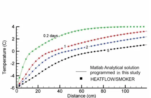
Figure 3.1. Design of the simulation for comparing HEATFLOW-SMOKER with the Lunardini ... 40
Figure 3.2. Comparison of the Lunardini versus HEATFLOW-SMOKER. ... 41
Figure 3.3. Design of the simulation for verifying HEATFLOW/SMOKER model for thaw settlement ... 44
Figure 3.4. Simulated thaw settlement by the HEATFLOW/SMOKER model for the designed 2-D domain ... 45
Figure 4.1. Air temperatures and precipitation variations for the observed climate, and for the projected future climate ... 53
Figure 5.1. Location of the Iqaluit Airport, and the location of the 2-D cross-section ... 61
Figure 5.2. Outline of the two-dimensional vertical conceptual model. ... 62
Figure 5.3. One-dimensional simulated and observed ground temperature profiles ... 66
Figure 5.4. Conduction and advection-driven permafrost thaw ... 70
Figure 5.5. Evolution of the groundwater flow system under advection-conduction ... 71
Figure 5.6. Effective hydraulic conductivity variations during the warming scenarios ... 72
Figure 6.1. Geographical location of the Iqaluit Airport, Nunavut Territory. ... 81
Figure 6.2. The two-dimensional vertical-section conceptual model ... 82
Figure 6.3. Annual, maximum and minimum mean monthly air temperatures generated for the 2013-2100. ... 84
Figure 6.4. Seasonal variations of the heat transfer coefficient γ and the additional temperature-independent heat flux (Bzf) ... 93
Figure 6.5. Simulated and observed vertical temperature profiles ... 94
ix
Figure 6.7. Role of groundwater flow: Conduction and advection-driven simulated
permafrost thaw under the climate warming ... 100
Figure 6.8. Role of groundwater flow: Spatial and temporal variations of the active layer depth ... 101
Figure 6.9. Consideration of the unsaturated zone: Simulated temperatures for the unsaturated and fully saturated Case ... 103
Figure 6.10. Effect of the unsaturated zone:Vertical profiles of simulated temperature and unfrozen water saturation ... 106
Figure 6.11. Effect of snow cover: Simulated profiles of the seasonal thaw front ... 108
Figure 6.12. Effect of snow cover: Vertical profiles of simulated monthly mean temperatures, comparing the snow-cover and snow-free simulations. ... 109
Figure 6.13. Thaw settlement and frost heave ... 111
Figure 7.1. Site location maps ... 124
Figure 7.2. Hydrogeological conceptual model ... 125
Figure 7.3. Annual, maximum and minimum mean monthly air temperature ... 129
Figure 7.4. Unfrozen water saturation as a function of temperature using a steep freezing function and a smooth freezing function ... 130
Figure 7.5. Simulated temperature for steep and smooth freezing function... 133
Figure 7.6. Thermal behaviour resulting from advective-conductive heat transport in the homogeneous system ... 135
Figure 7.7. Simulated thaw front using different freezing functions... 137
Figure 7.8. Temperature changes over time at monitoring points using a steep freezing function and smooth freezing function ... 139
Figure 7.9. Initial stochastic K field, porosity distribution, and the initial thermal conductivity distribution for heterogeneous system . ... 141
Figure 7.10. The simulated flow systems resulting from a homogeneous soil vs. heterogeneous system ... 143
Figure 7.11. Simulated active layer depth comparing the homogeneous soil to a heterogeneous soil ... 146
x
List of Tables
Table 2.1. Soil characteristics obtained from borehole analysis ... 26
Table 2.2. The properties assumed for the different geological units. ... 34
Table 3.1. Thermal parameters used in Lunardini analytical solution (1985). ... 41
Table 3.2. Thermal parameters used for verifying HEATFLOW-SMOKER model for thaw settlement ... 44
Table 4.1. The GCM models ... 48
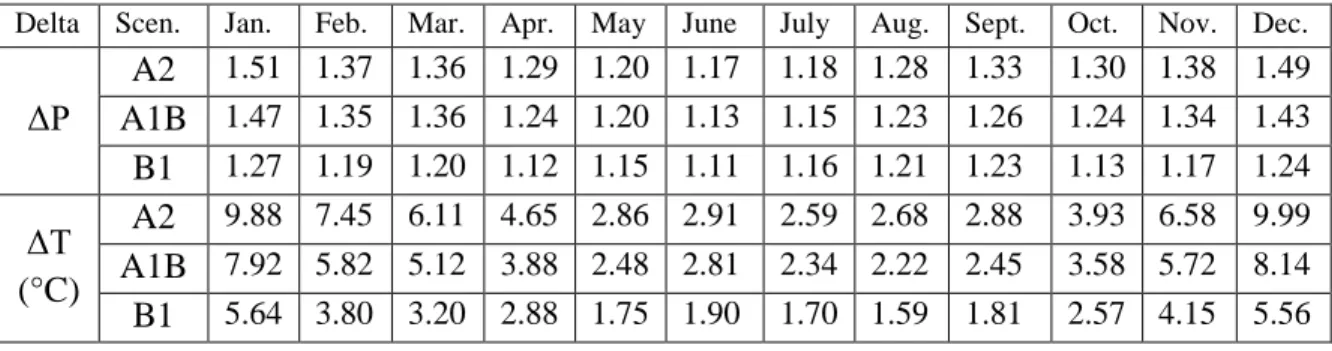
Table 4.2. Delta change factors ... 50
Table 4.3. The climate data observed for Iqaluit airport and the future climate data. ... 51
Table 5.1. Properties of the hydrogeological units ... 63
Table 6.1. Thermal and hydraulic properties of the different hydrogeological units ... 83
Table 6.2. Model parameters and associated soil layer properties ... 91
Table 6.3. Description of the designed scenarios with associated cases. ... 96
Table 7.1. Soil characteristics for the homogeneous and heterogeneous cases ... 126
Table 7.2. Physical and numerical model parameters ... 127
xi
Acknowledgment
There has been a circuitous path toward the completion of this thesis. My deep gratitude and special thanks go first to my supervisor, Prof. René Therrien for his generous support, expert guidance, consistent and constructive advice along the way that helped me to bring this study into reality and success. Without his valuable assistances, this work would not have been possible. His understanding, kindnesses and encouragement also kept me constantly engaged with my research. I am truly grateful, René, and consider myself fortunate to have had the opportunity to pursue this research study toward the PhD with you.
I would like to extend my heartfelt gratitude to Prof. John Molson, who provided this research with his numerical code and gave generously of his time involving consistent efforts to improve the code to be used for the purposes of this study. His constructive comments, and thoughtful feedback and reviews also launched a great part of this dissertation. His vast knowledge and constant encouragement also helped me to keep moving forward, despite all the ups and downs.
Thank to Prof. Jean-Michel Lemieux, who provided many useful discussions and helpful suggestions during this research that always lead me to the right sources and perspectives. He was always available for my questions and knew where to look to find a solution to the obstacles existing throughout this research.
I would like to thank the external examiners on my doctoral dissertation committee: Dr. Jeff McKenzie and Dr. Jasmin Raymond for their insightful comments, and constructive questions.
Many thanks also go to Dr. Anne-Marie Leblanc of the Geological Survey of Canada who provided me with the field measurement data and created the unique opportunity for me to travel to the north to visit the study site several times. The field work at Iqaluit airport allowed
xii
me to understand and observe visibly the challenges the Iqaluit airport is struggling with due to the thawing permafrost from climate change. Her insights, suggestions, as well as good humor were especially valuable. I also would like to thank to Prof. Michel Allard of the Centre d’Etudes Nordiques (CEN), U. Laval, who was leading the project at Iqaluit airport in collaboration with Anne-Marie LeBlanc, and provided the financial support to my travel to the north.
I am grateful to my former colleague and friends, Fabien and Jalil for their useful ideas and constant help throughout the course of this work, as well as for their good humour and relationships, which made my studies and stay abroad more enjoyable. Thanks also to my other former colleagues and friends; Tobias for good conversations and assistance as well as Nelly and Guillaume, who all together helped to sustain a positive atmosphere in which to do science.
Special appreciation to the staff and professors of the Department of Geology and Geological Engineering, including Pierre Therrien, Fritz Neuweiler, Guylaine Gaumond, Marcel Langlois, and many others for their kind help in many ways during the completion of this program.
I am extremely grateful for my brother, Reza, for his priceless help for me in finding this Ph.D. opportunity, and also for his valuable and constant guidance during my past educational explorations. I am also thankful for my sister, Neda, for her kindness and support. Above all, I would like to acknowledge with gratitude my parents, my lovely mother and father whose values, full and countless support, love, patience, wisdom and encouragement to me have always pushed me further than I thought I could go in my life.
Last but not - least, I would like to thank my beloved, Touraj, for his endless love and encouragement, who helped me survive all the stresses and difficulties throughout this entire journey, and always gave me the confidence to pursue my study. The words cannot express how grateful I am.
They all kept me going and without their support this dissertation would not have been possible.
1
Chapter 1
1
Introduction
1.1
Background
Climate change is projected to increase regional and global air temperatures and dramatically change the precipitation regime, which may in turn contribute to alter subsurface temperatures (Kurylyk et al. 2014). High latitude areas are particularly sensitive to climate-induced changes due to the existence of permafrost (Meehl et al., 2007) underlying almost a quarter of the exposed land surface area in the Northern hemisphere (Bonan, 2008). The hydrology and ecological systems of the arctic and subarctic have -significantly changed due to the climate warming (Hinzman et al. 2005, Schindler and Smol 2006). Increase in subsurface temperature resulting from climate warming, and subsequent permafrost degradation, could modify numerous hydrogeological and biological processes in these sensitive regions. Climate warming could affect groundwater flow patterns, groundwater recharge, and subsurface biological activities (McKenzie 2007). Ground water quality could be degraded, harming groundwater-dependent ecosystems. Other impacts include chemical release of carbon dioxide and methane stored in northern soil (Harden et al. 2012) as well as geotechnical failures of vulnerable northern infrastructure (Grandpre et al. 2012).
As air temperature increases, more heat will be transferred from the surface into the subsurface layers, increasing the active layer depth and decreasing the thickness of permafrost (Michel and Van Everdingen 1994). Permafrost is also expected to act like a hydraulic impedance against groundwater flow. The groundwater recharge and discharge fluxes, and their interaction with sub-permafrost aquifer is considerably impeded by the presence of the permafrost (French, 2007). However, as the confining permafrost layer begins
2
to thaw, it dramatically changes the groundwater flow regime, by increasing the recharge and discharge rate, and enhancing the hydraulic interaction between the active layer aquifer and sub-permafrost aquifer (Michel and van Everdingen, 1994). The size and extent of unfrozen zones, so-called taliks, are enlarged, which increases flow rates in the system, and consequently induces further degradation of permafrost due to advective heat transport by groundwater flow (Bense et al. 2012).
As permafrost thaws, soil permeability increases, which enhances the hydraulic interaction between shallow surface water bodies and deep flow systems, resulting in an increase in the flow rate. The overall increase in groundwater recharge will lead to further degradation of permafrost and more widespread development of taliks, which will in turn enhance the volume of groundwater discharge. The development of sub-lake taliks may generate better drainage systems, and disappearance of many arctic lakes and wetlands can be also expected (White et al. 2007, 2013; Smith et al. 2005). As recharge and discharge become more active, a higher contribution of groundwater flow in the system may also increase base flow to many northern rivers and lakes, which can impact the chemistry of their water (Michel and Van Everdingen, 1994).
Carbon stored in permafrost in the Arctic represents 40% of the global carbon (Gouttevin et al. 2012). There is an increasing concern that permafrost degradation will release carbon to the atmosphere, where additional carbon in the atmosphere will cause an increase in future global warming. Increased groundwater flow and permafrost thaw can lead to an increase in the decomposition rate of organic matter, therefore an increase in the release of methane and carbon in permafrost is expected (Romanovsky and Osterkamp 1997). Enhanced groundwater circulation from permafrost degradation can also increase the discharge of dissolved organic carbon to rivers, which would in turn increase the atmospheric carbon dioxide (Lyon et al. 2009).
Enhanced groundwater flow and permafrost degradation due to climate change can lead to geotechnical failure, by decreasing the bearing capacity of soil (Anisimov and Reneva, 2006), and can cause slope instability in permafrost regions (Zhang and Wu 2012). Thawing permafrost also brings negative consequences to ecosystems, since they become structurally
3
weak as the permafrost thaws, and converts the boreal forest to non-forested peat lands such as bogs and fens (Jiang et al., 2012a).
The geotechnical conditions of specific northern sites can be affected by permafrost degradation. Frost heave caused by increasing presence of ice can have destructive impacts on many engineered structures. Thaw settlement, also occurs due to the thawing of ice rich permafrost (Michel and Van Everdingen 1994). Occurring land settlements caused by degradation of permafrost, weakens soil properties, and can destroy buildings, roads, pipelines, railways and power lines, for which permafrost acts like a foundational settling (Jin et al. 2006; de Grandpre et al. 2012). Thus, degrading permafrost from global warming endangers the stability and vulnerability of existing roads and embankment structures in cold regions. The negative consequences caused by thawing of permafrost to the infrastructure in these regions include thaw subsidence, frost heave, frost cracks, ice wedges and surface movements, which increases road reconstruction and maintenance costs and reduces their lifetime. Infrastructure failure associated with freezing and thawing of permafrost can cause serious environmental consequences, leading to more severe road maintenance problems. In summary, climate warming in cold regions overlain by ice have raised dramatic concerns due to the sensitivity and vulnerability of subsurface environments to the changes in the ground thermal regime as a result of permafrost loss. In cold regions, due to the impermeable barrier properties of permafrost to infiltration and subsurface ground flow, its degradation, as described in detail above, has significant impacts on surface and subsurface hydrology, ecology, chemical fluxes, and may result in structural failure of critical infrastructure in these regions (Kurylyk et al. 2014). Predictions and characterization of the permafrost dynamics, surface and subsurface hydrological conditions and groundwater systems in response to climate change are important research topics that have been addressed in the framework of current permafrost studies. There is an emerging body of research exploring heat transport processes and sensitivity of subsurface thermal region to climate change. Due to the remoteness of these areas of concern, only a limited number of field investigations have been conducted. On the other hand, there has been an increasing number of studies to simulate, with analytical or numerical models, heat transfer to predict the subsurface thermal regime in permafrost environments. The following section presents a review of these studies.
4
1.2
Review of current literature
1.2.1
Analytical solutions developed for heat transport with freezing
and thawing
Analytical solutions provide direct solutions to heat transport problems. The Stefan and Neumann solutions developed in the late 1800’s are the first mathematical solutions to heat transport equations incorporating freezing and thawing processes (Lunardini 1981). These solutions have been frequently applied in many engineering applications and also by permafrost hydrogeologists to determine the ground freezing or thawing front depth in permafrost (Lunardini et al. 1981; Jumikis 1966; Harlan and Nixon 1978). The Stefan solutions are not applicable to real system physical processes because they assume homogeneous soil thermal properties, initial zero temperature and a step-change surface temperature, which is not a realistic representation of climate-induced temperature trends. Furthermore, their mathematical formulation is limited to conductive heat transport. Analytical solutions that account for heat advection via groundwater flow are presented by Nixon (1975) and Lunardini (1998). They provide an exact solution to the one-dimensional soil thawing problem including conduction, advection and phase change. However, their solution is only valid if the groundwater velocity is proportional to the rate of the thawing front penetration, which neglects the fact that vertical water flux is lower in the frozen zone due to the hydraulic impedance of ice. The Lunardini approach also assumes that the temperature distribution in the thawed zone is linear. This invoked stated-state assumption influences the Lunardini solution accuracy, since the thawing front is continuously moving downwards, and thus the thermal regime of the thawed zone will not generally achieve true steady-state (Kurylyk et al. 2014). Despite the existing limitations associated with analytical solutions, they have been applied in a few studies to simulate soil thawing (e.g. Fox 1992; Woo et al. 2004; Zhang et al. 2008).
Stefan’s equation was applied to investigate the effects of freeze-thaw processes with the HYFOR water balance model (Fox 1992). This model calculates the ground freezing and thawing front depth over time, and simulates the expanding thawing front influence on soil water infiltration, storage, evapotranspiration, and drainage. Woo et al. (2004) has also used the modified Stefan’s equation to create a two-dimensional freeze and thaw model, based on
5
heat conduction. The use of an inverted set of equations to drive the soil freeze-thaw from the bottom in their study is a significant improvement to the original freeze-thaw model of Fox (1992). As suggested by Woo et al. (2004), Stefan’s solution is applicable to areas that extend from the permafrost zone of the high arctic to the discontinuous permafrost area of the subarctic as well as low latitude areas that undergo seasonal frost.
In summary, the applications of analytical solutions to simulate the thermal regime in response to climate changes are restricted, due to the associated limiting assumptions. Some of these limitations include one-dimensional heat-flow transport, steady-state groundwater flow, homogeneous and isotropic thermal soil properties, constant pore water phase, and restrictive boundary conditions (Kurylyk et al. 2014). Although analytical equations can give reasonable results to determine the thawing front location, their applications are limited. Moisture migration towards the freezing front and the prediction of the moisture condition are not considered in analytical equations, whereas the prediction of the moisture content is very important from a hydrogeological, agricultural and ecological aspect. Most analytical soil freezing models assume that heat transfer by advection is negligible. Zhang et al. (2008) compared analytical equations and numerical models and showed that numerical models are more widely applicable since they can simulate redistribution of water during freezing and account for changes in soil thermal properties. However, analytical solutions are still applicable for benchmarking numerical models, quickly analysing an idealized system (Kurylyk et al. 2014), and the first order prediction of groundwater flow and subsurface thermal evolution (Gunawardhana and Kazama 2011; Menberg et al. 2014).
1.2.2
Numerical models of coupled groundwater flow and heat
transport
Harlan (1973) developed the first numerical solution for coupled groundwater flow and heat transport accounting for the effects of freezing and thawing. Harlan (1973) used the finite difference method to solve one-dimensional coupled heat-fluid transport equations. He concluded that the soil-water redistribution rate towards the freezing front is reduced from coarse-textured soils (e.g. sand) to fine-textured soils (e.g. silt loam), but did not compare laboratory data and analytical results.
6
Harlan’s approach was improved by other numerical models to establish a physically-based relationship between unfrozen water content and hydraulic properties (e.g. Guymon and Luthin 1974; Guymon et al 1993; Flerchinger and Saxton 1989). Guymon and Luthin (1974) developed a one-dimensional finite element heat and mass transport model. They were the first to use the finite element method to solve the same problem proposed by Harlan (1973). Fluid flow is represented as Richards’s equation and the Clausius-Clapeyron equation is used to relate the soil water freezing curve to a soil water characteristic curves through capillary theory. Guymon et al. (1993) introduced the one-dimensional FrostB model to simulate frost heave and thaw settlement for various pavement designs. The unsaturated flow equations based on Darcy’s law and the fluid continuity equation are solved to estimate moisture movement in the soil. Flerchinger and Saxton (1989) presented a one-dimensional heat and water transport model, the SHAW model, to simulate coupled heat, water and solute transfer in a snow, crop residue and soil system.
Hansson et al. (2004) presented a one-dimensional numerical model for water flow, heat and vapor transport, based on the HYDRUS-1D model (Simunek et al., 1998). The modified Richard’s equation is employed to describe water flow in variably-saturated porous media. The finite element solution is used to solve Richard’s equation and finite difference methods are applied to solve the heat transport equation for spatial and temporal discretization. Picard iteration is used to linearize the water and heat transport equations. The variations in the material properties of the soil due to freezing and thawing processes are accounted for by variations in effective permeability of the soil and water infiltration caused by the formation of ice.
Recent advances have been made toward numerical models that simulate multi-dimensional energy transport and fluid flow, and that take into account the effects of freezing and thawing. Ipprisch (2001) presented a three-dimensional finite difference model to simulate water, gas and heat transport in a permafrost environment. The results showed that that near-surface water flow plays the most important role to reduce the ice extent.
McKenzie et al. (2007) introduced a three-dimensional numerical model, SUTRA-ICE, which is a modified version of the SUTRA code (Voss et al. 1984), to simulate fully
7
saturated, coupled water and heat transport including freezing and thawing processes of pore water. The model results were verified against three-zone analytical solutions, presented by Lunardini (1985) for ice formation in a porous medium. The model has been applied to simulate the impact of ice formations and temporal changes of the thermal profile in a northern peat land. Several benchmark problems are suggested by the authors, including frozen wall problems and hill slopes with seasonal freezing. These benchmark problems can be applied to examine the validity of other numerical codes simulating coupled groundwater and energy transport.
Painter (2011) presented a three-phase numerical model MarsFlo to simulate water migration in partially saturated porous media. The integral finite-difference method with fully implicit time stepping is applied in the MarsFlo model to solve the given equations. The convergence and stability of the code were successfully tested against experimental work of Jame and Norum (1980) and Mizoguchi (1990). This model can simulate possible hydrological systems in the subsurface of Mars and Earth, in areas where the mean annual surface temperature is below the freezing point.
Rowland et al. (2011) applied the ARCHY code to assess the importance of advective heat transport and conduction in the formation of sub-lake taliks in Arctic areas. Two-dimensional heat transport and groundwater flow are coupled in this numerical model by considering the effect of water phase changes on soil permeability and latent heat content. The results highlight the important role of subsurface advective heat transport on permafrost degradation in discontinuous permafrost regions.
Coupled flow and heat transport models that simulate the impact of climate change
Zhang et al. (2008) simulated the permafrost distribution in Canada by applying a permafrost model generated by six general circulation models (GCMs). Their simulations demonstrate the transient effects of climate warming on permafrost dynamics over the 21st century. They found that in the persistent permafrost regions, thawing progresses from the top of ground surface. The simulations showed an increase in the average thickness of the active layer of 41-104%, where the depth to the thaw front increased to 1.9-5.0 m.
8
Bense et al. (2009) applied a one-dimensional model to simulate the evolution of ground-water flow in an idealized aquifer on timescales of decades to centuries in response to climate warming scenarios. The coupled transient fluid flow and heat transport equations were solved using the FlexPDE finite element software. Their simulations demonstrated that permafrost thaw as result of climate warming will lead to a sudden establishment of deep groundwater flow paths and activate the flow system. The impacts of surface water, vegetation, topography, and snow cover that can have a considerable control on subsurface ice content were not considered in this study.
Frampton et al. (2011) studied water flow in a partially frozen ground using the MarsFlo code for an increase in air temperature of 0.01 °C per year, for total simulation times of hundreds of years. The study evaluates the interactions between permafrost and near surface water flow for different surface warming scenarios. The factors considered in this study include different surface temperature regimes, variable combinations of soil types, different surface infiltration rates, and changes in the depth of the simulation domain. The simulations showed that permafrost degradation due to climate warming may dramatically affect the variability, distribution and routing of flow in subsurface and surface water systems, and can decrease the seasonal variability of groundwater discharge in permafrost settings. They also observed that as permafrost thaws, groundwater discharge initially increases, and then decreases as ice storage undergoes depletion. Frampton et al. (2013) also stated that under climate warming, groundwater discharge and river flow may decrease as a result of complete permafrost thaw. Ge et al. (2011) used the SUTRA model to assess the long-term impacts of climate change on the hydrology of permafrost under an increase in mean annual air temperature of 3°C per 100 years, including seasonal temperature fluctuations. They found that the warming air temperature can increase ground water discharge if sufficient inflow water is provided into the system to recharge the shallow groundwater system.
Rowland et al (2011) developed one and two-dimensional models to investigate the effect of sub-permafrost groundwater flow on degradation of permafrost, and to quantify the role of advective heat transport on talik development over the Seward Peninsula region, Alaska. The controls considered in this study include conductive heat transport (without sub-permafrost groundwater flow), effects of sub-permafrost groundwater, and the presence of a lake at the
9
top boundary. They found that the presence of sub-permafrost groundwater flow can lead to a great reduction in permafrost thickness due to increased permafrost thaw rates as a result of talik formation. A significant reduction was simulated in the thickness of permafrost, where there is a strong hydrologic connectivity between surface and subsurface as a consequence of climate warming. In this simulation, the presence of the near-surface ground water also dramatically intensified permafrost degradation, and permafrost was less sensitive to changes in the thermal properties of the upper-most layer. Advective heat transport by upwelling ground water into lakes is also an important process that locally reduces the permafrost thickness.
Bense et al. (2012) evaluated the impact of various permafrost conditions on hydrogeological regimes in high-latitude river basin regions, under climate warming, for an idealized topography-driven ground water system described by Toth (1963). Their studies evaluated the sensitivity of the response of the system to the initial permafrost condition, and to different combinations of aquifer permeability and specific storage. The simulations indicated that the interaction between the subsurface hydrology and climate warming is intensified, as permafrost degradation increases the permeability of the soil and enlarges the extent of taliks, which in turn increases flow rates in the system. The effect of advective heat transport by groundwater was insignificant in their study. They also demonstrated that advection-induced permafrost thaw can be activated, if the recharge is not only restricted to the precipitation. Increases in groundwater flow strongly depend on the hydraulic regime of sub-permafrost aquifer system, soil heterogeneity, and hydraulic connectivity between the taliks.
Wellman et al., (2013) applied the SUTRA model to evaluate the influence of various hydrogeological factors on sub-lake talik development in permafrost areas of Yukon Flats, Alaska. Their simulations accounted for climate changes reflective of current climate conditions, colder than present and warmer than present, incremental variation of the lake depth, hydrologic gradients (gaining lake, losing lake), and a hydrostatic lake level (zero hydraulic gradient). Their results showed that downward flushing of water in a losing lake induces faster thawing compared to systems included with gaining and static lakes, widening the talik zone, and results in higher hydraulic connectivity between supra- and sub permafrost
10
aquifers. The simulations also indicated that water exchange between the aquifer and lake increases due to advective heat transfer. They concluded that, even though climate change was considered as a prevailing hydrogeological driver, the lake size and groundwater flow also impose a major control on evolution of permafrost thaw and the formation of taliks. They further stated that the permafrost state within a cold region lake watershed will be affected and will also affect the exchange rate between groundwater and the lake, which occurs as the sub- and supra-permafrost talik evolve.
McKenzie and Voss (2013) assumed a nested groundwater system based on the classical work of Toth (1963) to investigate the influence of hydrogeological factors to degrade permafrost under climate warming scenarios. The scenarios tested in their simulations include topographic roughness, permeability and anisotropy in hydraulic properties of soil, heterogeneity in spatial distribution of permeability in forms of layers and patches, effect of surface-water bodies (lakes/streams), effect of initial permafrost temperature, impact of groundwater flow through a permafrost body, and influence of different climate-warming rate. The model showed that thaw occurs rapidly in patches with high permeability compared to low permeability patches within permafrost. Their findings showed that accounting for seasonal temperature variations can have a considerable impact on local permafrost thaw. They further demonstrated that advective heat transport can accelerate the rate of permafrost thaw to a greater extent compared to conductive heat transport only, where significant ground water flow evolves under climate warming. If a subsurface setting includes sufficient permeability to promote significant groundwater flow, further permafrost thaw can be expected under climate warming.
Kurylyk et al. (2014a) examined the climate change impacts on groundwater discharge with the SUTRA-ICE code. Seven GCM climate warming models were downscaled to provide future groundwater recharge and surface temperature variations, and were used as the model surface boundary conditions. Their simulations demonstrated that future climate warming will contribute to warming the aquifer and that the magnitude of changes depend on the configuration of shallow groundwater bodies.
In summary, as discussed above, the development of numerical models have helped explain the possible interactions between climate change, subsurface and surface hydrology systems,
11
and thermal regimes of the ground, in complex hydrogeological environments containing permafrost. The climate change impact studies discussed here highlighted the important role played by advective heat transport to dramatically increase the rate of degradation in permafrost, under increasing air temperatures. Advective heat transport by groundwater flow enhances the formation of taliks and activates previously frozen aquifers, and changes the subsurface hydrogeological, recharge and discharge rate and ground thermal regime in permafrost regions.
1.2.3
Field studies and laboratory tests
Because of the remoteness of northern areas, there is a limited number of field studies available to validate numerical models. However, the combinations of field measurement datasets with idealized numerical models would help to evaluate the performance of coupled groundwater and heat transport models designed for cold regions. The following section describes some field and experimental studies conducted in the permafrost context.
Côté and Konard (2005, 2009) experimentally evaluated the effects of soil type and structure on thermal properties in frozen and unfrozen conditions. They developed a generalized model for estimating thermal conductivity that incorporates the effects of porosity, degree of saturation, mineral content, and grain size distribution. Their model can provide thermal conductivity values for numerical analyses of heat transfer and frost propagation.
De Grandpré et al. (2010) observed that groundwater under a road embankment gradually loses heat, as it flows under the paved road, where the energy transferred by groundwater flow promotes the degradation of underlying permafrost. They found that groundwater flow is an effective factor on permafrost degradation, and should be taken into account in the road design due to embankment sensitivity to advective- heat transfer. This research was conducted based on the field measurements and geophysical surveys in Alaska Highway. Fortier et al. (2011) stated that an increasing air temperature cannot be the sole driver of permafrost degradation and that snow accumulation in embankment shoulders and toes can also act as a thermal insulator, by protecting the ground from heat loss in winter, and promoting a trend of permafrost-warming.
12
De Grandpré et al. (2012) investigated groundwater flow interaction with infrastructure within a discontinuous permafrost area. They demonstrated that conductive-advective heat transfer by groundwater flow induced a positive feedback on permafrost degradation, and that these effects increase as ice melts, due to the heat transferred by flowing water to the surrounding ground and the underlying permafrost. They emphasized that groundwater flow can have an undesirable effect on transportation infrastructure stability, thereby it must be considered during the estimation of ground thermal regimes and thaw settlement.
Watanabe et al. (2011) conducted various laboratory tests to obtain the physically-based relationships between unfrozen water content, pressure, and temperatures, based on different types of soil ranging from coarse to fine. The freezing curves obtained from these laboratory efforts can be employed in numerical studies. A similar experimental study was also recently conducted by Mohammad et al. (2014) for saturated and unsaturated soil freezing.
Comprehensive field studies in cold regions and experimental data sets related to permafrost environments are still needed to provide input parameters for existing numerical models and contribute to improve the reliability of numerical simulations (Kurylyk et al. 2014).
1.2.4
Current research needs
Permafrost degradation from climate change can cause serious environmental and engineering problems.
In addition to climate warming, certain hydrogeological and environmental factors can contribute to accelerate permafrost degradation, including snow accumulation and vegetation cover, the construction processes (e.g. changing soil properties by compaction), and ground water flow (Wu et al. 2002; Zhang et al. 2008a; Kondratiev 2009; De Grandpré et al. 2012). Models that have been recently developed to simulate coupled groundwater flow and heat transport in permafrost regions, including those of McKenzie et al. (2007), Ge et al. (2011), Frampton et al. (2011), Painter (2011), Ge et al. (2011), Bense et al. (2012), Frampton et al. (2013), and Kurylyk et al. (2014a), are valuable tools which can be applied to investigate the interactions between these factors and the thermal dynamics of permafrost.
13
In particular, advective heat transport can be important in many permafrost settings (Kane et al. 2001) such that if neglected in modelling studies (for example in Ling and Zhang, 2003; LeBlanc et al., 2015; Fortier et al., 2011)), resulting predictions of the ground thermal regime may be inaccurate. Rowland (2011), Wellman et al. (2013), McKenzie and Voss (2013), and Sjöberg et al. (2016) demonstrated that groundwater flow can affect permafrost distribution through heat advection.
They are a few recent numerical studies of coupled groundwater flow and heat transport which incorporate a complex heterogeneous geological structure within the permafrost environment (McKenzie and Voss 2013; Bense et al. 2012). Although the freezing function depends strongly on the soil type (see experimental work of Watanabe, 2011), in most studies it is considered uniform, despite the natural soil heterogeneity.
In summary, although there are many ongoing numerical studies to explore the interaction between climate change and permafrost dynamics, there are still many gaps and a lack of knowledge in existing research to improve the understanding of the subsurface thermal regime in response to climate warming. For example, although the current permafrost models comprise the complex features of ice-water dynamics, they have been rarely calibrated against field data, due to the remoteness of the area of interest, and inadequacy of field observations in cold regions. Despite the importance of advection on transporting heat, it has been neglected from certain numerical studies. Despite the effects of complex heterogeneous geological formations on controlling groundwater flow, it has been absent from the most of the studies due to the additional complexity that it adds to the system. Snow accumulation at the surface has been underestimated in many numerical predictions, even though it may impose an equally strong control as climate change on timing and rate of permafrost thaw as well as ground water-ice dynamics. Therefore, the potential effects of contributing hydrogeological factors on permafrost degradation under the climate warming should be still characterised and quantified in well-tested numerical models, with which the important future predictions, expansion and solutions can be made against the destructive effect of thawing permafrost to infrastructure, in sensitive northern areas. Identifying the important hydrogeological controls on permafrost degradation would also help other studies to identify the critical hydrogeological factors in their simulations.
14
Thus, a comprehensive understanding and a more reliable prediction of permafrost behaviour due to climate variations will demand additional research and improvements, including the inclusion of advective heat transport in large-scale studies of cold regions, and the comparison of numerical simulations against the observed field measurements (Kurylyk et al. 2014). Ireson et al. (2013) pointed out that modelling of field-scale behaviour of seasonal freeze-thaw processes is still a major challenge in cold region research. They suggested that improvements can be made by combining modelling studies with well-designed field experiments.
1.3
Research objective and methodology
The principal objective of this study is to help fill the knowledge gap in the understanding of subsurface thermal regimes in response to climate warming, by addressing the impact of hydrogeological factors on permafrost degradation in a cold-region paved terrain, under future climate scenarios proposed by the Intergovernmental Panel on Climate Change (IPCC, 2007).
A series of numerical simulations of coupled groundwater flow and heat transport have been developed to assess the effects of realistic combinations of hydrogeological parameters and surface conditions on the temporal and spatial evolution of permafrost degradation.
An idealized conceptual model was first developed, based on the subsurface and surface hydrogeological characteristics and climate conditions at the Iqaluit airport, which is undergoing site characterization to investigate the impact of permafrost degradation on the runway infrastructure. The conceptual model assumes that current conditions are representative of a cold-region paved terrain. Based on the conceptual model, a numerical model was developed and calibrated to reproduce measured ground temperatures at the Iqaluit Airport. The calibration was conducted in order to ensure that the designed model is representative of the study site. This calibrated model was then used as the basic reference model for subsequent simulations that test a series of simulation cases aimed at investigating the interaction between various hydrogeological controls and permafrost thaw under climate change. Estimates of ground settlement induced by permafrost thaw are also provided.
15
The numerical model applied in the present study is the HEATFLOW/SMOKER code (Molson and Frind, 2015), which was verified against several analytical benchmark problems. The advantage of this numerical code to be employed in this contribution is that it can simulate density-dependent groundwater flow coupled with heat transport. The present model also incorporates freeze/thaw processes and water-ice phase change and accounts for latent heat effects.
The various tasks (numerical simulations) accomplished in the framework of this doctoral project, are summarized as follows:
1) Verification of the code against analytical solutions 2) Verification of the code for thaw settlement
3) Calibration
4) Sensitivity analysis
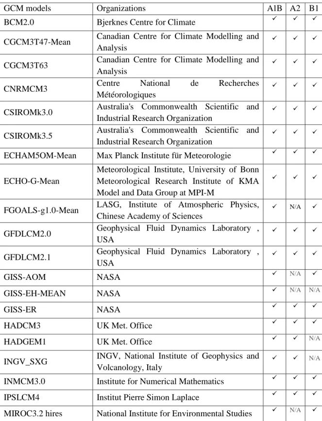
5) Generation of climate change data using 24 different GCM models (global circulation models form IPCC 2007)
6) The role of groundwater flow: the relative effect of advective versus conductive heat transport
7) The role of the unsaturated zone: unsaturated zone versus fully saturated system 8) The impact of snow accumulation on the taxiway shoulders: winter snow-covered
system versus a snow-free system
9) Prediction of thaw settlement and frost heave during the phase transitions
10) The effect of the freezing function: steep freezing function versus a smooth freezing function
11) The effects of a heterogeneous hydraulic conductivity: homogeneous system against a heterogeneous soil
The content of the present thesis consists of eight different chapters. The current chapter provided a literature review and an overview of the present PhD research background and the research objective. Chapter 2 introduces the study site, Iqaluit airport, Nunavut, Canada with the current challenges and problems associated with permafrost degradation in this area. Chapter 3 presents the numerical model employed in this study to understand permafrost behaviour in a cold region terrain. Chapter 4 gives details on climate data derived from GCM
16
models. Chapter 5 is a conference paper (Ghias et al. 2015) presented in GeoQuébec 2015: 68th Canadian Geotechnical Conference and 7th Canadian Permafrost Conference, entitled “Numerical simulations of coupled groundwater flow and heat transport incorporating
freeze/thaw cycles and phase change in a continuous permafrost environment”. Chapter 6 is
a journal paper (Ghias et al. 2016), accepted for publication in Hydrogeology Journal whose title is “Controls on permafrost thaw in a coupled groundwater-flow and heat-transport
system: Iqaluit Airport, Nunavut, Canada”. Chapter 7 is a journal paper entitled “Numerical simulations of heat transport in heterogeneous groundwater flow systems within a continuous permafrost setting” (Ghias et al. 2016) that has been submitted to the Canadian
Geotechnical Journal. The papers in Chapter 5, 6, and 7 present various numerical simulations that were tested to address the interaction between hydrogeological factors (items 3-12 in the list aforementioned) and permafrost, under climate warming. The last chapter concludes this work, discusses perspectives and provides insight on potential future research in the field of permafrost modelling.
17
Chapter 2
2
Study Site
2.1 Location
The Iqaluit Airport (63° 45′ N, 68° 33′ W), is located in Iqaluit, Nunavut, Canada, at the south-eastern part of Baffin Island (Figure 2.1) . The airport is built on a flat terrain located above a succession of glacial deposits, and is surrounded by hills and rocky plateaus of the Precambrian Shield, within continuous permafrost.
18
Figure 2.1. a) Geological location of the Iqaluit Airport, Nunavut, Canada, at the south-eastern part of Baffin Island at the head of Frobisher Bay (63° 45′ N, 68° 33′ W). b) Taxiway Alpha and the location of the 2-D cross-section transverse to the taxiway, which is the focus of the present study.
19
2.2 Current issues related to thawing of permafrost
Permafrost thawing at the Iqaluit Airport as a result of climate warming has become a major threat to the stability and vulnerability of existing roads and embankment structures. The subsidence resulting from permafrost thaw, as well as frost heave, frost cracks, dense networks of ice wedges, and surface movements have recently increased the maintenance and reconstruction costs of roads, and have decreased the road infrastructure life expectancy. The Iqaluit Airport infrastructures are key strategic assets that need to be well-maintained in order to develop the Canadian Arctic. The ongoing mineral exploration and development in the Arctic are placing new pressures on these key regional infrastructures, which need to be characterized (Leblanc, 2014). Field investigations have been initiated in 2012 in collaboration between the Canada-Nunavut Geoscience Office (CNGO), Natural Resources Canada (NRCan), and Université Laval Centre d’études nordiques (CEN). Ongoing field investigations at the Iqaluit Airport in Nunavut, Canada, are aimed at investigating factors that control freezing and thawing cycles of permafrost, which threaten the stability of existing runways, taxiways, aprons and access roads. However, despite the ongoing field investigation at the study site, a comprehensive understanding of the interactions between physical and thermal properties and permafrost dynamics in the context of climate change necessitates the application of numerical models. The simulation results can increase the understanding of interaction between subsurface thermal regimes and effective environmental and hydrogeological factors, and can support engineering road designs and management decisions for the forthcoming years, in order to adapt a more efficient infrastructure design against the challenges caused by thawing permafrost.
2.3 Field investigations and observed data
Field characterization of permafrost has been conducted since 2010 at the Iqaluit Airport. The subsurface has been characterized with a series of geophysical methods, including ground penetrating radar, electrical resistivity and interferometric synthetic aperture radar (InSAR). A series of boreholes, shown in Figure 2.2, were also drilled. Soil and permafrost samples were recovered from boreholes for laboratory analyses and several boreholes were
20
equipped with thermistor cables, thaw tubes and pressure transducers (Allard et al., 2012; LeBlanc et al., 2012, 2013; Short et al., 2012, 2014; Mathon-Dufour, 2014; Oldenborger et al., 2014). The field data collected include surface and subsurface temperatures, snow depth (Leblanc et al. 2014), stratigraphy including soil unit characterisations, soil particle distributions (Mathon-Dufour, 2014), and estimated unfrozen water content changes in borehole (Oldenborger et al., 2014).
21
Figure 2.2. a) Location of the 23 boreholes drilled at the Iqaluit Airport in 2010, 2011 and 2012, b) location of the boreholes equipped with thermistor cables., and c) temperature profiles measured with thermistor cables located at natural ground (IQA_DDH_02), paved runway (IQA_AERO_DDH_01) and paved apron (IQA_AERO_DDH_03), (Mathon-Dufour, 2014).
22
2.4 Climate data
The observed mean annual air temperatures and total annual precipitation for Iqaluit Airport during the period of 1971-2012 were provided from the online database available on the Environment and Climate Change Canada website, for an adjacent station (IQALUIT A) (Figure 2.3). The mean annual air temperature for the period 19712012 is estimated to be -9.1 ˚C, and the minimum and maximum mean monthly temperatures were -33.9 ˚C and 10.7 ˚C, respectively. For the same period, the mean annual precipitation including rain and snow was 420 mm, 48% of which occurred as rain. The mean annual air temperature of Iqaluit has been rapidly increasing since 2000, and in 2010 the mean annual air temperature reached a peak of about -4 ˚C.
Figure 2.3. The mean annual air temperature and annual precipitation variations, observed for the study site, Iqaluit Airport for the period of 1971-2012. The data are extracted from the online database available on the Environment Climate Change Canada website.
23
2.5 Geology and hydrogeology
The surficial geology of the region (Allard et al. 2012) indicates that nearly 67% of the length of the airport runway is built on glaciomarine delta deposits, composed of sand, silt, boulders, and gravel. The runway, aprons, and access road were first built during World War II. After 1948, the runway was extended at the north–west end onto a glaciofluvial outwash deposit and bedrock. Till and marine veneer covered the surrounding terrain of the airport (Figure 2.4). A dense network of ice wedge polygons exists on the glaciomarine delta deposits, which affects the performance of the runway shown in Figure 2.4. Alluvial channels and lacustrine deposits are present under the embankments of the Taxiway, which is the focus area of this study.
24
Figure 2.4. Surficial geology of the study site, Iqaluit Airport (Allard et al. 2012). The extent of the main and access roads, and the apron at the Iqaluit Airport is indicated as a red line.
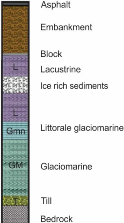
The different deposits extracted from borehole drilling (location shown in Figure 2.2) on the Taxiway are presented in Table 2.1 and Figure 2.5. The drilling advanced until 8.1 m, until the bedrock was reached. This borehole intersects four stratigraphic units resting on the bedrock. From the base to the surface, these units are: 1) glacial till consisting of angular fragments, 2) laminated clay, 3) laminated and oxidized fine sands, and 4) laminated clayey silt with some gravel.
25
As shown in Figure 2.5 and Table 2.1, the stratigraphy starts with bedrock at the bottom, overlaid by a thin layer of till with a thickness of approximately 0.5 m, which is covered by a glacial marine unit characterized as fine-grained deposits with a thickness of about 2 m. A thin layer of lacustrine deposits composed of silt underlies the marine deposits, and is overlain by an embankment layer with a thickness of about 2 m. The thickness of the active layer ranges between 2 -2.5 m.
Figure 2.5. Schematic stratigraphy of the deposits extracted from borehole drilling on Taxiway Alpha (Mathon-Dufour, 2014).
26
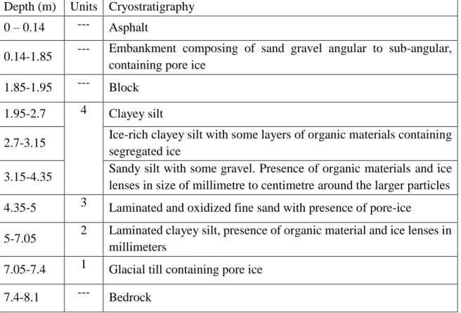
Table 2.1. Soil characteristics obtained from borehole analysis presented by Mathon-Dufour (2014)
Depth (m) Units Cryostratigraphy 0 – 0.14 --- Asphalt
0.14-1.85 --- Embankment composing of sand gravel angular to sub-angular, containing pore ice
1.85-1.95 --- Block 1.95-2.7 4 Clayey silt
2.7-3.15 Ice-rich clayey silt with some layers of organic materials containing segregated ice
3.15-4.35 Sandy silt with some gravel. Presence of organic materials and ice lenses in size of millimetre to centimetre around the larger particles 4.35-5 3 Laminated and oxidized fine sand with presence of pore-ice
5-7.05 2 Laminated clayey silt, presence of organic material and ice lenses in millimeters
7.05-7.4 1 Glacial till containing pore ice 7.4-8.1 --- Bedrock
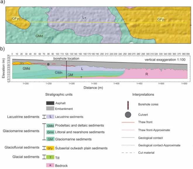
The stratigraphy along Taxiway Alpha at Iqaluit Airport is presented in Figure 2.6, which was developed from borehole analysis and geophysical investigations. The stratigraphic units consist of granite-gneiss bedrock (R), till (T), glacial fluvial sediments (GFP), glacial marine sediments (GM), littoral near shore sediments (GMn), deltaic sediments (GMd), and lacustrine lake sediments (L).
According to borehole drilling conducted at the Taxiway (Figure 2.5), the bedrock (R) located at the eastern end of the profile, between the distance of 1+260 and 1+ 560, is characterized as an ancient rocky outcrop, which was removed by blasting to construct the access road. The depth of the bedrock at this location is between 2.5 and 3 m. North of the access road, between distances of 1+260 and 1+400, the depth of the bedrock, following the slope of the rocky outcrop, is between 7.5 and 15 m. The bedrock is overlain by a typical sedimentary layer of sub-glacial till with a thickness of approximately 0.5 m, covered with a
27
glacial marine unit (GM) consisting of clayey silt about 2 m thick, which was deposited during the marine transgression accompanying glacial retreat.
The next unit is a coastal sands deposit (GMn) with a thickness of approximately 0.6 m. Above this layer, the coastal unit is lacustrine, located between the distance of 1+250 and 1+420 with a thickness of about 2 m. This deposit consists of ice-rich clayey silt and corresponds to the location of a pre-existing lake.
A glacial marine unit is located in the western part of the access road between 1+170 and 1+250, and it is covered by glaciofluvial deltaic unit (GFp). The road embankment materials are categorized as sand and gravel with an average thickness of about 2 m, which is covered with a thin layer of asphalt of about 15 centimeters.
28
Figure 2.6. Geological cross section constructed along the center of Taxiway Alpha (Mathon-Dufour, 2014). a) Location of cross-section on geological map, and b) geological profile of the center of taxiway.
Figure 2.7 shows the hydrographic network of Iqaluit Airport representing several streams, drainage ditches, Carney Creek River that flow through town, and several small lakes, some of which occupy kettles. The main flow follows the topography and occurs generally from north to south towards Frobisher Bay. The road extension built in 1958 in the northern sector of the runway affected the natural drainage system (Mathon-Dufour, 2014).
From 1948 to 2006, the natural drainage system was dramatically changed by human activities, including drainage of the lake to build up the taxiway and construction of drainage
29
ditches (Figure 2.7a,b). Embankments were dumped over lakes and small streams were filled. For example, a main channel of Carney Creek was first naturally flowing at the east of the runway (Figure 2.7a), and later on, during the road construction, this channel was filled and redirected further east at the back of Apron I (Figure 2.7b). Several water features were diverted from their original course or backfilled to allow construction of infrastructure, especially during the extension of the runway towards the end of 1950. A lake 175 m long and 75 m wide was drained in order to build the access road Alpha. About 500 meters of Carney Creek, which flows through the city and originally was flowing under the current infrastructure, was later diverted and channeled to build up the aprons and access roads (Figure 2.7b). The field investigation demonstrates that the pre-existing lake and one small stream affect the stability of the largest apron and one of the main access roads, by inducing frost cracks and thaw subsidence related problems (Mathon-Dufour, 2014).
30
Figure 2.7. Changes in hydrographic network of Iqaluit Airport from its origin a) before construction in 1942, and b) after construction in 2006 (Mathon-Dufour, 2014).
There is lack of information on the hydrologic properties of the study site. As observed in the ongoing field investigations (Mathon-Dufour 2014), a layer of ice (permafrost table) at the base of the active layer and a long zero curtain period in early winter, confirm the presence of groundwater in problematic sectors at the site, where the permafrost temperature is measured to be the highest. . The presence of natural permeable materials in the structure of the embankment, including very coarse sand and gravel without a fine matrix, may enhance groundwater flow. The geophysical investigation suggested the presence of groundwater, and suggested that groundwater accumulates in the active layer over the permafrost table in summer, some of which seeps along the margins of the runway forming settlement cavities at the edge of the runway shoulder, and freezing processes returns back during the winter. As observed in the ongoing field investigations (Mathon-Dufour 2014), an important volume of
31
groundwater can infiltrate into the soil through the network of frost cracks appeared along the runway. Freezing and thawing cycles of the active layer are highly responsible for the annual heave and thaw recorded by geophysical surveys (interferometric synthetic aperture radar mapping) and field measurements at Iqaluit Airport. The field observations suggested that the most sensitive areas currently affected by the presence of groundwater flow are where the pre-existing lake and river were backfilled to expand the apron and the runway. Groundwater flow from pre-existing lakes and streams in the embankment during the summer thaw washes the fine soil particles from within the road fill materials, which are loosely compacted, resulting in extensive road-associated problems (Mathon-Dufour 2014).