Updating prior geologic uncertainty with GPR traveltime
tomographic data
J. Lopez-Alvis, Urban and Environmental Engineering, University of Liege,
F. Nguyen, Urban and Environmental Engineering, University of Liege,
T. Hermans, Department of Geology, Ghent University
Key words: uncertainty, GPR tomography, multiple-point geostatistics, Bayesian
Introduction
In a Popper-Bayes approach, the prior probability states the initial degree of uncertainty, which should be taken very large, and the collected data should only be used to falsify unlikely scenarios [1]. In this context, geophysical methods provide data sets limited in reso-lution but with relatively large spatial extent enabling to narrow the uncertainty of the prior.
Geological scenario is one of the uncertain parameter often neglected in uncertainty analysis. It can be rep-resented through training images from which multiple-point geostatistics (MPS) simulations can be drawn. Generating multiple simulations within each scenario enable us to consider within-scenarios spatial uncer-tainty [2].
GPR traveltime tomography is sensitive to porosity variations and hence it might assist in obtaining a spa-tial distribution of facies. The method provides good resolution in imaging structures with high wave veloc-ity which also makes it suitable to identify continuveloc-ity patterns. It is also the starting model for more complex full waveform inversion which cannot work without it and where uncertainty has been seldom investigated.
When simulating flow and transport in the subsur-face, identifying preferential flow paths is necessary and their magnitude can be quantified using connectivity metrics [3]. When updating the prior uncertainty using geophysical data it might be useful to compare different scenarios based on its connectivity.
This work aims at using GPR traveltime data to up-date the prior probability distribution using two dif-ferent distance definitions: the Euclidean distance and one based on connectivity metrics. By doing this we can assess the value of this geophysical method in up-dating prior uncertainty and also compare the effect of the two distances for this type of data.
Methods
We follow a similar approach to [4]. Within a Bayesian framework, applying this methodology results in an up-dated prior that can be later used to obtain a posterior distribution constrained to dynamic data. In this way, geophysical data are used to falsify/validate the prior geologic uncertainty.
The updating process (Figure 1) consists of the fol-lowing steps:
(1) Defining a wide prior distribution f (p) taking into account uncertainty in both continuous and dis-crete parameters p, e.g. geometrical parameters and depositional environments. We use training images and MPS simulations to model this uncertainty.
(2) Transforming the facies distribution into a distri-bution of geophysical properties, by using petrophysi-cal relations which can also include uncertainty (either on the parameters of the relation or the relation itself). Forward modeling of GPR traveltimes in each of these simulations is applied to get the geophysical response
(1) (2) (3) (4) f(p) prior probability distribution
Forward modeling and data transformation
Comparison using distance function and low-dimensional space f(p|d) updated prior probability distribution dobs dsim MPS simulation facies distributions
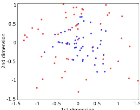
0 0.5 1 1.5 -0.5 -1 -1.5 -1.5 -1 -0.5 0 0.5 1 1st dimension 2nd dimen sion
Figure 2: MDS plot showing similarity of the GPR response using facies simulations with two different scaling factors: big channels (red) and medium channels (blue)
and additionally some data transformation can be used (e.g. regularized inversion).
(3) Computing of distances between any two models (including the model from observed data) using the Eu-clidean distance and a distance based on connectivity metrics. We then use multi-dimensional scaling (MDS) to project these distances in a lower dimensional space (Figure 2).
(4) Estimate probability density f (d|p) in this lower dimensional space by using kernel smoothing [1] and calculating f (p|d) through Bayes’ rule.
Results
We generate prior probability distributions consider-ing uncertainty in several parameters includconsider-ing geolog-ical scenario, geometrgeolog-ical properties and petrophysics. This contrasts with other studies where only one type of uncertainty is considered (e.g. [1, 4]). MPS sim-ulations are generated and one of them is chosen as the true model. Then the methodolgy is evaluated in terms of its ability to constrain uncertainty around this model.
Using GPR traveltime tomography to update prior uncertainty shows that this method is more discrimi-nant than other methods (e.g. surface ERT [4]), mean-ing that GPR traveltime data further reduce prior spa-tial uncertainty. Regarding uncertainty in geological scenario, GPR tomography results in more scenarios getting falsified. When considering alternative petro-physical relations and different values for the param-eters of these petrophysical relations, GPR traveltime data significantly reduce the prior uncertainty.
As previously suggested, the methodology can be used to compare different geophysical methods in terms of their ability to narrow prior uncertainty, e.g. ERT versus GPR, or traveltime tomography versus full waveform inversion. It is also possible to integrate time-lapse data in the workflow, which leads to fur-ther constrain of prior uncertainty and is particularly beneficial if this uncertainty is to be considered for dy-namic modeling of a related process.
References
[1] H. Park, C. Scheidt, D. Fenwick, A. Boucher and J. Caers. History matching and uncertainty quantification
of facies models with multiple geological interpretations, Comput. Geosci., 17, 609–621, (2013).
[2] L. Feyen and J. Caers. Quantifying geological uncer-tainty for flow and transport modeling in multi-modal heterogeneous formations. Adv. Water Resour., 29(6), 912–929, (2006).
[3] P. Renard and D. Allard. Connectivity metrics for sub-surface flow and transport. Adv. Water Resour., 51, 168–196, (2013).
[4] T. Hermans, F. Nguyen and J. Caers. Uncertainty in training image-based inversion of hydraulic head data constrained to ERT data: Workflow and case study. Water Resour. Res., 51, 5332–5352, (2015).