Ce document a été numérisé par la Division de la gestion des documents et des archives de l’Université de Montréal.
L’auteur a autorisé l’Université de Montréal à reproduire et diffuser, en totalité ou en partie, par quelque moyen que ce soit et sur quelque support que ce soit, et exclusivement à des fins non lucratives d’enseignement et de recherche, des copies de ce mémoire ou de cette thèse.
L’auteur et les coauteurs le cas échéant conservent la propriété du droit d’auteur et des droits moraux qui protègent ce document. Ni la thèse ou le mémoire, ni des extraits substantiels de ce document, ne doivent être imprimés ou autrement reproduits sans l’autorisation de l’auteur.
Afin de se conformer à la Loi canadienne sur la protection des renseignements personnels, quelques formulaires secondaires, coordonnées ou signatures intégrées au texte ont pu être enlevés de ce document. Bien que cela ait pu affecter la pagination, il n’y a aucun contenu manquant.
NOTICE
This document was digitized by the Records Management & Archives Division of Université de Montréal.
The author of this thesis or dissertation has granted a nonexclusive license allowing Université de Montréal to reproduce and publish the document, in part or in whole, and in any format, solely for noncommercial educational and research purposes.
The author and co-authors if applicable retain copyright ownership and moral rights in this document. Neither the whole thesis or dissertation, nor substantial extracts from it, may be printed or otherwise reproduced without the author’s permission.
In compliance with the Canadian Privacy Act some supporting forms, contact information or signatures may have been removed from the document. While this may affect the document page count, it does not represent any loss of content from the document.
Lighting the Wine Dark Sea, A Typology of Ancient Lighthouses Based on Archaeological Evidences
par
Renée A Bouchard
Centre d'études classiques Faculté des arts et des sciences
Mémoire présenté à la Faculté des études supérieures en we de l'obtention du grade de maîtrise
en études classiques option archéologie classique
avril 2007
« copyright », Renée A Bouchard
Ce mémoire intitulé: Lighting the Wine Dark Sea, A Typology of Ancient Lighthouses Based on Archaeological Evidences
Présenté par : Renée A. Bouchard
a été évalué par un jury composé des personnes suivantes :
Christian Raschle président-rapporteur Pierre Bonnechere directeur de recherche Beaudoin Caron membre du jury Jane Francis membre du jury
En effectuant une étude comparative de vestiges archéologiques de certains phares dans l'antiquité, ce mémoire tente d'établir une typologie des phares anciens.
Le travail comporte 2 volets:
Le chapitre 1 procède à des études individuelles sur chaque phares sélectionnés abordant certains aspects prédéterminés tel: la localisation géographique et physique, le contexte, l'histoire, le plan, les dimensions, les matériaux de construction, la présence de statuaire ou inscriptions religieuses ainsi que les combustibles. Les phares représentés sont: Boulogne-sur-Mer, Féjus (la Lanterne d'Auguste et le phare de]a Butte Saint-Antoine), Dover (Eastern Pharos et Western Pharos), Ostie, La Corufta, Cherche l, Leptis Magna et Pharos.
Le chapitre 2 conduit des études comparatives analysant entre eux les différents aspects abordés dans le chapitre 1. Il offre ensuite une typologie qui, d'après les résultats obtenus dans ce chapitre, se base sur la morphologie et la localisation physique des phares dans l'antiquité.
Des illustrations pertinentes au travail viennent compléter ce mémoire. Les résultats engendrés par cette étude nous démontrent, que dans la plupart des cas, la forme et le plan des phares semblent être influencés non pas par l'environnement géographique mais par l'environnement physique.
This memoir proposes to conduct a comparative stu<!r based on archaeological evidence of sorne ancient lighthouses erected between the 3 century BC and 2nd century AD in order to establish a typology.
In chapter l, a study of specific lighthouses examines details such as location, context, history, shape, dimensions, construction material, statuary and religious inscription, fuel as well as function. The lighthouses investigated are: Boulogne-sur-Mer, Frejus (2) (Lanterne d'Auguste and Butte Saint-Antoine), Dover (2) (Western Pharos and Eastern Pharos), Ostia, La Coruiia, Cherche l, Leptis Magna and Pharos. They were selected on the basis oftheir archaeological evidence.
Chapter 2 consist of a comparative analysis, topic by topic, of the
above-mentioned lighthouses in order to propose a tentative typology based on the morphology of lighthouses and their physical environment.
Illustrations and geographic maps complete this work.
The results yielded by this study show that the morphology of lighthouses are more likely to be dictated by the physical environment than their geographic locations.
Chapter 1 - Individual studies of selected lighthouses:... ... ... ... ... ... ... ... ... ... ... p.5 -Eastern Pharos (Cat. 1)
-Western Pharos (Cat. 2) -Boulogne-sur-Mer (Cat. 3) -Lanterne d'Auguste (Cat. 4) -Butte Saint-Antoine (Cat. 5) -Ostia (Cat. 6)
-La Corufia (Cat. 7) -Cherchel (Cat. 8) -Leptis Magna (Cat. 9) -Pharos (Cat. 10)
Chapter 2 - Comparative studies of data: ... p.39 -General distribution
-Distribution within site -Building materials -Statues and epigraphy -Chronology
-Patrons and builders -Lighting and Fuel -Functions .
-Conc1usion and typology
Conclusion ... p.55 Illustrations (see Illustrations list) ... p.57 Bibliography ... p.8l
Fig. 2 Reproduction of the lighthouse at Boulogne-sur-Mer based on 16th century
sketch by geographer Beaurain.
Fig. 3 Commodus medal representing lighthouse at Boulogne-sur-Mer.
Fig. 4 Later engraving of the lighthouse at Boulogne-sur-Mer with area showing
the surroundings and the coast of Britain.
Fig. 5 Peutinger Map showing the lighthouses ofOstia (above) and Pharos (below). Fig. 6 Harbour at Frejus recreated by artist Jean-Claude Golvin.
Fig.7 Lanterne d'Auguste.
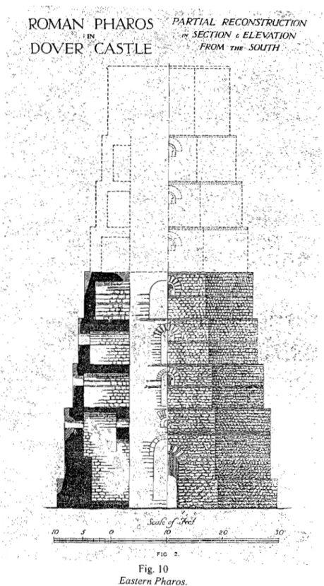
Fig. 8 Archaeological drawing of Butte Saint Antoine. Fig. 9 Plan of Do ver /rom the "Office of the Works". Fig. 10 Eastern Pharos.
Fig. Il Floor plan of Eastern Pharos.
Fig. 12 Plan ofupper level altered du ring medieval times.
Fig. 13 Stamp from Classis Britannica bearing inscription CL.BR.
Fig. 14 Remaining part of the Western Pharos as part of the walls of the army barracks
at Dover.
Fig. 15 The stratafrom the excavation of the Western Pharos. Fig. 16 Plan ofOstia.
Fig. 17 Photo of con crete base of lighthouse at Ostia. Fig. l8Mosaicfrom l'Isola Sacra, Ostia.
Fig. 19Mosaicfrom The Place of Corporations, Ostia. Fig. 20 Harbour at La Coruna.
Fig. 24 Harbour at Cherche/.
Fig. 25 Floor plan of the lighthouse at Cherche/.
Fig. 26 Archaeological evidence from the lighthouse at Cherche/.
Fig. 27 Plan of the harbour of Leptis Magna.
Fig. 28 Reconstruction of the lighthouse at Leptis Magnafrom R. Bartoccini.
Fig. 29 Harbour at Alexandria.
Fig. 30Modem Fort Qaitbay.
Fig. 31 Reconstruction of the lighthouse at Pharo.
Fig. 32 Reproduction section of the lighthouse at Pharos. Fig. 33 The Begram Vase.
Fig. 34 Two coins from Pharos.
INTRODUCTION:
According to the Concise Oxford Dictionary (1982,582), a lighthouse is a: "tower or other structure containing beacon light to wam or guide ships at sea". For the purposes ofthis study, these are the elernents which will determine what lighthouses will be reviewed in this thesis: an architectural entity with a beacon used to guide ships.
Ancient lighthouses are constructed out of stone and brick. They take the form of a tower, but can be of different shapes: octagonal, square, round, and rectangular. The beacon is located at the top, sometimes in a cupola. Inscriptions were embedded in the walls of sorne lighthouses and frequently name the builder and/or a dedication to a deity. Images oflighthouses on Greek and Roman coins, glass vessels, and mosaics show that they often inc1uded statuary decoration of emperors and/or deities. Lighthouses are located variously at the entrances ofharbours, usually at the end ofbreakwaters, or on isolated c1iffs above the coast, approximately a few kilometers from the harbour installations.
The first evidence for lighthouses in the Ancient Mediterranean cornes in Homer's Iliad
"Then he took up the great thick shield, which flashed in the distance like the moon, or like the gleam that sailors catch at sea from a fire on a lonely upland ... " (Homer, Iliad XIX-375). This is not strictly a lighthouse but acts as an aid to navigation and fulfills the same function.
Archaeological evidence for lighthouses begins in the 6th cent.
Be
with a structure at Thasos in Greece (Empereur, Archontidou-Argyri, Simossi 1989,51-59). This small tower, made out of stones, measures approximately l.50m. The beacon, located on the top, is accessed by a ladder (Fig. 23). Very few of these early aids to navigation survive, but it is also probable that major harbours like Piraeus featured lighthouses.The lighthouse built at Pharos marked a turning point in lighthouse technology. The solid structure made of granite and measured approximately 130m in height. A concession to
aerodynamics can be observed: the lower level was square but the upper receding levels were octagonal and cyl indri cal. At high altitudes, were wind is prevalent, these shapes offered less resistance. Pharos seems to have established sorne guidelines which were going to be observed from then on: the receding levels and the aerodynamic shape.
The Roman world saw the inclusion of many lighthouses as a common feature of harbours. These lighthouses occur in nurnerous configurations, building materials, sizes, and often display decorative features. Despite these differences, they aIl serve the same purposes, and at least sorne of the Roman examples show a consistency of construction as weIl.
The visibility ofthese beacons is difficult to gauge, although Josephus claims that the Pharos at Alexandria could be seen at 60 kilometers away or "three hundred furlongs away" (Josephus, Jewish Wars IV-612). These obviously would have required huge amounts of fuel.
Precise details are unavailable but options would have included olive oil, pitch, coal, and petr01eum by-products (Greek fire).
Despite the importance of lighthouses in ancient seafaring, few physica1 remains are available for study. The location of lighthouses, often at the edge of cliffs, and their great height make them fragile and prone to disasters, such as tsunamis, earthquakes and erosion. Their primary use can also be altered and their shapes distorted over time, making their identification and also study particularly difficult.
Aiso lacking is the ancient testimonia, which tends to be of a very general nature, even when a specifie lighthouse, like the Pharos, is mentioned; nonetheless, these do not always provide detailed data permitting a reconstruction. Authors like Pliny the EIder (XXXIV-83), Josephus (Jewish Wars IV-612), and Suetonius (Caligula 46 and Claudius 20) refer to lighthouses in this general manner.
Secondary scholarship on specifie lighthouse sites is frequently vague and sel dom conclusive. Several publications, however, are noteworthy and useful. In the 19th century, Jean Allard, a lighthouse engineer appears to have been the first to address the subject (Allard 1898). In 1909, a German archaeologist, Hermann Thiersch (Thier'sch 1909), wrote a monumental opus on the lighthouse of Pharos. This lighthouse is today under excavation by Jean-Yves Empereur and an underwater team (Empereur 1998). Michel Reddé established a "typology" of ancient lighthouse from representations on in the pictorial arts (Reddé 1979).
The material addressed in this thesis ranges from the 3rd century BC into the 2nd century AD. Ail classes of evidence are considered, where available. Not every extant lighthouse has been included, and the ten examples were selected on the basis of availability of primary and
secondary evidence; this study is ongoing and further lighthouses will be added in future research.
The first chapter presents the archaeological evidence. This inc1udes a brief catalogue entry for each lighthouse that contains data such as chronology, location, material, and shape. Following each entry is a discussion of the lighthouse, with focus upon its particular issues. These are presented by continent (Europe, North Africa), and then by country, moving from the northem most Roman province to the south (Britain to Egypt).
Chapter 2 contains comparative analyses of the data in Chapter land proposes a tentative morphological typology based on the results ofthese analyses.
known), dimensions (ifknown), statuary decoration and epigraphical evidence. Also included are the primary and secondary sources pertinent to each example as well as the illustration included in the Appendix of this thesis.
Europe
England: Dover (Ancient Dubris)
Dover preserves remains oftwo ancient lighthouses: the Eastern or Castle Pharos, and the Western Pharos. Both lighthouses once dominated the cliffs ofDover
1. Eastern or Castle Pharos
Location: Cliff, ca. 1.3krn east of Roman harbour; 23m from cliff edge; 116m above sea level.
Patron: Unknown
Shape: Octagonal
Materials: Mortar and bricks with imported green stone facing
State of Preservation: Lower 13m (Roman); later incorporated into church of St. Mary Fuel: Date: Dimensions: Sculpture: Epigraphy: Primary Sources: Secondary Sources: lllustration: . in Castro. Unknown 1 st century AD (?Claudian)
Ht: 19m (including 5.8m Mediaeval); W. of each side: 4.60m None
None None
Wheeler 1929. Figs.9-12
The history of the Eastern Pharos is vague and lacks sufficient sources. Its construction may have been prompted by the Roman invasion of Britain by Claudius
43 AD (Suetonius, Claudius, 17 ). This resulted in increased crossing of the English Channel, which features high cliffs and few safe anchorages. A lighthouse was required and probably built
at this time. The point at which it ceased to function is unknown, but ca. 1000 AD, it was
incorporated into the church of St. Mary in Castro, which was built around it. In 1247, Henry III ordered repairs and alterations to be at this church, and by 1252, three bells cast in Canterbury were sent to the church and hung in the tower; by this date, the Eastern Pharos had been converted into the church's bell tower (Wheeler 1929, 34). By 1690, no public worship was occurring in the church, and in 1808 it collapsed and was used as coal storage. In 1888, the church and Eastern Pharos were restored 18881• No formaI excavations have been conducted on
this structure, but in-depth studies have been undertaken by the Office of the Works (Wheeler 1929,29).
The Roman Eastern Pharos is octagonal, but its interior layout is square. Its exterior elevation is formed of receding levels, five of which are ex tant. Each of these levels is separated by a plinth, which recedes 0.3m on each storey, except between the base and the first storey where the plinth is 0.46m. The plinths between the levels recede 0, 30 m each story, except between the base and the first story where the plinth measures 0, 46 m. It is estimated that the complete lighthouse wou Id have contained eight such levels with a parapet on the ninth level, to a height of approximately 25m. Each level had a floor ofwooden planking resting on two main beams. These were held in square sockets in the south and north walls. Sockets have also been found in the south-east and north-east corners, where it is believed that they supported angle beams cOlmected to staircases.
The ground floor was accessed from the south side through an arched door 3 meters high. This doorway is 4m deep, with a ceiling 5.40 in height. The northern wall is pierced by an
arcuated recess 3,40m high with a small arched window on the top. There seem to have been other openings along the ground-floor walls, but these were altered medieval renovations.
The second, third and fourth levels are between 2,30m to 2,50m in height. These preserve traces of original openings or windows that measure 1.9m to 2m in height. The thickness of the walls is reduced with each successive level, with thicknesses at the lower levels of 2.44m to 1.90m at the upper level.
The beacon was probably located within the parapet on the top of the lighthouse. The Medieval re-use of the structure has eliminated any traces ofthis area, and the nature ofthe fuel used for the flame is unknown.
The core of the walls is opus quadratum made of rubble in white mortar and faced in green sandstone and tufa held together with pink brick dust mortar. It is leveled externally at a rate of seven courses ofmasonry with two courses of bricks. The bricks are O,04m thick, with an are a of ca. O.7m2. Their surfaces are scored for adhesion to the mortar. The bricks exhibit four
knobs at each corner. The mortar joints measure O,04m in width. The arched windows are formed by alternating pairs oftiles and blocks oftufa that produce a polychrome effect. Bricks stamped with CL.BR (C/assis Britannica) (Fig. 13) were found in the area of the lighthouse in 1899, but their relationship to the structure is unclear (Wheeler 1929, 39).
The Eastern Pharos is at the northern part ofthe site of Dover. Immediately to the south-west lies the Roman fort, and further south is the Roman harbour. The lighthouse is isolated from both ofthese features, constructed on a high cliff, ca. 610m from the harbour. The existence of the Fort and the location of the site suggest that this lighthouse was military in nature. Its isolated
location suggests that it was used to wam ships of coastal dangers rather than illuminating the harbour's location. 1 1 1
l
1 1 1 1 1 12. Western Pharos
Location: Cliff; 300m from Roman harbour; 1.2km from Eastern Pharos.
Patron: Unknown
Shape: Hexagonalloctagonal.
Materials: Mortar and bricks with local stones
State of Preservation: Several masonry levels, built into the casemate of the Kent military Fuel: Date: Dimensions: Sculpture: Epigraphy: Primary Sources: Secondary Sources: Illustration: camp (1861) Unknown
Unknown (later than Eastern Pharos) W. preserved side: 3.60m None None None Wheeler 1929. Figs. 9,14-15.
The date for the construction ofthe Western Pharos is unknown. The earliest
documentation for this lighthouse dates to 170 1, when antiquarians referred to the structure as a tower or pharos. This material, including drawings from the 18th century, shows a rapid
deterioration, and by 1760, it was reduced to a large shapeless form ofmasonry and was no longer referred to as pharos by the locals but rather by names like the Bredenstone or the Devil's Drop (Wheeler 1929,44). In 1805-6, threats of invasion led to the swift building of fortifications in the vicinity ofthe Western Pharos. Part of its masonry was reused in the building ofthese, while the rest of the lighthouse structure was buried under a mountain of masonry left over from this construction (Wheeler 1929,43), and the lighthouse completely disappeared from view. In
1861, excavations were undertaken by the army to alter the fortifications and build new barracks. This led to the rediscovery of sorne the walls of the Western Pharos. These can now be seen as part of the barracks redoubt known as Fort George (Wheeler 1929,43).
Infonnation regarding the Roman lighthouse is available in journals kept by Knocker during the construction of the new barracks in 1861.2 It seems to have been built on a platfonn set upon a flint level, both ca. 38.1cm thick; the flint foundation extends ca. 1.90m beyond the platfonn. The entire platfonn was not excavated, and it seems that Knocker revealed on1y part of this structure. He suggested that it was hexagonal, and notes the width of one outer side to be "twelve or fourteen feet" (3.60m or 4.30m) (Wheeler 1929, 43). Ifthis is accurate, the Western Pharos would be somewhat smaller than the Eastern Pharos, since 8 sides of 4.60m are larger than 6 sides of 4.30m. It seems unlikely that a second lighthouse of smaller dimensions would serve this harbour site adequately, since it would not significantly augment existing illumination. Knocker's interpretation of a hexagonallighthouse is also refuted by Wheeler, who notes that these dimensions for the outer side are the same as for the sides of the Eastern Pharos, an octagonallighthouse (Wheeler 1929, 44). This implies that the two Dover lighthouses were the same shape.
The location and nature of the beacon for this lighthouse is unknown due to the paucity of preserved remains and their accessibility.
The platfonn is solid, fashioned from very hard, reddish concrete with flint mixed with Kentish rag-stones and longitudinally placed tiles. There appeared to be only one layer oftiles of various sizes and thicknesses. Unlike the Eastern Pharos, which was built entirely of imported material, the Western Pharos is made oflocal stone and tile, which Wheeler considers recycIed; this combination is frequently observed in later Roman constructions in Britain (Wheeler 1929, 45). It is logical to assume that the initial Roman lighthouse on the site was built of stone brought
in by the Romans during their early visits to Britain, but that local stone was later discovered to be satisfactory.
A singular feature ofthis lighthouse is a thick layer (O.30m) of charcoal from burnt wood and animal bones that was excavated on top of the lighthouse masonry platform (Whee1er 1929, 44). It is unlikely that this is the remains of Roman ritual sacrifice, although a medal of
Commodus represents a bull sacrificed in front of the lighthouse at Boulogne-sur-Mer (Fig. 3). The full height of the Western Pharos is not known, and the 19th century digging located the platform only 3.40m below modem ground level. This cannot be the ancient top surface with the beacon, since it is implausible to conceive of at least 20m below this platform, and the burnt remains are probably post-antique.
The Western Pharos lies due south-west of the Roman Fort and north-west of the harbour; the fort is located approximately mid-way between the two lighthouses. Its beacon would have illuminated the harbour more than the Eastern Pharos, but was far enough away that it do es not seem to have constituted part of the harbour installations. The necessity of a second lighthouse may be due to the placement ofthe first: the Eastern Pharos indicated coastal dangers but did not identify the harbour' s location.
3. France: Boulogne-sur-Mer (Ancient Gésoriacum) 1 La Tour D'Ordre Location: Cliff, away from harbour, ca. 0.5km from entrance to harbour
canal; 2km from Roman harbour
Patron: Unknown
Shape: Octagonal.
Materials: Local yellow and grey stone, brick
State of Preservation: None
Fuel: Unknown
Date: 1 st century AD (Claudian)
Dimensions: Ht: 66m; Diam: 19.40m; W. ofside: 8m
Sculpture: None preserved
Epigraphy: None preserved
Primary Sources: Suetonius, IV -45-46 Secondary Sources: D'Erce 1966
Illustration: Figs. 1-4
Boulogne-sur-Mer is the point in northem France that represents one side of the narrowest passage across the English Channel; it faces Dover. It is also the harbour from which Caesar and Claudius launched their invasions of Britain in 55-54 BC and 43 AD (Suetonius, Claudius,17; Will 1980,92). The construction of a lighthouse here may have been connected with Caligula's aborted invasion of Britain in 39 AD (Suetonius, Caligula, 46): " ... commemorating this victory by the erection of a talllighthouse, not unlike the one at Pharos, in which fires were to be kept going all night as a guide to ships" (Suetonius, Caligula 46).3 Boulogne-sur-Mer is located at the nexus of the Germania and Gaul-Britannia routes, and also offers an enclosed harbour near the sea. If
this lighthouse can be connected with Caligula, it may have been still unfinished at the time ofhis death in 41 AD and perhaps completed under his sucees sor Claudius, after his own successful invasion of Britain; it would have been built by soldiers. Claudius is known to have raised the
3 " ... et in indicium victoriae altissimam turrem excitavit, ex qua ut Pharo noctibus ad regendos navium cursus ignes emicarent ... " (Suetonius, Caligula, 46.)
Classis Britannica for the invasion (Cleere 1977, 16), and after he established Roman supremacy over parts of Britain, he might have needed to establish a naval route between Britain and France to ensure the transport oftroops and supplies. Boulogne-sur-Mer also preserves evidence of the
castrum of the Classis Britannica (Will 1980, 89)
With the fading of the Roman Empire in Britain during the 5th century AD, the lighthouse at Boulogne-sur-Mer ceased to be used and no further maintenance was undertaken on it until the 9th century AD, when the Emperor Charlemagne repaired the upper part of the lighthouse and used it for navigation during his expedition against the Normans (D'Erce 1966,91). This marked the lighthouse's reentry into service. In 1544, Henry VIII, while occupying Boulogne-sur-Mer, took over the lighthouse as a watchtower, since it provided a strategie view over the surrounding area. He had ramparts erected around the lighthouse and filled it with artillery. A garrison of about 600 to 1000 men occupied the lighthouse until 1559 when the French rec1aimed the tower (D'Erce 1966,93). Since the 14th century, the c1iffundemeath the lighthouse had been subject to illegal quarrying. The city of Boulogne-sur-Mer tried to restrain this activity, but it continued, and, in 1644, half the lighthouse collapsed. In 1687, what remained was repaired and the beacon re-lit. By ] 693, the beacon was fueled by straw and coal (D'Erce 1966, 94). Eventually the lighthouse collapsed i11to the sea due to the continued erosion of the c1iffs. AlI archaeological remains are now submerged (D'Erce 1966, 94-95), and the area is today very unstable; the "Chapelle des Marins" built near the site collapsed into the sea in 1990.4
There are no accessible physical remains ofthis lighthouse, but 16th cent ury prints and medieval texts aid in reconstruction (D'Erce 1966, 93). It seems to have been octagonal and made
4 Personal comments from Madame Angelique Demon, Chef de Service, service Archéologie de la Ville de
oftwelve successive levels, each one narrower than the last from the base, at the Eastern Pharos at Dover (Cat. 1). An early scholar, Egger, claims that the lighthouse was 66m high and that each side was about 8m wide.5 Each level measured 5.0m to 5.50m in height and was offset by ca. 0.45m. The circumference ofthe base was equa1 to its height, and the diameter was ca. 19.40m. Each level contained eight apertures each, either doors or windows (Allard 1898, 32; D'Erce 1966,91).
The levels of the lighthouse consist of alternating courses of yellow stone, grey stone, and red brick, aIl set in mortar (D'Erce 1966,91). A. Demon, the Chef de Service, for Boulogne-sur-Mer (See footnote 4), states that these stones come from the nearby quarry of Bainthun and Marquise. The red bricks and mortar might have been manufactured 10cal1y; there is no evidence of brick manufacture in the area, and these might have been imported from Italy.
A 1
i
h century Dominican monk, Lequien, provides a description of the masonry, from bottom to top: 61- Three courses of gray stones from the coast 2- Two layers of yellow stones
3- Two rows of red bricks 4- Three layers of gray stones 5- Two or three rows of red bricks 6- Three rows of yellow stones 7 - Two rows of gray stones 8- Two rows of red bricks 9- Two rows of yellow stones 10- Three courses of gray stones
"\ 5 Allard 1898,31, mentions Egger but pro vides no other reference information.
It has been suggested that nine ofthese courses represent one architecturallevel, with the tenth course beginning the next. The bricks were 3.70m thick, but the dimensions of the stones are not known (Allard 1898, 32).
The Boulogne-sur-Mer lighthouse is believed to be represented on one ancient monument, a medal minted under Commodus (Fig. 3) to commemorate an excursion to Britain. This medal represents a man, possibly Comodus, and a woman standing in front of the lighthouse at
Boulogne-sur-Mer. Also shown are ships sailing and a sacrificed bull floating in the water. The inscription on the medal states volis felicibus.
There is no ancient evidence for the type of fuel used at this lighthouse. An account dating to 1691, however, lists amounts of straw and coal for lighting the beacon (D'Erce 1966, 94) in its later phase.
The Roman harbour at Boulogne-sur-Mer is located inland, connected to the sea by a narrow canal. The lighthouse stands on a 50m cliff about half a kilometer from the entrance of this canal and about two kilometers from the Roman harbour, the Portus Itus (D'Erce 1966, 91; Wi111980, 92). The lighthouse is therefore not part of the harbour installations and probably identified the entrance to the canal. It was not, however, placed directly at the mouth of the canal but rather O.5km from it, which suggests that it was used as a warning signal (Fig. 4). It may have alerted ships to unfavourable tides, thus signaling them to proceed no further until there were suitable sailing conditions; this also seems to have been the case at Alexandria (Josephus, Jewish
author notes that the beacon at Boulogne-sur-Mer was only lit when the tide was high enough to let the ships into the canal7•
The deliberate use of polychrome building enhances the structure's visibility and identification; it may have been used as a daylight signal. There is also a degree of display inherent in the relative wealth required to build such a lighthouse. A building commissioned by imperial degree and probably built by the Roman army would make a powerful statement regarding power and domination in a Roman province.
4. Frejus-Lanterne d'Auguste-(Forum Julil)
Location: South West along the Canalleading to the Roman harbour, 400
meters from the second lighthouse at Butte saint-Antoine.
Patron: Unknown
Shape: Hexagonal
Materials: Mortar and stones
State of Preservation: Rebuilt in the 19th century.
Fuel: Unknown Date: Dimensions: Sculpture: Epigraphy: Primary Sources: Secondary Sources: Illustration: Unknown H. 11.19m, Sides 1.50m None None None
Gébara, Béraud, Rivet 1998. Figs.6-7.
Frejus is a coastal town located near the Côte D'Azur in the Var department of Provence. Its ancient harbour, now completely silted (Fig. 6), was not located by the ?modern seafront, and access to it was gained by a waterway reminiscent of the ancient harbour at Boulogne-sur-Mer. The harbour is believed to have been built prior to the second triumvir and was made famous by Octavian, who brought to Fréjus the ships captured from the defeated Mark-Anthony at Actium (Reddé 1986, 171). Recent excavations of the site revealed that the harbour was used as a
military base during the reign of Augustus, between 45-25 BC. (Reddé 1986, 171-173, 177) Two structures have been identified as lighthouses: the Lanterne d'Auguste, and the main tower on the Butte Saint-Antoine. There are no references to these lighthouses among the ancient sources.
According to Reddé (1986, 173), the construction of the Lanterne d'Auguste appears to have post-dated that of the harbour. The structure, which was rebuilt during the 19th century (Gébara, Béraud, Rivet 1998, 55), is a hexagonal tower topped by an equally hexagonal pyramidal top (Fig. 7). Each side is 1.50m wide with a height of2.86m to the base of the
pyramidal' s apex, where there is a narrow decorative comice of about 0.38m. The pyramidal apex measures 3.2Im. The Lanterne d'Auguste was erected on a 4.64m concentric semi-circular double platform. The lower part of the platfonn measures from its base 1.80m high, while the upper section of the platform is 2.84m high. This gives the whole structure a height of 11.19m8• It
is made of opus quadratum and lacks sorne of the elements required to function as lighthouse.
First, there is no identifiable beacon area. The pyramidal roof offers no apertures for lighting a beacon, and its shape would not offer a place for lighting a signal (Reddé 1986, 176). Second, the tower displays no openings for the light to shine through, a feature common to all ancient and modern lighthouses. Windows are usually pierced through the walls oflighthouses, especially along the inner staircase, to facilitate indoor lighting during the day. This enables the light
keepers to carry out their daily duties without the constant use oflamps or torches. The only other possible alternative is an outdoor staircase that might have run along the sides of the lighthouse to the top, but there is no evidence for this feature. There are also no artistic representations of the originallighthouse and it may well have been altered during its reconstruction in the 19th c. On the other hand, the Lanterne d'Auguste may have functioned as a sea-mark: in daylight, sailors would have been able to stay their course by aligning their ships with it.
The Lanterne d'Auguste is not part of the harbour installations, but it is nonetheless located along quays south west of the entrance of the harbour and 400m south of the tower at Butte Saint-Antoine. These quays follow a canal of about 460 m long leading from the sea to the harbour (Reddé 1986, 176). The location of the lighthouse ha1f-way a10ng the canal suggests that it could not have been used to indicate its entrance. Its position closer to the harbour might have
8 The dimensions for the Lanterne d'Auguste have been taken from the web site:
indicated a maneuver to the ship's pilot who would have needed to prepare to veer starboard to reach the harbour. It might also have indicated the presence of shoals. The fact that the harbour is now silted suggests a problem shoals.
5. Frejus-Butte Saint-Antoine-(Forum Julii) Location:
Patron: Shape: Materials:
Along the rampart of Butte Saint-Antoine, west ofharbour. Unknown
cylindrical
Mortar and stones
State of Preservation: Lower part of the structure remains
Fuel: Unknown Date: Dimensions: Sculpture: Epigraphy: Primary Sources: Secondary Sources: Illustration: Unknown H. unknown, Diameter 7.20m None None None
Gébara, Béraud, Rivet 1998. Figs.6-8.
Located on the south-west side of the harbour, the Butte Saint-Antoine protects the eastem side of the site with ramparts, along which were erected three circular towers (Fevrier 1962, 208). One of these towers is located on the waterfront is thus believed to have been a lighthouse. The remains of this structure show a cylindrical tower with a diameter of 7.20m (Fig. 8) (Fevrier 1962,208). There are also traces ofthe second floor. This structure has four doors: one leading to the citadel, one to the quays, and two leading to the interior of the ramparts. The main floor of the lighthouse therefore appears to have served as a passageway to the interior of the fortress.
The masonry used for the construction is opus incertum, a thick agglomeration of rubble in mortar faced with irregular stones. The dimensions of the stones vary between 0.15 to 0.20 m and the joints between the dressed stones are calibrated between 1 and 2 cm (Février 1962, 14).
There is no evidence for the kind of fuel used as the illumination at this lighthouse. Since the upper part of the structure is inexistent coupled with the lack of pictorial representation it is also not possible to determine the structure of its beacon. From its position on the south-west
side of the harbour, this lighthouse likely indicated the entrance to the harbour. It might also have been used as a waming signal to indicate the ramparts to the ships and let the mariners know that they had to veer port in order to reach the harbour. The lighthouse therefore may have played a duel role of acting as a coastal waming as weIl as indicating the way to the harbour.
6. Italy: Ostia
Location: At the end ofthe west mole (mount Arena) in the harbour of
Claudius.
Patron: Emperor Claudius
Shape: Square
Materials: Unknown, mortar
State of Preservation: Base of the lighthouse made from a sunken ship filled with mortar.
Fuel: Unknown
Date: 1 st century AD (between 41 and 54 AD)
Dimensions: Unknown
Sculpture: None preserved, but might have had statue of Claudius on top.
Epigraphy: None preserved
Primary Sources: Suetonius, Claudius 20. Secondary Sources: Testaguzzo 1970.
Illustration: Figs. 16-19
The city of Ostia is located west of Rome; its sea front harbour lies to faces north. The harbour is divided into two sections: the Claudian harbour, and the Trajanic harbour. Claudius commissioned the construction of a harbour that inc1uded a lighthouse in 42 AD (Suetonius,
Claudius, 20). From Ostia goods could be conveyed by barge up the Tiber to the ever-growing population of Rome. Despite the constant silting problems ofthe Tiber, which made it difficult to transport the merchandise to Rome, the harbour remained active throughout the 1 st century AD.
The harbour also did not offer good protection against the elements to the berthing ships. Tacitus recalls an incident in 62 AD where a violent stonn left more than 2000 ships in a state of
disrepair (Tacitus Annals XV, 18,2). This problem, coupled with the silting ofthe Tiber, prompted Trajan to launch the construction in 100 AD of a second harbour within the Claudian port. He also had a passage dug, the fossa trajana, to enable the barges to reach the Tiber more easily (Chevalier 1986, 123). The port remained active until the 6th c (Chevalier 1986,20). After that date, it fell into ruin and constant silting eventually buried it. After the 6th c., written
evidence is scarce and notes regarding the decaying harbour of Ostia reappear only in 18th c. travelers' accounts (Chevalier 1986,20). In the early 1960s, Italy's need for an international airport near Rome prompted salvage excavation under the direction of archaeologist Otello Testaguzzo. This 1ed to the discovery ofboth harbours and the base of the Ostia lighthouse (Testaguzzo 1964).
The only extant archaeological evidence for the lighthouse is the base upon which it was erected. According to scholars as well as ancient texts, the base was constructed by the sinking of Caligula's mirabilis naves and filling it with cement (Testaguzzo 1964, 176, Suetonius Claudius, 20). The base measures approximately 95m long by 21m wide (Testaguzzo 1964, 176).
The positioning or structure ofthe lighthouse upon this base is unknown, as are its dimensions. Reconstructions therefore rely on artistic representations (Figs. 18-19). The
lighthouse is depicted with a square floor plan and three square receding upper levels. A cupola at the top covers the beacon. There appears to be a large entrance on the main floor. A mosaic from
l'Isola Sacra shows windows on the three levels, while the mosaic from The Place of the Corporation shows what is believed to be entrances on alllevels. A consistent element ofboth
representations is the statue on top of the cupola, which might have been a representation of the Emperor Claudius.
The base of the lighthouse was made of opus caementicium (Testaguzzo 1964, 177-8). It is not possible, however, to determine what other kinds of building materials were used for the structure itself.
There is also no evidence for the type of fuel used at this lighthouse. The Torlonia relief
(Chevalier 1986, 1) shows what could be identified as flames or curling smoke coming out of the top of the lighthouse.
A plan of the harbour (Fig. 16) shows that Claudius' harbour was circular and enclosed by two moles. To the south-east is the octagonal Trajanic harbour, which could be accessed from Claudius' harbour by a canal. The lighthouse was located on the west mole of Claudius' harbour now known as mount Arena. The lighthouse was therefore part of the harbour installations. For a long time, scholars were unable to tell whether the lighthouse stood alone on an artificial island, as is shown on the Peuthinger Map (Fig. 5 top), or if it was part of the north mole. Archaeological evidence appears to confinu that the lighthouse was part of the mole. The lighthouse may have been originally set on an island but, as time passed and the tides became treacherous, the
attachment of the base of the lighthouse to the northem mole might have provided extra security for the ships by helping to keep out the dangerous currents. Therefore, the lighthouse probably once stood alone on a man-made island, with later constructions provided to attach the base of the lighthouse to the mainland. The lighthouse thus would have been used to indicate the entrance to the harbour, but the silting problems of the area might have engendered shoals; the lighthouse might also have served as a waming to sail ors of these dangers.
7. Spain: La Corùna Location:
Patron: Shape: Materials:
On a peninsula near an isolated cliff, 2, 40 km from the harbour. Gaius 'Sevius Lupus
Square Unknown
State of Preservation: Lighthouse still in service, Roman construction obliterated with Fuel: Date: Dimensions: Sculpture: Epigraphy: Primary Sources: Secondary Sources: Illustration:
new building materials Unknown
2nd cent ury AD (Trajanic)
HAOm, W. 9m
None preserved.
Dedication by Gaius Sevius Lupus Strabo (III)
Hauschild 1976. Figs.20-23
Part of the province of Galicia, the town of La Coruna is located in the north-west of the Iberian Peninsula. It is longitudinally aligned with Ireland. The town possesses a sheltered harbour protected by two moles (Fig.20). According to Allard (1898, 26), the site of Brigantium was originally a Phoenician site, from which they left to travel to Ireland where they traded. A lighthouse might have stood there to guide the Phoenician ships. When the Romans established themselves on the Iberian Peninsula, trade was initiated between England, France and Portugal (Allard 1898, 26). By the 2nd c. AD, a Roman lighthouse was erected by Gaius Sevius Lupus, according to a dedicatory inscription found at the base of the lighthouse (Allard 1898, 26, Hauschild 1976,239).
During the Medieval period, the lighthouse ceased to be used and was transformed into a fortress for the Bishop of Compostella (Allard 1898, 26). Written evidence in the form of an official international document dating to 1685 reveals that a contingent of representatives from England, Holland and France offered to help pay for the repairs of the lighthouse and to render it
back to its original purpose (Hauschild 1976,239); it is unknown wh ether these repairs occurred. Another document dating to 1791 reveals that under Carlos V the lighthouse was completely renovated and modernized to resume its original function (Hauschild 1976, 241). At this time, a new shell of granite was built around the original Roman work and a cupola was added to the top. The lighting system was also completely modernized. The lighting apparatus must have been subsequently modernized so that it confirmed to the code of aids to navigation9• This is the oldest
lighthouse in the world still in service
The lighthouse at La Corùna is square. The Roman section of the lighthouse is thought to have measured approximately 40m h1gh by 9m wide (Hauschild 1976,240). It was composed of three levels, but these do not recede, unlike the Western Pharos at Dover (Cat. 1) and the
Iighthouse at Boulogne-sur-Mer (Cat. 3). Instead, they are maintained by three sets of sol id double arches inside each successive level (Fig. 21). These arches have now been filled with masonry, but their outlines are still visible. The first level measured approximately 8.89m, the second 8.78m, and the third 12.68m (HauschildI976, 239-240). There are many apertures along the walls of the lighthouse for access to its inner rooms.
An interesting feature is the external staircase, which led to the top ofthe lighthouse (Fig. 22). The staircase was very much part of the structure and was hewn in the rock of the lighthouse.
It measured between 1.20m and 1.50m wide (Hauschild 1976,242). It is thought to have been not so much a staircase but a ramp to allow fuel to be brought to the top by animaIs. This staircase runs alongside the apertures on the exterior walls of the lighthouse; these apertures might have been used to admit light to the tower as weIl as to allow access to the different floors of the
9 A fresnellens was eventually fitted and its signal can now be seen from 23 marine miles. Information from:
structure (Hauschild 1976, 242). Apart from La Coruna (Cat. 7), the only other lighthouse with a similar feature is a smalllighthouse excavated at Thasos (Fig. 23) (Empereur, Archontidou-Argyri, Simossi 1989, 58). The top ofthe Thasos structure, however, is accessed by a ladder propped against its structure. This also dates to the 6th century BC, (Empereur 1998, 15), while the lighthouse at La Coruna is believed to have been built during the 2nd century AD (Hauschild 1976, 239). Access ramps in ancient lighthouses are not a novelty: the Alexandrian Pharos seems to have been equipped with an indoor ramp (Empereur 1998,26-7). In 1791, wh en the
lighthouse was restored, a new staircase was installed inside the structure, and the outdoor ramp/staircase, now obsolete, was covered by a large band of stone (Allard 1898, 29). Its outline is still visible today.
There is no extant evidence of the original Roman building materials, just as there is nothing to indicate the type of fuel or lighting apparatus used in the Roman phase of this structure.
Epigraphic evidence was found carved on a stone at the base of the lighthouse of La Coruna. It is a dedicatory inscription by the builder of the lighthouse which reads:
"Lupus dedicated the lighthouse to Mars."lO
This lighthouse was not dedicated to a god or gods of the sea but to Mars, often associated with war. Mars was a very important god to the Romans who believed that, having fathered Romulus and Remus with Rhea Silvia, he was their ancestor (Livy 1-1). One of the animaIs sacred to Mars was the wolf (Howatson 1989, 611-2), which might allude to the builder' s name. Mars association with Spain is seen in the conflation of the god Mars and the Iberian God
(
Capriociegus, indicated in two inscriptions found in the northwest of Spain, at Pontevedra, not far from La Coruna (Green 1992, 140). The dedication to Mars may also have been thought to protect warships. Il
The lighthouse at La Corùna is located ca. 2, 40 km from the harbour, on a peninsula near an isolated cliff. It faces the sea and is set diametrically opposite the harbour by way ofland (Fig. 20). The lighthouse is not part of the harbour installations. Like the lighthouses of Boulogne-sur-Mer (Cat. 3) and at Dover (Cats. 1 & 2), it was constructed on a cliff, a location implying that ships would have had to make a large detour around the cliffs and coast, sailing to south east, in order to reach i1. We have no evidence for any other lighthouse located near the entrance ofthe harbour at the end of the moles.
From its location, the lighthouse appears to have been estabHshed as a waming signal for a dangerous coast. With sailing charts, such as the Antonine itinerary, pilots would have known that the harbour was situated east of the lighthouse. The lighthouse's primary function, however, appears to have been as a waming signal.
Africa
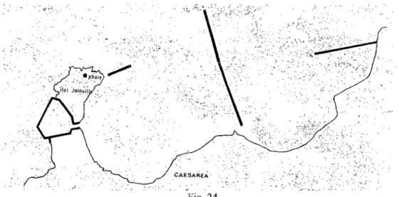
8. Algeria: Cherchel (Iol-Caesarea)
Location: Patron:
Cliff, north on the îlôt Joinville. Unknown
Shape: Octagonal
Materia1s: Angles made ofb10cks ofmasonry, walls made ofmortar and
stone (Opus africanum)
State of Preservation: Foundations and a height of 1.40m of the remaining walls.
Fuel: Unknown
Date: 1 st century AD (?C1audian)
Dimensions: Diameter 18m, W. of each side: 2.32m, angles 2.51m.
Sculpture: None
Epigraphy: None
Primary Sources: None
Secondary Sources: Lassus 1958.
Illustration: Figs. 24-26.
The harbour ofCherche1 is situated in North Africa, 75 kilometers from the city of Aigiers. The lighthouse is 10cated on a cliff north of a small island called the îlot Joinville (Fig. 25). The lighthouse was excavated in 1958-1959 when the Direction des Phares et Balises
responsible for the modem lighthouse erected on the îlot Joinville wanted to install a new antenna (Lassus 1959,218). Excavations were conducted, and the base of a Roman lighthouse was
unearthed.
Little is known of the history of the lighthouse. The Emperor Claudius gave Mauretania Caesarea, where Cherchel is located, the status of Provincia (Lassus 1959, 219) in 40 AD, and inscriptions from the necropolis near the harbour state the presence of an imperial classis (Reddé 1986, 246). The construction of the lighthouse might be dated to the 1 st century AD (Lassus
1959, 219). According to Reddé, the ancient harbour works at Cherchel might have been this military one established by Claudius (Reddé 1986, 246).
The lighthouse seems to have been octagonal (Fig. 26). The northem part is weIl preserved, while its southem part is largely damaged. The angles at the sides of the lighthouse walls measure 2,5m, exterior, on each si de, and 1,85m on the interior, (Lassus 1959,221). The wall thickness is 1,62m. The height of the walls above is 1,40m (Lassus 1959,221). The walls of the octagon, between the angles, have a length of 2,32m and a thickness of 1 ,23m which means that they recede 20cm from the inside. The diameter of the base of the lighthouse is 18m (Lassus 1959,221).
The base ofthe lighthouse rests on a shield of rocks produced by a foundation trench in the bedrock. In this were laid courses or large blocks ofmasonry in an east-west direction (Fig. 27). The masonry is so accurate that the joints between each stone are almost obliterated. Above these, two courses oflarge dressed stones form the angles of the octagon. Above these eight angles were placed masonry blocks carved out of a single picce of stone. The walls between the angle stones were erected in rubble and mortar. This type of construction is known as opus
africanum. The northem wall shows imprints of vertical and horizontal wood planks, part ofthe
original coffering used when the mortar was poured (Lassus 1958,221-2)12.
There is no available evidence for the kind of fuel and the lighting system used for this lighthouse.
Several statues have been found in the area of the lighthouse: one believed to represent Juno-Caelestis (Lassus 1958,224); and a statue of Minerva with snakes (Lassus 1958,224).
12 Lassus, the director of the excavation, does not offer information as to what kind of stones were used for the
Neither ofthese can be securely associated with the lighthouse. No epigraphic evidence was found.
As at the lighthouse at Boulogne-sur-mer (Cat.3), the lighthouse at Cherchel is not located within the harbour installations but rather is isolated. It stands with its back to the harbour on the northem tip near a cliff on the îlot Joinville (Reddé 1986, 245). The cliffis constantly buffeted by strong winds and waves and appears to have eroded over time; sorne ofthe other buildings near the lighthouse have collapsed into the sea. The base of the lighthouse is still in situ. In front of it are the ruins of an apsidal building, which survives only in its base and part of a semi-circular wall of 4.40 m in diameter (Lassus 1959,219). According to Lassus, this structure might have been part of a sanctuary (1959, 219). The remains of the lighthouse show that it was constructed to take into account the walls ofthis apsidal building. The base of the lighthouse is cut in its middle by another much larger polygonal structure, which scholars believe to have been Turkish fortifications (Lassus 1959, 219). The southem part of the ancient lighthouse base was damaged by the erection of the modem lighthouse.
9. Libya: Leptis (Lepcis) Magna
Location: On a mole at the entrance of the harbour.
Patron: Septimus Severus
Shape: Square
Materials: Mortar and rubble with brown limestone facing.
State of Preservation: Platform, southern vaults and parts ofnorthern vaults and part of a Fuel: Date: Dimensions: Sculpture: Epi graph y: Primary Sources: Secondary Sources: Illustration:
comice belonging to 3rd leveL Unknown 3rd century AD (Severan) W 21.2m, Sides 9m. None None None Bartoccini, Zanelli 1960. Figs. 24-26.
The town of Leptis Magna is situated on the Libyan coast 120 kilometer east of Tripoli (Sti11well, Princeton Encyclopedia of Class ica 1 Sites 1976,499), and takes its name from the three main cities (treis poleis). The harbour is located north east ofthe city, and the lighthouse is erected on the northernmost tip of the harbour on the west mole, at the mouth of the Wadi Lebda (Floriani 1966, 1).
The harbour, Punic in origin, is believed to have been reconstructed by the Emperor Septimius Severus during the third century AD as part ofhis building pro gram (Ward- Perkins 1948,59). Septimius Severus was born in Leptis Magna from a good provincial family: his grand-father had been part of one of the first pair of duoviri, and his uncles had both been consuls (Ward-Perkins 1948,59-60). He therefore provided the city with many favours, among which was the building of a lavish harbour with a lighthouse. It is believed that the massive building pro gram was too much for the city' s financial resources and that this led to the dec1ine of Leptis-Magna (Ward-Perkins, 1948,59-60). There is no evidence for the chronology of this lighthouse.
The lighthouse at Leptis Magna was erected on a square platform and displayed two receding levels above. According to a reconstruction by Bartoccini (Hauschild 1976, 248), the platform was accessed by a stairway and entered a large room separated by two long vaults. Two diametrically opposed staircases led to the upper levels; the second and third levels were crowned with large comices (Hauschild 1976, 248).
The excavated platform measured 21.2m (Hauschild 1976, 248). The northem vaults were damaged, but the southem vaults are preserved and spanned 2.43m with a height of 6.20m (Hauschild 1976,248). The inner core ofthe first level measured 9 m (Hauschild 1976,248). Part of the comice originally located on the third level has been excavated, and the height of the lighthouse can be estimated to have been between 30 to 35m (Hauschild 1976,248).
The inner core of the first level was made of opus quadratum and measured 9m. (Hauschild 1976,248) The masonry of the lighthouse seems to have been made of the brown lime stone indigenous to the region and quarried nearby at Ras-el-Hammam (Ward-Perkins 1948, 59).
No statues or inscriptions have been connected to this lighthouse. There are no evidence as to the kind of fuel or lighting apparatus used for the lighthouse at Leptis Magna.
Its location, at the very end of the northem mole, suggests that this lighthouse was used to indicate the entrance to the harbour. The coast here is qui.te fiat and there are no references to inhospitable geological fonnations, such as c1iffs. The area also do es not appear prone to silting and therefore the formation of shoals. The type of lighthouse appears to be a guide to the mouth of the harbour.
10. Egypt: Pharos
Location: On a mole at the entrance of the harbour.
Patron: Ptolemy II (Philadelphus)
Shape: Square
Materials: White granit and pink quartz.
State of Preservation: None
Fuel: Unknown Date: 297 -293 BC Dimensions: Sculpture: Epigraphy: Primary Sources: Secondary Sources: Illustration: W 30m, Sides 12m.
Statues ofPtolemy 1 & II with their consorts and various other statues.
Dedicatory inscription by builder, Sostratos of Cnidos. J osephus, Pliny the EIder.
Thiersh 1909 and Empereur 1998. Figs.29-35.
The island of Pharos is located to the east of Alexandria in the Nile Delta. The mainland forms a bay with two elevated cliffs at each end. The island of Pharos is placed between these two cliffs and therefore offers the possibility of a harbour with two entrances. When the harbour was established, one of these entrances was blocked by a man-made passage, called the
Heptastadio, that connected the island to the mainland (Fig. 29). Moles were set up to the east of
the island, and the lighthouse was erected upon the north-east mole where the fort of Qaitbay is located today (Empereur 1996, 12) (Fig. 30).
Scholars agree that the construction ofthe lighthouse might have started around 297 BC under king Ptolemy 1 Soter and ended in 283 BC during the reign ofPtolemy Il Philadelphus (Empereur 1998, 16). A lighthouse was much needed in this area due to the rocky coast and it also became part ofthe building programs ofboth Ptolemy 1 and Ptolemy Il. The lighthouse proved to be impressive and size and beauty and displayed multiple statues of the kings Ptolemy l and II with their wives, Berenice and Arsinoë, who would have confinned the glory of the
Hellenistic monarchs to all who sailed into port. The project cost 800 talents (Pliny the EIder XXXVI-18) and the job was given to Sostratos of Cnidos, who is believed to have been a friend of King Ptolemy 1 (Empereur 1996, 16). The lighthouse remained in use for nearly 16 centuries Empereur 1998,44-45). Its slow dec1ine started in the 12th century when it was transforrned into a mosque (Empereur 1998, 45). It stood until the 13 th century when, according to an Arab traveler
called Edrisi, it was destroyed by an earthquake (Empereur 1998, 88-89).
There is sufficient iconographic evidence as well as written sources to aid in the reconstruction of the lighthouse at Pharos. According to the texts by Edrisi, the lighthouse was erected on a square base (Fig. 31). Tt was buiIt in three levels and was accessed by an entrance measuring Il.50m by 4.90m; it had a depth of 2.1. The first of these levels was square with a slightly pyramidal shape and had a height of approximately 71 m by a width at the base of 30m (Empereur 1998, 26). Approximately fi ft y rooms were set within the first level for storage of fuel as well as staff quarters (Empereur 1998, 26-27). Daylight carne into the tower by several
windows (Empereur 1998, 26). Large ramps provided a means of ascension into the tower, which, according to Edrisi, (Thiersch 1909,44) were wide enough for two horses since animaIs, mostly donkeys and mules, were used to carry the fuel to the top. On the top of this first level was a comice 2,30 m high displaying statues of Tritons blowing into conch shells (Fig. 32). These Tritons were located on each of the tower's four corners.
The second level was octagonal and measured 34m in height. The top of this level was reached by an interior stairway ofthirty-two steps (Fig. 32). The third level was circular and measured 9m in height; it had had an eighteen-step indoor stairway. A cupola at the top of the
lighthouse held the beacon. The total height of the lighthouse is estimated to have been 130 m (Empereur 1998,24).
Numismatic (Fig. 34) and archaeological evidence (Empereur 1998, 102) suggests that statues a1so decorated the monumental entrance (Fig. 35). This large entrance consisted oflinte1 and j ambs made of pink quartz closed by enormous doors. The lintel and jambs have been excavated but the doors are still missing (Empereur 1998, 102-103). There seems to have been a group ofnine statues (Fig. 35) placed on either side of the door of the monumental entrance. The largest probably represented Ptolemy l and Bernice (Empereur 1998, 102).
Archaeological evidence confirms that the lighthouse at Pharos was built with the white granite stone indigenous to the region (Empereur 1998, 22-23 ) and quarried on the north coast of Egypt. The blocks were joined together with metal clamps. The solid parts of the structure, such as lintels, were fashioned from Assouan granite, while sorne the architectural features were of pink quartz.
Ancient texts do not help to understand the lighting and fuel of this lighthouse, but the text by Edrisi is more illuminating (Empereur 1996, 124-127, Thiersch 1909,44). He states that the fuel was carried upstairs along a ramp by means of animaIs; this implies a large amount of fuel, although the stairs at the top of the second floor are hardly fit for a work animal. It may be that fuel was carried and stored near the second floor throughout the day for the night beacon and that necessary quantities were hauled by hand as needed to stoke the fire.
An inscription made of attached letters of lead was placed on one of the outward face of the lighthouse (its exact location still unclear) and provided the name of the
builder: "Sostratos son of Dexiphanes of Cnidos dedicates this monument to the savior gods for the protection ofsailors"(Empereur 1998,16, Thiersch 1909, 44).The lighthouse is thus
dedicated to the Savior Gods, who, until recently, were thought to be Castor and Pollux, the . Dioscuri who helped protect sailors (Howatson 1989, 322-323). Recent evidence, however, has
changed this hypothesis: according to Empereur (1998, 16), Ptolemy land his wife Berenice are referred to as the Savior Gods and the lighthouse may have been dedicated to those who
commissioned it.
Iconographic and archaeological evidence has proven that many statues were erected on top and around the lighthouse. Coins representing the lighthouse at Pharos show a solitary statue on top of the cupola (Fig. 34), probably Poseidon, along with the tritons on each corner of the first leve1. The Begram Vase, an ancient glass vessel, found in 1937, also depicts the lighthouse of Pharos. (Fig. 33) This vase, made of carved glass, shows the upper levels of the Pharos
lighthouse with its masonry and windows. Parts ofthe second level are also visible on the left of the vase and show the tritons on either side below the top level. On top is the cupola, where a youthful statue holding a paddle stands in heroic nudity. The iconography ofthis statue is inconsistent with most representations ofPoseidon, as the latter is most often shown as an older man with a beard. Goodchild argues convincingly that the statue might represent Zeus Soter, the savior (Goodchild 1961,218-223). Consensus now appears to point to the fact that the statue on top ofthe lighthouse might have represented Ptolemy l Soter in Heroic nudity.
A text of 670 AD by Aroulfe (Empereur 1998, 35) mentions that torches were used to light piles ofwood in the Pharos. Torches were often dipped in a petroliferous substance. In Mesopotamia, bitumen and other fossi! fuel were harvested from swamps and used on torches
(Mayor 1997, 56 ), and the torches and wood used to light the lighthouse of Pharos could have been treated with a petroleum by-product. Pliny the EIder also mentions that the light of the beacon could be seen from very far and shone like a star (Pliny the EIder, XXXVI.18). A simple wood fire does not maintain a steady-enough light for this description, even when constantly stoked.
The earthquake of the 13th c. completely submerged the remains of the Pharos. It is believed that the violence ofthe earthquake spread the blocks, statues, and other structural
elements over a surface of 1.3 hectares (Empereur 1998, 96-103). Artistic renderings confinn that the lighthouse was located at the entrance of the harbour, and it would therefore have indicated the entrance ofthe harbour, but this may not have been its sole function. Epigraphic evidence suggests that the coast surrounding Pharos was inhospitable (Pliny the EIder, XXXVI.18), and it may be that the lighthouse also served also as a warning signal. This hypothesis is further
strengthened by Josephus (Jewish Wars, IV, 612), who mentions that ships seeing the light of Pharos at night would drop anchor and wait until daylight to resume sailing, as the coast was so dangerous.
The lighthouse of Pharos is without a doubt the best documented ancient lighthouses. Its construction during the Hellenistic era set the new standard for future lighthouses such as the lighthouse at Ostla (Cat. 6), which seems to follow sorne of its guidelines by using decreasing levels or the lighthouses of Boulogne-sur-Mer (Cat. 3) and Dover's Eastern Pharos (Cat. 1) which uses the aerodynamic octagonal shape, to name but a few.
discussed individually in the previous chapter. Through comparative study, a tentative morpho10gical typo10gy/c1assification oflighthouse will be proposed.
Distribution
Chart 1: Distribution
Number of Cylindrical/Round Square Hexagonal Octagonal
Country Lighthouses
Africa 3 Cats. 9-10 Cat.8
Europe 6 Cat.5 Cats. 6-7 Cats. 2-4 Cats.1-3
The distribution oflighthouses' archaeological remains indicates that Europe possessed almost twice as many lighthouses as Africa. Many factors influence the state of preservation of these remains. The length of time that a lighthouse was kept in service could affect its
preservation. For instance, the lighthouse at Boulogne-sur-Mer (Cat. 3) was in use until the 1
i
h c.; the lighthouse at La Coruna (Cat. 7) is still in service; and Pharos was used as a mosque till its destruction in the 13 th c. This suggests that Europe kept more of its lighthouses in service thanAfrica.
Tsunamis and earthquakes might also be responsible for the disappearance oflighthouses along the African coast. One example, cited above, is Pharos (Cat. 10), which was destroyed by such an earthquake.
The need for these lighthouses may vary from one continent to another. Dangerous coasts might require lighthouses, such as Dover (Cats.1- 2), Boulogne-sur-Mer (Cat. 3), Ostia (Cat. 6), Cherchel (Cat. 8) and Pharos (Cat. 10). This suggests that the number of dangerous coasts were
perceived to be greater in Europe than Africa, and this belief might have influenced the decision to erect a lighthouse.
Small beacons, such as the 6th c. lighthouse at Thasos (Fig. 23; Empereur, Archontidou-Argyri,Simossi 1989, 51-59), might have dotted the coast lines, thus rendering obsolete the need for larger lighthouses. The limited archaeological evidence for these small structures might be due to the re-use of their building materials once they were no longer in service (Empereur, Archontidou-Argyri,Simossi 1989, 51-59). Theirlocation, often on top of c1iffs could render them vulnerable to earthquakes or tsunamis.
The number of inland harbours might also be a reason to erect a lighthouse. Harbours such as Frejus contained two lighthouses: Lanterne d'Auguste (Cat. 4) and Butte Saint-Antoine (Cat. 5). The harbour of Mer, also inland, shows one lighthouse: Boulogne-sur-Mer (Cal. 3). None of the lighthouses in Africa offers protection to an inland harbour.
The patterns displayed in Chart 1 suggest that geographic dispersion does not affect the architectural shape oflighthouses. Square and octagonallighthouse plans are found in Europe, at Dover (Cats. 1-2), Boulogne-sur Mer (Cat. 3), Ostia (CaL 6), and La Coruna (CaL 7), as weIl as in Africa, at Cherchel (Cat. 8), Leptis Magna (Cat. 9), and Pharos (Cal. 10). The detenninant factor for the plan of a lighthouse was not its geographic location.
Distribution within Site
CHART II - Distribution Within Site.
Plan Cliffs Harbour installations Canals
Square 1 3
Octagona1 3
Hexagonal 1 1
CylindricallRound 1
Chart II shows that the location of lighthouses within each site seems to affects the architectural shape ofits plan. Patterns can be seen with the square and octagonal examples. Square lighthouses predominate when located within harbour installations. This may be due to many factors: these lighthouses are often erected at the end ofbreakwaters on man made-moles. Man-made moles are usually built using the Roman technique of sinking a square caisson and filling it with opus caementicium (Hohlfelder 1985, 81). A square platform is the easiest base for these structures, as at Leptis Magna (Cat. 9), Pharos (Cat 10), and at Ostia (Cat. 6) This would leave only one side of the lighthouse, the side facing the sea, exposed to inclement elements. For instance, the excavations at Leptis Magna (Cat. 9) show that the southern side of the lighthouse, which was facing the entrance of the harbour, had been much better protected than the northern side, which was exposed to the elements.
The lighthouses found within harbour constructions are often part of an Emperor' s
building progrmll such as the Emperor Claudius at Ostia (Cat. 6), and Septimus Severus at Leptis Magna (Cat. 9). Both these lighthouses appear to have been built following the prototype of the lighthouse at Pharos (Cat. 10), which served propagandistic as well as practical purposes for