Assessing the geographic resolution of exhaustive
tabulation for geolocating Internet hosts
S.S. Siwpersad1, Bamba Gueye2, and Steve Uhlig1 1 Delft University of Technology, The Netherlands [email protected],[email protected]
2 Universit´e de Li`ege, Belgium [email protected]
Abstract. Geolocation of Internet hosts relies mainly on exhaustive tabulation
techniques. Those techniques consist in building a database, that keeps the map-ping between IP blocks and a geographic location. Relying on a single location for a whole IP block requires using a coarse enough geographic resolution. As this geographic resolution is not made explicit in databases, we try in this paper to better understand it by comparing the location estimates of databases with a well-established active measurements-based geolocation technique.
We show that the geographic resolution of geolocation databases is far coarser than the resolution provided by active measurements for individual IP addresses. Given the lack of information in databases about the expected location error within each IP block, one cannot have much confidence in the accuracy of their lo-cation estimates. Geololo-cation databases should either provide information about the expected accuracy of the location estimates within each block, or reveal infor-mation about how their location estimates have been built, unless databases have to be trusted blindly.
Keywords: geolocation, exhaustive tabulation, active measurements
1
Introduction
Location-aware applications have recently become more and more widespread. Exam-ples of such applications comprise targeted advertising on web pages, displaying local events and regional weather, automatic selection of a language to first display content, restricted content delivery following regional policies, and authorization of transactions only when performed from pre-established locations. Each application may have a dif-ferent requirement on the resolution of the location estimation. Nevertheless, as IP ad-dresses are in general allocated in an arbitrary fashion, there is no strict relationship between an IP address and the physical location of the corresponding physical inter-face.
Database-driven geolocation usually consists of a database-engine (e.g. SQL/MySQL) containing records for a range of IP addresses, which are called blocks or prefixes. When coupled with a script embedded in a website and upon a client access to the web-site being detected, a request can be sent instantly to the database. This request can be to check if the IP address has an exact or longest prefix match (LPM) with a corresponding geographic location and coordinate. Since there is no actual measurement involved but
merely a simple lookup, the request can be served in a matter of milliseconds. The ex-pected time for which a website should be fully loaded, without causing any nuisance, is in general within one second. Most commercial database providers offer highly op-timized scripts as well as abundantly documented application programming interfaces, which meet this short expected response time. The database-driven geolocation thus seems to be a useful approach.
Examples of geolocation databases are GeoURL [1], the Net World Map project [2], and free [3] or commercial tools [4–9]. Exhaustive tabulation is difficult to manage and to keep updated, and the accuracy of the locations is unclear. In practice however, most location-aware applications seem to get a sufficiently good geographic resolution for their purposes.
In this paper, we try to better understand the resolution of geolocation databases, by comparing their location estimates with a well-known active measurements-based geolocation technique, CBG [10]. We show that, as expected, the geographic resolution of databases is far coarser than the resolution provided by active measurements, typi-cally several times coarser than the confidence given by active measurements. As most geolocation databases do not give confidence in the accuracy of their location records, they are likely not to be trustworthy sources of geolocation information if precise IP address-level locations are required. Applications that require as much accuracy as pos-sible would thus typically have to rely on active measurements, not databases. To im-prove the quality of current geolocation databases, we believe that the database records should contain information about the expected confidence in the location estimates.
The remainder of the paper is structured as follows. Section 2 introduces the datasets used. Section 3 studies the geographic resolution of databases. Section 4 describes our active measurements for geolocating Internet hosts. In Section 5, we compare the reso-lution of active measurements with location estimates from databases. Finally, we con-clude in Section 6.
2
Datasets
During the past few years, a growing number of companies have spent a lot of effort in creating databases for geolocation purposes. Most of these companies, like Max-mind [11], Hexasoft [8] and Quova [9], provide commercially available databases with periodic updates. There are also freely available databases such as Host IP [3].
One of the problems of geolocation databases is that typically one does not know much about the methodology used by the database provider to gather their geographic information. One has to blindly rely on the claimed geographic resolution they provide. There are four basic geographic resolution levels that occur in most databases: zipcode, city, country and continent. Note that some databases may use more resolutions than those four, like regions that may relate to countries, continents, or some intermediate resolution. In most instances, we expect that the zipcode and the city granularity will be very similar. The country resolution is widely recognized to be the typical one that is re-liable from databases. Many databases do not give any information about the expected geographic resolution of the database records, and when they do, not all records do contain this information. The price of commercial databases increases with improved
geographic resolution, or with additional information about attributes of IP blocks like ISP, connection type of hosts, and in a single instance confidence about the location es-timates. Note that we know one example of geolocation database that provides a notion of confidence related to the uncertainty about where the end-user actually lies compared to the location estimate [9]. This notion of confidence is however not quantitative, i.e. it does not express how far an IP address belonging to the IP block is expected to be from the location estimate provided, rather the type of host or connection that the host is using.
In the sequel of this paper, we restrict our attention to two databases. These com-mercial databases, GeoIP by Maxmind [11] and IP2Location by Hexasoft [8], are used because of their popularity (see [8, 11] for a listing of some of their customers) and their expected reliability. The number of IP blocks and the coverage in IP addresses of
Database P ublic blocks Special blocks T otal blocks P ublic addresses T otal addresses
Maxmind 3,278,391 2 3,278,393 2,322,257,277 2,355,811,965 Hexasoft 5,111,309 44 5,111,353 3,991,797,760 4,294,967,296
Table 1. Overview of the 2 selected databases.
the two databases is shown in Table 1. Maxmind contains more than3 million blocks,
and Hexasoft more than5 million blocks. Note that a few blocks, called special blocks
according to RFC3330 [12], should not be considered.
3
Geographic resolution of databases
Based on the information provided in the geolocation databases, it is hard to say any-thing about the actual geographic resolution of the location estimates. We merely know that most records contain either a city or a country name.73.1% of the databases records
in Maxmind contain a city name (66.6% for Hexasoft), then if no city name can be
found,3.4% of the records contain a country name (33.2% for Hexasoft). When
nei-ther a city name nor a country name is present in the record, a continent name or a federation of countries will typically be found. Note that sometimes records contain ge-ographic coordinates only. While the area of countries and continents are well-defined, the area of a city depends much on what is meant by the boundaries of the considered city. For example, taking the largest250 cities in the world3shows well how much the area of a city can vary, especially depending on whether the suburbs or the ”metro” area are considered to be part of the city or not.
When we analyze the number of unique cities in both Maxmind and Hexasoft, we obtain110, 349 unique cities in Maxmind and 15, 133 in Hexasoft. 100, 087 cities in
Maxmind occur each in a single IP block (12, 918 for Hexasoft), and 10, 262 cities
occur each in multiple IP blocks (2, 215 in Hexasoft). When several IP blocks have
3http://www.citymayors.com/statistics/largest-cities-area-250. html
the same city information, they will have the same location estimate in the database. Note that a city is defined by a city name, but also a country and a continent when this information is available in the databases. Some city names occur in several countries and/or continents. When we compare the occurrence of unique city names (string-wise), we observe that among a total of 7, 844 unique city names present in the databases, 7, 618 are present in one database only, and 226 are in both.
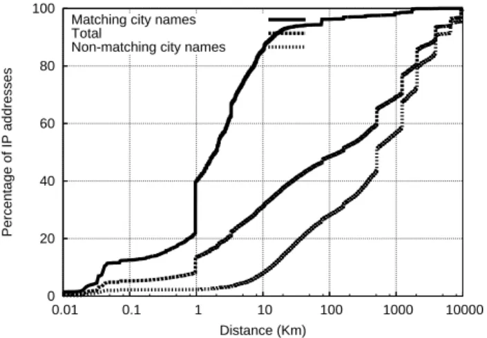
0 20 40 60 80 100 0.01 0.1 1 10 100 1000 10000 Percentage of IP addresses Distance (Km) Matching city names
Total
Non-matching city names
Fig. 1. Difference in location between Maxmind and Hexasoft.
In geolocation databases, a unique location is associated to a given city. It is thus im-possible to infer directly the geographic resolution used by the databases by comparing the location estimates of different IP blocks for a given city. However, we can compare the location estimates from Maxmind and Hexasoft, hoping that the difference between their location estimates will give us an indication of their geographic resolution. We rely on a free database, Host IP [3], that contains1, 356, 506 IP blocks, to perform lookups
in the two other databases. For each IP block of Host IP, we take an IP address and use it to lookup the two databases. We then compute the difference between the two loca-tion estimates returned by the databases. Figure 1 displays the cumulative distribuloca-tion of the distance between the locations given by the two databases when performing a lookup on IP addresses from the Host IP database. We provide three different curves, one for the distribution of the distance when the city strings match between Maxmind and Hexasoft, when they do not match, and irrespective of the city-level match. Among the1, 264, 892 IP addresses looked up, 377, 736 have the same city-level name in the
databases, while887, 156 do not have matching city names. We see on the curve that
corresponds to matching cities that the difference in location between the databases tends to be far smaller than when the city names do not match. Depending on whether the city names match between the two databases entries, the typical distance between their location estimates differs much. When the IP blocks from the two databases have the same city name information, their locations are very close, typically less than10Km.
When the city names do not match on the other hand, the locations differ more than usual. Globally, about50% of the IP lookups give a difference smaller than 100Km. If
the differences observed between the databases were to reflect in some way differences in geographic resolutions used by them, then we would deduce that those resolutions go from1Km up to thousands of Km.
4
Measurements-based geolocation
Given that we cannot obtain the actual geographic location of many IP addresses in the Internet, we need to rely on location estimates. To obtain location estimates for a large enough number of IP hosts, we need accurate location estimates. For this, we rely on active measurements. Active measurements have the advantage of providing an explicit estimate of their accuracy.
Previous works on measurement-based geolocation of Internet hosts [13,14] use the positions of reference hosts, called landmarks, with a well-known geographic location as the possible location estimates for the target host. This leads to a discrete space of an-swers; the number of answers is equal to the number of reference hosts, which can limit the accuracy of the resulting location estimation. This is because the closest reference host may still be far from the target. To overcome this limitation, the authors of [10] pro-pose the Constraint-Based Geolocation (CBG) approach, which infers the geographic location of Internet hosts using multilateration. Multilateration refers to the process of estimating a position using a sufficient number of distances to some fixed points. As a result, multilateration establishes a continuous space of answers instead of a discrete one. This multilateration with distance constraints provides an overestimation of the distance from each landmark to the target host to be located, thus determining a region, i.e. confidence region, that hopefully encloses the location of the target hosts [10]. For instance, the confidence region allows a location-aware application to assess whether the estimate is sufficiently accurate for its needs.
Although showing relatively accurate results in most cases, these measurement-based approaches may have their accuracy disturbed by many sources of distortion that affect delay measurements. For example, delay distortion may be introduced by the cir-cuitous Internet paths that tend to unnecessarily inflate the end-to-end delay [15–17] and by the potential existence of bottleneck links along the paths. To deal with these sources of distortion, GeoBuD, Octant, and TBG were proposed by [18–20]. The GeoBuD tech-nique shows that estimating buffering delays, by traceroute measurements, at interme-diate hops along the traceroute path between a landmarks and a target host enables to improve the accuracy of geolocation of Internet hosts. In the same way, Topology-Based Geolocation (TBG) and Octant which are an extension of multilateration tech-niques with topology information were proposed. TBG additionally uses inter-router latencies on the landmark to target network paths to find a physical placement of the routers and target that minimizes inconsistencies with the network latencies. TBG relies on a global optimization that minimizes average position error for the routers and target. Octant differs from TBG by providing a geometric solution technique rather than one based on global optimization. Although it considers intermediate routers as additional landmarks, Octant also uses geographic and demographic information. Geographic and
demographic constraints are used in Octant to reduce the region size where the target may be located. Only landmasses and areas with non-zero population are considered as possible target locations [19]. Furthermore, it takes into account queuing delays by using height as an extra dimension. It requires significantly computational time and re-sources. All these techniques generate a huge amount of overhead in the network for a small gain in accuracy.
To illustrate the marginal improvement of complex measurement-based geolocation techniques, we do not only consider CBG, but also add to it estimation of the bottle-neck bandwidth on the path. The bottlebottle-neck bandwidth can be defined as the maximum throughput that is ideally obtained across the slowest link over a network path. CBG with bandwidth estimation allows the improvement of the geolocation estimation given by CBG. Additional delay distortions caused by the bottleneck along the path are re-moved from the overestimations of distance constraints that define the region enclosing the target host in CBG, allowing tighter overestimations that result in a smaller region. Smaller regions that still enclose the target host provide a more accurate location esti-mation.
4.1 CBG with bandwidth estimation
To estimate the bottleneck bandwidth over a network path between each landmark and a given target host, we use SProbe [21]. SProbe estimates bottleneck bandwidth in un-cooperative environments, i.e. a measurement software is only deployed locally on the measurement host. SProbe relies on the exploitation of the TCP protocol. It sends two SYN packets to an inactive port on the remote host to which it appends1460 bytes of
data. Since the port is inactive, the remote host answers to these packets with two RST packets of40 bytes each. For the native traceroute used by Octant, TBG, and GeoBuD,
three packets are sent to each intermediate hops between a source and a destination causing an important overhead. SProbe produces accurate and fast estimates using little amount of probing data, so that it can scale to a large number of estimates.
For our evaluation, we rely on39 PlanetLab nodes [22] as landmarks and we use
a subset of the two commercial databases (Maxmind and Hexasoft) as input for hosts to be localized. Each landmark estimates the bottleneck bandwidth towards a given target host by sending7 SYN packets. We found in Section 3 that there are 226 city
names that are unique and can be found in both databases. Using these city names we find41, 797 IP blocks from Maxmind matching those city names. Since we need
”pingable” addresses within each IP block to be used in measurements, we use the single ping approach to find at least one IP address per block. The single ping approach consists in brute-force probing all IPs within a prefix, and stopping the probing within the prefix as soon as a single IP address has answered. We find18, 805 IP blocks which
have at least one pingable IP address for Maxmind. For the Hexasoft database, we have41, 758 IP blocks among which 15, 823 contain at least one pingable IP address.
Using the set of pingable addresses, Figure 2 presents the cumulative distribution of the confidence region in km2for location estimates in both the Maxmind and Hexasoft databases. Figure 2(a) shows that CBG with bandwidth estimation assigns a confidence region with a total less than104km2for about20% of the location estimates, whereas the basic CBG has only10% for the same confidence region. For IP addresses that
0 0.1 0.2 0.3 0.4 0.5 0.6 0.7 0.8 0.9 1 1 2 3 4 5 6 7 8 Cumulative probability Area log10(km2) CBG with bandwidth estimation
Basic CBG
(a) CBG using the Maxmind dataset
0 0.1 0.2 0.3 0.4 0.5 0.6 0.7 0.8 0.9 1 1 2 3 4 5 6 7 8 Cumulative probability Area log10(km2) CBG with bandwidth estimation
Basic CBG
(b) CBG using the Hexasoft dataset
Fig. 2. Confidence region.
are given a confidence region between104km2and106km2, bandwidth estimation is less and and less useful. Finally, when the confidence region is larger than 106km2, bandwidth estimation is useless, or even makes the confidence region larger than the classical CBG technique.
Measurement-based geolocation techniques assume that the target host is able to answer measurements. Active measurements will be impractical when we rely on ICMP echo probes for instance, which can be filtered by a firewall. We observe that for most IP blocks, we get only a few IP addresses that answer our probes, typically only one.
5
Comparison between databases and active measurements
Having discussed the geographic resolution of geolocation databases in Section 3 and presented the confidence area obtained with active measurements in Section 4, we use the active measurements introduced in Section 4 to check the resolution of geolocation databases. When comparing geolocation based on active measurements and databases, several situations may occur. One possibility is when databases and active measure-ments give the same location for an IP address, i.e. databases give a location that lies within the confidence region given by active measurements. This situation is not typi-cal, given the coarse geographic resolution of database records. When location estimates from the databases do not belong to the confidence region provided by active measure-ments, we would tend to doubt the accuracy of databases rather than expecting that the confidence region suffers from measurements biases, as the confidence region is made from higher bounds on the distance constraints.
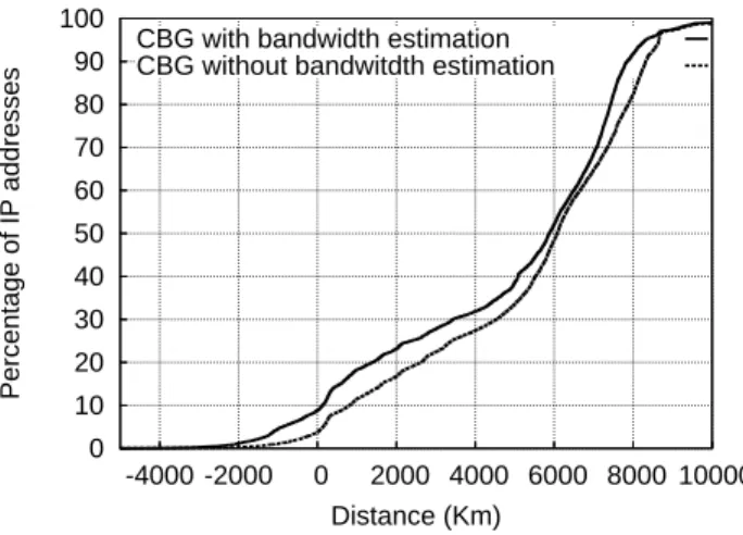
Let us now measure the distance between the border of the confidence region given by CBG and the location estimates of the databases. If CBG is correct in its estimation of the location, then this distance should provide a lower bound on the actual geolo-cation error made by the database. Figure 3 shows the cumulative distribution of the minimal distance between the location estimates of the Maxmind dataset (results for Hexasoft are similar) and the border of the confidence region given by CBG, with and without using bandwidth estimation. This minimal distance first tells whether the loca-tion estimates from databases are within the confidence region or not. If the distance
0 10 20 30 40 50 60 70 80 90 100 -4000 -2000 0 2000 4000 6000 8000 10000 Percentage of IP addresses Distance (Km) CBG with bandwidth estimation CBG without bandwitdth estimation
Fig. 3. Distance between the database results and the border of the CBG confidence region
(Max-mind dataset).
is negative on Figure 3, it means that databases are within the confidence region. If the confidence region is small and the location estimate of the database lies within the confidence region, then we expect that it is likely that the database estimate is correct. We observe on Figure 3 that more than90% of the probed IP addresses have a database
location estimate that lies outside the confidence region, and quite far away from it. Note that in a few cases the distance on Figure 3 is negative and large, meaning that the confidence region is pretty large.
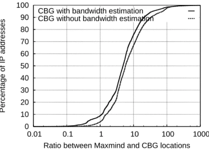
The large distances shown in Figure 3 suggest that the geographic resolution of databases is poor, compared to the confidence region given by CBG. To quantify the rel-ative resolution of databases compared to the confidence region given by CBG, we plot in Figure 4 the ratio of the difference between the CBG estimate and the locations given by the Maxmind dataset (results for Hexasoft are similar), divided by the uncertainty in the CBG estimate (radius of the confidence region). Let us denote the location given by CBG by loccbg(IP ), the radius of CBG’s confidence region by radiuscbg(IP ), and the location given by a database by locdatabase(IP ), then the ratio we compute is| locdatabase(IP )−loccbg(IP )
radiuscbg(IP ) |. A ratio smaller than 1 means that the location estimate
given by the database is within the confidence region. In this case, we would tend to trust the location estimate given by the database. A ratio larger than1 means that the
location estimate given by the database lies outside the confidence region. In that case, it is likely that the geographic resolution of the database is too coarse to give an accurate location estimate for the considered IP address. We observe on Figure 4 that the ratio is typically far larger than1, meaning that the geographic resolution of the databases
compared to the confidence in the active measurements estimates is poor, relative to the confidence region of CBG. For only less than10% of the probed IP addresses, the
databases have a good enough geographic resolution to make them comparable to the accuracy of active measurements. Note that those results do not suggest that location
0 10 20 30 40 50 60 70 80 90 100 0.01 0.1 1 10 100 1000 Percentage of IP addresses
Ratio between Maxmind and CBG locations CBG with bandwidth estimation
CBG without bandwidth estimation
Fig. 4. Ratio of the distance of the databases to the distance of CBG with respect to the CBG
location estimate (Maxmind dataset).
estimates provided by databases are incorrect, but rather that the geographic resolution at which databases give mappings from IP blocks to locations are too coarse to provide accuracy at the level of individual IP addresses.
6
Conclusion
In this paper, we assessed the geographic resolution of geolocation databases. We de-scribed the typical content of such databases, showing that they do not contain informa-tion to give confidence in the expected accuracy of their locainforma-tion estimates. We illus-trated the relative coarse resolution databases provide, by showing how large the span of cities is, and how much the location estimates differ between the considered databases. We carried out active measurements in order to compare the geographic resolution of databases to a more accurate standard. We quantified the accuracy of active measure-ments, and tried to improve them by adding bandwidth measurements to reduce the bias from bottleneck links.
Our comparison of the active measurements and the location estimates from the databases demonstrated the coarse geographic resolution of databases location esti-mates. We showed that not only the distance between the location estimate of the databases and the location given by active measurements is very large, but that also difference between the database location estimates from the active measurements esti-mates, divided by the accuracy expected from the active measurements, is very large.
Our work shows that the geographic resolution of geolocation databases is coarse compared to the one of active measurements. That does not mean that the location es-timates given by databases are not good enough. Information about the geographic res-olution of the databases can be embedded in them, for example by giving an estimate of the city-level span for each record. In general, we do not expect that active
measure-ments will be so helpful to improve the geographic resolution of geolocation databases, simply because databases work at the level of IP blocks. However, in particular cases where better accuracy is required for specific IP addresses, active measurements have great potential to provide better location estimates than databases.
Acknowledgments
Bamba Gueye is supported by the IST ANA project.
References
1. GeoURL,http://www.geourl.org/.
2. Net World Map,http://www.networldmap.com/. 3. Host ip,http://www.hostip.info.
4. Digital Island Inc,http://www.digitalisland.com/. 5. Akamai Inc,http://www.akalai.com/.
6. GeoNetMap,http://www.geobytes.com/GeoNetMap.htm. 7. WhereIsIP,http://www.jufsoft.com/whereisip/.
8. H. D; S; Bhd, Ip2location LLC,http://www.ip2location.com. 9. GeoPoint,http://www.quova.com/.
10. B. Gueye, A. Ziviani, M. Crovella, and S. Fdida, “Constraint-based geolocation of internet hosts,” IEEE/ACM Trans. Netw., vol. 14, no. 6, pp. 1219–1232, 2006.
11. MaxMind LLC, MaxMind,http://www.maxmind.com.
12. IANA, “Special-use IPv4 addresses,” Tech. Rep., Internet RFC 3330, Sept. 2002, http://www.rfc-editor.org/rfc/rfc3330.txt.
13. A. Ziviani, S. Fdida, J. F. de Rezende, and O. C. M. B. Duarte, “Improving the accuracy of measurement-based geographic location of Internet hosts,” Computer Networks, Elsevier
Science, vol. 47, no. 4, pp. 503–523, Mar. 2005.
14. V. N. Padmanabhan and L. Subramanian, “An investigation of geographic mapping tech-niques for Internet hosts,” in Proc. of ACM SIGCOMM, San Diego, CA, USA, Aug. 2001. 15. H. Tangmunarunkit, R. Govindan, S. Shenker, and D. Estrin, “The impact of routing policy
on internet paths,” in Proc. of IEEE INFOCOM, Anchorage, AK, USA, Apr. 2001. 16. L. Subramanian, V. Padmanabhan, and R. Katz, “Geographic properties of Internet routing,”
in Proc. USENIX, Monterey, CA, USA, June 2002.
17. H. Zheng, E. K. Lua, M. Pias, and T. Griffin, “Internet Routing Policies and Round-Trip-Times,” in in Proc. of PAM Workshop, Boston, MA, USA, Apr. 2005.
18. B. Gueye, S. Uhlig, A. Ziviani, and S. Fdida, “Leveraging buffering delay estimation for geolocation of Internet host,” in Proc. IFIP Networking Conference, Coimbra, Portugal, May 2006, Lecture Notes in Computer Science (LNCS) 3976, pp. 319–330.
19. B. Wong, I. Stoyanov, and E. G¨un Sirer, “Geolocalization on the internet through constraint satisfaction,” in WORLDS’06: Proceedings of the 3rd conference on USENIX Workshop on
Real, Large Distributed Systems, Berkeley, CA, USA, 2006, pp. 1–1, USENIX Association.
20. E. Katz-Bassett, J. P. John, A. Krishnamurthy, D. Wetherall, T. Anderson, and Y. Chawathe, “Towards ip geolocation using delay and topology measurements,” in Proc.
ACM/SIGCOMM IMC measurement, Rio de Janeriro, Brazil, Oct. 2006.
21. S. Saroiu, P. K. Gummadi, and S. D. Gribble, “Sprobe: A fast technique for measuring bottleneck bandwidth in uncooperative environments,” in Proc. of IEEE INFOCOM, New York, NY, USA, June 2002.
22. PlanetLab: An open platform for developing, deploying, and accessing planetary-scale