Learning for resilience
Insights from Cambodia's rural communities
Chapter 6 - Differentiation of swidden agriculture in
Northeast Cambodia: Kavet swiddeners, the state and
the markets in Kok Lak commune
YOU Rithy, Vivien KLEINPETER and Jean-Christophe DIEPART
Suggested citation: You, R., Kleinpeter, V. and Diepart, J.-C. (2015) Differentiation
of swidden agriculture in Northeast Cambodia: Kavet swiddeners, the state and the
markets in Kok Lak commune. in Diepart, J.-C., (ed.) Learning for resilience: Insights
from Cambodia’s rural communities, Phnom Penh: The Learning Institute. pp. 147-175.
The Learning Institute
2015
Sec
ti
on
C
Key words: Swidden agriculture, indigenous people, Kavet, Protected Area management, co-management, land use change, migration
Differentiation of swidden agriculture in
Northeast Cambodia: Kavet swiddeners, the
state and the markets in Kok Lak commune
CHAPTER 6
Until recently, Kavet ethnic minority people traditionally practiced swidden agriculture and accessed natural resources in the uplands as an important, and unchallenged, part of their food system. This present study aims to trace the historical transformation of land use and tenure practices by Kavet communities in Kok Lak commune in the context of various state-driven and social-economic transformations. At commune level, we look at land use changes along with the migrations associated with these transformations. We also aim to understand how these changes have induced social differentiation between households as it relates to their entitlements, their production activities and their income structure.
We examine the transformation in land use prompted by a multiplicity of drivers (demographic, economic, political, institutional and cultural) and in land tenure regimes through a land control matrix that differentiates between two types of rights (the land rights of the users and the rights to manage those rights given to the users). We discovered that the Kavet people have been resilient in protecting and promoting the core of their swidden territories and traditions; however, recent developments (including the establishment of the Virachey National Park (VNP) and market incentives) have considerably fragmented their land uses, cultural values and institutions. Through forced and free migration, some households have adopted new forms of agriculture (e.g. paddy, and annual and perennial non-rice crops) and converted their swidden land into cashew plantations, while others still rely solely on the practice of swidden agriculture as a lifestyle. By reviewing past transformations, by identifying the role swidden agriculture has had and the contribution it has made to the lives of the Kavet people, we recommend that efforts be made to conserve it in recognition of the pivotal role it plays in community development and to adopt better land use planning at local level. But proper consideration should also be given to the Kavet people who do not practice swidden agriculture.
YOU Rithy, Vivien KLEINPETER and Jean-Christophe DIEPART
INTRODUCTION
Swidden agriculture has been a dynamic farming system for centuries in Southeast Asia where it is mainly practiced by ethnic minority groups (Fox et al. 2009). It comprises a temporally and spatially complex form of farming, typically represented in the landscape by a large number of distinct land use features, each of which may be in some kind of transition (Padoch et al. 2007). The capacity of swiddeners to integrate forest use into agricultural production relies on an intimate knowledge of the ecology of natural resources (Condominas 2009, Fox et al. 2008, Ironside and Baird 2003). However, swidden agriculture has not tended to find favor in Southeast Asia, where governments generally associate it with deforestation and degradation of soil and water resources (Ducourtieux 2006, Fox et al. 2009). Throughout history, state-driven projects have tried with varying degrees of success to integrate swiddeners with low-land paddy farmers (Baird 2009, Baird 2010, De Koninck 2006, Scott 2009).
Swidden systems have always been in flux but for the past 40 years the increased pace has resulted in transformations that have exerted profound and irreversible effects on the everyday lives of swiddeners (Fox et al. 2009, Fox et al. 2008). Swidden land has been replaced by protected forest (Ducourtieux et al. 2005, Fox et al. 2009) and extensive agriculture systems including annual and perennial crops, tree plantations, horticultural plants and livestock grazing (Schmidt-Vogt et al. 2009). These transformations have followed multiple pathways but are usually driven by a synergy between political-economic decisions at central state level (i.e. land reform, Protected Areas management, the granting of large-scale land concessions, and resettlement politics) and the social-economic contingency at the local level (i.e. cash crops, wage labor opportunities, niche markets, incidence of migration and new rural-urban relationships) (Fox et al. 2009).
In Cambodia, swidden agriculture is traditionally practiced by indigenous people (IPs) who represent approximately 1 to 2 percent of the total population1 and are mainly located in
the Northeastern provinces of Ratanakiri and Mondulkiri2 (Mikkelsen 2014). Their livelihoods,
culture and traditions are intimately linked to forest resources through swidden agriculture, the collection of timber and non-timber products and animal husbandry (Phath and Sovathana 2012).
Cambodian swiddeners integrate other forms of land use including perennial crops (mostly cashew) and permanent rice cultivation (Baird 2010). They accommodate a larger portfolio of livelihood activities articulated in a market economy (Cramb et al. 2009). Backstrom et al. (2007) and Fox et al. (2008) have shown that swiddeners have started to see more profitability coming from perennial crop plantations such as cashew. However, Fox et al.
1 200,000 to 400,000 indigenous people from 24 different groups (Mikkelsen 2014): Broa, Chhong, Jarai,
Kachak, Kavet, Kel, Koang, Kouy, Kreung, Krol, Phnong, La’Eun, Lun, Mil, Por, Radei, Ro’ Ang, Sa’ Ouch, Sam Rei, Souy, Spong, Stieng, Thmoun, and Tampuan
2 Among 13 provinces were IPs can be found, Ratanakiri is home to eight IP groups include the Broa, Jarai,
Sec
ti
on
C
(2008) have also argued that swidden agriculture is still pivotal for some swiddeners to support their own food security and as part of their culture. It seems that the expansion of new market opportunities has initiated or reinforced new forms of disparities as they are manifested in different income generation strategies and structures.
A number of research projects focusing on the Kavet ethnic minority and their relations with the state and markets, have been conducted. Most notably, that of Ironside and Baird (2003) provides a fine-grained investigation into the history and land use practices of Kavet people in Kok Lak commune. Baird (2013), with an emphasis on the ethno-ecology of Kavet people in relation to their natural resources, adds valuable information about how Kavet people perceive the ecology of their resource system. Tol and Srey (2010) provide additional insights into the development of malva nut (Sterculia lychnophora) collection, management and market in the context of Protected Area co-management.
Adding to these previous studies, this research aims to trace the historical changes in land use and tenure practices by Kavet communities in Kok Lak commune in the context of various state- or market-driven transformations, for example warfare, post-war reconstruction, the establishment of Protected Area management, and the development of perennial crop plantations. At commune level, the study looks at land use changes alongside migrations associated with these transformations. We also aim to understand how these changes have induced social differentiation between households in terms of their entitlements, their production activities and their income structures. This study aims to support the co-management efforts made in the area since 2005 (BPAMP 2005). We want to provide evidence-based knowledge that can help Protected Area managers to take the current social-ecological transformations more into account.
METHODOLOGY
Analytical approach
We studied changes in the land use patterns in a systemic framework that articulates a multiplicity of drivers (demographic, economic, political, institutional and cultural) working at and across different scales. We first look at changes at the commune level. We describe the history that has differentiated land use and land tenure systems of the Kavet over the past 40 years and then examine transformations in land tenure regimes through the land rights control matrix that we adapt from Le Roy et al. (1996). The matrix differentiates between two types of rights; the land rights given to the resource users/appropriators3 and the right
to manage those rights given to the resource users/appropriators4 (Le Roy et al. 1996).
3 Access: right to enter a defined, physical area. Usufruct: right to harvest the product of a resource. Claim:
right to regulate internal patterns of use or to transform the resource. Possession: right to exclude other people from using the resources. Ownership: right to use/keep land or resources at any time
4 Public: when the rules are common to all and applied un-differentially. State: right to land/resources is
sanctioned by [a representative of] the state. Co-Management: right to land/resources is co-decided by the state and community according to an agreement or based on a contract. Community: right to land/ resources is decided by a community (unit of decision). Private: right to land /resources is managed by one individual/family
Against this background, we try to understand how evolution has worked at the household level, identifying the differentiation between households in relation to their land, labor and land use practices. This analysis leads us to establish a typology of household farming systems to examine income formation mechanisms and food security status.
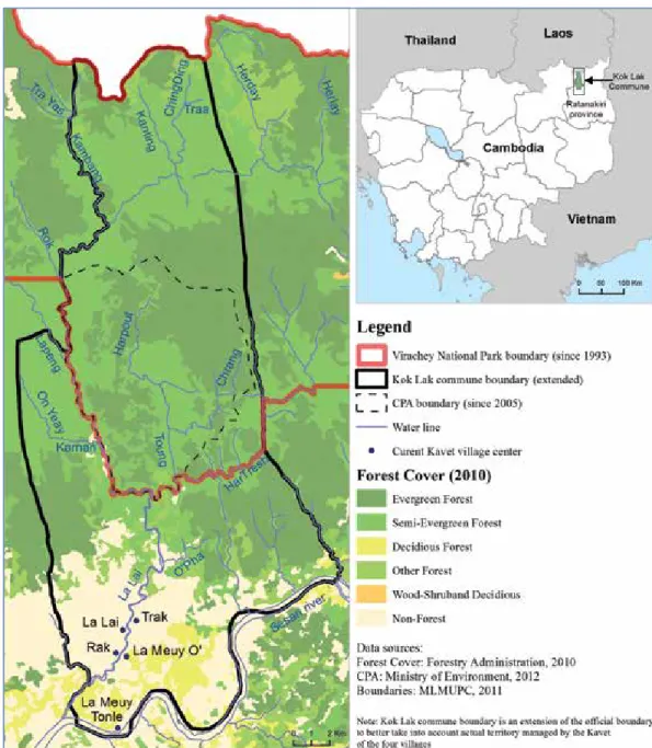
Study area
The research was conducted in Kok Lak commune, located in Veunsai district, Ratanakiri province, and adjacent to the border with Laos (Figure 1). The Virachey National Park, which is the biggest national park in Cambodia (3,380 Km2), represents about 70 percent of the
commune area. Kok Lak commune comprises 2,695 people (441 families) (NCDD 2012). Kok Lak was chosen as the study site in order to build on previous research efforts and because of the establishment of the associated Community Protected Area (CPA), which is a forestry co-management scheme established inside Virachey National Park.
The Kavet people have settled in four villages: Rak, La Lai, Trak and La Meuy. The last village is divided into two sub-groups, La Meuy O’ and La Meuy Tonle. As Figure 1 shows, the villages are situated along the La Lai Stream in the lowland of the commune and are about 50 kilometers north of Banlung city, Ratanakiri provincial town.
Sec
ti
on
C
Figure 1: Location of the Kok Lak commune.
Fieldwork and data collection
In addition to a diversity of secondary data the research is based on primary data collected in Kok Lak commune through different data collection methods. The fieldwork was conducted from 2012 to 2014.
In order to identify historical changes in land use patterns we conducted Participatory Rural Appraisals (PRAs) in all four villages of the commune. Aerial photos derived from Google Earth were used during focus group discussions (of which there were nine) to help participants to identify migration flows that have occurred over the recent past. The drivers and consequences
of these migrations were further discussed in relation to swidden agriculture systems and other land use patterns. A total of 128 people took part in these focus group discussions but only about 10 participants in each village actively responded including elders (traditional authority) and representatives of the Community Protected Area (CPA) committee. We then combined this field dataset with secondary information found in Baird (2013) relating to the criteria for swidden agriculture adopted by the Kavet people, and made them spatially explicit using geo-referenced data. We intersected these different layers in a geographic information system to produce a land suitability map for swidden agriculture that represented the criteria defined by the Kavet people themselves. This suitability identi-fication helps to contextualize and interpret their different migration movements.
Additional information about agriculture techniques, livelihood history, and land use and tenure changes was collected through in-depth interviews. Thirteen people were selected according to their livelihood activities or to their status: six farmers representing different farming practices, three village chiefs, one commune chief and three executive members of the Community Protected Area (CPA) committee.
Household interviews were conducted to understand the history of the families and their land use trajectories, as well as to gather a comprehensive characterization of their farming systems. Overall, we interviewed 42 families, selected randomly based on the Yamane Taro formula (Israel 1992)5. The sampling was facilitated by a database provided by the NGO
Non-Timber Forest Products (NTFP). The first round of household surveys enabled us to elicit the main differentiation trends among households and identify a household typology (five types). We then selected two representative households of each type (n=10) to conduct a detailed survey on food security and income formation. These activities included swidden, rice cultivation, small-scale perennial crop plantation (principally cashew), livestock husbandry, the collection of malva nuts, and timber exploitation. We also included incomes derived from secondary but nevertheless important activities such as fishing, wage labor, handicrafts, the collection of non-timber forest products, and agriculture from home gardens. Data from both in-kind and in-cash gross income was also collected.
THE KAVET SWIDDEN AGRICULTURE SYSTEM
Land suitability for swidden agriculture
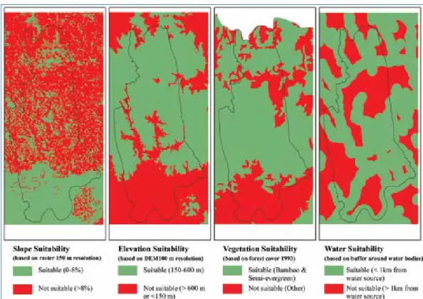
In order to understand the nature of land use change and the impacts these changes have had on local farming systems, we have tried to take a Kavet point of view and consider the rationality and practices of their swidden agricultural system as it was before the 1970s. Based on a triangulation between our primary datasets and secondary data found in Baird (2013) and the availability of geo-referenced data, we defined four ecological criteria that are important for Kavet in assessing the suitability of an area for swidden agriculture.
5 n=N/[1+N(e)2] where n is the sample size, N is the total number of households (HHs) in the village and e is
Sec
ti
on
C
Figure 2: Suitability maps indicating key factors that influence the choice of swidden agriculture
land by Kavet people, according to their ethno-ecological knowledge and preferences.
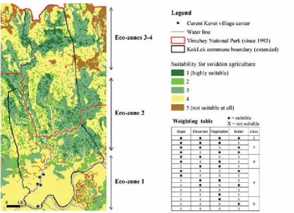
The Kavet ecological classification system is essentially based on two general ecological terms: bree and dak. Bree is a condition of the land according to criteria such as soil, dominant species, and successional patterns in swidden agriculture. Among the 108 ecological classification categories of bree identified by Baird in 1999 (2013), the Kavet people prefer forest types bree baw and bree lao (two types of bamboo forest) and bree lawng (semi-evergreen forest) for swidden. Dak localities encompass rivers and streams with water levels up to the tops of their banks. Dak features are critical for swidden agriculture because they also provide drinking water and opportunities for fishing. Keeping both criteria in mind, we have used the best available data to establish two suitability maps: one relating to vegetation, the other to access to water (Figure 2). Two other criteria taken into account by Kavet communities to determine the suitability of the land for swidden agriculture are slope and the elevation (also shown in Figure 2). Specifically, the land must not be too steep (we have identified a threshold value of 8 percent slope based on data available) and, according to Baird (2013), swidden is typically practiced between 150 and 600 meters above sea level. Using the intersection of these four layers of information and subsequent multi-criteria analysis, we have established a map with five grades of suitability for swidden agriculture (Figure 3). The analysis reveals that areas that are highly suitable for swidden are located mostly (but not exclusively) inside the Virachey National Park. The area south of the commune, where villages are situated, is mostly unfavorable for swidden agriculture.
6 That is the colonization of fallow land by successive types of vegetation
7 Climax vegetation is the vegetation that would flourish in an area, were growth to proceed undisturbed over
a long period
Figure 3: Overall suitability map for swidden agriculture land for the Kavet people, according
to their ethno-ecological knowledge and preferences.
Baird offers a nuanced description of ethno-ecological knowledge created by the Kavet in relation to forest resources and their swidden agriculture, and we used this classification to interpret the suitability map (Figure 3). Baird identifies four different ecological zones in which biological and plant-animal-human relationships are specific. The details of distinct successional patterns on fallow6 are important in differentiating each zone.
Eco-zone 1 is a low and flat land with soil of a relatively low quality (sandy and gravelly). According to Baird, the succession patterns in this lowland area are remarkably different from those in the hilly areas that are just a few hundred meters higher (eco-zone 2). In the lowlands, imperata grass (imperata cylindrica) is the main species that becomes established during fallow periods when the land is not cultivated. The widespread practice by ethnic Lao people of setting dry season fires encourages fallow re-growth and many areas become climax7 imperata grass savanna areas changing from the rich semi-evergreen forests that
were historically found in the northern part of this eco-region (1). This considerably limits the restoration of fertility and thus the suitability for swidden agriculture (Baird 2013). Our surveys have confirmed that Kavet people are fully aware of this and do not consider this eco-zone (1) to be favorable for swidden agriculture. Eco-zone 2 is much more suitable for
Sec
ti
on
C
swidden agriculture, especially where regrowth vegetation is bamboo or semi-evergreen forest (bree lawng) and close to streams. The successional patterns in zone 2 thus differ from those in zone 1. After two to three years of cultivation, the plot is left fallow. The pioneer8
species is not imperata cylindrica but another herbaceous species, which is quickly followed by the appearance of bamboo, wild bananas or semi-evergreen, fast-growing trees (bree lawng). Forests regenerate quickly, and within a few years the canopy is 10 meters high. Fast-growing trees (bree lawng - semi-evergreen) are shaded out by other trees that can grow in the shade of the pioneer and then take over to colonize the area (sciophytes i.e. trees that can flourish at a lower light intensity such as bree gra, then bree greung). In the case of a bamboo forest, bree baw or bree lao becomes the mature forest type. Figure 3 shows that, currently, the Virachey National Park largely overlaps with this eco-zone. Little is known about the ecology of eco-zones 3 and 4. Baird (2013) mentions that successional patterns and pioneer species differ from those of zone 2. However, according to our swidden suitability classification, huge areas are potentially suitable for swidden agriculture in the north (where zones 3-4 are supposed to be located).
The practices of swidden agriculture in the past
Traditionally, Kavet people have tended to cultivate swidden land for about two years on plots ranging from 1 to 3 hectares per household. In addition to the suitability criteria outlined earlier, the size and location of the plots are chosen according to the number of active people within each household.
In the Kavet language, a swidden cultivated plot is called a meur. During the first year of cultivation (meur 1), the Kavet practice multi-cropping within the full extent of the area. Baird (2013) identified 181 different crop types that are regularly cultivated, including 36 varieties of rice and 145 other varieties of annual and perennial crops. In the second year (meur 2), the number of cultivated species and the area size are reduced. Short-term rice and sesame seeds are the crops most commonly grown (Baird 2013).
The duration of the fallow period necessary for the restoration of fertility depends on a number of factors such as the type of forest, the successional patterns and the soil dynamics and natural fertility, but it tends to range from seven to 10 years. Fallow lands are not necessarily unproductive as people may continue to collect fruits and NTFPs from the plot they used for cultivation. Most NTFPs are actually collected on fallow land.
Socio-spatial organization in the past
The village is the traditional socio-spatial unit in Kavet communities. Each is divided into sub-villages of 15-20 families, based on family ties (Ironside and Baird 2003). Each sub-village is usually divided into groups of families from the same lineage. A system of labor exchange exists between three to five families of the same group to manage the peak periods. Families
8 Pioneer species are those that are the first to colonize ecosystems that have been disturbed. They start the
live in different houses within the same residential area located close to a stream and not too far from their swidden agriculture plots. In addition to the core settlement structure, a hut is built by each household directly on their swidden field to be used during the cultivation period.
When a meur is located too far from the village, the village settlement is repositioned to another location in a circular move that usually follows a river. These movements are limited to a territory that makes ecological and social sense to Kavet communities. Kavet do not move continually and should not be viewed as a nomadic population; they have a real sense of territorial belonging.
Before choosing and accessing a new plot (meur), the household’s head informs the elders and then performs a ritual to ask the spirits with a test cutting. This ritual involves cutting a piece of tree from the plot that the family intends to cultivate and bringing it home. If the family members have pleasant dreams the following night, this is interpreted as a positive sign, and they will move to the plot. If they have nightmares, which happens rarely, this is a negative sign, and they will do another test cutting not too far from the plot previously tested.
The village leaders, chosen consensually by everyone in the community, are the major figures of authority and are advised by the elders. Respect for elders is fundamental in Kavet society. Conflicts are addressed by the village leader and elders acting as advisors. When a conflict is linked to spatial conflicts or social taboos, Kavet call it huntre (Baird 2008). An example might be an instance where swidden areas belonging to two different groups overlap.
Land tenure arrangements in the past
The traditional land tenure system of the Kavet is based on common property and individual use rights for the plot under cultivation. Within village limits, land and resources are managed as communal property, and village leaders and elders are responsible for land management and allocation: they are the guardians of group harmony and ensure equitable land allocation between families. According to Ironside and Baird (2003), equality is a central concern in land allocation in Kavet society. There are no land transactions (sale or rent) for fear of spirit retaliation in the form of serious sickness or even death. Moreover, outsiders are not allowed to use village land.
On meur plots, individual households have possession rights (access, use, management and exclusion rights). That is to say that Kavet swiddeners possess the plot during the meur periods, but do not own the land. A land left fallow usually goes back to the collective domain, unless the family continues to use it to harvest fruit and produce from trees. Even so, the land is available for another family to start swidden when the level of fertility is sufficient.
Sec
ti
on
C
Habitation is privately managed with exclusion rights. The villagers can access and exclude others from the parcel of land on which they have settled, but in the village area, household plots are determined by the village leader and elders. Customary law has traditionally prohibited the cutting of trees in the immediate vicinity of village habitation areas.
Spirit forests are important as the center within which spirits reside. The Kavet people believe that spirits live in large rocks, mountains, rivers, streams, trees and houses. These forests are strictly off-limits to avoid disturbing the spirits, and the cutting of trees is not allowed in accordance with customary belief (Ironside and Baird 2003). Burial forests are used only to bury the dead.
In other types of forest, free access and use is available to all villagers. There is no regulation in respect of the amount of resources collected, which can include bamboo, vine, rattan and wild vegetables. Hunting and fishing are also freely allowed. These forests are very important in providing food for the Kavet people, especially during shortages.
DIFFERENTIATION OF LAND USE SYSTEMS IN A CONTEXT
OF MULTIPLE MIGRATIONS
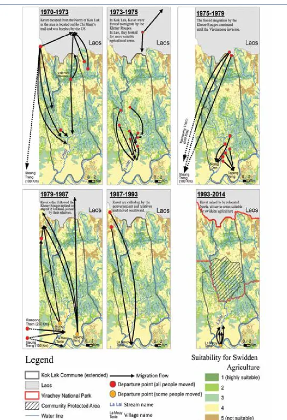
Migrations of Kavet people have occurred several times since 1970 in and around the Kok Lak commune in different waves, driven by different factors and under different circumstances (Figure 4). These migrations are critical in explaining how land use and land tenure systems have evolved and how this evolution has influenced household farming systems.
1970-1973: Indochinese war and the shifting grounds for swidden
agriculture
Up to, and between 1970 and 1973, the Kavet people lived near the border with Laos in an area that was highly suitable for swidden agriculture. However, because the area was located on the Ho Chi Minh trail, the US bombing in the region forced a massive migration. Some groups also moved due to attacks from tigers that have been persistent threats. In relation to their original settlement areas, the Kavet people moved northward into Laos or southward either to Steung Treng province or close to the La Lai Stream. In these new locations (south of eco-zone 2, partly inside what is now the Virachey National Park), lands were still suitable for swidden (Figure 4). All of the Kavet people continued to practice swidden agriculture and their socio-spatial organization did not change.
1973-1975: Khmer Rouge control over swidden agriculture
Between 1973 and 1975, the groups living in Laos moved southward or further north to continue their swidden rotations. Meanwhile, the Khmer Rouge started to control the entire area and the Kavet living close to La Lai Stream areas were forced to move southward. In these places, the Kavet continued to practice swidden agriculture, but the land was less suitable
for this compared with their previous zones of occupation (north of eco-zone 1) (Figure 4). Access to land and forest resources was under the authority of the Khmer Rouge who controlled the allocation of swidden land to the Kavet.
1975-1979: Khmer Rouge and lowland rain-fed rice cultivation
In 1975, the Kavet living close to the La Lai Stream were forced by the Khmer Rouge to move to Norng Dan and Tapeang Veng. Kavet people staying near to the border with Laos were forced to move to the provinces of either Steung Treng or Kampong Thom (Figure 4). Even though the Kavet comprised a small population of people, and had no political connection with the Khmer Rouge, families were dislocated. In these new settlement areas, the Kavet were now engaged in lowland rain-fed paddy cultivation, which was a rather new agricultural experience for them (e.g. seedlings nursery, transplanting and water management). Chamcar crops (non-rice crops) including corn and sugar cane were also produced but on a smaller scale. All land and production were the property of the state. The Kavet were denied any access to forest areas, and the practice of swidden agriculture, along with the collection of NTFPs, was forbidden.
Sec
ti
on
C
1979-1987: Instability, division among Kavet and initial appropriation
of paddies and rice cultivation equipment
After the Vietnamese invasion in 1979, the Khmer Rouge in Kok Lak commune escaped the invaders and government armies and moved to the north near to the border with Laos. A section of the Kavet people were persuaded by the Khmer Rouge to follow them, but this move was not driven by support for Khmer Rouge dissidence, but was rather motived by a desire to re-establish swidden agriculture in the north, which was very suitable for this purpose, and by the fear of being killed by the Vietnamese (Figure 4). However, confusion arose in that the Vietnamese army identified some Kavet as Khmer Rouge soldiers as they were sharing the same territory. The rampant conflict between the Khmer Rouge and the Vietnamese army meant that the entire area was unstable and the Kavet could not practice their swidden system to the full extent. They never stayed in one place for more than one cropping season and food insecurity became a serious issue.
Another group of Kavet stayed in the lowland area of Kok Lak commune along with some others who had moved to Steung Treng and Kampong Thom under the Khmer Rouge regime. At this time, all paddies and rice cultivation equipment that were collectivized during the Khmer Rouge regime were redistributed to individual families. The de-collectivization of land and agricultural equipment was carried out under the supervision of local authorities (village chief and elders) who until then had assumed the role of overseeing the allocation of land for swidden agriculture. Land area suitable for paddy is actually quite limited in the commune, and was distributed to individual families without clear rules. However, it seems that the labor capacity of the family was an important factor in decisions relating to land allocation. Even so, paddies were not available over large areas so the people who were the first to benefit from this rice land distribution received land with greater soil fertility and potential for intensification. Agricultural equipment as well as draught animals were redistributed to the individual households but quite a few were allocated on a ‘first come, first served’ basis to families who were engaged in rice cultivation.
At the same time, the return to swidden agriculture was limited by several factors. For a start, the region was still largely unstable as a result of persistent conflicts between government/ Vietnamese armies and the Khmer Rouge and so it was risky for the Kavet to venture into the forest. Families also needed family labor and resources for rice production, thus resources available for swidden plots had diminished. So people started to look for alternatives and turned to the cultivation of non-rice (chamcar) crops on upland plots located on the periphery of villages, beyond the residential area and home gardens. The crops grown were similar to those in the swidden plots (mostly vegetables for self-consumption) but they were cultivated on a permanent basis (not under a swidden system with fallow periods). Access to these chamcar lands – and to paddies - was managed by village leaders and elders under the close supervision of the Vietnamese as was the case in the rest of the country at that time. Each household was given a parcel of 1500 sq. meters. However, some families with low labor capacity received smaller land areas. Our interviews revealed that households experienced no restrictions or exclusions in terms of the allocation of these chamcar lands.
Sec
ti
on
C
1987-1993: Deepening inequality in access to paddies
At the end of the 1980s the Vietnamese army left the area, and peace and stability were re-established. Donor-supported state projects (e.g. the UNDP Cambodia Reintegration and Rehabilitation (CARERE) project) arrived in Kok Lak with various development assistance services. These included rice cultivation equipment and draught animals for paddy farmers and the rehabilitation or construction of physical infrastructure (i.e. roads). NGOs also started to be involved in the area. With growing stability, security and the provision of social services, Kavet swiddeners moved back from their refuge near the border with Laos southward to the lowland areas where their fellows from the Kavet population of Kok Lak had concentrated (Figure 4). These migrations created a high demand for paddy land. But most of the lowland paddies with good soil quality and rice cultivation equipment and draught animal were already appropriated and distributed to those who had stayed behind during the Vietnamese period. The new migrants were therefore given paddy lands that were distributed by the Kavet traditional authorities but only on smaller plots with lower soil fertility. They benefited from the distribution of agricultural equipment and draught animals, but in smaller quanti-ties. Our survey shows that the main reason for this return migration was not so much an interest in lowland rice cultivation but rather to practice swidden agriculture in the areas the Kavet people had used before the Khmer Rouge regime. The arrival of these new migrants in lowland rice cultivation areas marked a renewed movement to swidden agriculture north of villages in eco-zone 1 and further north into eco-zone 2 (Figure 3).
This difficulty in accessing paddies and rice cultivation equipment exacerbated the differentiation processes initiated earlier, and two main groups of farmers emerged. On the one hand, there were those who had become primarily lowland rice farmers (with a land area size that allowed them to be food secure) and who were settled and conducting agriculture in the lowland area (eco-zone 1). Swidden agriculture and chamcar remained an element of their livelihood diversification strategy but their interest was focused on permanent agriculture. They practiced swidden agriculture not too far from their villages in the north of eco-zone 1, in areas that were mostly unfavorable for swidden agriculture (see above). On the other hand, another group of households moved further north to conduct swidden agriculture in an area that was more suitable for swidden (eco-zone 2, along the La Lai Stream, which includes a large area inside the present-day Virachey National Park). They decided to move back to this swidden area because they had a rice land area size that was insufficient for them to be food secure and/or because they had a greater labor capacity that allowed them to engage in both lowland rice and swidden agriculture.
1993-2014: State denial of swidden agriculture and the emergence
of cashew plantations
In the early 1990s, Kavet settlements remained adjacent to the Sesan River, but the people requested to be relocated further north, closer to lands that were more suitable for swidden agriculture. Even though the government and NGOs continued to encourage the Kavet to cultivate paddy and remain in the lowland area, the village settlements were relocated
north to their current location (Figure 4). This allowed them to return to swidden agriculture in areas that they had used for this purpose in the early 1970s. This move was managed under the authority of village leaders and elders in the same way as had been the case in previous settlements in 1987. Many families then returned to their swidden plots located along the La Lai Stream and some to areas to the very far north of the village.
Virachey National Park (VNP) was officially established as forest Protected Area in 1993 but its management did not come into effect until 1998 (Baird 2013) (Figure 4). The establishment of the VNP took place without consultation with the Kavet (Baird 2013) and swidden agriculture is strictly forbidden inside this area, although the park encroaches upon large areas of Kavet swidden land (north of eco-zone 1 and the full extent of eco-zone 2, Figures 3 and 4). However, the majority of people continued to conduct swidden agriculture. In 2005, the government established a Community Protected Area (CPA) consisting of several zones where rules and forest practices were declared in co-management with the Ministry of Environment. CPA rules are aligned with the mandate of Protected Areas, which forbids the practice of swidden agriculture. The enforcement of CPA regulations has put further pressure on the Kavet to cease swidden agriculture in the area. For lowland farmers mostly involved in permanent lowland agriculture, the decision has had little effect as their swidden plots are located outside of the Protected Area. In contrast, the establishment and enforcement of the CPA will have a particularly significant effect on those who have moved northwards and are more dependent on swidden agriculture for their food security.
In a parallel process, the development of family-scale cashew plantations will affect Kok Lak commune. Cashew plantations actually began in the late 1990s but were in full swing in Kok Lak from 2005 to 2010. In this period, the interest of Kavet people in income generation from cashew plantation increased and the conversion of swidden plots to perennial crop plantation became common practice. Cashew production is not a very time-consuming or input-intensive activity and the proximity of the large Vietnamese market means that the cultivation of cashew nuts will continue to be a widely adopted diversification strategy. The change has tended to start with lowland farmers who transform their swidden land (south of the present-day VNP) in areas where the successional patterns are not favorable for swidden agriculture (north of eco-zone 1) but also because these households have lost interest in this traditional practice. But the change to the cultivation of cashew nuts is also expected to be pursued by the upland famers currently involved in swidden agriculture in areas of eco-zone 2 located outside VNP. The push factor is related to the reduction in space that has resulted from the establishment of the Protected Area, which is forcing a reduction in fallow periods and is thus limiting soil fertility. The pull factor is the opportunity offered by the emerging market for cashews. The conversion of swidden plots into cashew plantations has been proceeding gradually alongside the continual practice of swidden agriculture, both inside and outside the VNP. However, the traditional leaders and elders in Kok Lak have decided to limit the area of cashew plantation, especially in areas adjacent to the VNP, in order to keep the lands available for swidden agriculture, which remains an important activity for many household farming systems.
Sec
ti
on
C
The process involved in the acquisition of land to establish cashew plantations has been poorly regulated and has operated on a ‘first come, first served’ basis. As in the case of rice land appropriation, an important parameter that differentiates people in access to cashew land is the time when the conversion of swidden or forest into cashew plantation took place. Our interviews suggest that the availability of fallow land allows those who are the ‘first comers’ to acquire larger areas and land with a higher fertility value. The distances from the village settlement and accessibility by bicycle and motorbike to transport produce to market are important criteria in the choice of cashew plantation areas made by the ‘first comers’.
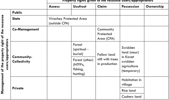
Land tenure changes
Collective ownership and community-based land tenure arrangements that were once the core institutions for governing the access to, use of, and control over land are evolving in two different ways with respect to economic development (Table 1). Factors affecting this evolution of tenure arrangements include a higher degree of commoditization, demographic or population increase, the policy for Protected Areas (PAs) and cultural influences from outside individuals and organizations.
For the past 40 years, and especially since the 1990s, the different forms of land tenure that have prevailed for swidden agriculture have evolved towards the individualization of private land property rights. This is a direct consequence of the demise of swidden agriculture resulting from higher commoditization of land and resources associated with the development of rice cultivation and cashew plantation. The privatization of land rights allows people to have a permanent claim on land and to be able to transfer land to the next generation or sell it in a market system. Privatization is also a self-driven process because the advance of private and permanent agriculture, combined with the establishment of large PAs, has considerably limited the area available for swidden, which includes the cultivated plot (meur) and a larger fallow area. Privatization of land reduces the availability and duration of the fallow period, which limits the development of swidden agriculture, thus creating the incentives for conversion and privatization. However, in remote areas, the practice of swidden agriculture has not disappeared along with meur and fallow land, and thus the community-based rules of access and use by Kavet still apply.
Table 1: The diversity of land tenure regimes in present day Kok Lak
Property rights given to the resource users/appropriators Access Usufruct Claim Possession Ownership
Mana gement of the proper ty right of the r esource users/appropria tors Public
State Virachey Protected Area (outside CPA) Co-Management Community Protected Area (CPA) Community-Collectivity Forest (spiritual -
burial) Fallow land still with trees in production Swidden land (meur) in Kavet swidden agriculture (temporary) Forest (other) (NTFPs, fishing, hunting) Private Habitation in village Rice land Cashew land Source: Authors, adapted from Le Roy et al.1996
Note: See footnotes 3 and 4 for an explanation of the specific terms used in this table
With the creation of the Virachey National Park the state has re-introduced certain forms of control over land rights. Protected Area management rules forbid swidden agriculture, so, instead of being allowed to practice swidden agriculture, the Kavet were consulted to establish a forest resources co-management scheme inside the Protected Area, which became the Community Protected Area (CPA). In this area (measuring 9,909 ha), the management of resources is jointly designed and enforced by the community and representatives of the Ministry of Environment. This co-management scheme has been put in place to regulate the access to, and use of forest resources for the Kavet. The practice of swidden agriculture is forbidden inside the CPA.
After several years, an area that was mostly used for swidden agriculture and managed under collective rules defined by Kavet communities has abruptly changed. The local institutions of the Kavet now have to play with different rules for land use relating to private claims and the alienation of land rights to state control. The Kavet were not necessarily prepared to engage with this legal pluralism and fragmented land tenure system. But they are now fully aware of the implications. They have not passively accepted these pressures and have mobilized to protect their livelihood assets and strategies. But they are also not resisting all new forms of agriculture such as cashew. They are adopting new practices and engaging with markets. But in many situations swidden is still important to their livelihood strategies, and they have consequently consistently requested to keep access to swidden agriculture land and to be able to rely on their own tenure system in some parts of the enclosed Virachey National Park, which they consider as the core of their homeland. We observed that the so-called CPA has not managed to address this legitimate claim in a very satisfactory way.
Sec
ti
on
C
DIFFERENTIATION OF HOUSEHOLD FARMING SYSTEMS IN KOK LAK
As a result of the complex transformation in land use systems, Kavet cropping systems are composite in that they consist of different crops and activities (swidden, paddy, cashew, NTFPs, and so on), which are managed under different land/resources tenure regimes. We indicated earlier the challenges of navigating in a context of institutional and legal pluralism, but the composite nature of cropping systems obliges swiddeners to navigate different cropping seasons which involve different calendars, different locations (sometimes far from each other), different peaks of labor, different technical itineraries, and so on. We suggest that not all households have been influenced by, or have contributed evenly to, these transformations and in our research study we were particularly interested in eliciting the different household trajectories.
Differentiation drivers and trends
The year 1993, marking the establishment of the Virachey National Park, was pivotal in the differentiation of land use at commune and household levels. The ban on swidden agriculture in the Park has certainly forced the Kavet to revise their cropping activities, but we have also shown that new opportunities from the cashew market have created significant incentives to convert swidden into small-scale plantations.
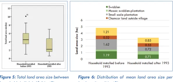
The commune data on landholdings and land use practices at household level indeed reveals important differences between families established before or after 1993. The transformation of cropping practices obviously took place over a longer period of time, but 1993 is an important milestone.
Figure 5: Total land area size between
households in Kok Lak9 (N=42)
Figure 6: Distribution of mean land area size per
land use item (N=42)
9 Box plot graph indicates the values of five descriptive statistics. The central value is the median. The lower
and upper limits of the box are the first and third quartiles respectively. The inferior and superior limit equals the first quartile respectively minus and plus 1.5 x distance between 3rd and 1st quartile. All values outside this range are called singular values
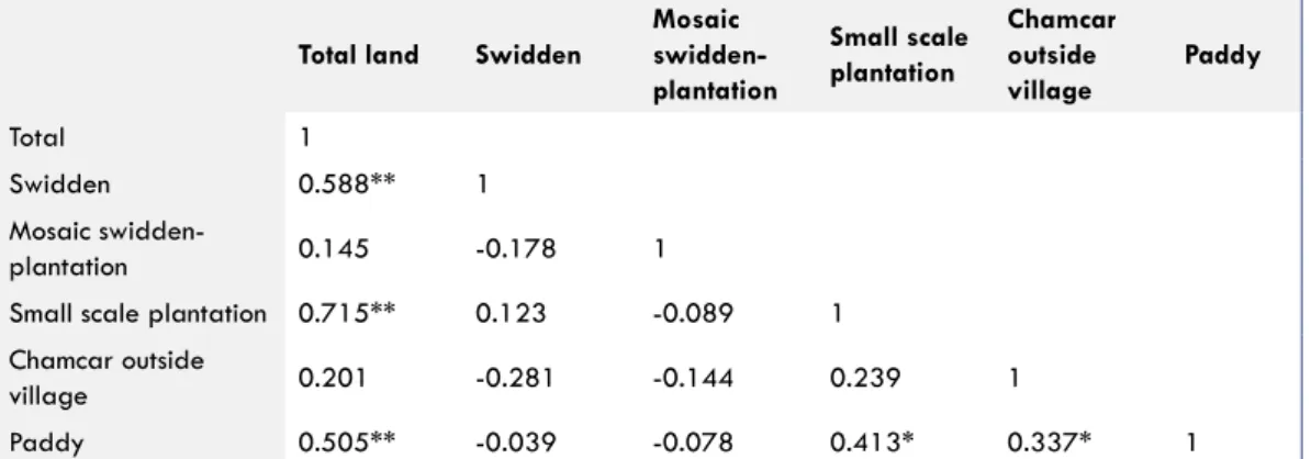
The households established in Kok Lak before 1993 have a significantly larger landholding size (4.80 ha) than those installed after 1993 (3.17 ha) (Analysis of Variance (ANOVA): F=4.934, p=0.033) (Figure 5). When considering specific land use (Figure 6), there are also significant differences between households installed before and after 1993. The size of paddy is significantly different between both groups of households (1.21 and 0.85 ha, ANOVA F=3.332, p=0.0436), which suggests that the effect of unequal access to paddy, initiated in the 1980s, is still clearly visible today. The difference in landholding size for small-scale plantation is also significant between households installed before 1993 (1.62 ha) and those after (0.72 ha) (ANOVA; F=8.474, p=0.006). As for swidden, the differences are clear but are not statistically significant. Swidden is now forbidden for both groups of households and access to meur lasts for only two years before the plot returns to the common land pool. In this way, land accumulation is not possible. We also note a significant correlation between area size of total landholdings, small-scale plantations and paddy land area size (Figure 7), which suggests that both processes of land accumulation (rice and small-scale plantations) have benefited the same households.
Total land Swidden
Mosaic swidden-plantation Small scale plantation Chamcar outside village Paddy Total 1 Swidden 0.588** 1 Mosaic swidden-plantation 0.145 -0.178 1
Small scale plantation 0.715** 0.123 -0.089 1 Chamcar outside
village 0.201 -0.281 -0.144 0.239 1
Paddy 0.505** -0.039 -0.078 0.413* 0.337* 1
Figure 7: Pearson Correlation of land area size per type of land use
**. Correlation is significant at the 0.01 level (2-tailed). *. Correlation is significant at the 0.05 level (2-tailed).
Our findings suggest that there are three distinct elements that explain this differentiation process.
1) In a context where land appropriation follows the rule ‘first come, first served’, it is clear that the households who were present and able to make a land claim when they had the opportunity to do so are at an advantage. These households received paddy land and were later occupying lowland swidden areas and were reactive in converting them to cashew plantation. This has particularly benefited those households who were well connected to past authority. In a context where the land is now privatized to a large extent, and where the possibilities of further expansion of the agricultural area are limited, these inequalities are now reproduced by inheritance.
2) Given that access to land was conducted through unpaid appropriation, the family labor capacity has been decisive in determining the area that could be accessed. The difference in active labor between households installed before 1993 and those installed after, is also statistically significant, 4.52 versus 2.81 people, respectively
Sec
ti
on
C
(ANOVA F=10.617, p=0.002). Nowadays, the household labor capacity explains why some families continue to engage in swidden agriculture in areas located far from villages. Over the past 25 years the relationships of people to the land have completely changed. In this context the differentiation process at play is still profoundly marked by the demographic differentiation, which is indicated by the evolution of the dependency ratio of the households (number of non-active to active people) that evolves along its life cycle.
3) The age of the household also reveals important differences in respect of interest in swidden agriculture: Sixty-five percent of households installed before 1993 are still involved in some form of swidden agriculture whereas only 14 percent of households installed after 1993 practice this activity. Indeed, our interviews revealed that most young people (but not all) are less interested in swidden agriculture than are their elders. This interest in non-swidden forms of agriculture or even in non-farm activities is another important element influencing current land use practices, and this also explains the interest younger households have in permanent agriculture (paddy and small-scale plantations).
Differentiation and typology of farming systems in Kok Lak
Before the 1970s Kavet families were living mostly on swidden agriculture in large forest territories. They enjoyed considerable freedom to practice their swidden agriculture and to interact with outsiders through various timber and NTFP trade activities.
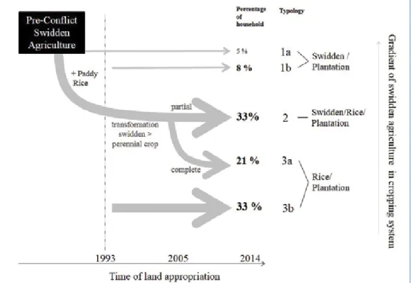
Over the past 40 years, we suggest that various drivers of differentiation have been at play that have profoundly transformed the swidden system practiced by the Kavet. These include the appropriation and integration of paddy in their cropping systems, the dramatic reduction of areas where swidden is allowed due to Protected Areas regulations, and later the conversion of swidden and/or appropriation of forest into small-scale perennial crop plantations. We identify three very distinct trajectories of evolution reflecting different degrees to which the swidden system has been transformed. The different types are positioned on a gradient that indicates the relative importance of swidden agriculture in the current farming systems of the people concerned (Figure 8). The distribution of mean land area size per type of land use is presented in Figure 9.
Figure 8: Differentiation and typology of farming systems in Kok Lak
Sec
ti
on
C
Type 1 - Swiddeners
Type 1 consists of households who never received paddy land because they were not present when the distribution of paddy land and agricultural equipment took place at the end of 1980s/early 1990s (type 1a, 5 percent of the sample) or because they were too young to benefit from it as an individual household (type 1b, 8 percent of the sample). In total, they represent 13 percent of our sample. They have lived a swidden lifestyle in the uplands since the end of the war and the socio-political instability of the 1980s, and are still mostly relying on swidden agriculture and forest common pool resources as a main source of livelihood. Given the constraints on swidden agriculture, they are being persuaded to convert swidden plots into cashew income and secure land for their next generation. But this transformation is very gradual given the time needed before these plantations become productive. But most of their landholding still consists of plots with swidden agriculture (Figure 9).
Type 1a households have relatively smaller landholdings per active laborer (mean=0.39 ha; min=0.28 ha; max=0.50 ha) as a result of low labor capacity combined with the fact that more resources are allocated to the collection of forest common pool resources (including fishing). Household groups under type 1b are younger, with higher labor capacity, and are mostly living on swidden land adjacent to the CPA with a larger land area size per active laborer (mean=0.894 ha; min=0.61 ha, max=1.26 ha) (Figure 9). The food security of types 1a and 1b has greatly suffered from recent changes in land use and the limitation of swidden grounds. Forty percent are said to be food secure through their own food production, but they are highly dependent on the collection of Common Pool Resources (CPRs) and on market-based activities such as selling malva nuts to make ends meet.
The detailed case study on income reveals that forest-related activities represent an important share of the total gross income (estimated at USD 1,645 annually: 53 percent in-kind and 47 percent in-cash). Income from swidden agriculture represents 34 percent of this total income. The weakness of this income is compensated for by the collection of malva nuts from the CPA (35 percent) and by a diversity of other activities (fishing, handicrafts, NTFPs and chamcar) which, when accumulated, represent 18 percent and are therefore certainly not negligible.
Omitting these households from land and agricultural equipment distribution associated with the establishment of the Protected Area has rendered them quite poor and vulnerable. Future perspectives for households of type 1 (1a and 1b) are somewhat limited and depend greatly on the future management of the CPA and how the question of swidden agriculture will be addressed. For these households, there is a crucial need for swidden agriculture to be allowed, while inclusive access of these households to the CPA is maintained.
Type 2 - Composite swiddeners
Households of type 2 are composite swiddeners in that they have a diversified portfolio of activities and income opportunities. They are all households installed before 1993 (with the exception of one household that was integrated within the group) and represent 33 percent of
households in our sample (Figure 8). They have confronted all the different forms of change in land use systems, which they have somehow managed to incorporate. They are all involved in swidden agriculture but also have paddy land. They have converted a part of their swidden land into cashew production. Their interest in, and attachment to, swidden agriculture, associated with a significant labor capacity, allow them to conduct agricultural activities in the lowland (rice and small-scale plantations) along with swidden agriculture in the upper north in an area adjacent to the CPA.
Households in this type have the largest landholdings in the commune as well as the largest landholdings per active laborer (mean=1.87 ha; min=0.57 ha; max=5.05 ha) (Figure 9). Sixty five percent of households in this type declare themselves to be food secure. Our datasets and observations suggest that swidden agriculture buffers households with smaller landholdings in the lowland area (paddy or small-scale plantation) from the risk of food insecurity.
Type 2 households have the highest annual income among all the three types (USD 2,398 per year). Their labor capacity allows them to engage in different activities and to diversify their income. However, swidden agriculture and collection-sale of malva nuts remain the most significant in the income structure (representing 16 and 22 percent, respectively, of total gross income).
Access to a diversity of land use opportunities is an asset to households in type 2 and the future prospects for this group are better than they are for households in type 1. However, the continued reliance on swidden agriculture and the importance it has for the poorest of this group reinforce the need to reconsider the place, role and recognition that is presently given to it.
Type 3 - Lowland rice growers
Unlike type 2, households in type 3 have totally transformed their swidden land into cashew plantations (type 3a, 21 percent of the sample) or have never engaged in swidden (type 3b, 33 percent of the sample) (Figure 8). The reason why type 3a households have abandoned swidden is related to the continued pressure exerted on swidden, and the resulting exiguity of fallow land and a marked preference for lowland, permanent agriculture. For type 3b households the reason for not engaging in swidden is related to low labor capacity (2.4 laborers per household on average) that prevents them from working simultaneously in lowland rice cultivation and on plantations.
Type 3b households are younger and were installed after 1993: they have mostly inherited rice land from their parents and/or have had the capacity to mobilize resources to materialize their claim to small-scale plantations and to access chamcar land outside of the village, despite a lower labor capacity.
These observations translate into mean land area sizes per active laborer. The type 3a household land-holding size per active laborer is 0.87 ha (min=0.4 ha; max=1.75), while
Sec
ti
on
C
the area size for 3b type households is 1.64 ha (min=0.3 ha; max=4 ha). The average income appears to be lower for households of type 3a (USD 1,031/year) than of type 3b (USD 1,537/year). Types 3a and 3b mainly earn their income from paddy and malva nuts. 3b households also gain from other income-generating activities such as wage labor - related or not to migration or to more illicit activities including illegal logging, which we were not able to assess accurately.
The future prospects for these households lie essentially in their capacity to reinforce their lowland agricultural systems. The possibility to expand cultivated areas is limited so the improvement needs to come from existing land resources. The challenge will be even more difficult to overcome in the future when all of the private landholdings of these households are divided through inheritance. Improving the productivity of small-scale plantations via intercropping of an annual crop is a first possibility. Systems of rice intensification that do not demand substantial inputs should be recommended to increase yield. This can be promoted through the adoption of integrated multi-purpose farming (MPF) systems that include aquaculture and livestock production.
CONCLUSION AND RECOMMENDATIONS
Over the course of the past 40 years, forced and free migration has reshaped the swidden landscapes of the Kavet people. Irrespective of the nature of the forces that drive these migrations, we have identified a consistent trend on the part of the Kavet to move back to the core of their swidden territories. This trend is an expression of the Kavet communities’ determination to practice swidden agriculture despite a changing environment.
With the establishment of the Virachey National Park (VNP) in 1993, the state has become an important actor presiding over Kavet destiny. VNP overlaps large areas of the swidden grounds formerly used by the Kavet. The ban on swidden agriculture within the Park has considerably reduced the availability of land for fallow, thus putting the swidden system of the Kavet in jeopardy.
In a parallel process, the development of permanent lowland agriculture has given important incentives to some Kavet people to quit swidden agriculture and to stabilize their agricultural activities in lowland areas. However, a significant number have remained composite swiddeners in that they practice both swidden agriculture and paddy cultivation. The development of cashew production through small-scale plantations at household level will create further incentives for the Kavet people to transform part of their swidden land into permanent perennial crop plantation.
The swidden territories of the Kavet are now much more fragmented and present a mosaic of different land use and land tenure regimes. At the center lies a contradiction between, first, those agricultural systems that represent a permanent claim over private land, and that allow for commodification and accumulation (rice and small-scale plantation), and, second, those agricultural systems that represent an impermanent claim over land by local institutions,
that prevent any forms of accumulation (swidden agriculture). At the household level, the farming systems that result from these transformations are hybrid and consist of an association of different land use practices such as paddy rice, swidden, and small-scale perennial crop plantations. These still rely on forest common pool resources and fisheries activities. People are not resisting nor fully embracing these new forms of agriculture. Instead, they are using them according to their own interests and asset base to create a diversified livelihood. Among the different trajectories of evolution we have identified is the undeniable interest in non-swidden agriculture and non-farm activities on the part of younger households. However, despite the strong push and pull away from swidden agriculture, we have shown that swidden still plays a vital role in the Kavet communities of Kok Lak commune. It is practiced by nearly half (46 percent) for whom it represents a significant part of their income and is an important element in supporting household food security.
This chapter has shown a misfit between the land use changes that have affected farming systems, and the institutional instruments put in place to frame these transformations. A co-management scheme between the Kavet people and the state has been established to devolve part of the management of forest resources to the local community in an attempt to reduce poverty and to promote inclusive development. But swidden agriculture is not playing any role in this scheme despite its importance to their sense of identity and their way of living.
In this context, we keenly recommend that all relevant stakeholders (farmers, swiddeners, commune and traditional village authorities, representatives of the CPA and the Ministry of Environment) become engaged in a more detailed land use inventory and planning exercise where central questions about land availability and use, as well as the requirements of future generations, can be articulated and the diversity of interests and needs within the communities, consequently recognized. The recognition of the role swidden agriculture plays in the community, and a focus on integrating it into on-going conservation efforts, is particularly important.
The Cambodian legal framework offers a good basis to conduct land use planning at village and commune level with the participation of all relevant actors. This planning needs to widen its scope so that it is not restricted to CPA management. For instance, the demarcation of a community development zone, as set out in the Law on Protected Areas, could be used to open up a larger space for swidden agriculture.
In a wider perspective such land use planning should serve as a forum in which the Kavet are able to critically review past transformations of their land use systems and project themselves into the future with both forward planning and directed activities that balance the needs of their entire population.
Sec
ti
on
C
ACKNOWLEDGEMENTS
The authors would like to thank the International Development Research Centre (IDRC) of Canada for supporting this project.
We would like to address our thanks to all respondents and participating farmers who have been involved in this project. The research was also possible through the collaboration of multiple stakeholders including representatives from the Provincial Hall of Ratanakiri, Kok Lak commune and village authorities, and the NGO Non-Timber Forest Products.
The authors are grateful to Mr. Mean Ratanak and Mr. Nhim Tum, former Research Officers, for sharing their ideas and documents related to this research project and for guiding the preliminary steps of the analysis. We are also grateful to Mr. Jeremy Cuvelier, junior Research Advisor with the Learning Institute, for his support during the literature review, Participatory Rural Appraisal (PRA) and questionnaire design. We are also thankful to students from Mean Chey University, Prek Leap National School of Agriculture, the Royal University of Phnom Penh and the Cambodia Indigenous Youth Association for their support during data collection. The students are namely Mr. Det Neang, Ms. Rith Narin, Ms. Loam Chiva, Ms. Ros Saem, Ms. Noan Sereyroth, Ms. Ploeng Sreynget, Ms. Kram Socheat, and Ms. Morng Channy. Credit should also be given to Mr. Ron Jones for English proof reading and Dr. Jan Taylor who undertook the complete and final editing process.
The Learning Institute and the authors have also greatly benefited from comments and suggestions made by the external peer reviewer, Dr. Jeremy Ironside, of the McKnight Foundation. The authors are responsible for any remaining errors in the text.
BIBLIOGRAPHY
Backstrom, M., Ironside, J., Paterson, G., Padwe, J. and Baird, I. (2007) Indigenous Traditional Legal Systems and Conflict Resolution in Ratanakiri and Mondulkiri Provinces, Cambodia. Phnom Penh: United Nations Development Programme. Baird, I. (2008) The Case of the Brao: Revisiting Physical Borders, Ethnic Identities and
Spatial and Social Organisation in the Hinterlands of Southern Laos and Northeastern Cambodia, Études thématiques, 18, pp. 596-620.
Baird, I. (2009) Controlling the margins: Nature conservation and state power in northeastern Cambodia. in Bourdier, F., (ed.) Development and Dominion: Indigenous Peoples of Cambodia, Vietnam and Laos, Bangkok: White Lotus Press. pp. 215-248.
Baird, I. (2013) The Ethnoecology of the Kavet Peoples in Northeast Cambodia. in Poffenberger, M., (ed.) Cambodia’s Contested Forest Domain: The Role of Community Forestry in the New Millennium, Manila: Ateneo De Manila University Press. pp. 155-186.
Baird, I. (2010) Making spaces: The ethnic Brao people and the international border between Laos and Cambodia. Geoforum, 41, pp. 271-281.
BPAMP (2005) Participatory development of management plans for Protected Areas in Cambodia, Biodiversity and Protected Areas Management Project Phnom Penh: Ministry of Environment.
Condominas, G. (2009) Anthropological Reflections on Swidden Change in Southeast Asia. Human Ecology, 37, pp. 265-267.
Cramb, R. A., Colfer, C. J. P., Dressler, W., Laungaramsri, P., Quang Trang, L., Mulyoutami, E., Peluso, N. L. and Wadley, R. L. (2009) Swidden Transformations and Rural Livelihoods in Southeast Asia. Human Ecology, 37, pp. 323-346.
De Koninck, R. (2006) On the Geopolitics of Land Colonization: Order and Disorder on the Frontiers of Vietnam and Indonesia. in Dufumier, M., (ed.) The Agriculture in
Southeast Asia: An Update, Paris-Aix: EDISUD. pp. 33-59.
Ducourtieux, O. (2006) Is the diversity of shifting cultivation held in high enough esteem in Lao PDR? in Dufumier, M., (ed.) The Agriculture in Southeast Asia: An Update, MOUSSONS 9-10. pp. 61-86.
Sec
ti
on
C
Ducourtieux, O., Laffort, J.-R. and Sacklokham, S. (2005) Land Policy and Farming Practices in Laos. Development and Change, 36(3), pp. 499-526.
Fox, J. M., Fujita, Y., Ngidang, D., Peluso, N., Potter, L., Sakuntaladewi, N., Sturgeon, J. and Thomas, D. (2009) Policies, Political-Economy, and Swidden in Southeast Asia. Human Ecology, 37, pp. 305-322.
Fox, J. M., McMahon, D., Poffenberger, M. and Vogler, J. (2008) Land for My Grandchildren: Land-Use and Tenure Change In Ratanakiri: 1989-2007, Community Forestry International (CFI) and the East West Center.
Ironside, J. and Baird, I. (2003) Wilderness and Cultural Landscape: Settlement,
Agriculture, and Land and Resource Tenure in and adjacent to Virachey National Park, Northeast Cambodia. Banlung: Ministry of Environment, Department of Nature Conservation and Protection.
Israel, G. D. (1992) Determining Sample Size. Factsheet PEOD-6, University of Florida. Le Roy, E., Karsenty, A. and Bertrand, A. (1996) La sécurisation foncière en Afrique. Pour une
gestion viable des ressources renouvelables, Paris: Karthala.
Mikkelsen, C., ed. (2014) The indigenous world 2014, Copenhagen International Work Group for Indigenous Affairs (IWGIA).
NCDD (2012) Commune Database Online, Available at: http://www.ncdd.gov.kh
Padoch, C., Coffey, K., Mertz, O., Leisz, S. J., Fox, J. M. and Wadley, R. L. (2007) The Demise of Swidden in Southeast Asia? Local Realities and Regional Ambiguities. Danish Journal of Geography, 107(1), pp. 29-41.
Phath, M. and Sovathana, S. (2012) Country Technical Notes on Indigenous Peoples’ Issues. Kingdom of Cambodia. Phnom Penh: IFAD Cambodia.
Schmidt-Vogt, D., Leisz, S. J., Mertz, O., Heinimann, A., Thiha, T., Messerli, P., Epprecht, M., Pham, V. C., Vu, K. C., Hardiono, M. and Truong, M. D. (2009) An Assessment of Trends in the Extent of Swidden in Southeast Asia. Human Ecology, 37, pp. 269-280. Scott, J. C. (2009) The Art of Not Being Governed. An Anarchist History of Upland Southeast
Asia, Yale Agrarian Studies Series, New Haven & London: Yale University Press. Tol, S. and Srey, M. (2010) Malva nuts and co-management: can the poor benefit? in
Frieson, K., (ed.) Social Landscapes and Rural Livelihods. Cambodian Communities in Transition, Phnom Penh: The Learning Institute.